Advertisement
If you have a new account but are having problems posting or verifying your account, please email us on hello@boards.ie for help. Thanks :)
Hello all! Please ensure that you are posting a new thread or question in the appropriate forum. The Feedback forum is overwhelmed with questions that are having to be moved elsewhere. If you need help to verify your account contact hello@boards.ie
Tom Tom new UK & IRL map released today
Options
Comments
-
@irish-stew
Firstly, welcome to the GPS section!
I'd recommend you open a new thread, as you're likely to get lost in this one, but as a quick reply to get you going....
TomTom do a "latest map guarantee" with all their new units.
Your Mum should have got an "activation code" card in the box along with the device. You need this to register the unit, and get the latest maps for free, which can all be done using the included TomTom Home software.
As far as pre-planning routes is concerned, that's fairly handy, by setting up "Favourites", which are a list of locations you enter into the device. If you select a "Favourite" the unit will plot a route from wherever you, are at that time. So enter in as many favourite destinations as you like.
If you've any other questions, open up your own thread, and I'll try to help.0 -
@irish-stew
Firstly, welcome to the GPS section!
I'd recommend you open a new thread, as you're likely to get lost in this one, but as a quick reply to get you going....
TomTom do a "latest map guarantee" with all their new units.
Your Mum should have got an "activation code" card in the box along with the device. You need this to register the unit, and get the latest maps for free, which can all be done using the included TomTom Home software.
As far as pre-planning routes is concerned, that's fairly handy, by setting up "Favourites", which are a list of locations you enter into the device. If you select a "Favourite" the unit will plot a route from wherever you, are at that time. So enter in as many favourite destinations as you like.
If you've any other questions, open up your own thread, and I'll try to help.
unless something has changed.....TT do not supply activation code cards with their hardware. Its determined on first sync via tomtom home client software.
NB....first SYNC, not first fix like garmin!
either way, for the satNav, virgin your caught!
unless ( that is ) your entitled to it.......map update that is!
happy after Xmas0 -
Here we are again - at that time of year when the usual complaints about SatNav’s received for Christmas or in the New Year’s sales begin.
This year I would ask you to read this post once at least before you make your complaint so that you have some background to the technology that is a SatNav. Furthermore, this is an Irish perspective and SatNav’s in Ireland have very particular Irish problems which should be taken into account.
SatNav’s are now one of the most popular consumer items in Ireland with an estimated 0.5 million in use and a projection for more than 1 million in the country by 2010. Basic SatNav’s have halved in price in the last 18 months.
This post is written by way of giving some background to SatNav use in Ireland which may help explain some of their apparent shortfalls.
SatNav’s, no matter who makes them, consist of 4 main elements – a GPS receiver, Digital Road Mapping, the User themselves and the software to bring the first three together…………..
As for the GPS receiver itself;- GPS, meaning a Global Positioning System which, by its very name, means that it can be used anywhere in the world including Ireland. However, a GPS receiver must be able to see the sky to work and if yours is not getting a position it is normally because you have located it so that it cannot see enough sky. The signal from GPS Satellites is so weak that even your hand can block it. There also may be antiglare treatment on your windscreen which is blocking the signal or, maybe you have a front window heater which can also block the signal. The first of these happens routinely when a SatNav is put into a hire car abroad. In both cases, if your SatNav supports an external antenna then this will solve the problem. If it does not, then you have the wrong SatNav for you.
If you are in any doubt about your SatNav, take it into the open air, allow it see the sky and if it gets position, then all is ok but if not;- then you have a problem which your supplier will have to solve for you.
Routinely you see SatNav’s located in the middle of a windscreen just under the mirror. This is not the place for a SatNav for several reasons. The higher a SatNav is on the windscreen, the more likely that satellite signals are blocked by the vehicle’s roof. So SatNav’s should be mounted as low down as possible on the windscreen to see the most sky above and this may also allow it to rest on the dashboard to give it additional support against vibration. Unless you are left handed, why put it in the middle of the window where it is harder to use and a significant distraction when you are trying to use it? Low down on the windscreen, preferably resting on the dashboard with easy access using your right fingers to the right side of the steering wheel is where it should be. And all the usual security warnings apply – take it out of the car when not in use, do not put your home address in it or any other personal information.
All this, of course, assuming you are using a portable SatNav and not a fixed one which costs more, requires professional installation, cannot be used when walking or in hire cars abroad and are significantly more difficult to get mapping for!
Next there is the Digital Road Mapping and the element which seems to cause most upset when using SatNavs. It may surprise many that it is only 3 years ago since detailed mapping for use in SatNav’s in Ireland first became available. Where did the mapping come from? – well not from the Ordnance Survey of Ireland as you might expect; - it came from a private company called Navteq who had spent the previous 3 years driving every road in the country. Garmin introduced this data for the first time in late 2006 and since then Navteq have had an office in Newry where a dedicated team is responsible for identifying new data and updating road mapping for the full island. It was in mid 2007 that TeleAtlas produced their own road data for Ireland without any obvious data capture campaign. TomTom used to use Navteq Data for Ireland but now that they own TeleAtlas they use it on all their SatNav’s available in Ireland. Unlike Navteq, TeleAtlas does not have a permanent mapping team in Ireland, but instead seems to be mainly using feedback on blogs and user captured tracks as its means of keeping the data up to date. To complete the picture, Navteq was purchased by Nokia for US$8 billion dollars in early 2008.
Now, before you say anything about the map detail that you have, please understand how it was created in the first place and how it is kept up to date. There is no Irish Ordnance Survey input and no formal Irish Government agency support whatsoever for SatNav related mapping. The NRA and Local Authorities who create manage and change roads in Ireland do not pass details of road additions or changes to Navteq or TeleAtlas.
Navteq has tried to establish informal links with those who handle roads in Ireland over the last 3 years but to date there has been limited support from these organisations, even though they have been the first to complain if a SatNav is incorrectly guiding vehicles down their restricted roads! So both Navteq and TeleAtlas have to literally find out about errors or changes from various sources including users. So if you find an error or addition – do not complain about it – report it to Navteq – Navteq Map Reporter
………………………………….or to TeleAtlas – TeleAtlas Map Insight and don’t encourage TeleAtlas’ current low cost solution of getting users to submit tracks to correct road detail errors which only leads to more errors – tell them to get an experienced mapping team on the road and do it properly – otherwise it is like the county council telling you to get out and mend the pot holes yourself!
If you have not reported errors yourself on these sites, then you have no right to complain as the Government you have elected, and who’s agencies have all the required info already, does not help in any way – it is therefore up to you to do your bit yourself!
You should also understand that any map, whether paper or digital, is out of date the day it is published. If you buy an Ordnance Survey Of Ireland tourist road map today, you will probably find that many of the new road updates are not on it – so if those who are wholly responsible for mapping in Ireland take time to produce corrections and updates, then it stands to reason that others will also be the same; and you will also have to pay for any updates released. The difference is that the SatNav manufacturer is not directly involved in updating the mapping and Navteq and TeleAtlas who are, first have to find out about it, then have to map it, then have to compile the data into an update, then they sell that to the SatNav Manufacturers who then have to change the format for their products and may only produce a Map Update once or twice a year. So when you say that the SatNav told me to take the second exit when it should have been the third, it is probably because you have not updated or if you have, then nobody has taken time to report the error in the first place – so don’t just complain – report it!
It is for all these reasons that mapping loaded on your SatNav which may be the most recent update available could still be missing new road detail created up to 18 months prior to the update release.
And why do you have to pay for updates…well because there is a cost to keeping things up to date in a coordinated and professional manner and the copyright associated with mapping is probably the most important and expensive part of your SatNav. You should also remember that generally, map updates cover all of European Roads whether you are just using Ireland and the UK or not. The ideal situation is that there is no mapping on SatNav’s at all – you would just draw down the most recent mapping from a web server using your mobile phone when you need it. In this way, it would always be up to date and you would only pay as you use – after all it is generally only the last 5-10% of some journeys that we need a SatNav for!! However, this solution, though I feel it will indeed happen, is probably a while away yet!
What about when you cannot find places when you enter an address? Again there may be errors in the mapping itself which must be reported. However, in Ireland it is more likely that spelling is the issue. As you will know from your own experience, the same Placename can often be spelled in several different ways – is it a single or double barrelled name or is it in the Irish or the English language version? So it is not the SatNav manufacturers’ fault, it is simply because in Ireland we have two languages, different spellings, variable and vanity addresses, over 55,000 townlands and 40% of the addresses are non unique. Although it is widely reported that for Ireland, Navteq do Placenames and townlands better than TeleAtlas.
Aside from the obvious immediate requirement to introduce Navigation type Post codes to solve these problems, which Garmin and GPS Ireland are working on with PON Codes, in the mean-time what you have to do is use your imagination, try different spellings and variations and a general search rather than a specific one. You can also search for the location on the map itself or, if you have time, check out Google Maps if you are using a SatNav with TeleAtlas mapping or Yahoo Maps is you are using a SatNav with Navteq - all on your PC before you leave!
And finally, with respect to mapping, what about those Irish persons that routinely buy in the US and then complain that there is no Irish or European mapping on the unit. All I want to say to these numerous folk is that if you purchased a paper road map in the US, would you expect to find Irish mapping on it?
Why are people so surprised at this or indeed, the fact that they have purchased a brand name that they have never heard of before, only to find that there is no Irish or European mapping to add to it. Contrary to popular belief, you cannot just “download” Irish mapping from Navteq and TeleAtlas and load it up and off you go. Each manufacturer formats the mapping in a manner suitable for their hardware and software – so the manufacturer has to supply the required mapping – there is no other way and if you have not heard of the manufacturer in Europe , there is a strong possibility that there is no European mapping – the GPS will work but there will be no roads!!!
From all of this, hopefully you will now be convinced that if we are to get the best use out of SatNav’s in Ireland, then there will have to be some Government or Government agency support at some stage – yet another cause to campaign for in 2009!
And now to the SatNav users themselves………..herein lies the biggest problem of all, causing some of the problems that I have already outlined above – and all generally related to expecting too much of their SatNav without understanding how it all comes together and their own responsibility for reporting map errors.
But there is more….why do people constantly complain that the SatNav “tried to take me a way I would never go” – so if you know the way why are you using a SatNav! - or that “the SatNav tried to take me down a one way street”– why ? - can’t you read the road signs and do you often do what a machine tells? and “SatNav’s are not reliable – look at all the trucks that got stuck in small roads in the UK” – SatNav is a navigation tool and all navigation tools whether at sea, in the air or on land have to be used in conjunction with all other available information and resources including the human brain. Please, please, please do not give a SatNav to someone who is always getting lost on the roads because they have no sense of direction – it will only make them worse! SatNav’s cannot do it all for you. Like all technologies, they have imperfections and they need the user to make some decisions themselves, including doing better if they know better. A SatNav will get you there if you do not know how to get there. If you do know, then there is no need for your SatNav in the first place. People fall into this trap and become over dependent, completely unaware of how they are actually going to get somewhere. If you were using a road map for navigation, then you would find the destination, work backwards identifying the route, noting the main roads, major turns and Placenames and landmarks that you will pass en route etc etc. This is called route planning and is a basic part of driving and it should be done even when using a SatNav.
Before you set out on your journey with a SatNav, firstly take time to identify and positively confirm the destination (either on the SatNav itself or on similar Web Mapping) – then allow the SatNav to create a route – on most SatNav’s you can review this route either by viewing a list of turns or by viewing the route on the map itself. If the route suggested is not to your liking, then you can try again using avoidances and/or via points or fastest rather than shortest routes. When you are happy, take a mental note of the route itself and related landmarks. In this way, whilst en route if there are errors or problems you can yourself make educated decisions. As you know, if you do not follow the exact guidance of the SatNav, it will catch up with you and recalculate the route to your final destination.
It is generally a complaint about SatNav’s, as they are currently designed anyhow, that they do not encourage situational awareness because they do not show adjacent features such as towns, rivers, lakes, geographic, tourist and visual features etc;- all to assist in location recognition.
In Ireland, this is partly because of the additional cost associated with acquiring this type of data from the Ordnance Survey but a solution to this may be on the way during 2009. It is important, therefore, for the driver to create some awareness for themselves so that they can make their own routing decisions if they come across a map error, a new road or road works and traffic delays. Route planning is critical to any road journey and SatNav’s do not diminish that requirement and in fact, it is my belief, that route planning should be taught as part of the driver training and licensing and is now even more important than before as a result of the widespread use of SatNav’s.
Above all else, take time to learn and understand how your SatNav works and what all the menu options do.
Finally then, what about the software that ties the GPS, the Digital Mapping and the User all together into the final SatNav solution. This is really where the pedigree of the SatNav manufacturer can be judged!
The first point to note here is that unless you are a PC expert you should steer clear of SatNav’s that are built on Pocket PC’s. The last thing you want to have to do is to maintain a Pocket PC as well as a SatNav. It is my recommendation, unless it is a very specialised application, to stick to portable SatNav’s that are dedicated to that function and do not allow other software be run on the same hardware. As indicated earlier, portable SatNav’s are a much more valuable solution than those that are permanently installed. If you are buying a new car, avoid this option and if you are buying a second hand car, especially an import, assume that you will not be able to use a pre installed SatNav, unless you physically prove the contrary yourself. Why do I say this? Well car manufactures often change installed SatNav hardware manufacturers with new car models and when the manufacturer is changed so too is the source of updated mapping. My own experience on this is that car dealers just do not want to know as it is too much hassle and you will very lucky to find a source for updated mapping!
There will always be an option to change from “Fastest” route to “Shortest” route and do not forget to choose the one you require. Fastest will keep you on the larger roads for as long as possible and Shortest will take you along any road which brings you as near to “as the crow flies” as is possible towards your destination. Use vehicle type options if provided so that if you are in a truck you will not be taken down roads with grass in the middle and select metric units for speeds and distances in Ireland. The routing engine that works out the best route is very dependent on good, fully attributed and up-to-date road mapping, so if you do not agree with it check your settings, make sure you are updated and if there is still a problem, drive the way you think is better and it will keep up with you and continue to work out the best route from your current position. If you do not need the guidance use the “STOP” navigation function or just use the volume control button – you should avoid shouting at the unit – it tends to give the impression that you are totally dependent on it!
These options are all pretty standard on most SatNav’s nowadays but for an additional cost you will find options to use it as a handsfree kit for your mobile phone, load US as well as full European or European regional mapping, use Traffic Routing Services (which are not available in Ireland and are unlikely to be in the near future). There is also a text to speech option where road names are read out during voice guidance and, most recently, lane advisories as well as 3D street view images. Most basic SatNav’s will only give guidance to one final destination with possibly one intermediate point, however for business users, you now have the option to have multiple destinations and optimised routes;- especially handy if you are in the courier or logistics business.
Most SatNav’s do allow you to find places by Latitude and Longitude but be careful, there are 3 ways of using Latitude and Longitude and if you choose the wrong option and put the figures in the wrong way, then you are going to the wrong place and possibly by a long way! Very few SatNav’s support local grid systems such as Irish Grid or the new Irish Transverse Mercator (ITM) Grid but Garmin now has two with this capability available, both of which are also waterproof for outdoor use.
You can see that we have a long way to go yet with the use of SatNav’s in Ireland. Whilst other countries are talking about advanced related services which include traffic, road works and weather routing, sign post warnings, road hazard warnings etc, we here in Ireland are still talking about map detail and user awareness. However, SatNav’s are a huge benefit to those in and visiting our country. And for business and logistics users, they can result in significant fuel and time savings. It is up to Irish users to make sure they are used to best advantage and that the mapping is kept fully updated.
There are lots of things I have not covered in this post at all or have just covered briefly but hopefully you will get some benefit from what has been said.
Happy New Year!0 -
where is tomtom ireland???????
and on your return i have 2 questions for you.....
1. where is the POI update you promised in a previous post
2. how com every time i connect to TT home, im presented with a "quickGPSfix" download? im tired downloading these,
give me map data and ONE gps fix please!!0 -
I would love the POI update too !!!! I think I can answer the gps fix download. What it actually is downloading is the ephemeris file which is a small file which gives the predicted locations of the satellites in the sky for as long as you need. They could give you the ephemeris file for the next 6 months but are obviously only giving you it for a week or so in advance. It means that when you turn on your GPS it knows what satellites should be where and enables it to locate itself more quickly. You will find if you dont download it for a few weeks you will notice your gps will take longer to lock on when you turn it on and particularly if you leave it off for a few days.0
-
Advertisement
-
I would love the POI update too !!!! I think I can answer the gps fix download. What it actually is downloading is the ephemeris file which is a small file which gives the predicted locations of the satellites in the sky for as long as you need. They could give you the ephemeris file for the next 6 months but are obviously only giving you it for a week or so in advance. It means that when you turn on your GPS it knows what satellites should be where and enables it to locate itself more quickly. You will find if you dont download it for a few weeks you will notice your gps will take longer to lock on when you turn it on and particularly if you leave it off for a few days.
thank you....
wonder where he is??
surely he cant be lost !!0 -
One warning: if you've put in a bunch of 'favourites', copy your mapsettings.cfg file and put it somewhere safe before installing new maps, so you can copy it back into its original location. Otherwise the dratted thing nukes your 'favourites'.
My TomTom has a weird intermittent fault - it loses the "You have reached your destination" file, and you are liable to be driving along and hear the sentence: "Turn left, and then...." - and then nothing. A real nuisance.
I solved it once by downloading new Irish voices, but doing the same again has failed to solve it the last couple of times it happened.0 -
One warning: if you've put in a bunch of 'favourites', copy your mapsettings.cfg file and put it somewhere safe before installing new maps, so you can copy it back into its original location. Otherwise the dratted thing nukes your 'favourites'.
My TomTom has a weird intermittent fault - it loses the "You have reached your destination" file, and you are liable to be driving along and hear the sentence: "Turn left, and then...." - and then nothing. A real nuisance.
I solved it once by downloading new Irish voices, but doing the same again has failed to solve it the last couple of times it happened.
That happens me too - it's irratating0 -
As far as pre-planning routes is concerned, that's fairly handy, by setting up "Favourites", which are a list of locations you enter into the device. If you select a "Favourite" the unit will plot a route from wherever you, are at that time. So enter in as many favourite destinations as you like.
If you've any other questions, open up your own thread, and I'll try to help.
The TT can only hold a small amout of favourites
I would suggest creating a new POI file and use the TYRE free software from www.tyre.tk to add in the POI's that you want to use
You can then save the file, email it to her and she can transfer it to her TT using the cable she got with it0 -
Back!!!

Excuse the lack of posts of late, Christmas, family, work got in the way! But, I'm back... :pac:
I just got the file this week with the additional POI data. Not available yet via TT Home as it is being tested (by me) but it should be in the next few days. It would appear also (don't stone me) that the full 20k also relate to the UK but there are a huge amount just for Ireland, as detailed below (obviously, the number on the left represents the increase POI set in this file)...
***now attached as every time I paste the file content from exel, it is all over the place*** :mad:
Now I have just installed this on my device early this week so haven't really had the opportunity to fully test but this is certainly a huge improvement. There is a specific file for One & XL devices and another then for Go, I should be able to share these in the next few days... just need the final thumbs up from Amsterdam.
I see there several other posts that I need to respond to, I should get back to these tomorrow - if not though I am away all next week, I may sneak off from family over the weekend and get back to posts here :pac:
With regards to mapping updates etc, I did meet with the relevant people while in Amsterdam and (as mentioned here!) had a bit of difficulty explaining the town-land issue! Meeting with Tele Atlas soon (lets refer to them from here on in as TA!) so will get a better opportunity to go into detail on these issues.
Cheers.0 -
Advertisement
-
well its great to see you have not abandoned us TTi......
glad youre back , and happy new year!
now for the serious stuff.
1. we will give you our tomtom home email logins so you can instruct amsterdam to PUSH out the latest and greatest to your fellow boardsies....
2. send the dutch an email to push out the Q4 2008 NAVTEQ maps to us....and before you tell us you only do TA, we dont believe you! TA have navteq q4 2008 ! you know im right!!
3. give us a more detailed response re irish townlands and when they will feature?
4. lastly,and im looking forward to this??
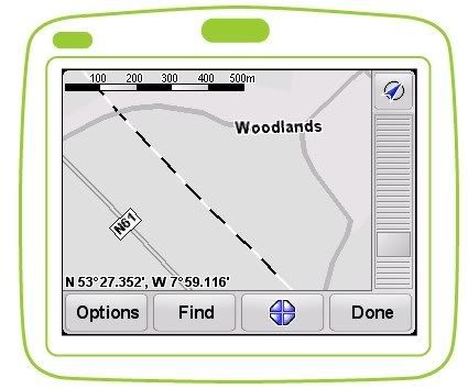
do a search for an estate in Co.Westmeath, called the " WOODLANDS"....
its out the Roscommon road a few miles from Athlone, near the Hudson Bay Hotel in BARRYMORE....... If i close in on the map its there! BUT if i do a search it returns " No street "
let me pull up a screenshot to exhibit this.....
WHY CANT I find this estate on a search ???????????????????????????????????
See next post......0 -
Can you advise me on this one TTI please ?
Am i using the software wrongly? or am i expecting too much?
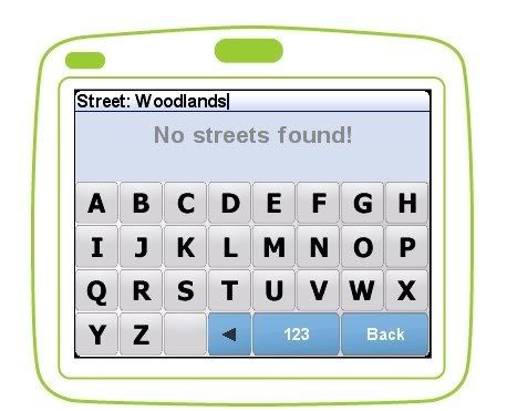
i would have thought that when i search for " woodlands" that i would get many results......especially as i have Irl & UK maps. However as per screenshot, im shocked.
my airis will reveal this estate o a search for " woodlands" cause it returns 177 matches across the UK & irl.....thanks to , ah you know already!
What is the story???
its so infuriating......after all its only how TT have scripted their search strings in the software coding. STOP following the autocomplete approach and instead allow a full search string followed by an enter command to initiate the search....0 -
? anything stirrin?
Ps
im givin up on this thread shortly, cause it may seem im whinging....but its SO annoying that it could be so right, given feedback from users. The mapshare / mapupdate facilty , while seemingly being advantageous, is merely dressage!
PLEASE build on the points raised by all in previous posts and concentrate on the mapping.....thats what makes the day.
all im getting from connecting the TT to the mac at present is an overnight charge....lets get more please!
happy new year to all. im off to igo8 ! [thanks to "thenobody" ]0 -
Am i using the software wrongly? or am i expecting too much?
i would have thought that when i search for " woodlands" that i would get many results......especially as i have Irl & UK maps. However as per screenshot, im shocked.
Just tried navigating to there and it found it no problem. Nav to -> Address -> Street & house number -> Barrymore (County Roscommon) -> Woodlands -> house #.
At least it appears to be the same place as on your screenshots ?0 -
bought a go 930 over very disapointed in the maps for ireland eg the blanchardstown shopping centre is not on it.The dublin map I recently bought which is based on the ordinance survey shows itTomTom Ireland wrote: »Hi All,
I represent TomTom in Ireland and would be keen to get feedback in relation to mapping, POI, user experience detail etc. Please post any map issues you may have with mapping also so that I can work to resolve these.
Just to point out also, we have an additional 20k new POI locations due to be uploaded to TomTom Home in the near future - will keep you posted on when etc.
Thanks and look forward to comments... good & bad!0 -
Eirlink thaks for all your contributions but keep an eye on this thread. I use everything IGO, Garmin, Co-Pilot, Destinator and Tomtom and its a real pity that Tomtom didnt stick with Navteq but anyway when they realise their mistake they will be back. I have to say that I use the Tomtom a lot and like it relative to the others except for the mapping so I will be watching the mapping issue very closely. Good luck0
-
0
-
-
-
-
Advertisement
-
-
Just had a look at Googlemaps, which shows you what you'd get with a TomTom.
The SuperQuinn in Blanchardstown is marked down as the Roselawn shopping center, while the real Roselawn goes unnamed.
To be fair, they've only been around 20 years, or there abouts.
I'm a big TomTom fan, but their mapping is pretty lousy, doesn't even have really established industrial estates, e.g. the BallyCoolin one near Blanch.0 -
bought a go 930 over very disapointed in the maps for ireland eg the blanchardstown shopping centre is not on it.The dublin map I recently bought which is based on the ordinance survey shows it
Hi, have you updated your map as per the 30 day guarantee? This won't correct Blanchardstown SC but if you have other issues they should be resolved.0 -
Just had a look at Googlemaps, which shows you what you'd get with a TomTom.
The SuperQuinn in Blanchardstown is marked down as the Roselawn shopping center, while the real Roselawn goes unnamed.
To be fair, they've only been around 20 years, or there abouts.
I'm a big TomTom fan, but their mapping is pretty lousy, doesn't even have really established industrial estates, e.g. the BallyCoolin one near Blanch.
Glad you are a fan and sorry to hear that you find the maps to be lousy. I appreciate that there are mapping issues, as per detail on this thread and also in my own driving experience. To be fair though I don't find that many and do drive a lot around Ireland - yes, there are certainly some, but that applies to all at the moment, none can claim perfection - but we are working on that! The town-land issue is definitely a thorn in my side...
Blanch SC is included in the new POI set. Not sure about some of the Industrial Estates but will check them.
I can't make the POI set available as such yet, but I may *test* a few through the board... PM for detail.0 -
well its great to see you have not abandoned us TTi......
glad youre back , and happy new year!
now for the serious stuff.
1. we will give you our tomtom home email logins so you can instruct amsterdam to PUSH out the latest and greatest to your fellow boardsies....
2. send the dutch an email to push out the Q4 2008 NAVTEQ maps to us....and before you tell us you only do TA, we dont believe you! TA have navteq q4 2008 ! you know im right!!
3. give us a more detailed response re irish townlands and when they will feature?
4. lastly,and im looking forward to this??
do a search for an estate in Co.Westmeath, called the " WOODLANDS"....
its out the Roscommon road a few miles from Athlone, near the Hudson Bay Hotel in BARRYMORE....... If i close in on the map its there! BUT if i do a search it returns " No street "
let me pull up a screenshot to exhibit this.....
WHY CANT I find this estate on a search ???????????????????????????????????
See next post......
Ok...
First of all, map upgrades are not out of the question for assistance I have got here. I am actually going to request that!
Townlands - I have a meeting with TeleAtlas on the 28th and will get some more answers then.
I see you got a reply where the area was found, does that answer that aspect or is it still not showing up for you?
POI - PM!0 -
TomTom Ireland wrote: »Hi, have you updated your map as per the 30 day guarantee? This won't correct Blanchardstown SC but if you have other issues they should be resolved.
Is anyone else having problems downloading maps from the ' Latest Map guarantee ' at the moment, havent been able to access this for a while now. Seems like quite a common problem, getting an error complaining about the server being down :
ERROR: 203/#https://home.tomtom.com/shop/latestMapGuarantee: Error from server: There is a problem on the TomTom HOME server, please try again later.
There is a problem on the TomTom HOME server, please try again later.
Server function called: latestMapGuarantee
Error code: 2030 -
Hi There, Bought a Go 730 a few months ago as I felt I needed to upgrade my old LIDL bought sat nav. I have to say, the Routing in the tomtom is very good, it does take you the fastest route according to the maps it has, but the maps do let it down. it does try to get the best route, but if sections of the country are missing, it can't navigate correctly. A whole section of the roads around Halfway village (Between Cork city and bandon) are missing, about 5 square miles!!! (And i'll be dammed if I am going submit all these roads as corrections for tomtom when they should be including these roads themselves).
And more of a issue, I bought the sat nav, when I plugged it in to my computer (An apple) and the software didn't look anything like tomtom advertised, and could not upgrade the maps, I then had to borrow a friends pc, install the software, then it said my maps were 3 quarters old. And I had to pay 54 euro to upgrade them, and then saw very little difference. Very dissappointed.
I am now using 2 sat navs in my car every day, the tom tom for routing, and the old cheap one to check that the tomtom is not missing roads and a shorter route may be available.
Please - Tomtom, get your act together, if you will not go back to navteq, please get people out on the roads, map the roads correctly, and save us all the hassle of doing the work for you, and then having to pay for upgrades that we have submitted months earlier.
Oh, and before I finish my rant - One more correction for tomtom, the location of junctions, when you travel west of cork city, pretty much all the junctions on the minor roads are about 50 meteres out.0 -
Is anyone else having problems downloading maps from the ' Latest Map guarantee ' at the moment, havent been able to access this for a while now. Seems like quite a common problem, getting an error complaining about the server being down :
ERROR: 203/#https://home.tomtom.com/shop/latestMapGuarantee: Error from server: There is a problem on the TomTom HOME server, please try again later.
There is a problem on the TomTom HOME server, please try again later.
Server function called: latestMapGuarantee
Error code: 203
tried that link as well, same error, cant find link on website either 0
0 -
where is tomtom ireland ?????
i seem to recall that he promised a major POI for ireland SOON!
and that he was in " talks " with amsterdam re getting the townlands issue sorted!
anyway for whats its worth, im gone from tomtom forever.....to igo.....and im only prodding this thread for everyone elses benefit!
Advice for tti
have a serious look at igo 8......its actually THE best satnav product on the market currently IMO.....it picks up on the shortcomings of garmin and tomtom and fills in the blanks.
tt need to do a LOT of market research ....and i WAS serious when i asked TTI to involve us boardsies in beta testing their products......but i guess they know more about sat nav than do ..........;)0 -
Advertisement
-
where is tomtom ireland ?????
i seem to recall that he promised a major POI for ireland SOON!
and that he was in " talks " with amsterdam re getting the townlands issue sorted!
anyway for whats its worth, im gone from tomtom forever.....to igo.....and im only prodding this thread for everyone elses benefit!
Advice for tti
have a serious look at igo 8......its actually THE best satnav product on the market currently IMO.....it picks up on the shortcomings of garmin and tomtom and fills in the blanks.
tt need to do a LOT of market research ....and i WAS serious when i asked TTI to involve us boardsies in beta testing their products......but i guess they know more about sat nav than do ..........;)
Where have I been? Working to correct the issues!")
Ok, I have had several meetings with Tele Atlas and various product people in Amsterdam and discussed problems raised both here and from other sources. The main problem would appear to be Townlands as present. I appreciate there have been issues raised on POI's such as Blanchardstown Centre etc but these have been corrected in the new POI set - I have this and it works well, the reason for the delay in making more widely available is that it has to be tested for a while first and I also needed a file for each device available, rather than just one file for all - I now have these files and will send download links and install instructions for those who wish to test them.
I know the Dublin to Cork road had been a problem but this seems to be almost completely fixed as per the last map release - still a portion missing but that opened after our last release sometime in December to my knowledge.
So, right now I'm at the stage where I'm feeding back ultra-priority issues to TA to have fixed for the next map release ideally. The main area I have highlighted as per this thread is townlands and also spelling errors which obviously result in navigation problems. There are some major roads as per the Cork road that need updating but does anyone know of further major road issues they would like to highlight to me?0


Advertisement