Advertisement
If you have a new account but are having problems posting or verifying your account, please email us on hello@boards.ie for help. Thanks :)
Hello all! Please ensure that you are posting a new thread or question in the appropriate forum. The Feedback forum is overwhelmed with questions that are having to be moved elsewhere. If you need help to verify your account contact hello@boards.ie
Hi there,
There is an issue with role permissions that is being worked on at the moment.
If you are having trouble with access or permissions on regional forums please post here to get access: https://www.boards.ie/discussion/2058365403/you-do-not-have-permission-for-that#latest

My interchange designs.

2

Comments

  • Registered Users, Registered Users 2 Posts: 9,251 ✭✭✭sdanseo


    nordydan wrote: »
    I don't think this junction is upgradable in fariness, does the luas not need a very long incline and decline for its potential bridge?

    Not really...look at the ramp in town at Peter Place. Very steep indeed - not a fan of it though :P


  • Registered Users, Registered Users 2 Posts: 1,639 ✭✭✭Zoney


    I think you couldn't possibly manage to get the north/south mainline up and over the east/west, it would have to be the other way round. Due to the topography and the insane gradient you would have on the tunnel side (absolutely impractical - it would make the R526 overbridge on the SRR in Limerick look like the level!). I would imagine though that with the other way round, fitting in the slips would be more awkward.

    While the arrangement of slip roads in mysterious's drawing may be somewhat attractive from above (in terms of not looking too incoherent or needing loads of bridges), that's about all that can be said.

    Although I don't consider nordydan's effort that realistic either - his contribution that one should focus on making N25 and N8 continuous is interesting, but I wonder is it warranted? What are the busiest traffic flows on the junction? They are the ones that should probably be accommodated most rather than a theoretical N8/N25 continuity OR the North/South continuity.

    I'm not suggesting doodling junction layouts is completely worthless - it is of some help in discussing them and dredging up the various issues that would be involved in a junction redesign. Plus it is presumably interesting too for those drawing them!


  • Registered Users, Registered Users 2 Posts: 9,251 ✭✭✭sdanseo


    Irjudge1 wrote: »
    I need some help here. For clarity I'm going to ignore the fact that orientation of the drawing is 180 Degrees out.

    What does that matter? The before and after are both orientated the same, that's all that matters. He's not expected to be an architect.


  • Registered Users, Registered Users 2 Posts: 1,412 ✭✭✭Road-Hog


    sdonn wrote: »
    What does that matter? The before and after are both orientated the same, that's all that matters. He's not expected to be an architect.

    North should always 'point up' as in go from bottown of page to top of page in the majority of plan type drawings.


  • Posts: 31,118 ✭✭✭✭ [Deleted User]


    Road-Hog wrote: »
    North should always 'point up' as in go from bottown of page to top of page in the majority of plan type drawings.
    For the purpose of these drawings I don't think it really matters as long as the destinations are marked.


  • Registered Users, Registered Users 2 Posts: 1,108 ✭✭✭nordydan


    There are some on this forum that seem to think you shouldn't even attempt to suggest a junction redesign without being a chartered civil engineer and producing a 300 page EIS yourself. :confused:

    I'd rather see somebody suggest an alternative design, even if its unviable, rather that sit and snipe from the sidelines (often with a clear lack of ideas from their own). These drawings are done on MS Paint ffs, no-one is epxecting the Nobel prize for engineering. Fair play to anyone who at least gave it a lash. I spent a good 10 seconds on my effort. Ever tried designing a junction with a mouse and SM paint?? That's why God invented AutoCAD.:cool:

    By the way the N25 north (through the JLT) to N8 west may be the biggest movement now from that direction, but if the Cork NRR is built a lot of traffic may head up the N8 to use this, so maybe existings orientations are correct. Just a thought;)


  • Banned (with Prison Access) Posts: 25,234 ✭✭✭✭Sponge Bob


    nordydan wrote: »
    If the Cork NRR is built a lot of traffic may head up the N8 to use this, so maybe existings orientations are correct. Just a thought;)

    Compensated for by southbound traffic from Fermoy that no longer uses Dunkettle. The NRR will end at the N20 though .....not around Ballincollig as I now understand it .


  • Registered Users, Registered Users 2 Posts: 19,053 ✭✭✭✭murphaph


    nordydan wrote: »
    There are some on this forum that seem to think you shouldn't even attempt to suggest a junction redesign without being a chartered civil engineer and producing a 300 page EIS yourself. :confused:

    I'd rather see somebody suggest an alternative design, even if its unviable, rather that sit and snipe from the sidelines (often with a clear lack of ideas from their own). These drawings are done on MS Paint ffs, no-one is epxecting the Nobel prize for engineering. Fair play to anyone who at least gave it a lash. I spent a good 10 seconds on my effort. Ever tried designing a junction with a mouse and SM paint?? That's why God invented AutoCAD.:cool:

    By the way the N25 north (through the JLT) to N8 west may be the biggest movement now from that direction, but if the Cork NRR is built a lot of traffic may head up the N8 to use this, so maybe existings orientations are correct. Just a thought;)
    From my own perspective the only problem I have is the OP's virulent attacks on unknown engineers (and anyone who suggests the engneers had issues to deal with) for dealing with unknown geological problems on an unknown budget in an unknown way. The OP simply shouldn't be lambasting people when he has NONE of the facts to hand. Doodling away is fine and good fun, but coupled with the "I can do it so why can't the NRA engineers?" line it's something more and a little tiresome (and childish) when every single post from the OP is phrased like this.


  • Registered Users, Registered Users 2 Posts: 1,108 ✭✭✭nordydan


    Sponge Bob wrote: »
    Compensated for by southbound traffic from Fermoy that no longer uses Dunkettle. The NRR will end at the N20 though .....not around Ballincollig as I now understand it .

    Here's the rest of it:

    http://www.corkrdo.ie/files/CNRR%20Brochure-Preferred%20Route%20Part%201.pdf


  • Advertisement
  • Closed Accounts Posts: 5,133 ✭✭✭mysterious


    murphaph wrote: »
    From my own perspective the only problem I have is the OP's virulent attacks on unknown engineers (and anyone who suggests the engneers had issues to deal with) for dealing with unknown geological problems on an unknown budget in an unknown way. The OP simply shouldn't be lambasting people when he has NONE of the facts to hand. Doodling away is fine and good fun, but coupled with the "I can do it so why can't the NRA engineers?" line it's something more and a little tiresome (and childish) when every single post from the OP is phrased like this.


    lol. Somebody is envious, no surprise there.


    But to debunk your nonsense and your petty dig. I don't think "I can and only do it". - "I don't think I'm better". " I also said my designs are not perfect. I can take constructive criticism, you murpaph as always show to have a little understanding of the actual skill I have in this subject. I would even say you would miss this in a lot of people.


    I have been away from this thread for a while. I'm constantly drawing new designs of interchanges. I never said I was better than anyone else. I didn't look for compliments. I'm just doing it.


    I am someone who is putting my ideas and work out there. I couldn't give a blimey what you think.


    Something you have issues with. As your posts clearly states. Nobody is lambasting people only you. I stil think the NRA are goons. I won't deny that nor would else dissagree with me on that.


  • Registered Users, Registered Users 2 Posts: 19,053 ✭✭✭✭murphaph


    mysterious wrote: »
    lol. Somebody is envious, no surprise there.


    But to debunk your nonsense and your petty dig. I don't think "I can and only do it". - "I don't think I'm better". " I also said my designs are not perfect. I can take constructive criticism, you murpaph as always show to have a little understanding of the actual skill I have in this subject. I would even say you would miss this in a lot of people.


    I have been away from this thread for a while. I'm constantly drawing new designs of interchanges. I never said I was better than anyone else. I didn't look for compliments. I'm just doing it.


    I am someone who is putting my ideas and work out there. I couldn't give a blimey what you think.


    Something you have issues with. As your posts clearly states. Nobody is lambasting people only you. I stil think the NRA are goons. I won't deny that nor would else dissagree with me on that.
    If people agree with this nonsense they'll click to support it, if not they'll either click to support what I said or click below this post to show that they do not agree with the bulk of what you say and they do believe in reasoned debate (as opposed to hysterical replies such as "I waaaaaaaaaaaaaaant my blue motorway" and other such cobblers. Let the people start clicking.......


  • Registered Users, Registered Users 2 Posts: 1,412 ✭✭✭Road-Hog


    murphaph wrote: »
    From my own perspective the only problem I have is the OP's virulent attacks on unknown engineers (and anyone who suggests the engneers had issues to deal with) for dealing with unknown geological problems on an unknown budget in an unknown way. The OP simply shouldn't be lambasting people when he has NONE of the facts to hand. Doodling away is fine and good fun, but coupled with the "I can do it so why can't the NRA engineers?" line it's something more and a little tiresome (and childish) when every single post from the OP is phrased like this.

    Being farily new to this forum, who is OP or is it an abreviation for something?


  • Registered Users, Registered Users 2 Posts: 19,053 ✭✭✭✭murphaph


    Road-Hog wrote: »
    Being farily new to this forum, who is OP or is it an abreviation for something?

    It's short for "original poster", in this case "mysterious". :)


  • Closed Accounts Posts: 254 ✭✭The Word Is Bor


    nordydan wrote: »
    Ever tried designing a junction with a mouse and SM paint?? That's why God invented AutoCAD.:cool:
    Actually MXRoad is used to design the roads but it is a (substantial) bolt on to CAD. Autodesk have brought out a Civil 3D package which can do something similar to MX.
    nordydan wrote:
    By the way the N25 north (through the JLT) to N8 west may be the biggest movement now from that direction, but if the Cork NRR is built a lot of traffic may head up the N8 to use this, so maybe existings orientations are correct. Just a thought;)

    I would think that the biggest movement through Dunkettle would be N25 east to N25 south (and vice versa).


  • Registered Users, Registered Users 2 Posts: 1,108 ✭✭✭nordydan


    murphaph wrote: »
    It's short for "original poster", in this case "mysterious". :)

    Or "old pal" in Murphaph's case, mysterious is his old pal :D


  • Advertisement
  • Registered Users, Registered Users 2 Posts: 1,108 ✭✭✭nordydan


    Actually MXRoad is used to design the roads but it is a (substantial) bolt on to CAD. Autodesk have brought out a Civil 3D package which can do something similar to MX.
    Yes indeed, the Autodesk (AutoCAD) product range has diversified considerably over the last 5 years or so. Thats for the info

    I would think that the biggest movement through Dunkettle would be N25 east to N25 south (and vice versa).
    Aha I was right, I knew that ten seconds wasn't wasted :cool:


  • Closed Accounts Posts: 5,133 ✭✭✭mysterious


    murphaph wrote: »
    If people agree with this nonsense they'll click to support it, if not they'll either click to support what I said or click below this post to show that they do not agree with the bulk of what you say and they do believe in reasoned debate (as opposed to hysterical replies such as "I waaaaaaaaaaaaaaant my blue motorway" and other such cobblers. Let the people start clicking.......

    Bla bla bla bla bla

    You always have to put in a dig.

    You don't surprise me:D How many times have I proven you wrong on many subjects on roads in general. ? It seems this is your only way getting back at me.

    Yeah whatever.:D


  • Closed Accounts Posts: 5,133 ✭✭✭mysterious


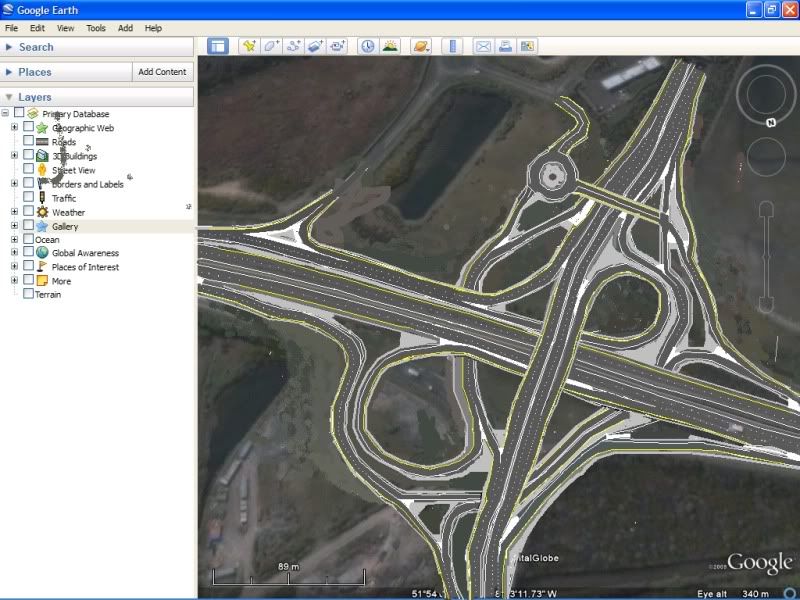
    Ok I've come up with the finished layout of the N25 it's even better than my previous one. Where I forgot to put in the N8 city to Jack tunnel loop in correctly.

    Also I've incoporated aspect/altitude more closely.


  • Closed Accounts Posts: 5,133 ✭✭✭mysterious


    untitledl-4.jpg


    All movements in every direction completely freeflow.
    • Modified the N8(Dublin to city N8) to go under the N8 and proceed east.
    • An extra bridge
    • The bridge that carried local traffic under the the tunnel road is now an overbridge (since the tunnel road drops significantly)
    What do you all think??:)


  • Registered Users, Registered Users 2 Posts: 19,053 ✭✭✭✭murphaph


    mysterious wrote: »
    untitledl-4.jpg


    All movements in every direction completely freeflow.
    • Modified the N8(Dublin to city N8) to go under the N8 and proceed east.
    • An extra bridge
    • The bridge that carried local traffic under the the tunnel road is now an overbridge (since the tunnel road drops significantly)
    What do you all think??:)
    The climb up the gradient from the tunnel exit to N8 northbound would not be achievable by many vehicles at all.

    That's the upermost level of a stacked roundabout down to a sub-surface tunnel (app 25 metres I reckon~5m operational bridge height + 1m for each bridge deck) in the space of what? 150 metres?? (according to the scale on the google overlay). I reckon it's getting on for at least a 20% gradient-not something you'd ever see on a motorway type road.

    You should take up rollercoaster design though.


  • Advertisement
  • Registered Users, Registered Users 2 Posts: 1,412 ✭✭✭Road-Hog


    murphaph wrote: »
    The climb up the gradient from the tunnel exit to N8 northbound would not be achievable by many vehicles at all.

    That's the upermost level of a stacked roundabout down to a sub-surface tunnel (app 25 metres I reckon~5m operational bridge height + 1m for each bridge deck) in the space of what? 150 metres?? (according to the scale on the google overlay). I reckon it's getting on for at least a 20% gradient-not something you'd ever see on a motorway type road.

    You should take up rollercoaster design though.

    Concurr with Murphaph on this one, the layout looks workable in x-y plane but I think mr. mysterious should seriously think about considering the z dimension and some basic road geometry, I think the max desirable gradient is 5-6%. Maybe the tunnel could be elevated and converted into a bridge over the lee?


  • Closed Accounts Posts: 5,133 ✭✭✭mysterious


    The distance from the tunnel to the N25 bridge is 0.39km.The alittude raises from 2meteres to 7 metres (the N25 overbridge)

    Can someone do that math (I'm not good at this part)

    Btw the graidient would work out from the N25 up the N8 as the altitude raises anyway. So my bridge Bridge design would be fine from the N25 anyway.


    Couldn't they sink the N25 bridge by 1 metre?


  • Closed Accounts Posts: 5,133 ✭✭✭mysterious


    The M2 from Belfast to past Whitewell to the hill section, it climbs at a gradient of up to 1 in 15.


  • Closed Accounts Posts: 3,082 ✭✭✭Chris_533976


    If you get bored can you do a version with the Tunnel - Dublin movements going under the N25?? Other than mucking about with some slips that should be do-able.


  • Registered Users, Registered Users 2 Posts: 19,053 ✭✭✭✭murphaph


    mysterious wrote: »
    The distance from the tunnel to the N25 bridge is 0.39km.The alittude raises from 2meteres to 7 metres (the N25 overbridge)
    Where are you getting these figures? You are saying that there is a slope UP into the tunnel mouth from the roundabout with those figures because the operational height of a motorway bridge is app. 5m and the deck is app. 1m thick=6 metres from upper road surface to lower. You are saying that the height from the upper road surface to the lower is 5 metres (too low-trucks would be striking the bridge every day as the operational height would be ca. 4m!!) OR you are suggesting that the road actually slopes UP into the tunnel mouth from the junction!! Neither of these are true so I ask again-where did you get these elevations?

    Also-the distance from the tunnel to the N25 is not the relevant distance because the bridge (proposed N8 flyover over N25) abutments would need to be well clear of the N25 (obviously) so you can't start coming down until well clear of the N25 mainline.

    Ok, even if that were correct-you propose adding ANOTHER bridge over the N25one which would mean at least a further 6 metres (5metre operational height + 1 metre for the bridge deck and road surface).
    mysterious wrote: »
    Can someone do that math (I'm not good at this part)
    Can we verify your claimed elevations before we start computing the gradient PLEASE!
    mysterious wrote: »
    Couldn't they sink the N25 bridge by 1 metre?
    How?

    My own opinion on this junction is that it cannot be freeflowed in all movements due to the proximity of the tunnel and it will have to be sorted out by shifting part of the junction northwards. It may never be fully freeflowed and I'd suggest the least important movement should be the N8 into the city centre, especially post CNRR.


  • Registered Users, Registered Users 2 Posts: 19,053 ✭✭✭✭murphaph


    mysterious wrote: »
    The M2 from Belfast to past Whitewell to the hill section, it climbs at a gradient of up to 1 in 15.
    Your proposed gradient is much steeper than that though and you are proposing such a steep gradient at the mouth of an underwater tunnel! 1 in 15 is 6.6%-and that is known as being (I believe) one of the steepest sections of motorway in the UK! You propose a much steeper gradient for the tunnel->N8 movement. This is the mainline we are talking about-it wouldn't do to have lorries crawling up there in 1st gear!


  • Closed Accounts Posts: 6,093 ✭✭✭Amtmann


    Could you put the M8 underneath the N25?


  • Registered Users, Registered Users 2 Posts: 9,251 ✭✭✭sdanseo


    Furet wrote: »
    Could you put the M8 underneath the N25?

    Not without excavating a few million tonnes of earth and horrific disruption.


  • Registered Users, Registered Users 2 Posts: 19,053 ✭✭✭✭murphaph


    Furet wrote: »
    Could you put the M8 underneath the N25?
    This would be the only way to do it if it's even possible. The gradient from a sub-surface N8 to the tunnel should be ok but I doubt it would then be possible to free flow the other movements. Really the CNRR needs extending to Ballincollig to provide a complete ring, then freeflowing all the movements at Dunkettle would be less important.


  • Registered Users, Registered Users 2 Posts: 83 ✭✭Enbee


    Have a go at the N9/N24/N25 Grannagh interchange mysterious.


  • Advertisement
  • Closed Accounts Posts: 1,735 ✭✭✭Irish and Proud


    Furet wrote: »
    Could you put the M8 underneath the N25?

    ...maybe the M8 could pass over the current interchange from the Glanmire Bypass (as Mysterious has proposed), but divert it into a mainline loop (like the Lincoln Tunnel Entrance (Highway 495 into Manhattan) on the New Jersey side of the Hudson) in order to achieve the necessary gradient. I know that some of the freeflow slips would have to be re-worked, but IMO it's worth a try!

    Regards!


  • Registered Users, Registered Users 2 Posts: 83 ✭✭Enbee


    You'd probably need a gigantic loop over marshy land to do that though - could be rather expensive.

    Would it not be simpler to just eliminate local access (with Little Island accessed from the N25) and maybe have something like the N4-M50 interchange instead?


  • Closed Accounts Posts: 3,082 ✭✭✭Chris_533976


    Thats easy with an N24 - M8 trumpet and an N25/8/road into Waterford 3-level stack :D

    I reckon a 3 level stack would be ok there.


  • Registered Users, Registered Users 2 Posts: 83 ✭✭Enbee


    Thats easy with an N24 - M8 trumpet and an N25/8/road into Waterford 3-level stack :D

    I reckon a 3 level stack would be ok there.

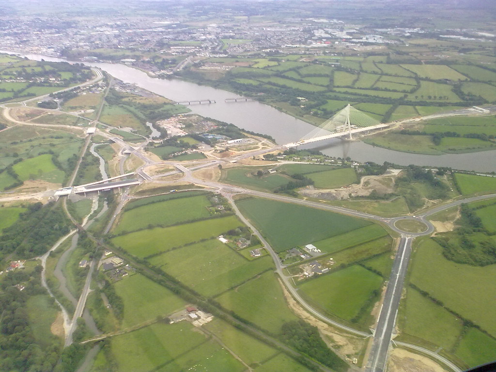
    I still can't understand why it wasn't designed that way to begin with. When I first saw the designs I thought there might have been difficult terrain preventing it but was then flabbergasted when I saw aerial photos of it.

    If money was an issue then couldn't the intersection have been designed so that the third level of the stack (M9 mainline?) could have been added at a later date when traffic numbers made it an absolute necessity?

    Even more bizarre considering the N25 could be redesignated as motorway. Where else in Europe could a motorway terminate a few hundred metres from another and then proceed as a roundabout laden DC?


  • Registered Users, Registered Users 2 Posts: 1,108 ✭✭✭nordydan


    The reason there is no N24/M9 freeflow is that the N24 part of the N24/M9 roundabout was not originally designed to be the final N24, but a link road from the existing N24 to a new build N24, which was to meet at this roundabout. As to what design it would have. I have no idea.

    http://www.nra.ie/RoadSchemeActivity/KilkennyCountyCouncil/N24MooncoinBypassWesternCorridor/SchemeName,16510,en.html

    http://www.kilkennycoco.ie/resources/eng/Services/mooncoinmap.gif

    On the other hand, the M9(N9) N25 junction is a disgrace.


    If I were to wager a bet I would imagine that when(if) the N24 Mooncoin Bypass (cool name) is built, it will meet at a GSJ, with the M9 mainline continuing underneath onto the N25 (M9 J13) where free flow slips may be added (but that's it)


  • Closed Accounts Posts: 5,133 ✭✭✭mysterious


    Enbee wrote: »
    Have a go at the N9/N24/N25 Grannagh interchange mysterious.


    If someone can find me a pic, then I will start at it straight away.


  • Registered Users, Registered Users 2 Posts: 83 ✭✭Enbee


    mysterious wrote: »
    If someone can find me a pic, then I will start at it straight away.

    Here it is ... in all its bizarre glory ;)

    3705487594_fd56322cf4_b.jpg


    M9 coming in from the bottom. N24 coming in from the right.


  • Closed Accounts Posts: 5,133 ✭✭✭mysterious


    I can't draw from that, its an awful angle. and the Ms Paint will not be able to come out right since MS pain is 2-D oreintated, The N24 is not really visilble, nor is the appropriate N24 exit can be put in.

    The Grannagh interhchage is just horrific to upgrada, (never mind trying to alter it on MS paint at that angle.


    Has anyone got a finished layout out?


  • Closed Accounts Posts: 3,082 ✭✭✭Chris_533976


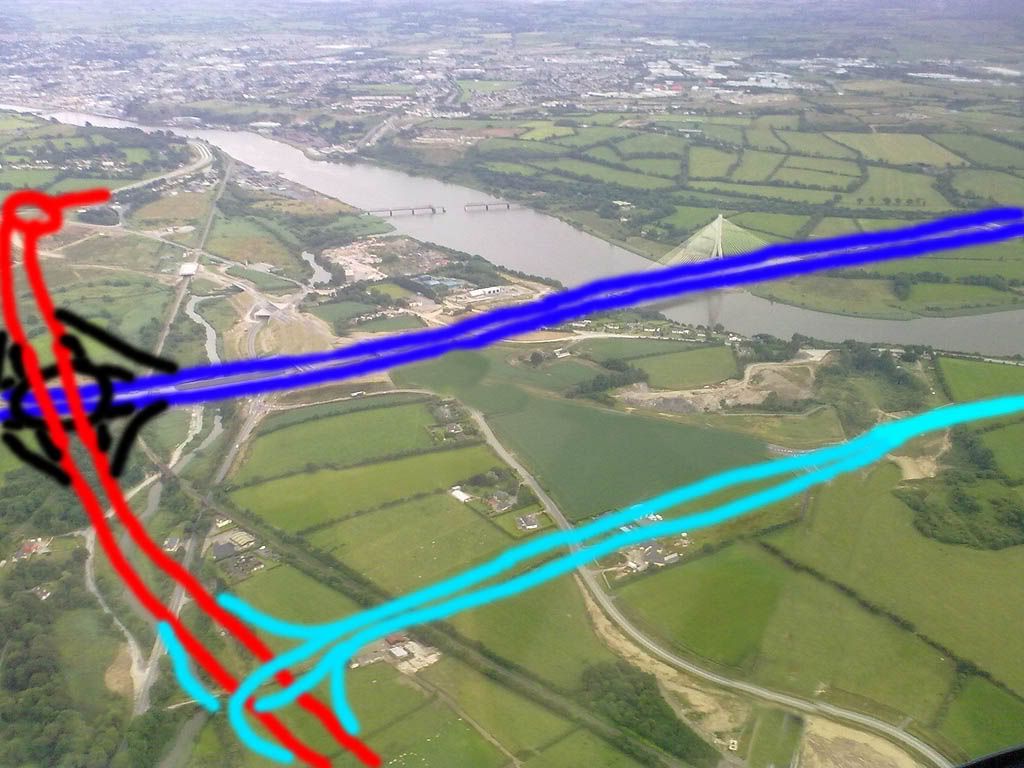
    Here.

    3705487594_fd56322cf4_bb.jpg

    Exact positioning would be different as everything had to fit on the screenshot (moving the N24/M8 junction further north for example).

    All this should be do-able though, and I'd move the toll booth further west also, as noone wants to crawl across the nice bridge.


    Edit: Jesus christ that looks like a drawing of someone doing things to themselves.


  • Advertisement
  • Registered Users, Registered Users 2 Posts: 1,297 ✭✭✭D.L.R.


    A simpler solution would be to re-route the N24 south along the R680 from Carrick, terminating at the western end of the WBP.

    There's no need for Carrick-Grannagh to be an N road, when a shorter route will exist between the two settlements.


  • Closed Accounts Posts: 5,133 ✭✭✭mysterious


    D.L.R. wrote: »
    A simpler solution would be to re-route the N24 south along the R680 from Carrick, terminating at the western end of the WBP.

    There's no need for Carrick-Grannagh to be an N road, when a shorter route will exist between the two settlements.


    omg.


    :rolleyes:


  • Moderators, Science, Health & Environment Moderators Posts: 5,246 Mod ✭✭✭✭spacetweek


    mysterious wrote: »
    omg.
    :rolleyes:
    Why the eye-roll? I agree with him.

    On my site I proposed bypassing the whole thing, though in retrospect this might be over-engineered. Plus it doesn't create an M9 mainline that leads into the city. You need to use the N25 to continue your journey.


  • Closed Accounts Posts: 3,082 ✭✭✭Chris_533976


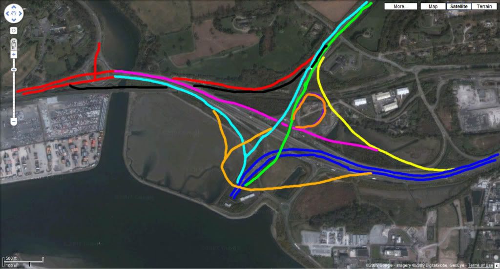
    Heres another hare brained scheme for Dunkettle. Unfortunately bloody Photoshop didnt preserve layers, so ideally the cyan line and green line (Dublin) are more flared to allow the black line to dip underneath the cyan one. This takes into account the plans to dump traffic lights on Glanmire, which actually makes this easier.

    Edit: The blue line (Tunnel - East) would be reasonably sunk throughout.

    dunkettle2.jpg

    God knows how they'd build it, but it would look pretty.

    Also to hell with ALL the local roads, theres plenty of alternate access (go to Little Island dammit).


  • Registered Users, Registered Users 2 Posts: 230 ✭✭johnbk


    I was at a public information meeting on the A5 yesterday. (I have posted info in a new A5 post eles where.) I was wondering if people could give me ideas for a junction for this project. Their current thinking is to have the new A5 run along the exising A5 and have some sort of junction with the existing Lifford road, then 500m further south have a roundabout where a new road will join in from Donegal N14/N15. Donegal will have to have another roundabout to the left of the big blue arrow where the N14 and the N15 will join together after they are upgraded. The main constaints are that the route of the proposed A5 cant really change as they have just decided this and to limit the number of bridges to two.
    3766873518_ce7d5f30c4_o.jpg

    My views are my own.


  • Closed Accounts Posts: 5,133 ✭✭✭mysterious


    dunkettle2-1.jpg


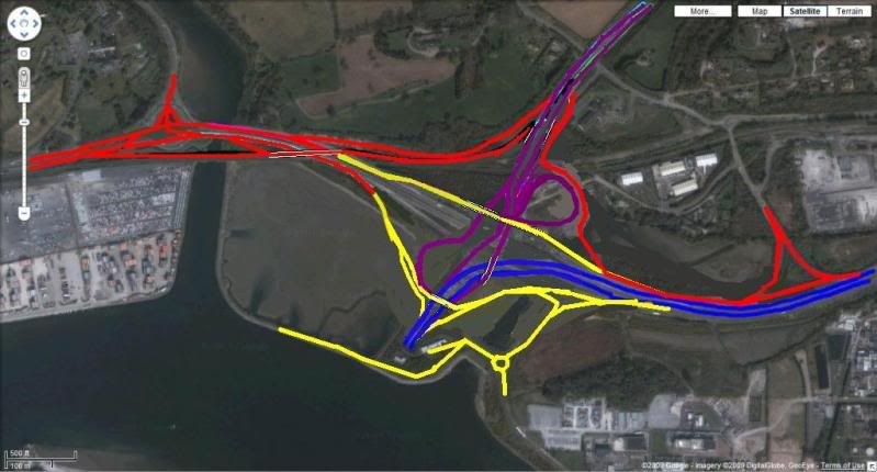
    I modified Chris design. This is the preferred design, but I didn't opt for this one merely because it would cost incredible amount of money and time. Not to mention completley ripping up the N25 mainline and roundabout.

    So I came up with a plan. For this road to become a reality.


    I marked the road into four phases.

    Phase 1 = red
    Phase 2 = Yellow
    Phase 3 = purple
    Phase 4 = BLue

    This means that it can be done in stages and there will be minimal disruptions as over time each phrase will free traffic up until it comes to the time of completely re-arranging the mainline from the tunnnel to the N25 (blue) off the roundabout.


    Phase one can easily start right noiw. (If they now see the potential to open the interchange entirely freeflowing in the foreseeable future.


  • Advertisement
  • Registered Users, Registered Users 2 Posts: 1,297 ✭✭✭D.L.R.


    spacetweek wrote: »
    Why the eye-roll? I agree with him.

    On my site I proposed bypassing the whole thing, though in retrospect this might be over-engineered. Plus it doesn't create an M9 mainline that leads into the city. You need to use the N25 to continue your journey.

    Re N24/25/M9 madness, they have rubber-stamped a similarly inefficient and ugly arrrangement for the N30-M11 link north of Enniscorthy, and again this involves a lesser N road (this time the N80) confusing what should be a simple straightforward link between two main primaries.

    This too happened because one half was designed before the other half. Unfortunately, saving a few aul quid still seems to trump maximum efficiency in this state of ours.


  • Closed Accounts Posts: 5,133 ✭✭✭mysterious


    D.L.R. wrote: »
    . Unfortunately, saving a few aul quid still seems to trump maximum efficiency in this state of ours.

    What are we saving money for?

    Get the deception, there is no money so lets save the money


    Where did the money go? It seems we still live in world where when money run out we don't operate at all.


    Funny that people don't get it.:D Don't respond to this message. Just "think for a while"


  • Registered Users, Registered Users 2 Posts: 1,297 ✭✭✭D.L.R.


    Even when we were rolling in it 10 years ago, FF were busy cutting corners to "save" cash. Its nothing to do with current economic situation. That's the way this govt operates in good times or bad. Catch the penny miss the pound. Self interest first, nation second.


  • Closed Accounts Posts: 5,133 ✭✭✭mysterious


    D.L.R. wrote: »
    Even when we were rolling in it 10 years ago, FF were busy cutting corners to "save" cash. Its nothing to do with current economic situation. That's the way this govt operates in good times or bad. Catch the penny miss the pound. Self interest first, nation second.

    This is how money operates,

    I bolded it.:)


  • Registered Users, Registered Users 2 Posts: 230 ✭✭johnbk


    What do you think of this junction arrangement?

    3769302911_9f65eb39b4_o.jpg

    My views are my own.


  • Advertisement
Advertisement