Advertisement
If you have a new account but are having problems posting or verifying your account, please email us on hello@boards.ie for help. Thanks :)
Hello all! Please ensure that you are posting a new thread or question in the appropriate forum. The Feedback forum is overwhelmed with questions that are having to be moved elsewhere. If you need help to verify your account contact hello@boards.ie

National Postcodes to be introduced

Options
189111314295

Comments

  • Registered Users Posts: 9,787 ✭✭✭antoinolachtnai


    jetpack101 wrote: »
    I agree ... but on the flip side, we could be going around in circles constantly putting up barriers and the end result is what we have now...... no post code or easy way to navigate to a location.

    While I do think that giving the government full access to the code could secure a system, it could be a recipe for disaster. You can be pretty sure that someone somewhere in the government departments will want to put there stamp on it and in the process completely mess up the system.

    I am not just urging care about the private sector plans.

    The government code, as envisaged, also has serious intellectual property issues.


  • Registered Users Posts: 265 ✭✭Sysmod


    I just tried that today.

    From Google maps I think my GPS coordinates are (52.69295, -6.218512)

    I could see my house using Loc8 (looks like the OSI maps) and got SMB-24-NL9

    The GO map was very smudgy (like Google) and I could not even find our hill lane on it!
    As close as I can get it is R2L DDXF

    Now is there any site where I can plug these two different codes in and get the distance between them and directions :-)


  • Registered Users Posts: 2,278 ✭✭✭mackerski


    jetpack101 wrote: »
    Also take the forum we are discussing this on. The internet and all it has to offer is a wonderful thing and not a government official in site :)

    I agree with your analogy, but not your conclusion. The Internet was designed and, as already mentioned, set free. It drifted unnoticed for a long while, during which time commercial bodies set up proprietary networks that became quite popular due to user-friendly (for the times) software and an unthreatening walled garden. I'm referring to companies like Compuserve and America Online, which the younger folk here, if they've heard of them, may believe to have been normal ISPs from the start, rather than having had to reinvent themselves as such once the market voted with its feet for Internet technology.

    The Internet prevailed because it was open and standards-based and because nobody could stop you from using it in novel and unexpected ways. In particular, nobody charged anybody for using the underlying technologies, even if they were doing so commercially or in bulk.

    I've been careful to exclude any issue of government control from the above, because as Antoin has pointed out, the government isn't so far proposing an unencumbered postcode either.


  • Closed Accounts Posts: 149 ✭✭jetpack101


    Del2005 wrote: »
    The US government invented the internet and then let it run free, but now they are trying to take control back.

    The US gov invented a communications tool to be used by the military.

    This was later changed and adapted to work over all networks by a collage then later the World wide web was invented or created by Tim Berners-Lee.

    What the US government started with was clunky and could only be used by very highly Trained individuals.

    It was only after the private sector got to it did it become a useful tool.


  • Registered Users Posts: 2,278 ✭✭✭mackerski


    jetpack101 wrote: »
    It was only after the private sector got to it did it become a useful tool.

    On the contrary - it was only after it had become a useful tool that the private sector got to it. They brought much to enhance the Internet, and indeed, much to drag it down to their level (cough, Flash, cough).

    My point being that some things only deliver their full potential when you give them away. The private sector was never going to create anything like the Internet as we know it. They had to see it work first and (in many cases) swallow the harsh reality that it was better than what they had come up with.

    This is a dilemma, because it's hard to find somebody to fund stuff that's both expensive and has to be given away. Nobody said this stuff was easy.


  • Advertisement
  • Registered Users Posts: 8,779 ✭✭✭Carawaystick


    jetpack101 wrote: »
    What the US government started with was clunky and could only be used by very highly Trained individuals.

    It was only after the private sector got to it did it become a useful tool.

    I didn't think CERN was the private sector, who Tim Lee worked for creating the www


  • Closed Accounts Posts: 13,993 ✭✭✭✭recedite


    The cheapest and best outcome for the taxpayer is probably for the government to buy out the most successful privately developed postcode, and then set it free.


  • Registered Users Posts: 2,278 ✭✭✭mackerski


    recedite wrote: »
    The cheapest and best outcome for the taxpayer is probably for the government to buy out the most successful privately developed postcode, and then set it free.

    But how do you measure success? Consumer uptake? Consumers are not likely to value the same things the government has on its shopping list.


  • Registered Users Posts: 369 ✭✭Empire o de Sun


    Do we need a code to find a needle in a field?

    Post codes do not need to be complicated. Most countries do with a 4 or 5 digit code.

    2_digit_postcode_australia.png

    German_postcode_information.png


  • Posts: 31,118 ✭✭✭✭ [Deleted User]


    Do we need a code to find a needle in a field?

    Post codes do not need to be complicated. Most countries do with a 4 or 5 digit code.


    Depends whether you want to find the address or just the area!


  • Advertisement
  • Registered Users Posts: 43 esquilax


    Depends whether you want to find the address or just the area!

    What surprises me about this thread, or the part of it I've been arsed to read through (roughly the latter half) is that nobody has considered that the primary purpose of a postcode is to facilitate the automatic sorting of post - the purpose for which postcodes existed in many parts of the world before satellite navigation was even being considered as a concept.

    After the UK created their postcode system, the Royal Mail realised that it was no longer fit for its primary purpose and a second, completely separate postcode system was created (the Mailsort system). This is the mysterious number that often appears on the envelope of utility bills and other post from bulk senders in the UK.

    They receive a large discount for supplying their mail to Royal mail sorted via this system. There is no discount whatsoever for sorting it alphanumerically by the actual public postcode, which along with a house number can deliver the kind of directions to someone's front door that everyone seems to be looking for from any Irish system.

    This is a nice feature by all means, but consider how often you want your sat nav unit to bring you to unfamiliar address, versus how often you receive a letter in the post.

    I just hope the developers of the Go and Loc8 systems spent as much time consulting with An Post as they evidently have with makers of sat nav units because the government will ultimately chose a postcode system that helps deliver post under the system currently in place. A grid reference, or any alphanumeric recoding of a grid reference, doesn't.


  • Posts: 31,118 ✭✭✭✭ [Deleted User]


    esquilax wrote: »
    What surprises me about this thread, or the part of it I've been arsed to read through (roughly the latter half) is that nobody has considered that the primary purpose of a postcode is to facilitate the automatic sorting of post - the purpose for which postcodes existed in many parts of the world before satellite navigation was even being considered as a concept..

    You're correct in saying that a postcode is for sorting mail. This thread has expanded into (precisly) locating addresses for the delivery of "stuff", any logistics company that uses any of the systems described here would still have to overlay their distribution network onto it to determine which depot and which vehicle will do the delivery.


  • Closed Accounts Posts: 13,993 ✭✭✭✭recedite


    mackerski wrote: »
    But how do you measure success? Consumer uptake? Consumers are not likely to value the same things the government has on its shopping list.
    Politicians value popularity above all else, so consumer uptake would seem to be a good all round measure of success.
    Apparently Minister Ryan wants a location code superimposed on top of an area code. The politicians fear that consumers will resist an abstract code, and they think recognisable prefixes are necessary, whether relating to a city as with the UK postcodes, or the county as with our vehicle number plates.
    IMO politicians usually underestimate the man in the street, whereas the man in the street tends to overestimate the capabilities of politicians.

    I think An Post do already have a proprietary automated mail sorting code which is not released to the general public. Perhaps we should be referring here to a "location code" rather than a "postcode", bearing in mind the trend towards liberalisation of postal services.


  • Moderators, Science, Health & Environment Moderators Posts: 5,034 Mod ✭✭✭✭spacetweek


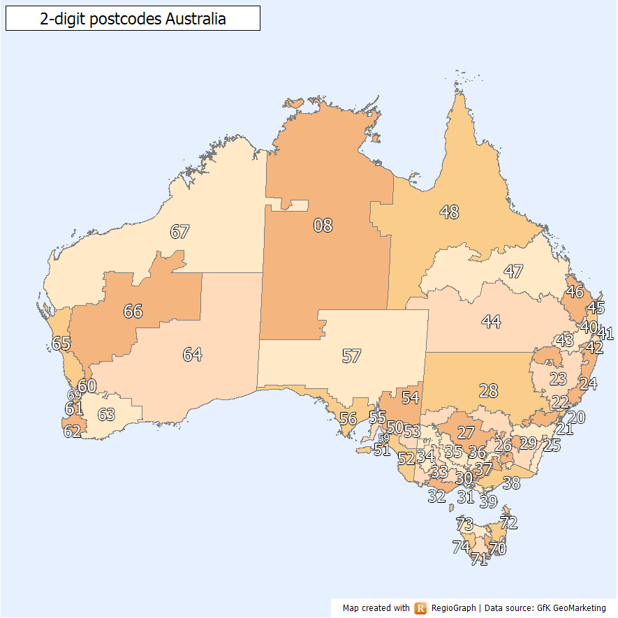
    There are a couple of things to keep in mind here. Firstly, the traditional Postcode systems that every other country has does not in fact allow for location of obscure addresses especially when they're in the middle of nowhere - a key concern of many posters here (and myself). The mental image of the ambulance driving up and down country lanes searching for the house with the guy having a heart attack springs to mind. I have a doc from work that lists the number of digits in the postcodes of every country that has one. It ranges from 4 digits in Australia (which gives 264 km2/code in Western Australia) to 4 digits in Liechtenstein (which gives 4 acres/code). Neither of these are granular enough to find a bungalow in a rural area.

    In response to this you have the satnavs and other adhoc solutions that are adjuncts to the postcode system.

    In Ireland, we're going to need to understand that a postcode system that combines the two (sorting mail easier and finding specific spots in the countryside) would undoubtedly result in a long code which wouldn't be memorisable and wouldn't catch on. There's no way to resolve this: if the code is short, it's easy to remember and catches on quick, but doesn't give detailed location info for rural areas; and if it's long, it has detailed info but is too long to memorize and many people won't play ball. If any kind of significant minority doesn't participate, it makes it harder for everyone else.


  • Registered Users Posts: 9,787 ✭✭✭antoinolachtnai


    No, you can resolve this.

    A 5-digit code can bring you down to around 60 houses (the CSO small areas).

    This is easily memorable, like the German or American code.

    An optional further digit gives a roadway within the postcode area.

    An optional further two digits gives the number of the house, or in rural areas, the number of tens of meters along the road that the house entrance is located. So:

    12345-678

    12345 is for the general area, dividing the company into around 20,000 areas.

    The 6 is for the road.

    78 specifies exactly where on the road the house or entrance is.

    You might not bother surveying out beyond the first five digits for city addresses where there is already a street name and number.

    You can go as far as people want - i.e., if people only want to use the general code, they can. They can also specify the street, if they wish, or they can go down to a very fine degree of 'granularity'.


  • Registered Users Posts: 2,278 ✭✭✭mackerski


    spacetweek wrote: »
    In Ireland, we're going to need to understand that a postcode system that combines the two (sorting mail easier and finding specific spots in the countryside) would undoubtedly result in a long code which wouldn't be memorisable and wouldn't catch on. There's no way to resolve this: if the code is short, it's easy to remember and catches on quick, but doesn't give detailed location info for rural areas; and if it's long, it has detailed info but is too long to memorize and many people won't play ball. If any kind of significant minority doesn't participate, it makes it harder for everyone else.

    There is a way to resolve it, but one that can cause implementation problems. The solution is to have house numbers everywhere and (optionally) road names. Basically, you keep the postcode manageably short, but require an additional address portion to be known. Even with a very fine-grained postcode like the UK one or that proposed here, you still need something more than the postcode for a full address match. Without house numbers, that something would in Ireland often need to be "The Murphy household, that's young Murphy, not his parents who live 1km further along".

    Having numbers and road names makes for simpler addresses, but can lead to agro since road names are often "imposed" in ways that make locals resistant to them. This seems to have happened in NI when postcodes were introduced, and road names with them.

    But you can have property numbering without road names. In small villages in Austria, for instance, you can have 3-digit house numbers assigned to every property. Or sometimes the village is divided into named areas each of which has a separate set of (usually smaller) house numbers.

    Here you could often get away with numbering within a townland. Doing so, you could achieve an accurate property match using an ABC123 postcode and a house number or house number/road name pair. With larger postcode areas (as used in most of Europe) you should still be able to assure address uniqueness as long as postcode, road name OR townland and house number are supplied. Though the latter scheme might require a purge on duplicate road names that might exist within the larger postcode area.


  • Moderators, Science, Health & Environment Moderators Posts: 5,034 Mod ✭✭✭✭spacetweek


    Just out of interest, here's a list of the countries that still don't have postcodes. I've omitted Africa because hardly any of them have them, and small states and Pacific/Caribbean islands. Some notes at the end.

    Albania **
    Andorra **
    Bahrain, Belize, Bhutan, Bolivia, Cambodia
    Chile #
    Colombia, Ecuador, El Salvador
    Gibraltar #
    Guatemala, Honduras
    Hong Kong #
    Iran #
    Ireland **
    Jamaica %
    Jordan, Kuwait, Laos, Lebanon
    Macau #
    Myanmar, Nepal, Nicaragua
    Nigeria #
    North Korea, Oman, Panama, Papua New Guinea, Paraguay, Peru
    Qatar, Saudi Arabia, Sri Lanka, Suriname, Syria
    United Arab Emirates, Vietnam, Yemen

    Notes:
    ** European countries: Andorra, Albania, Ireland. They're the only 3! Even Liechtenstein, Monaco, and San Marino have them!

    % Jamaica: This country introduced postcodes recently, but abolished them shortly afterwards due to the generally crappy way they were implemented.

    # These countries are interesting in some way:
    Chile: Surprised a country with their level of development doesn't have them yet. Argentina and Uruguay do.
    Gibraltar: Surprised this isn't integrated with Spain's system.
    Hong Kong/Macau: Same, with China.
    Iran and Nigeria: I'm amazed these two countries, with a combined 220 million inhabitants and large territories, don't have postcodes.


  • Registered Users Posts: 9,787 ✭✭✭antoinolachtnai


    The other thing to consider with all these countries is how structured the addresses are. The problem in Ireland isn't just the lack of a postcode, it's actually the whole address that is a problem. If we had a very clear addressing scheme, we potentially wouldn't have any need for a postcode. Hong Kong, for example, has a fairly standard structure for an address. Our address structure, by contrast, is very 'stringy'.


  • Closed Accounts Posts: 13,993 ✭✭✭✭recedite


    Don't forget that people will want something short to type into a satnav or mobile phone, preferably 8 or less digits. Anything that requires a written address component is starting to fall outside this.
    Also, I might want to arrange to meet a group of people at a forest car park, a marina or a beach. Why be restricted to houses?


  • Registered Users Posts: 9,787 ✭✭✭antoinolachtnai


    well, that's another problem really. Not saying it isn't an important one but the number one problem is providing services to human settlements. Certainly, it makes sense to allocate codes to developments like a car park or a marina.

    A beach? I guess the question is whether it is connected to the road network. If it is, then it would make sense to allocate a code to the entrance or car park. If it's remote from road networks, then is it really a place where services are going to be delivered? Is anyone really going to meet a group of people in such a place?

    The code isn't necessarily just about location in the GIS sense. It's also about the means of access. You might be a few hundred yards from a location, but it doesn't mean that you have any way to reach it.


  • Advertisement
  • Registered Users Posts: 2,278 ✭✭✭mackerski


    recedite wrote: »
    Also, I might want to arrange to meet a group of people at a forest car park, a marina or a beach. Why be restricted to houses?

    While it may turn out to be useful to have such places accessible by code, my feeling is that punching in a code won't be the enduring way to get there. Rather one of the following:

    * You do a POI search for Beach, Forest Park, whatever. Your device will enter a predictive mode, initially closest first. You punch in letters from the name of the destination until the one you need floats to the top of the list.

    * You have promotional material from the destination. If printed, this could contain a QR code containing raw lat and long, with GPS devices having scanners built in. Likewise, expect to see protocols for direct transfer of POI data from web pages to your satnav. All the more so as personal navigation devices begin to converge with smartphones.

    Direct entry of a code, which probably will happen to some extent, will ideally be of a very short code, one that isn't computed from co-ordinates (because the code would be too long) but allocated by a service similar to tinyurl. This is hard today, when most personal navigation devices are not connected to the Internet, but this limitation will not remain.


  • Closed Accounts Posts: 13,993 ✭✭✭✭recedite


    The particular forest or beach I am going to will have several entrances with separate parking areas. To avoid confusion, I want to meet at one of these. No listings in the form of satnav POI, or promotional literature codes will be available for these small parking areas. Raw lat and long data is too long and complicated; I want to e-mail a link showing a map of the location to the other people in advance. A location code of 8 or less digits, as per Go Code or Loc8 is very suitable.
    If I want a courier to deliver a parcel to me the next day, the same system is also very suitable for that.


  • Registered Users Posts: 2,278 ✭✭✭mackerski


    recedite wrote: »
    The particular forest or beach I am going to will have several entrances with separate parking areas. To avoid confusion, I want to meet at one of these. No listings in the form of satnav POI, or promotional literature codes will be available for these small parking areas. Raw lat and long data is too long and complicated; I want to e-mail a link showing a map of the location to the other people in advance. A location code of 8 or less digits, as per Go Code or Loc8 is very suitable.
    If I want a courier to deliver a parcel to me the next day, the same system is also very suitable for that.

    Sounds a bit like a National Grid reference. Not that those are well-supported by GPS devices, but at least they are established and transparent.


  • Registered Users Posts: 2,040 ✭✭✭yuloni


    This post has been deleted.


  • Closed Accounts Posts: 149 ✭✭jetpack101


    I can't see how the Loc8 could would be a problem for the post office.
    You still have your full address on the front of the envelope. You just added a couple of numbers at the end.

    I have tried to look at this from the post office point of view and I can't see how it would not work for them. As far as I'm aware the post office has a machine that reads addresses passed over a camera. Would it not make it easer if the machine did not have to read the full address just the first few digits of the Loc8 code.

    So it knows that NM will take them to North Dublin for example. This is much easer then trying to read a full address.

    I do think that the post office should have full access to incorporate loc8 into there systems but not edit or change its function in any way.


    I have said this before and I will say it again.. :D
    PLEASE bring out an app for android phones. There are lots of mobile phone companies using the android platform and only one using the Apple iPhone platform. The sooner you do this the sooner people can really start using it to there advantage. The quicker people see how easy it is to use the more people will want it.


  • Closed Accounts Posts: 443 ✭✭garydubh


    mackerski wrote: »
    While it may turn out to be useful to have such places accessible by code, my feeling is that punching in a code won't be the enduring way to get there. Rather one of the following:

    * You do a POI search for Beach, Forest Park, whatever. Your device will enter a predictive mode, initially closest first. You punch in letters from the name of the destination until the one you need floats to the top of the list.

    * You have promotional material from the destination. If printed, this could contain a QR code containing raw lat and long, with GPS devices having scanners built in. Likewise, expect to see protocols for direct transfer of POI data from web pages to your satnav. All the more so as personal navigation devices begin to converge with smartphones.

    Direct entry of a code, which probably will happen to some extent, will ideally be of a very short code, one that isn't computed from co-ordinates (because the code would be too long) but allocated by a service similar to tinyurl. This is hard today, when most personal navigation devices are not connected to the Internet, but this limitation will not remain.

    here's a tiny url: W8L-82-4YK - add this tiny url or any one like it to thus URL: www.loc8code.com and the result is:
    www.loc8code.com/W8L-82-4YK
    and you're there... guess this is what you mean!


  • Registered Users Posts: 412 ✭✭IrlJidel


    garydubh wrote: »
    here's a tiny url: W8L-82-4YK - add this tiny url or any one like it to thus URL: www.loc8code.com and the result is:
    www.loc8code.com/W8L-82-4YK
    and you're there... guess this is what you mean!

    Openstreetmap already has a lat/lot shortening code.

    Your approx location equivalent would be eslG2BKPf

    http://osm.org/go/eslG2BKPf--

    Code to generate the code is 27 lines of javascript.

    Now, I notice OSM map of Crosshaven is missing GPS House and the name of Church Bay Road.

    Can you use a published LOC8 code to update address data elsewhere, for example OSM?


  • Closed Accounts Posts: 443 ✭✭garydubh


    IrlJidel wrote: »
    Openstreetmap already has a lat/lot shortening code.

    Your approx location equivalent would be eslG2BKPf

    http://osm.org/go/eslG2BKPf--


    Surely you are not serious?

    You mean you would have people living at:
    http://osm.org/go/eslesbian

    or even

    http://osm.org/go/esfu*ker

    and look http://osm.org/go/esFU*KER is a different f'ing place? (different location when capitals are used)

    Perhaps this would be the place for all the electricity bills:
    http://osm.org/go/esbbills - not many 'ohms there though!

    .............and I like where you've put our Taoiseach:
    http://osm.org/go/esbcowen

    and I am amazed at the fact that Esbjerg in Denmark has been moved by OSM to Limerick: http://osm.org/go/esbjerg - oh the power of mapping!


    ..... honestly IrlJidel I really think there is more to it than that if you want the public to use it - perhaps a few more lines of code would sort it!


  • Posts: 31,118 ✭✭✭✭ [Deleted User]


    OK this thread has gone a long way in recent months, so I'm going to come up with a simple suggestion.

    Link emails to geographic locations using any of the systems mentioned above.

    A simple application where a user enters the email (with prior authorisation from the addressee) and a map appears giving the precise location.


  • Advertisement
  • Registered Users Posts: 2,278 ✭✭✭mackerski


    OK this thread has gone a long way in recent months, so I'm going to come up with a simple suggestion.

    Link emails to geographic locations using any of the systems mentioned above.

    A simple application where a user enters the email (with prior authorisation from the addressee) and a map appears giving the precise location.

    It's a nice idea, along the lines of what Web Finger is trying to do - basically hanging a load of information that you choose to make available about yourself (= a profile) off your email address and allowing others to look it up. The beauty of using the email address is that people will already know it and it's (hopefully) pretty memorable.

    A location element is tricky within web finger, though, since it is intended to provide not-so-secret information, like where your Flickr home page is. People you don't want to see your private pics on Flickr won't gain access to them even if they can use web finger to find out your Flickr username. But few people would want to publish location information quite that openly. And if they did, what location would that be? Where they are now? Where they live or work?

    You could do it, though, and it's a nice example of the kind of code-free information transfer that I expect to become the norm. A location keyed against email address could be expressed in any grid or code system, but lat and long would seem most reasonable.

    I'll give some thought to how web finger or something like it could be used to solve this problem.


This discussion has been closed.
Advertisement