Advertisement
If you have a new account but are having problems posting or verifying your account, please email us on hello@boards.ie for help. Thanks :)
Hello all! Please ensure that you are posting a new thread or question in the appropriate forum. The Feedback forum is overwhelmed with questions that are having to be moved elsewhere. If you need help to verify your account contact hello@boards.ie

National Postcodes to be introduced

Options
1268269271273274295

Comments

  • Registered Users Posts: 7,252 ✭✭✭plodder


    oscarBravo wrote: »
    I don't recall that objection. I do recall pointing out that small area boundaries get redefined, so including them in the code itself would require changing postcodes, whereas having them referenced in a database only requires updating database records.
    We've been through this before. Boundaries would get redefined but in the vast majority of cases, no existing codes would have to change.


  • Registered Users Posts: 7,252 ✭✭✭plodder


    [sarcasm]Really? I never knew that[/sarcasm]

    Which kind of disproves arguments made previously in this thread (by other posters IIRC) that UK postcodes are linked to meaningful geographical locations.

    I don't think a postcode system that uses an abbreviation of one city (Belfast) for an entire region of the UK quite meets that standard, do you?

    I'm pretty sure that people in Co. Fermanagh, for example, don't find any particularly meaningful link between the letters BT and the county of Fermanagh. Unless they're unique among the inhabitants of the island of Ireland in not having any sentimental attachment to their county. Same goes for people from any of the other counties in the north.
    Have to call you out on that as well. The fact that NI has the code BT rather than say NI is not really all that important. What matters is that the code (whatever it is) for NI refers to Northern Ireland only and not NI plus a bit of Scotland and Wales and minus a bit of County Antrim or Armagh. That matters from a delivery point of view, because BT postcodes are all located a boat journey away from all the other ones.


  • Technology & Internet Moderators Posts: 28,805 Mod ✭✭✭✭oscarBravo


    plodder wrote: »
    Boundaries would get redefined but in the vast majority of cases, no existing codes would have to change.
    And in a significant minority of cases, they would.

    This is my point: you're designing in the inevitability of either considerable disruption to a number of addressees (whatever about householders, it's a seriously big deal for a business to have its address change), or else pressure on CSO not to update small area boundaries in a way that makes sense for them.

    This has to be weighed up against the benefits of having the small area encoded in the postcode. Now, you might weigh those factors differently, but that doesn't mean that the design decision was wrong.


  • Registered Users Posts: 7,252 ✭✭✭plodder


    oscarBravo wrote: »
    And in a significant minority of cases, they would.

    This is my point: you're designing in the inevitability of either considerable disruption to a number of addressees (whatever about householders, it's a seriously big deal for a business to have its address change), or else pressure on CSO not to update small area boundaries in a way that makes sense for them.

    This has to be weighed up against the benefits of having the small area encoded in the postcode. Now, you might weigh those factors differently, but that doesn't mean that the design decision was wrong.
    The design decision didn't weigh up the pros and cons of the issue as we are discussing it now. That it is the problem. Some people were saying that small areas were no good, and now we see that Autoaddress think they are great.

    Some change occurs in hierarchical systems like the UK postcode, but it is minimised and not anything like the wholesale change that some people here are predicting. The whole idea of atomic small areas is that they don't change much except when being sub-divided, which doesn't affect existing codes.

    Also, the fact is that Eircodes will change whenever An Post changes its routing key areas. That might not happen for a few years, but nobody can say now, that it won;t happen.


  • Registered Users Posts: 9,455 ✭✭✭TheChizler


    Nobody is saying small areas are no good. This is a massive straw man.


  • Advertisement
  • Technology & Internet Moderators Posts: 28,805 Mod ✭✭✭✭oscarBravo


    plodder wrote: »
    The design decision didn't weigh up the pros and cons of the issue as we are discussing it now.
    How do you know?
    Some people were saying that small areas were no good, and now we see that Autoaddress think they are great.
    Who said they were no good? They're included in the ECAD, so they form part of our postcode system for anyone who needs them.


  • Registered Users Posts: 1,341 ✭✭✭SPDUB


    But Portmarnock was not in a Dublin postcode but it is now. I would imagine it is not the only place to move about.

    Yes it was .

    The only difference was that you didn't know about it .


  • Registered Users Posts: 2,091 ✭✭✭marmurr1916


    plodder wrote: »
    Have to call you out on that as well. The fact that NI has the code BT rather than say NI is not really all that important. What matters is that the code (whatever it is) for NI refers to Northern Ireland only and not NI plus a bit of Scotland and Wales and minus a bit of County Antrim or Armagh. That matters from a delivery point of view, because BT postcodes are all located a boat journey away from all the other ones.

    Call me out all you like - you're calling me out on a point I never made. The fact that BT is used for all of Northern Ireland proves that there isn't necessarily any link between the letter(s) used in the first part of a postcode and a local area (the point I actually made), unless you think that all of NI is a local area.

    If all of NI can be covered by one postcode area, why do people object to one routing key letter being used to cover Clare, Limerick, Kerry and bits of other counties? Why one standard for a huge postcode area like NI but a different standard for a huge routing key area like west Munster?

    If Wales (population ca. 3.2 million) can be sub-divided into about a dozen postcode areas, then why couldn't NI (population ca. 1.8 million) have been sub-divided into several postcode areas? BT could have been used for Belfast, maybe AM for Antrim, DN for Down etc. Avoid any (London)Derry aggro by using SB (Strabane) for the city and west of the county and CN (Coleraine) for the east. After all, there was briefly a county of Coleraine laid out in the 16th/17th centuries and Strabane is now part of a single local authority which includes bits of Co. Derry and the city: http://www.derrycityandstrabanedistrict.com

    If the effort was made to sub-divide Wales into smaller postcode areas in order to make some attempt (however poor it turned out to be in reality) to provide postcode areas with local meaning why not make the same effort for NI?

    Clearly there is no rule that the individual component parts of the UK must be covered by one postcode area using letters based on their capitals. If there was, all of Scotland would be covered by the EH (Edinburgh) postcode area and all of Wales would be covered by the CF (Cardiff) postcode area.

    Speaking of "a boat journey away" most of the KW postcode area is on the Scottish mainland but several of its postcode districts cover the Orkney islands.

    Clearly there is no rule that a postcode area musn't be split between bits of the UK that are connected by land to the rest of the UK and bits of the UK that require a boat or plane to access from the rest of the UK.

    The idea that all of NI is covered by one postcode area because it's a "boat journey away" is undermined by the KW postcode area which is split between districts that are a boat journey away (sometimes several boat journeys away, especially for the smaller islands) from the Scottish mainland and districts that aren't a boat journey away but can be accessed without the need to take a ferry from any part of the Scottish mainland.


  • Registered Users Posts: 2,091 ✭✭✭marmurr1916


    plodder wrote: »
    Some change occurs in hierarchical systems like the UK postcode, but it is minimised and not anything like the wholesale change that some people here are predicting.

    Up to 1990, the AB postcode area included five districts (AB1, AB2, AB3, AB4, AB5) that covered Aberdeen city and surrounding areas.

    This was completely changed from 1990 and sub-divided (and extended) into many more districts.

    All of the Aberdeen postcodes were changed from, for example, AB1 1AA to either AB10, AB11 (or AB1x) or AB2 2ZZ to AB25 (or AB2x) depending on their exact location.

    In addition several postcode districts in adjoining postcode areas were incorporated into new postcode districts within the expanded AB postcode area.

    For example, several IV postcode districts were abolished and the addresses in those districts became part of the AB38 postcode district.

    The cost and disruption to businesses was huge especially when you consider that most businesses still had printed letterheads and other printed stationary (which was generally produced by professional printers rather than using office equipment) and that many business databases were still largely in printed form (e.g. phone directories, Kompass business directories) back then.

    Apart from that wholesale postcode reorganisation of an entire city and surrounding counties, there have also been wholesale changes made to postcodes on the Wirral peninsula (a very heavily populated area across the River Mersey from Liverpool) which went from having L (for Liverpool) postcodes to CH (for Chester) postcodes some years ago.
    plodder wrote: »
    Also, the fact is that Eircodes will change whenever An Post changes its routing key areas. That might not happen for a few years, but nobody can say now, that it won;t happen.

    [sarcasm]TBTG that would never happen under a hierarchical postcode system, like that used in the UK:[/sarcasm]
    The Outer Hebrides were completely re-coded in 1995, creating the new postcode area HS. The islands had previously had a PA postcode.

    http://www.geograph.org.uk/article/Postal-address-history-and-photo-album/2

    Here are some more examples of wholesale, definitely not minimised, changes that have occurred in the hierarchical UK postcode system.
    ...postcodes have changed in all sorts of ways, major and minor, since the first national scheme was completed. Here are a few of the more major examples:

    The Outer Hebrides were completely re-coded in 1995, creating the new postcode area HS. The islands had previously had a PA postcode.

    The AB area was given an increase in capacity by re-coding the original codes AB1 to AB5. These were given two digit numbers, AB1 becoming AB1x and AB2 becoming AB2x, etc. The SO and CF areas have been similarly altered, too, as have parts of several others.

    The Wirral peninsula has been moved from L to CH, without changing any further digits.

    http://www.geograph.org.uk/article/Postal-address-history-and-photo-album/2

    Apart from changes to postcodes the entire Royal Mail PAF database of all UK postal addresses was changed from 1996 to 2000 when postal counties (the boundaries of which didn't necessarily correspond exactly to the boundaries of either pre-1974 or post-1974 local authority boundaries) were abolished by Royal Mail.
    The postal counties of the United Kingdom, now known officially as the former postal counties, were postal subdivisions in routine use by Royal Mail until 1996.[1] The raison d'être of the postal county – as opposed to any other kind of county – was to aid the sorting of mail by enabling differentiation between like-sounding post towns. Since 1996 this has been done by using the outward code (first half) of the postcode instead. For operational reasons the former postal counties, although broadly based on the counties of the United Kingdom, did not match up to their boundaries, in some cases with significant differences. The boundaries changed over time as post towns were created or amended.

    According to the Royal Mail, the former postal county data no longer forms part of postal addresses. It was removed from the Postcode Address File database in 2000 and does not form part of its code of practice for changing addresses.[2] Despite this, county data is routinely sold to companies, ostensibly in order for them to cleanse their own address data. As the former postal county data was the last to be in routine use, some organisations have continued to use this obsolete data as part of postal addresses. In 2009 the Royal Mail code of practice consultation included discussion of the possibility of replacing the currently supplied 'alias data' with an up-to-date county information data field.[3] In 2010 the regulator advised Royal Mail to cease supply of county data altogether,[4] and a timetable has been put in place for this to occur between 2013 and 2016.[5]

    https://en.m.wikipedia.org/wiki/Postal_counties_of_the_United_Kingdom

    So there have been major changes to entire Scottish postcode areas (including the city of Aberdeen and surrounding areas, and the creation of a completely new postcode area - HS), major changes to entire English and Welsh postcode areas (including the city of Southampton and surrounding areas and the city of Cardiff and surrounding areas) and changes to large parts of other English postcode areas, while the entire postal address database was changed in 2000 to remove former postal counties (which had been changed after 1974, with many exceptions, including all of Scotland!) from postal addresses.

    Wholesale enough for ya? :D


  • Registered Users Posts: 2,091 ✭✭✭marmurr1916


    OMG! There are towns in the UK that have been 'moved' to different counties by Royal Mail.

    Someone should contact the media and start a thread on these Postcode Anomalies!
    Because the post towns had developed according to the efficiencies of mail delivery, there are many, many instances where a locality comes under a post town in a neighbouring county. If a town is close to the boundary, it will probably be the nearest town for parts of the next county and it would not make sense to deliver mail from within the 'correct' county when there is a sorting office so close by over the border. Therefore, the vast majority of county boundaries feature some kind of discrepancy

    http://www.geograph.org.uk/article/Postal-address-history-and-photo-album

    And they put a major airport in the wrong county. [sarcasm]Tsk - only in Ireland, eh?[/sarcasm]
    There are a few post towns which have a county assigned to them even though they are not in that county:
    GATWICK, Surrey – Gatwick Airport is actually in West Sussex; the post town however was created from HORLEY, Surrey

    http://www.geograph.org.uk/article/Postal-address-history-and-photo-album/


  • Advertisement
  • Banned (with Prison Access) Posts: 158 ✭✭GJG


    plodder wrote: »
    Also, the fact is that Eircodes will change whenever An Post changes its routing key areas. That might not happen for a few years, but nobody can say now, that it won;t happen.

    Can you give your source for that?

    Your phrasing holds that it is a certainty that some people will have their Eircode changed every time that An Post changes its routing key areas. It's that that I'm looking for a source for. Who said that, and how do we know that they know for sure?

    I ask that because the people most hostile to Eircodes have a record of making extravagant negative claims about Eircode, without citing any sources, and being something between dismissive and abusive of people who questioned them. The claims included that the Rock of Cashel would get no Eircode, that UCD's Belfield would get only one Eircode, that the Eircode database would be over 2GB and too big to fit on any smartphone or satnav, and that the takeup of Eircodes would be negligible compared to Loc8. Each of these have turned out to be entirely false.

    So that we can verify that what you say doesn't follow the same pattern, can you provide anything to indicate where you are getting your information?


  • Registered Users Posts: 184 ✭✭Aimead


    oscarBravo wrote: »
    The clear implication of your post to which I was replying is that Eircodes don't provide locational functionality.
    Ignoring the same context, directly after it was point out for you again, is taking the piss to be honest.

    Let me ELY5 for you: Geocodes are codes entirely about location, no database or licensing required – even visually if the design is sensible. The actual code of Eircode is very low-resolution locational code, which curtails its functionality, and for non-indexed locations there is no functionality whatsoever.

    How many times have I repeated these themes? How many times will you continued to ignore them for the cheap shot?
    Cheap strawmen? Let's see... Shannon Airport isn't in Limerick.
    I never said it was. You ignored the context of the discussion, and I had even made a post that explicitly provided that context to you. But no, another strawman.

    Here is the context. The other posters was raising the point about people being confused. My reference to Shannon Airport was illustrating that, with current Eircode, the difference between what people think their address and their postal address is causing confusion. It was to highlight to the other poster that, even if their point about confusions had merit, how Eircode turned out had led to confusion anyway – that no matter what system had been chosen there was always going to be some confusion and a period needed to develop familiarity.

    But no, you just waded into a discussion I was having with another poster and tried to score a cheap shot.
    ….stop getting shirty with people who point out the things you're saying that aren't true.
    I do reserve the right to get shirty when examples of cheap shots like the above occur. Seriously, what is the point you doing those?
    ukoda wrote: »
    Hmmm, well you seem to be of the "my way or the highway" mind set.... reminiscent of dictatorships!
    To be fair, I haven’t insulted or attempted to belittle anyone – so surely I’m allowed enough slack to crack at least one little joke.

    But let me make a more serious point. You have said, repeatedly, that you don’t care about certain functionality because it doesn’t affect you. Can you see how combining that approach with ‘it’s all opinion man’ is a little questionable?
    You're a member of the Flat Earth Society? You're from Lancaster?
    My dad was a member and it sort of rubbed off. You occasionally get meetings in the UK, but they little more than forum organised meetups. US has still an active society, but in the UK it’s pretty much dead.
    Which kind of disproves arguments made previously in this thread (by other posters IIRC) that UK postcodes are linked to meaningful geographical locations.
    Can’t speak for other posters, but that’s not the position I’ve been arguing. My contention is that UK postcodes can, on visual inspection, give useful information of where locations are with reference to each other. My source: years of using them to just that.

    As I said previously even if you grant that UK postcodes are poor, doesn’t the fact that they outperform Eircode on this aspect not at least cause a double-take?
    If all of NI can be covered by one postcode area, why do people object to one routing key letter being used to cover Clare, Limerick, Kerry and bits of other counties? Why one standard for a huge postcode area like NI but a different standard for a huge routing key area like west Munster?
    I don’t understand the questions and I think you’ve missed the thrust of the objections to Eircode here. For me, the UK postcode visually contains useable information in all of its digits, in contrast to Eircode where the last four digits are pseudo-random and thus don’t visually give information.

    The bit you are missing is that, in a sense, NI is already divided up into smaller areas. There are 82 large areas (BT1, BT2, etc.). For each of those the further digits of the postcode the area is subdivided into smaller areas. With Eircode only the first three digits, the routing key, does any subdividing.

    Does that make sense?
    All of the Aberdeen postcodes were changed from, for example, AB1 1AA to either AB10, AB11 (or AB1x) or AB2 2ZZ to AB25 (or AB2x) depending on their exact location.
    Imagine, for a moment, the postcode was changed to a proper geocode – you’d never have to make any changes. Well, if you factor in erosion, continental drift, etc., you might have to make a small tweak in a hundred thousand years, but I think that’s acceptable.
    GJG wrote: »
    I ask that because the people most hostile to Eircodes have a record of making extravagant negative claims about Eircode, without citing any sources, and being something between dismissive and abusive of people who questioned them. The claims included that the Rock of Cashel would get no Eircode, that UCD's Belfield would get only one Eircode, that the Eircode database would be over 2GB and too big to fit on any smartphone or satnav, and that the takeup of Eircodes would be negligible compared to Loc8. Each of these have turned out to be entirely false.
    I genuinely don’t get the point of this. Why are you ignoring what the people in this thread have actually posted, and instead chosen to complain about a series of claims that nobody in the thread has made since you last complained about them???


  • Technology & Internet Moderators Posts: 28,805 Mod ✭✭✭✭oscarBravo


    Aimead wrote: »
    Ignoring the same context, directly after it was point out for you again, is taking the piss to be honest.

    Let me ELY5 for you: Geocodes are codes entirely about location, no database or licensing required – even visually if the design is sensible. The actual code of Eircode is very low-resolution locational code, which curtails its functionality, and for non-indexed locations there is no functionality whatsoever.

    How many times have I repeated these themes? How many times will you continued to ignore them for the cheap shot?
    I'm not ignoring them. You seem to think you can say things that are not true, and get away with them because, earlier in the thread you've made it clear that you know they're not true, and therefore we should all pretend along with you that you're not saying things that aren't true.

    Yes, you've made it clear that you believe postcodes should be algorithmically calculated from a latitude and longitude (and, apparently, altitude, but we'll let that slide). The fact that you've made that clear doesn't make it any less untrue when you argue that Eircodes don't have a locational functionality.

    You claim that Eircode is a "very low resolution locational code" - this is yet another blatant distortion. Sure, if you don't have a mechanism for translating an Eircode to a latitude and longitude, it's low-resolution - but if you do, it's utterly precise.

    I get that it would be easier for you to post untruths if I played along just because I know that you know what you're posting isn't true, but I see no reason to be complicit in that.
    I never said it was. You ignored the context of the discussion, and I had even made a post that explicitly provided that context to you. But no, another strawman.
    If you have a problem with me calling you out when you post things that aren't true, stop posting things that aren't true and then arm-waving about context when you're called on it.
    Here is the context. The other posters was raising the point about people being confused. My reference to Shannon Airport was illustrating that, with current Eircode, the difference between what people think their address and their postal address is causing confusion.
    And here's what you actually said:
    I don’t see how the above is any more confusing than current Eircode with Shannon Airport being in Limerick…
    Don’t get me started with people who have suddenly found they live in a different [county]...
    These are things you have said that are not true. Yes, I know from the context that you mean something other than what you've posted, but that doesn't magically make the things you've posted true; it means that you're posting falsehoods and then getting cross when I refuse to let this dishonest debating tactic slide.
    I do reserve the right to get shirty when examples of cheap shots like the above occur. Seriously, what is the point you doing those?
    Saying that Shannon Airport is in Limerick isn't a cheap shot? Saying that people have suddenly found they live in a different county isn't a cheap shot? Saying that a postcode that precisely identifies specific buildings is "very low resolution" isn't a cheap shot?


  • Registered Users Posts: 184 ✭✭Aimead


    oscarBravo wrote: »
    (and, apparently, altitude, but we'll let that slide).
    That’s simply a misconception on your part. If you have multiple valid addresses at the same locations (eg: in an apartment building) then you must have a way to differentiate them. Adding that to a geocode makes it 3-dimensional (hence the use of the phrases ‘height’ or ‘z-axis’), and this is not in any way related to physical altitude. You have simply misunderstood the language of codes and vectorspaces on this point.
    ….when you argue that Eircodes don't have a locational functionality.
    The actual code of Eircode, outside the routing key, doesn’t have locational functionality. The whole complaint against Eircode is that it chose to use pseudorandom digits rather than digits that gave location functionality. Are you seriously trying to argue this isn’t the case….??
    You claim that Eircode is a "very low resolution locational code" - this is yet another blatant distortion. Sure, if you don't have a mechanism for translating an Eircode to a latitude and longitude, it's low-resolution - but if you do, it's utterly precise.
    But the whole argument is that Eircode, the actual code itself, doesn’t have that mechanism – so how can saying Eircode is a low resolution code be a blatant distortion????? You just admitted that without a translation mechanism, which doesn’t exist in the code itself outside the routing key due to the pseudorandom digits, it is low resolution!!!!

    Are you taking the piss?
    I get that it would be easier for you to post untruths…
    If you continue to ignore the context behind those posts then I’m sure you’ll keep seeing half-truths.
    And here's what you actually said:
    Yes, let’s look at those but let’s also include the context.
    The first quote, “I don’t see how the above is any more confusing than current Eircode with Shannon Airport being in Limerick… ”, was referencing the confusion people were having. Here is the complete quote before you quote-mined it (I’ve highlighted the important bit you deliberately left out): “I don’t see how the above is any more confusing than current Eircode with Shannon Airport being in Limerick – it just needs to be explained to people and time allowed for getting familiar with it. The difference is that, in my proposed scenario, the code offers a wealth of functionality that comes with being a geocode.

    The second quote: “Don’t get me started with people who have suddenly found they live in a different [county]... ”. Compare this the full quote before quote-mining (again, relevant portion highlighted): “As it stands right now I have had to explain to people, multiple times, to that it isn’t possible for their outhouse or farm or building site to have an Eircode – would it be a fair argument to say this demonstrates that current Eircode isn’t simple? Don’t get me started with people who have suddenly found they live in a different country, they just aren’t able to grasp that one.

    The ironic thing about the second quote is that I was, in a small way, mocking people for having that misconception.

    There comes a point where the assumption of good faith becomes untenable. The above two quote-mines are sheer dirt on your part.
    Saying that a postcode that precisely identifies specific buildings is "very low resolution" isn't a cheap shot?
    The code itself does no such thing. Ffs with this same logic you could argue that telephone numbers precisely identifies specific buildings since you can also look them up in a database, but then a telephone number was never intended to be a national postcode.


  • Registered Users Posts: 2,091 ✭✭✭marmurr1916


    Aimead wrote: »
    Here is the context. The other posters was raising the point about people being confused. My reference to Shannon Airport was illustrating that, with current Eircode, the difference between what people think their address and their postal address is causing confusion.

    It's nothing to do with 'the current Eircode'. The postal address of Shannon Airport has been Limerick for many years. The only reason that this has become known to the general public recently is because people have been able to input part of the address to find its Eircode(s) and the Eircode finder website shows its correct postal address.

    The fact that the correct postal address for Shannon Airport includes Limerick has generated a bit of media attention and thus brought it to public attention.

    Had the internet been available to the general public for looking up addresses and postcodes in 1974, when Gatwick Airport was located geographically in West Sussex but was in the postal county of Surrey according to Royal Mail, I've no doubt that this 'relocation' of Gatwick Airport to the 'wrong county' would have become widely reported in the media.

    As far back as the 19th century, many addresses in Ireland and the UK have been formatted as follows:

    Street Name
    Village
    Via Postal Town
    Postal County

    Or perhaps more clearly:

    11 Main Street
    Mullaghmore
    via Bundoran
    Co. Donegal

    Even though Mullaghmore is geographically located within Co. Sligo.

    Why?
    Because the post towns had developed according to the efficiencies of mail delivery, there are many, many instances where a locality comes under a post town in a neighbouring county. If a town is close to the boundary, it will probably be the nearest town for parts of the next county and it would not make sense to deliver mail from within the 'correct' county when there is a sorting office so close by over the border. Therefore, the vast majority of county boundaries feature some kind of discrepancy

    http://www.geograph.org.uk/article/Postal-address-history-and-photo-album

    The fact that the address format of Street, Village, via Post Town, Postal County largely fell out of use is neither here nor there - it has been the correct postal address since the 19th century and neither the introduction of postcodes nor eircodes have changed that.
    Aimead wrote: »
    Can’t speak for other posters, but that’s not the position I’ve been arguing.

    I didn't say it was and I wasn't replying to you when I made that point.
    Aimead wrote: »
    My contention is that UK postcodes can, on visual inspection, give useful information of where locations are with reference to each other. My source: years of using them to just that.

    And therein lies the problem. You have years of using them.

    You've claimed that a visual inspection of UK postcodes gives useful information about where locations are with reference to each other. By 'where locations are with reference to each other' I presume you don't mean something as trivial as 'postcode location A is relatively close to postcode location B' but something more useful such as 'postcode location A is roughly north of postcode location B'.

    And presumably this ability to figure out where locations are relative to each other by visual inspection of postcodes applies even if I don't have years of using UK postcodes.

    Presumably all I need to know is how UK postcodes are formatted and I can use deductive reasoning and visual inspection to figure out the rest.

    That might hold water if every postcode area were subdivided into postal districts in the same manner and if every postal district were subdivided into sectors in the same manner.

    Imagine if every postcode area had its postal districts numbered using the same pattern.

    For example, the first postal district (always numbered 0) might always be in the top left 'corner' of the postcode area (for NI that would mean that BT0 would roughly be the western side of Derry city), for the parts of Co. Durham that use DH postcodes it would mean that DH0 would be in rural Co. Durham, to the west of Consett, with the following districts up to a maximum of 9 (e.g BT9, DH9 - if it existed) centred roughly along the same lateral axis, giving us XX0 to XX9 in a row.

    Below XX0 to XX9 you'd have XX10 to XX19 and so on until you reached XX99.

    Something like this:

    XX0 | XX1 | XX2 | XX3 | XX4 | XX5 | XX6 | XX7 | XX8 | XX9
    ____________________________________________________________

    XX10|XX11|XX12|XX13| XX14| XX15 |XX16|XX17|XX18 |XX19
    _____________________________________________________________

    XX20|XX21|XX22|XX23| XX24 | XX25 |XX26 |XX27|XX28|XX29

    and so on.

    We can then add some rules to this pattern.

    The top row of postal district numbers would be reserved for postal districts that had no other postal districts within the same postcode area above them, the second row of postal districts is reserved for postal districts with one other row of postal districts above them, the third row for postal districts with two other rows of postal districts above them and so on.

    Each row of postal districts doesn't have to use all available numbers, just as many numbers as there are postal districts in that row and postal district numbers for postal districts in the second and subsequent rows are always aligned with the postal district number in the row above. For example a postal district which is in the row below postal district XX9 is always numbered XX19, the one below XX19 is always numbered XX29 etc, even where this leads to gaps in the numbering sequence - if there's no postal district underneath (roughly to the south) a postal district then the number for the 'missing' postal district isn't assigned.

    The number for a postal district below where there is ambiguity about how many postal districts are roughly to its north in the row above (for example, Durham central postal district has Chester Le Street West and Chester Le Street East roughly to its north in the row above) should always be taken from the western postal district. So if Chester Le Street West is DH2, then Durham central would be DH22.

    But since all postcode areas are not configured in the same manner (a method that could still be used even if a postcode area were sub-divided into only 9 postal districts, like the DH postcode area) I can't figure out the relative position of DHx to DHz without prior knowledge of the DH postcode area or without looking up the DH postcode area on a map.

    If there was a consistent pattern for sub-dividing postcode areas into postal districts along the lines suggested above, I would be able to figure out by visual inspection that DH0 is the western most postal district in the DH postcode area and that DH5 is to the east of DH0, with DH1, DH2, DH3 and DH4 in between from west to east in that order, like so:

    West >>>>>>>>>>>>>>>>>>>>>>>>>>>>>>>>>East
    First (top) Row:
    DH0 | DH1 | DH2 | DH3 | DH4 | DH5 |
    _____________________________________________________

    Second Row:

    DH10 |---|DH12|

    _____________________________________________________

    Third Row:

    --- | --- | DH22 |


    And I wouldn't need a map or any prior knowledge of the DH postcode area to figure it out because every postcode area would have its postal districts numbered in the same pattern as set out in the top table (the 'XX' table) above.

    If that were true, then visual inspection alone would work.

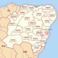
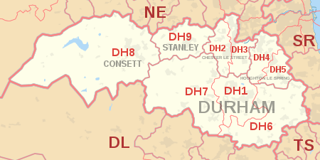
    But since the DH postcode area has its postal districts numbered in a different pattern to the pattern that the AB postcode area's postal districts are numbered (see maps below), how can I tell by visual inspection of the postcodes that DH is actually to the west of DH1?

    200px-AB_postcode_area_map.svg.png

    450px-DH_postcode_area_map.svg.png

    Let's assume that I didn't have any prior knowledge of the DH postcode area or any access to a map of the DH postcode area.

    Could I figure out the relative positions of DH6 and DH8 with respect to DH1 by using clues from the structure of the AB postcode area?

    Unfortunately not, because the AB postcode area doesn't contain postal districts numbered below 10 (i.e. it begins with AB10).

    So we can't figure out how one postcode area's postal district numbers are patterened from looking at another postcode area or from our knowledge of how UK postcodes are structured or from visual inspection of the postcodes, because each postcode area, whether its AB or DG or DH or HR (see maps below), can have its own pattern for numbering postal districts which doesn't necessarily reflect the pattern applied to the numbering of postal districts within other postcode areas.

    480px-AB_postcode_area_map.svg.png

    240px-DG_postcode_area_map.svg.png

    450px-DH_postcode_area_map.svg.png

    300px-HR_postcode_area_map.svg.png

    What about figuring out how Scotland is sub-divided into postal districts purely from visual cues, based on our knowledge of how Northern Ireland is sub-divided into postal districts? Without any prior knowledge of Scottish postcodes, without any map, we should be able to deduce the rough structure of Scottish postcodes from the postcodes in Northern Ireland.

    So we'd assume (being creatures of logic) that the lesser populated parts of the UK may be similar to each other in their postcode structures.

    Armed with this logical assumption, we could assume that since Northern Ireland has only one postcode area (BT) that Scotland too may have only one postcode area.

    We know that NI's postcode is derived from the name of its capital, Belfast.

    Knowing that Edinburgh is the capital of Scotland we assume that Scotland is divided into one postcode area, EH.

    And that Wales is divided into one postcode area, CF for Cardiff.

    But we're wrong. How do we know we're wrong? Either through prior knowledge or by checking a map...

    We can't use visual cues from the postcodes alone to figure out how Scotland or Wales are sub-divided, even if we already know how NI is sub-divided.

    So we can't rely on visual inspection to figure out whether NI's use of a single postcode area (BT) applies to other regions of the UK (e.g. Wales, Scotland) because the way that the BT postcode area is applied to all of NI is unique and isn't replicated for Scotland or Wales or for regions of England (e.g. NE is not used across all of the North-East of England).

    And we can't rely on visual inspection to figure out the relative positions of postal districts within different postcode areas. Because each postcode area has numbered its postal districts according to different patterns (e.g. AB is different from DG which is different from DH which is different from HR etc etc).

    And we can't rely on visual inspection to figure out how sectors within postal districts are located relative to each other because each postal district may have its sectors numbered in a different pattern to other postal districts (e.g. numbered sectors within AB11 may have a different pattern to sectors within DH1).
    Aimead wrote: »
    As I said previously even if you grant that UK postcodes are poor, doesn’t the fact that they outperform Eircode on this aspect not at least cause a double-take?

    In what sense do they outperform Eircode in this aspect? Can you figure out the relative location of DH1 with respect to DH8 and DH6 without having prior knowledge of how the DH postcode area is configured into its postal districts or without looking up the DH postcode area on a map?

    Can you figure out the relative location of DL13 4 to DL13 3 and DH8 0 without looking up the information on a map? How is one postcode system which requires either prior knowledge or checking of maps better than another system which requires either prior knowledge or checking of maps?
    Aimead wrote: »
    I don’t understand the questions

    Evidently.
    Aimead wrote: »
    and I think you’ve missed the thrust of the objections to Eircode here. For me, the UK postcode visually contains useable information in all of its digits

    For you. But you have 'years of using them' including no doubt years of checking maps. What's usable about the sector code in the postcode B6 5NE if you can't be sure where sector 5 is in relation to sectors 6 and 7 (e.g. B6 6AA, B6 7ZB), or where B6 is in relation to B7 or B8 without years of experience in using UK postcodes or without looking them up on a map?

    Look at this map of central AB postal districts which includes some sectors within those districts:

    ab-customised-postcode-map.png

    If I look at AB15 I can see that AB15 6 is to the north of AB15 7. And if I look at AB10 I can see that AB10 6 is north of AB10 7. Logically then, AB15 4 should be north of AB15 6 (I'm assuming that the rule is that the lower the sector number, the further north it is within the postal district).

    But AB15 4 is actually south of AB15 6 and AB15 8 is north of AB15 4 and AB15 7.

    So what is the rule for the numbering of postal sectors within the AB15 postal district?

    Is there a rule that's consistent even within individual postal districts (e.g. AB15), let alone across different postal districts within the same postcode area (e.g. AB10 and AB15), let alone different postal districts within different postcode areas?

    For example, can I be sure that DL9 8 is going to be north of DL9 9 if DH9 8 is north of DH9 9?

    I don't think so.

    All you can be sure of is that B6 5 is somewhere relatively close to B6 6, although, as we've seen with the DL13 4 and DL13 3 postcodes, even sectors within the same postal district might be further apart from each other than they are from postcodes in neighbouring postcode areas.

    Given that I can be sure that any eircode within the D01 routing key area is relatively close to any other eircode that's also within the D01 area, I don't really see what's so amazing about UK postcodes in this respect. I mean is it that hard to guess that B6 6XX is relatively close to B6 5XX or that D01 XXXX is relatively close to D01 XXZZ? Or that P32 XXXX is relatively close to P32 XXZZ?

    But what about AB38 5XX you say? Isn't it easier to guess from visual inspection that it's relatively close to AB39 5XX than it is to guess from visual inspection where P32 XXXX is in relation to P32 XXZZ? You'd think it would be, but have a closer look at the AB postcode area map. AB39 is separated from AB38 by about 70 miles, because the position of the AB39 postal district doesn't follow the internal logic by which the AB postcode area is sub-divided into postal districts. All AB39 postcodes are separated from all AB38 postcodes by roughly 60 - 70 miles, a fact which I can't know simply by visual inspection of postcodes.

    If I can't even trust the internal logic of one postcode area (which in any case is nearly always different from the internal logic of other postcode areas) then how can I confidently predict the relative positions of two postcodes even if they're within the same postcode area?

    Even when they're in the same postal district (e.g. DL13) and have adjacent sector numbers (e.g. DL13 3 and DL13 4) I can't be sure from visual inspection whether one is nearer to the other than it is to an unrelated postcode (e.g. DH8 0AA). I can make a guess but, as we've already seen, that guess might be wrong even at the 'as the crow flies' level.
    Aimead wrote: »
    The bit you are missing is that, in a sense, NI is already divided up into smaller areas. There are 82 large areas (BT1, BT2, etc.). For each of those the further digits of the postcode the area is subdivided into smaller areas. With Eircode only the first three digits, the routing key, does any subdividing.

    And what has that got to do with my point that BT does not have any local connection with Co. Fermanagh in the way that AB does partly with Aberdeen(shire)? My point was about the relationship (or lack of it) of the BT postcode area to the existing names of counties and local areas within Northern Ireland with which their inhabitants may have pre-existing sentimental attachments.
    Aimead wrote: »
    Imagine, for a moment, the postcode was changed to a proper geocode – you’d never have to make any changes. Well, if you factor in erosion, continental drift, etc., you might have to make a small tweak in a hundred thousand years, but I think that’s acceptable.

    UK postcodes aren't geocodes. They weren't designed as such. I can't think of any national postcodes that were designed as geocodes. I can't think of any cars that were designed to go to the moon. What's your point? That postcodes aren't geocodes? We already know that.


  • Moderators, Science, Health & Environment Moderators Posts: 19,723 Mod ✭✭✭✭Sam Russell


    Aimead wrote: »
    The code itself does no such thing. Ffs with this same logic you could argue that telephone numbers precisely identifies specific buildings since you can also look them up in a database, but then a telephone number was never intended to be a national postcode.

    Actually, a telephone land-line number would be a very good postcode. In particular, the first 5 or 6 digits of 1980s phone numbers (as extended later) are quite geographic (dropping the leading zero). If you wanted to go down to individual addresses, random codes could be added at the end.

    The reason for 1980s is that there has been an element of stretching the area for exchanges, and allowing number translation. eg 053 - Wexford, 021 = Cork, 061 - Limerick, 091 - Galway and so on.


  • Technology & Internet Moderators Posts: 28,805 Mod ✭✭✭✭oscarBravo


    Aimead wrote: »
    That’s simply a misconception on your part. If you have multiple valid addresses at the same locations (eg: in an apartment building) then you must have a way to differentiate them. Adding that to a geocode makes it 3-dimensional (hence the use of the phrases ‘height’ or ‘z-axis’), and this is not in any way related to physical altitude. You have simply misunderstood the language of codes and vectorspaces on this point.
    More to the point, you've conflated an utterly arbitrary z-axis with an actually meaningful x- and y-axis as a frankly ugly hack to address a criticism of your proposed solution.
    The actual code of Eircode, outside the routing key, doesn’t have locational functionality.
    Now you're just trying to frame the discussion in a context that suits your argument: let's pretend that Eircodes aren't part of a wider system that includes a database that yields all the geographical hierarchy one could ask for, including the precise location of every single code; let's pretend instead that we're only talking about the code itself. Having thus stacked the deck, let us triumphantly play the fraudulently-obtained ace card.

    But I'm not willing to discuss Eircodes in a context that's designed to make them look less useful than they are. I don't try to use Eircodes in my business without looking up their precise geographical location; why should I pretend that I do so in order to lend your argument much-needed weight?
    The whole complaint against Eircode is that it chose to use pseudorandom digits rather than digits that gave location functionality. Are you seriously trying to argue this isn’t the case….??
    No, I'm not, and you know perfectly well I'm not. It doesn't need digits to give it location functionality; it has a database that gives it location functionality.
    But the whole argument is that Eircode, the actual code itself, doesn’t have that mechanism – so how can saying Eircode is a low resolution code be a blatant distortion?????
    Because we're not (at least, I'm not) talking about just the code itself. It's relatively useless (as a location identifier) in isolation, in the same way that the engine in my car is useless without the rest of the vehicle. But I'm not whining about how useless my car's engine is - I find it very useful indeed, because I'm not trying to frame a discussion about cars in such a way as to pretend they don't have a chassis, body or wheels.
    You just admitted that without a translation mechanism, which doesn’t exist in the code itself outside the routing key due to the pseudorandom digits, it is low resolution!!!!
    And without a transmission and wheels, my car's engine doesn't go very fast.

    It would be pretty stupid of me to try to use my car's engine as a mode of transport without using the mechanism that translates its power into forward motion. It would be even stupider for me to argue that it's a useless engine, and then criticise anyone who suggested that trying to use an engine on its own to get anywhere is... daft.
    The code itself does no such thing.
    If anyone other than you was insisting on discussing the code itself in splendid isolation, you might have a point.


  • Technology & Internet Moderators Posts: 28,805 Mod ✭✭✭✭oscarBravo


    Actually, a telephone land-line number would be a very good postcode.

    Apart from those aspects of it that would make it a bad postcode, like addresses that don't have landlines, and addresses that have several landlines, and the fact that you can move a landline number to a new address with you.

    And that's before Aimead jumps on you for suggesting that a postcode that doesn't encode a latitude, longitude and non-spatial arbitrary z-axis value for any location in the country could ever be described as useful.

    It's very easy to say that any given system would make a perfect postcode by simple virtue of ignoring its flaws.


  • Closed Accounts Posts: 13,992 ✭✭✭✭recedite


    Call me out all you like - you're calling me out on a point I never made. The fact that BT is used for all of Northern Ireland proves that there isn't necessarily any link between the letter(s) used in the first part of a postcode and a local area (the point I actually made), unless you think that all of NI is a local area.
    That is nonsense. NI is a region within the larger and hierarchical UK postcode system, and NI has BT as the first two digits. The other following digits obviously relate to even smaller areas. Here's a list of them.


  • Moderators, Science, Health & Environment Moderators Posts: 19,723 Mod ✭✭✭✭Sam Russell


    oscarBravo wrote: »
    Apart from those aspects of it that would make it a bad postcode, like addresses that don't have landlines, and addresses that have several landlines, and the fact that you can move a landline number to a new address with you.

    And that's before Aimead jumps on you for suggesting that a postcode that doesn't encode a latitude, longitude and non-spatial arbitrary z-axis value for any location in the country could ever be described as useful.

    It's very easy to say that any given system would make a perfect postcode by simple virtue of ignoring its flaws.

    I think you are deliberately misunderstanding what is being said.

    If you drop the leading zero in an Irish landline, and take the first four or five digits, it will be used in an area that defines an area of a few hundred addresses. I am not suggesting an actual landline of an address be used (8 to 10 digits), only the area served by the Eircom telephone exchange, and maybe down to a cabinet. These are generally related to population.

    Once this area is defined, it would make an excellent definition of a 'small area', which forms the basis of the postcode. This area could be adjusted where necessary, but the idea is the basis of the code, instead of 139 post towns. If it is required to go down to individual address level, then additional digits/characters can be added.

    Switzerland uses 4 digits for its postcode and that works fantastically.

    Street name, number
    Town,
    Canton
    CH postcode

    Why can't we be like the Swiss?


  • Advertisement
  • Registered Users Posts: 161 ✭✭Trouwe Ier


    Switzerland uses 4 digits for its postcode and that works fantastically.

    Street name, number
    Town,
    Canton
    CH postcode

    Why can't we be like the Swiss?

    There are many reasons why we should be like the Swiss but with their four digits, you only get 9,999 codes, whereas we have something in the region of 2.2 million unique codes.


  • Registered Users Posts: 2,091 ✭✭✭marmurr1916


    recedite wrote: »
    That is nonsense. NI is a region within the larger and hierarchical UK postcode system, and NI has BT as the first two digits. The other following digits obviously relate to even smaller areas. Here's a list of them.

    So now we're claiming that the numbers which follow the letters BT have a meaningful link to placenames such as Co. Fermanagh? Because the criticism I've made about using only one postcode area for all of NI relates to its lack of a meaningful link to county names or local areas. Your response? Same as every other bloody idiot who's responded by attacking me for some point I didn't fúcking make. Could you and the other muppets do me a favour and READ MY POSTS BEFORE YOU REPLY?


  • Registered Users Posts: 2,091 ✭✭✭marmurr1916


    I think you are deliberately misunderstanding what is being said.

    If you drop the leading zero in an Irish landline, and take the first four or five digits, it will be used in an area that defines an area of a few hundred addresses. I am not suggesting an actual landline of an address be used (8 to 10 digits), only the area served by the Eircom telephone exchange, and maybe down to a cabinet. These are generally related to population.

    Once this area is defined, it would make an excellent definition of a 'small area', which forms the basis of the postcode. This area could be adjusted where necessary, but the idea is the basis of the code, instead of 139 post towns. If it is required to go down to individual address level, then additional digits/characters can be added.

    Switzerland uses 4 digits for its postcode and that works fantastically.

    Street name, number
    Town,
    Canton
    CH postcode

    Why can't we be like the Swiss?

    Ever been to Switzerland? TFG we're not like the Swiss. : D

    And yet again you propose a postcode system that requires all addresses to have street numbers and names and to use a standardised address format.

    Guess what's happened when people have looked up their addresses to find their eircodes?

    That's right - they've been totally cool with discovering that their standardised postal address, as used by An Post, in some cases contains the name of a different county.

    No complaints at all about the standardised postal address being ' wrong', no complaints at being 'moved' to another county, no sniggering media reports about Shannon Aiport being 'moved' from Co. Clare to Limerick (much like Gatwick Airport is physically in West Sussex but had a postal address in Surrey, a different county), no confusion (sometimes deliberate) over the difference between geographical location and a standardised postal address.

    No, none of these have arisen as issues at all which is why Ireland should definitely adopt the postcode system of a foreign country with a very different culture when it comes to dealing with state officialdom and with a completely different address system...


  • Registered Users Posts: 8,219 ✭✭✭Calina


    Switzerland uses 4 digits for its postcode and that works fantastically.

    Street name, number
    Town,
    Canton
    CH postcode

    Why can't we be like the Swiss?

    Because you can get away with a 4 digit post code when you have street names and numbered all the properties.

    Unfortunately in Ireland it's much easier to have a postal address which differs from its physical address and apply unique codes to all the houses which are not intuitive to remember and provide no visual clues if you're lost as a sop to the confusion caused by this. This is an underlying reason for all those non-unique addresses as well. The argument, made on the basis of nothing, is that people would refuse to change their addresses but it transpires that people tend to know the physical address of their houses and not the postal addresses.

    In most normal countries postal and physical addresses match. Eircode is an effort to deal with the fact that here they are not, instead of making it such that they are. In my opinion it is a response to the idea of "fixing addressing properly is too hard so let's do something else instead"

    I have seen an assertion that numbering the houses properly would have cost more than implementing Eircode would have. Now, all the houses have numbers but they still aren't on gates and instead of getting no 1 street, you get abcd big postal district and you need your phone and/or an online map to get you to where you're going.


  • Registered Users Posts: 8,219 ✭✭✭Calina


    Ever been to Switzerland? TFG we're not like the Swiss. : D

    And yet again you propose a postcode system that requires all addresses to have street numbers and names and to use a standardised address format.

    All addresses should have street numbers and names. There is a lot of benefit to a standardised address format. It means you don't need house unique codes in the first place, and nor do you need to look up a database to find where a house is.

    However, we're too lazy to do things in a standardised way here.


  • Registered Users Posts: 2,091 ✭✭✭marmurr1916


    Calina wrote: »
    All addresses should have street numbers and names. There is a lot of benefit to a standardised address format. It means you don't need house unique codes in the first place, and nor do you need to look up a database to find where a house is.

    However, we're too lazy to do things in a standardised way here.

    Another "we should" post. Eircodes are designed to deal with reality, not some fantasy of a "perfect" Ireland as conceived of by anal retentives.


  • Registered Users Posts: 896 ✭✭✭Bray Head


    In theory An Post should have been told "From day X you will only delivery to addresses with clearly visible numbers on the exterior"

    In theory local authorities should have been told "From day X you will ensure sensible, clearly visible street names"

    Sometimes, however, no matter how sensible the policy and how much political will there is, the institution in question is not up to the task. I have seen Dublin City Council put up with two seperate street signs ten metres apart on the same street, one reading Dublin 6, one Dublin 6W. SDCC are busy putting up signs like L8065 at the entrances to suburban estates where the estate name is not visible. An Post seem to take it as a point of pride that they will deliver to an address, no matter how cryptic, with no regard to the cost it imposes on other users.

    So you have to start from scratch with something else. This is why the RPA was set up to deliver the Luas (not CIE). This is why (in part) Nama was set up to squeeze property developers, not the banks that lent to them.


  • Registered Users Posts: 8,219 ✭✭✭Calina


    Another "we should" post. Eircodes are designed to deal with reality, not some fantasy of a "perfect" Ireland as conceived of by anal retentives.

    And this is what I hate about ireland. Doing something badly is considered better than doing stuff properly.


  • Banned (with Prison Access) Posts: 16,620 ✭✭✭✭dr.fuzzenstein


    Calina wrote: »
    And this is what I hate about ireland. Doing something badly is considered better than doing stuff properly.

    The problem is, when you're designing a system you have to design it around existing systems. If the next system isn't perfect and you decide you need to fix it, you will find that this then has a knock on effect.
    Some say that instead of designing Eircodes the way they are, we should have fixed every address in the land, given every boreen a streetname and every house a number. This is Ireland, so there would have been uproar!
    "Jaysis, my address has been townland, nearest town for so long, I will not be changing this! This is my address and I'll keep using it and you're not sticking a number on MY house boyo!" Out my way there are people who will refuse to even put their name on the letterbox. They have no street, no house name or any other identifying marks on their house. Their argument? "No one's business where I live!". Yes, seriously.

    Let's face it, it doesn't matter a fig what system we went with, there will always be people who don't like it. The people who don't like it would then have taken to the internet and spend days and days of their lives writing hugely long posts describing in great detail exactly why the entire postcode is useless and good for absolutely nothing. We don't do multitude very well here, don't we? In other countries people would say that there are different systems to deal with different scenarios, here it has to be one all singing, all dancing, one size fits all perfectly system and if it's in any way flawed even in the tiniest way, some people will spend their lives fighting it. I guess some people just like to find their own personal windmill and charge it.
    A lot of people make the mistake to think that everything everywhere else works perfectly and that only here we can't get it right. It's nonsense, nothing is perfect and people just have to work with what's there.
    I think the only argument left regards Eircode is that it's not a geocode.
    Now let's look at what a geocode would have done. They would have assigned one official code per house and put that into a database. End result? Something that would work a lot like Eircode, look a lot like Eircode and would have cost the exact same as Eircode. Would we then offer it for free to everyone? Fcuk no! It might have had additional functionality for no postal locations, but that would have been beside the point, because Eircode is a post code. It works perfectly because it describes a location.
    The rest of the arguments regarding routing keys, etc... really are nitpicking and since it's all database based, well what do you do with a database? You rewrite the algorithms used to manage and access it to add needed functionality later. In the end it's a number per house and you can design whatever system behind that is useful.

    The whole argument "Eircodes didn't work straight away and therefore need to be scrapped", I see your new to all this computer malarkey, Eircodes isn't like an iron girder that is the wrong size and has to be scrapped, it can be tweaked and changed to fit. Get your mind out of the 19th century. Nothing is perfect straight away, that is a stupid argument. How long did it take for Loc8 to work perfectly? Did someone just sit down one night and the next morning he had it working perfectly in its present form? No tweaks or development done to it since it's inception? Wow, THAT is amazing! Loc8 just sprang up one night and it was perfect immediately!


  • Advertisement
  • Registered Users Posts: 7,252 ✭✭✭plodder


    So now we're claiming that the numbers which follow the letters BT have a meaningful link to placenames such as Co. Fermanagh?
    I don't think anybody is saying that. It makes sense for BT to cover the whole of Northern Ireland, but the next level doesn't have to follow counties or other administrative areas (as it happens counties aren't administrative areas in NI anyway).

    The point that you're missing is that hierarchical areas are useful regardless of what the areas actually are, so long as they reasonably regular. It is very helpful if at the lowest level, the so-called small areas do at least align with administrative areas. And the Irish small areas, do align with electoral divisions, which are the smallest area that have a statutory basis.


This discussion has been closed.
Advertisement