Advertisement
If you have a new account but are having problems posting or verifying your account, please email us on hello@boards.ie for help. Thanks :)
Hello all! Please ensure that you are posting a new thread or question in the appropriate forum. The Feedback forum is overwhelmed with questions that are having to be moved elsewhere. If you need help to verify your account contact hello@boards.ie
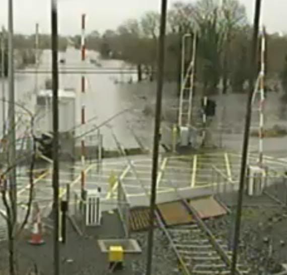
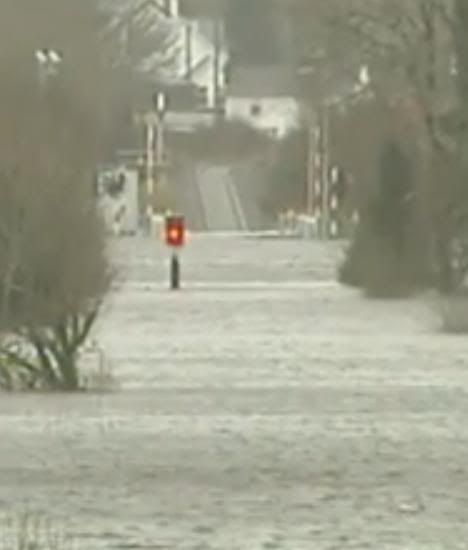
Post Flood Pictures

Options
124

Comments

  • Registered Users Posts: 1,240 ✭✭✭alibabba


    fifib wrote: »
    because of the big concrete wall they put up to seperate them from the river thats how! you can see its working!

    alibabba...isnt that house on the Lydican rd? i recognise it/always admire it..i live not too far from it. i cant believe its that high there but that area always floods. theres a two storey house across road/very close to it with a wooden fence round it and the field beside it can be flooded anytime of the year

    thats the house alright
    conflicting stories about whether that area always floods, but prob not like that kind of volume !


  • Registered Users Posts: 1,463 ✭✭✭fifib


    alibabba wrote: »
    thats the house alright
    conflicting stories about whether that area always floods, but prob not like that kind of volume !


    no but if you think of how many house have gone up in that area in the past 10-15yrs. i remember years ago my dad telling me how he remembered that area flooding really bad one year when he was a kid and wondering why they would continue to build in an area known for flooding.
    thats the worst ive ever seen it though.
    there is another road, a back road you could say behind these houses, which is also notorious for flooding and the huge houses that have gone up there in last few years...i dread to think what it looks like today


  • Banned (with Prison Access) Posts: 25,234 ✭✭✭✭Sponge Bob


    The last big flood in Claregalway was 60 years ago and certainly before they drained the Clare river in the 1960s .

    The first estate that I personally thought was a serious encroachment on the river flood plain was River Oaks and especially the second phase of that which pushed very close to the river .

    That got permission in the 1990s . I always wondered how ! Same with that concrete walled estate .


  • Registered Users Posts: 355 ✭✭greeneyedspirit


    Sponge Bob wrote: »
    The last big flood in Claregalway was 60 years ago and certainly before they drained the Clare river in the 1960s .

    The first estate that I personally thought was a serious encroachment on the river flood plain was River Oaks and especially the second phase of that which pushed very close to the river .

    That got permission in the 1990s . I always wondered how ! Same with that concrete walled estate .

    You're absolutely right, it's mindboggling, if you think about it. Adding the Friary and Cuirt na hAbhainn (sp??) to that, both of which are on floodplains, and the corporate park... it's a recipe for disaster, really.
    The fact that all of these three estates have at least been partially evacuated speaks for itsself.


  • Banned (with Prison Access) Posts: 25,234 ✭✭✭✭Sponge Bob


    BUT the volumes further downriver on the Curragh Line indicate that this is an exceptional flood, perhaps even a one in a 100 year flood , historically.

    I would blame overbuilding in Tuam as much as anything and the insistence of the council that your floor levels is at or below road level EVEN ON ON NEAR FLOODPLAINS where they should have some cop on . It also guarantees the septic tank will be submerged .
    :(


  • Advertisement
  • Registered Users Posts: 564 ✭✭✭fishfoodie


    Sponge Bob wrote: »
    BUT the volumes further downriver on the Curragh Line indicate that this is an exceptional flood, perhaps even a one in a 100 year flood , historically.

    I would blame overbuilding in Tuam as much as anything and the insistence of the council that your floor levels is at or below road level EVEN ON ON NEAR FLOODPLAINS where they should have some cop on . It also guarantees the septic tank will be submerged .
    :(

    Have a look at the pictures in this thread of the Nine Arches.

    Notice how the water level is still below the height of the arches in the current flood !

    How is it that a bridge 300+ years old is better engineered than the current one ?


  • Banned (with Prison Access) Posts: 25,234 ✭✭✭✭Sponge Bob


    Ah yeah but the pre 1960s channel was higher up than the modern northerly one by the castle and shallower , come on fishfoodie .

    Note there are no houses near the river in Claregalway that were built pre 1960 , nothing nearer than the crossroads. The whole of Claregalway village is post drainage scheme which was c.1965 .


  • Posts: 0 ✭✭ [Deleted User]


  • Posts: 5,121 ✭✭✭ [Deleted User]


    Sponge Bob wrote: »
    Ah yeah but the pre 1960s channel was higher up than the modern northerly one by the castle and shallower , come on fishfoodie .

    Note there are no houses near the river in Claregalway that were built pre 1960 , nothing nearer than the crossroads. The whole of Claregalway village is post drainage scheme which was c.1965 .
    The graveyard / abbey behind the ball alley is older than the castle AFAIK but it was on the other side of the river / an island then.

    OS map:

    http://ims0.osiemaps.ie/website/publicviewer/main.aspx#V1,537188,733161,6

    Click historic 25i in the bottom right hand corner.


  • Banned (with Prison Access) Posts: 25,234 ✭✭✭✭Sponge Bob


    The 9 arches look like an old channel that only flooded in winter , the river was beside the castle then (c 1910)

    Here is an interesting one first click this

    http://ims0.osiemaps.ie/website/publicviewer/main.aspx#V1,539330,733031,5

    Simply click between 2000 and 2005 on the bottom right !


  • Advertisement
  • Closed Accounts Posts: 6 MissThang


    Those poor people. I know that house too in Lydican.


  • Registered Users Posts: 14,166 ✭✭✭✭Zzippy


    A lot of the land that has flooded now near the Clare would have flooded every winter pre-drainage, circa 1950s. Since then, that land has by and large been flood free, and people have started building houses on what was effectively a flood plain. Unfortunately, even a drained river can only cope with so much water, and those people who built on that land are unfortunately seeing what happens. Planning in this country has been a joke for many years, maybe now the council planners will wake up and stop allowing this to happen.

    The fisheries board had to object to An Bord Pleanala about a housing development that was going up beside another river in Mayo, the developer fought it tooth and nail, but ABP eventually upheld the appeal. The developer did get permission for a neighbouring development, and guess what, he can't sell any of the ground floor apartments because the river flooded them a couple of months after completion.


  • Registered Users Posts: 751 ✭✭✭Hotwheels


    MissThang wrote: »
    Those poor people. I know that house too in Lydican.

    That is just depressing....

    96936.jpg


  • Registered Users Posts: 2,144 ✭✭✭mrsdewinter


    The graveyard / abbey behind the ball alley is older than the castle AFAIK but it was on the other side of the river / an island then.

    OS map:

    http://ims0.osiemaps.ie/website/publicviewer/main.aspx#V1,537188,733161,6

    Click historic 25i in the bottom right hand corner.

    That's extremely interesting. Clicked on Historic B&W there too - even more informative: it shows the castle standing on an island. That says it all really, doesn't it?


  • Closed Accounts Posts: 3,010 ✭✭✭Tech3


    Do you know what route this was on? Some joke everyone taking a pop trying to get through the flood


  • Registered Users Posts: 160 ✭✭extraice


    well was in North of Tenerife last week and we had a floods just few off them had , here some youtube off it , power , water was cut off , house were washed away and watch the parking off cars


    and 2nd utube will show you where the car can from , and there was a house there where water is fall is now on ther right . all down on the beach 5 km away


  • Posts: 5,121 ✭✭✭ [Deleted User]


    That's extremely interesting. Clicked on Historic B&W there too - even more informative: it shows the castle standing on an island. That says it all really, doesn't it?
    The historic B&W shows the ruined abbey is on an island - the castle is to the north side. The bit on the island is behind the ballalley / farmyard today.

    My own village looks very different (but my family farm is there at least)


  • Registered Users Posts: 602 ✭✭✭transylman


    Zzippy wrote: »
    Planning in this country has been a joke for many years, maybe now the council planners will wake up and stop allowing this to happen.

    I wouldn't blame the planners. Most of the time they take things like flood plains into account. Its just they tend to be overruled by the councilors, who for some reason want to push through these developments anyway, almost as if they stand to personally benefit from authorizing unsuitable housing. :confused:


  • Registered Users Posts: 1,101 ✭✭✭AidySevenfold


    Wow, i'm from donegal, but some of these pics are shocking. really feel for the guy with the new home.
    some pictures are scary actually :eek:


  • Registered Users Posts: 14,166 ✭✭✭✭Zzippy


    transylman wrote: »
    I wouldn't blame the planners. Most of the time they take things like flood plains into account. Its just they tend to be overruled by the councilors, who for some reason want to push through these developments anyway, almost as if they stand to personally benefit from authorizing unsuitable housing. :confused:

    Corrupt local politicians in Ireland? Nah....surely not! :rolleyes:


  • Advertisement
  • Banned (with Prison Access) Posts: 25,234 ✭✭✭✭Sponge Bob


    The planners let through a blatant flood plain jobbie in Oranmore that An Bord Pleanála overuled

    http://buckplanning.blogspot.com/2007/03/board-rejects-plan-for-housing-on-flood.html


  • Closed Accounts Posts: 369 ✭✭lala stone


    :D where is that pic taken.judging by what there drinking , it looks more like somewhere on the continent
    +1 farmers dont do long-necks


  • Registered Users Posts: 10,210 ✭✭✭✭JohnCleary


    Anyone got any pics of the Curraghline?


  • Posts: 5,121 ✭✭✭ [Deleted User]


  • Registered Users Posts: 85 ✭✭mndgz


    just saw it on facebook.
    kiltartan rd.


  • Registered Users Posts: 3,772 ✭✭✭civis_liberalis


    Where's that exactly? Beside Coole?


  • Closed Accounts Posts: 146 ✭✭Chimpster


    Where's that exactly? Beside Coole?

    The turn off for Kinvara


  • Banned (with Prison Access) Posts: 25,234 ✭✭✭✭Sponge Bob


    kt2.jpg

    kt.jpg


  • Registered Users Posts: 39 spanner555


    Some picture of Mountshannon harbour taken thurs 26/11/09 around midday.


  • Advertisement
  • Registered Users Posts: 1,240 ✭✭✭alibabba


    Sponge Bob wrote: »
    kt2.jpg

    kt.jpg

    even a submarine would struggle to get thru that
    cripes !


This discussion has been closed.
Advertisement