Advertisement
If you have a new account but are having problems posting or verifying your account, please email us on hello@boards.ie for help. Thanks :)
Hello all! Please ensure that you are posting a new thread or question in the appropriate forum. The Feedback forum is overwhelmed with questions that are having to be moved elsewhere. If you need help to verify your account contact hello@boards.ie

Potential Storm Tuesday/Wednesday - 24/25 November

Options
  • 22-11-2009 1:45pm
    #1
    Registered Users Posts: 11,134 ✭✭✭✭


    It looks like we may be in for some more windy weather next week.

    First off, Met Éireann had this to say today :
    Mild and very windy on Tuesday with scattered outbreaks of rain, heavy at times.

    At the moment, the GFS weather model is showing a windy day Tuesday for most parts followed by what could be stormy conditions later that night and into the early hours of Wednesday.

    Tuesday 12pm :

    sos5c6.png


    Wednesday 6am :

    209lv0p.png


    Still a few days away so there is plenty of time for this potential system to be more or less significant than it looks now by the time it arrives, but since it looks like there is almost certainly going to be wet/windy weather of some degree I thought it would be a good idea to have a thread dedicated to this.


«134

Comments

  • Closed Accounts Posts: 5,150 ✭✭✭Deep Easterly


    Worth keeping an eye on is right, as persistent rain is forecast once again which could lead to further problems.

    Here we go again! :p


  • Registered Users Posts: 1,519 ✭✭✭Hooter23


    Hope this next storm gets stronger as the storm we have now was bad enough in Galway anyway and the thunderstorms were exciting but I would like to see a more potent storm wind with 100mph winds:D is this a possibility with this next system I doubt it


  • Registered Users Posts: 753 ✭✭✭Timistry


    Yes! another week of crushing disappointment with regards to weather non- events:rolleyes:


  • Closed Accounts Posts: 2,039 ✭✭✭force eleven


    Timistry wrote: »
    Yes! another week of crushing disappointment with regards to weather non- events:rolleyes:

    Welcome to the world of Irish weather watching. The greatest events are always those you do not expect, in my years of experience....


  • Registered Users Posts: 11,134 ✭✭✭✭maquiladora


    The 12Z GFS shows stronger winds for the south coast & irish sea, but the west and northwest get the strongest gusts on this run.

    3am Wednesday:

    30b0eo0.png

    This run is also showing heavy rain coming into the west and south Tuesday afternoon.

    6pn Tuesday:

    2i9merc.png

    As usual, changes are to be expected...


  • Advertisement
  • Registered Users Posts: 11,134 ✭✭✭✭maquiladora


    Interesting situation here lads, the 18Z GFS is rolling out and it brings the path of the storm a little further south again and also ramps up the intensity a bit, the result of which is that more of the west, southwest and south coasts would see stronger winds. Increased winds again in the Irish Sea and inland. The rainfall amounts however look the same on this run as the last.

    If this particular run were to come off then this storm would probably be more severe than this weekends one and would be felt over a wider area.

    11tsmyg.png

    21o0eur.png

    2zxpbns.png

    o5qem1.png


    As always, important to remember this is just one model and could very well be less or more severe in the end, but 2 days isnt too far away so these runs should be getting more accurate.

    Looking forward to seeing what M.T. thinks.


  • Registered Users Posts: 14,517 ✭✭✭✭M.T. Cranium


    I think I'll take three days off. :D

    Seriously, this looks about the same net result as Sunday's storm (?) with the northwest showing the strongest wind gradients, but the south coast getting the first round on Tuesday.

    We'll have to keep an eye on it next few runs, and see if it wants to intensify, anything weaker would just end up being an outer coast minor event, anything stronger and it could be more noteworthy than Sunday.


  • Closed Accounts Posts: 5,150 ✭✭✭Deep Easterly


    Lets hope this one throws a bit more wind inland than today's forgettable event. I actually recorded higher windspeeds in July this year than at any stage today. :pac:


  • Registered Users Posts: 2,677 ✭✭✭Rougies


    Lets hope this one throws a bit more wind inland than today's forgettable event. I actually recorded higher windspeeds in July this year than at any stage today. :pac:

    Hopefully. The wind today was pathetic considering the charts and warnings etc. I'm sure my farts gusted higher and were definitely more destructive!


  • Registered Users Posts: 3,087 ✭✭✭Duiske


    The low that passed today seems to move on pretty quickly (over scandinavia by this time tomorrow night) but tuesdays low looks forecast to hang around just to the north of Scotland up to, and maybe beyond, the weekend, dragging in stiff westerlies at first and veering more northerly as the week goes on. Possibly some wintry conditions on the way by the weekend for the NW ?

    The first of tonights rain is just appearing off the SW coast on the Met radar. Hopefully the strong winds will push it on quickly before it adds to Munsters problems.

    Web_radar.gif


  • Advertisement
  • Registered Users Posts: 7,092 ✭✭✭pauldry


    Yes while Cork has seen over 200mm of rain in November Sligo has seen an average of 11mm a day in November so far with a total of 258mm:eek: I estimated a the start of November when we got 30mm on day one here that we would end up with 300mm. I though I was exageratting a bit then but now it looks a reality! Ill let ye know our final figure here in the Northwest.


  • Registered Users Posts: 11,134 ✭✭✭✭maquiladora


    An update from Met Eireann :
    TUESDAY NIGHT and WEDNESDAY will be very windy or possibly even stormy, with west to southwest winds gusting from 90 to 120 kph, strongest along the western seaboard. There will be blustery heavy showers of rain or hail throughout the period.

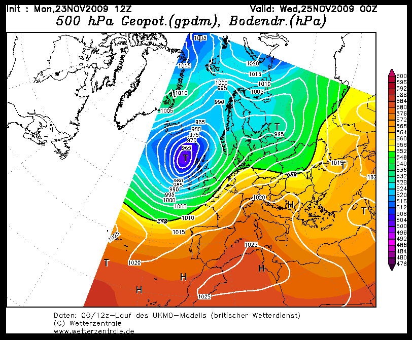
    And here is the UKMO chart for midnight Tuesday :

    9hj8dw.gif


  • Registered Users Posts: 11,134 ✭✭✭✭maquiladora


    06Z GFS is rolling out and it looks like it hasn't changed much from the charts I posted last night so I won't bother posting the local wind charts, looks very similiar to my eyes anyway....

    2ujidzb.png


  • Closed Accounts Posts: 5,150 ✭✭✭Deep Easterly


    pauldry wrote: »
    Yes while Cork has seen over 200mm of rain in November Sligo has seen an average of 11mm a day in November so far with a total of 258mm:eek: I estimated a the start of November when we got 30mm on day one here that we would end up with 300mm. I though I was exageratting a bit then but now it looks a reality! Ill let ye know our final figure here in the Northwest.

    Amazing figure Paul, and exactly the same here in Galway at 258.8mm. It is debatable as to whether 300mm can be achieved before November is over but it will be interesting to see whether it does or not.


  • Registered Users Posts: 589 ✭✭✭kerry1960


    Amazing figure Paul, and exactly the same here in Galway at 258.8mm. It is debatable as to whether 300mm can be achieved before November is over but it will be interesting to see whether it does or not.

    Only 14mm short of that 300mm mark , depressing .


  • Registered Users Posts: 11,134 ✭✭✭✭maquiladora


    http://www.xcweather.co.uk/GB/forecast

    Click on Wednesday 06:00, looks like thats the peak time for winds in most places. 83 kmph winds sustained over Dublin, 93 kmph sustained off the northwest coast. Gusts would be about 30% higher right?


  • Registered Users Posts: 11,134 ✭✭✭✭maquiladora


    Weather Warning

    Issued at 23 November 2009 - 13:15

    Weather Warning

    Turning very windy tonight and tomorrow with further spells of heavy rain, giving 15 to 25 mm in places.

    http://www.met.ie/forecasts/warnings.asp


  • Closed Accounts Posts: 5,150 ✭✭✭Deep Easterly


    kerry1960 wrote: »
    Only 14mm short of that 300mm mark , depressing .

    This month is turning out to be a little bit on the damp side alright.


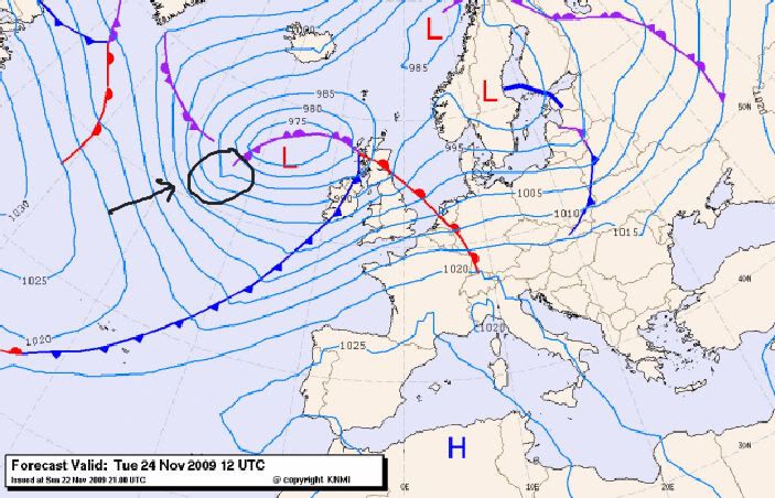
    Latest frontal analysis charts show tomorrow's set up nicely:

    Potentialinstability.jpg
    Image Source: http://www.knmi.nl/


    I just circled the area where that potential bank of instability is forecast to develop and potentially bring us the strongest winds of this latest spell either late Tuesday night or sometime during Wednesday morning. Could be some heavy showers embedded too if all goes according to plan. However, nothing set in stone yet and things may change as per the Irish weather :o


  • Registered Users Posts: 11,134 ✭✭✭✭maquiladora


    12Z GFS run weakens the intensity of the winds but seems to increase rainfall over Tues/Wed.

    Meanwhile, here is the latest UKMO Fax for midnight tomorrow :

    16i5ok6.gif


  • Closed Accounts Posts: 5,150 ✭✭✭Deep Easterly


    Latest UKMO release seems to comply with the Fax chart posted above:

    Rukm361.gif

    Are we looking at some sort of squall line rumbling its way over Ireland in the small hours Wednesday morning? :confused: Certainly, going by the latest outputs, the worst of the winds seem to be destined for the North and North-West as this feature passes over.


  • Advertisement
  • Registered Users Posts: 332 ✭✭howlinwolf


    i see met eireann has increased its strength in wind speed for tomorrow evening and tomorrow night .... from 100km gusts,now up to 130km gusts in the west and north.....although thursdays storm was more hyped does anyone think this has the potenial to be stronger.....i was reading somewhere that this one is deepening as it moves nearer.....:confused:

    it doesnt look to be of the same intensity on the sat images yet


  • Closed Accounts Posts: 5,150 ✭✭✭Deep Easterly


    howlinwolf wrote: »
    i see met eireann has increased its strength in wind speed for tomorrow evening and tomorrow night .... from 100km gusts,now up to 130km gusts in the west and north.....although thursdays storm was more hyped does anyone think this has the potenial to be stronger.....i was reading somewhere that this one is deepening as it moves nearer.....:confused:

    it doesnt look to be of the same intensity on the sat images yet

    The system that is forecast to bring those strong winds tomorrow night has yet to develop so anything could happen really. It really is an off shoot of the parent low that is heading this way. In other words, a developing trough that could bring some very squally showers with very gusty winds overland before pressure begins to rise behind it sometime early Wednesday.

    Again, none of this may actually come to fruition but it is interesting to watch how this develops from a weather point of view.

    Edit: This satellite run from yr.no is a good site to monitor short wave developments over the last 24hrs which might come in useful over the next day or so:

    http://www.yr.no/satellitt/1.5941760


    It is a good way to monitor the weather over Europe full stop :)


  • Registered Users Posts: 11,134 ✭✭✭✭maquiladora


    howlinwolf wrote: »
    it doesnt look to be of the same intensity on the sat images yet

    As yet there is no image to look at that tells anything, you wont see that until closer to the event.

    It does have the potential to be stronger than the weekends storm, but it also has the potential to be weaker. Half of the fun is not knowing exactly what will happen. :pac:


  • Registered Users Posts: 11,134 ✭✭✭✭maquiladora


    An updated warning...

    Issued at 23 November 2009 - 18:15

    Weather Warning

    Very windy later tonight and for Tuesday with further spells of heavy rain, with some further flooding likely. Strong southerly winds will gust 85 to 100 km/h in places.

    Stormy tomorrow evening and tomorrow night, with gusts of 120 to 130 km/h in parts of the West and North. Heavy squally and possibly thundery showers also.

    Overall, rainfall totals 25 to 35 mm , highest in Southwest, West and North.


  • Registered Users Posts: 6,186 ✭✭✭munsterlegend


    An updated warning...

    they are very on the ball at the moment with their warnings - 35mm is a lot of rain. doesn't look that much forecasted i thought previously - is there some new info to hand?


  • Registered Users Posts: 11,134 ✭✭✭✭maquiladora


    Related news...


    Flood warning issued for Co Clare

    Monday, 23 November 2009 20:12

    Parts of Co Clare are on high flood alert because of increasing water levels in the river Shannon.

    The areas concerned are O'Briensbridge, Clonlara, Westbury and Shannon Banks.

    The ESB has been forced to release a significant amount of water at the Parteen Weir due to rising water levels in the River Shannon.

    The move means that areas downstream from Parteen, including Limerick city, can expect higher water levels.


  • Registered Users Posts: 2,904 ✭✭✭cian1500ww


    Will we get the same kind of day we had last Thursday this week ?


  • Registered Users Posts: 14,517 ✭✭✭✭M.T. Cranium


    I agree 30-40 mms potential with this rainfall event, and 65-70 knot wind gust potential for Connacht overnight Tues-Wed. This would make both cases about equal (or just less perhaps) than the recent rain and wind events on the two separate occasions, but bearing in mind that there was generally 20-30 mms of rain over the weekend too, this next wallop is going to stress the overloaded drainage systems severely.


  • Registered Users Posts: 11,134 ✭✭✭✭maquiladora


    The ESB are under severe pressure dealing with the Shannon at the moment, having to release more and more amounts of water, and this even before the expected 30 odd mm coming over the next couple of days...


  • Advertisement
  • Registered Users Posts: 11,134 ✭✭✭✭maquiladora


    18Z GFS appears to be another minor downgrade on previous runs...

    2qwd7pe.png


Advertisement