Advertisement
If you have a new account but are having problems posting or verifying your account, please email us on hello@boards.ie for help. Thanks :)
Hello all! Please ensure that you are posting a new thread or question in the appropriate forum. The Feedback forum is overwhelmed with questions that are having to be moved elsewhere. If you need help to verify your account contact hello@boards.ie

Oddities of Irish Infrastructure

Options
123457»

Comments

  • Registered Users Posts: 2,630 ✭✭✭Plowman


    This post has been deleted.


  • Closed Accounts Posts: 8,048 ✭✭✭Amazotheamazing


    Plowman wrote: »
    This post has been deleted.

    cheers for fixing the photo, it was built like that because the river passes through a deep gorge apparently. Strange little place, it's not my photo but I've tracked the place down. No signs for it, no place to park and you've to walk through a field to get to the river bed but nice spot when you get to it. It's on the backroad into Lisdoonvarna coming from Doolin, iirc.


  • Registered Users Posts: 1,492 ✭✭✭upmeath


    Colm R wrote: »
    Is there a massive change in the distance to Ballyshannon leaving Navan on the old N3. Not sure of the signs are still there, but I believe on the 3 distance signs going out of Navan, Ballyshannon was indicated to be, 1st 80, then 160, then 120.

    My numbers might not be correct but it was something like that.

    I'm not sure if that's still there. I used to travel the Navan-Kells road daily last year on my way to and from work. I noticed the Kells distance shift almost immediately when I started using the road, but I never saw anything wildly wrong about the Ballyshannon distances. Either it's been removed or replaced. And given the huge differences in distances you're talking about there (I know your figures are only guesses, but still they're pretty abstract from one another) the smaller figures may have been miles and the new ones are kilometres? Just a thought.


  • Registered Users Posts: 757 ✭✭✭Jayuu


    upmeath wrote: »
    On the old N3, travelling north leaving Navan, the roadsigns forecast a distance of 15km to Kells. A few hundred metres out the road (after the level crossing) Kells has mysteriously distanced itself from Navan, now registering at a distance of 16km.

    I noticed this discrepancy last week when I was running late on my way to Kells.

    I also wonder whether the distance signs on some of the older sections of our motorways are still accurate given that they were put in place before the newer sections came on stream.


  • Registered Users Posts: 606 ✭✭✭time lord


    The N52 approx 6-7 miles south of Mullingar gives priority to a minor road.
    If traveling south one must indicate off the n52 to stay on the N52.
    If traveling north one must indicate right and wait untill clear before continuing on to the N52.
    The n52 carrys a far superio no. of vehicles yet the minor road with the locals gets the drive through.
    It only needs some paint and movement of signs to sort out!
    Cost trucks and cars time needlessly every hour of every day.


  • Advertisement
  • Closed Accounts Posts: 7,397 ✭✭✭Paparazzo


    For some reason Naul gets mentioned on M50 signposts. It's included on the ballymun exit. Naul is a small village about 20 miles north, does it get many tourists? Why is it signposted from the m50? Ironicly, if you were going there you would take the next exit, the M1.


  • Closed Accounts Posts: 4,725 ✭✭✭charlemont


    Paparazzo wrote: »
    For some reason Naul gets mentioned on M50 signposts. It's included on the ballymun exit. Naul is a small village about 20 miles north, does it get many tourists? Why is it signposted from the m50? Ironicly, if you were going there you would take the next exit, the M1.

    its for when joe o reilly gets out in about 15 years he wont be lost...

    actually kanturk is the same down here its signposted all around the ballincollig bypass which is only sending people on a twisty R road, over the mountains , rather than use n20 to mallow then n72 to kanturk, which is the more logical way..and quicker..


  • Closed Accounts Posts: 17,733 ✭✭✭✭corktina


    Kanturk to Ballincollig 45 minutes via Nadd...if you go via Mallow you will only make Blackpool in that time so the R road is quicker and is the historic road for Kanturk anyway. It's not a great road but isnt too bad, you can maintain 80k quite comfortably over most of it.


  • Closed Accounts Posts: 10,025 ✭✭✭✭-Corkie-


    corktina wrote: »
    Kanturk to Ballincollig 45 minutes via Nadd...if you go via Mallow you will only make Blackpool in that time so the R road is quicker and is the historic road for Kanturk anyway. It's not a great road but isnt too bad, you can maintain 80k quite comfortably over most of it.

    Nad is quicker as long as you dont get stuck behind a Ducons truck..


  • Registered Users Posts: 757 ✭✭✭Jayuu


    Paparazzo wrote: »
    For some reason Naul gets mentioned on M50 signposts. It's included on the ballymun exit. Naul is a small village about 20 miles north, does it get many tourists? Why is it signposted from the m50? Ironicly, if you were going there you would take the next exit, the M1.

    From what I can see on the map, the road you get onto from the Ballymun exist is the R108. This first goes to Naul and then eventually goes to Drogheda. However it would be madness to signpost the road as Drogheda. So in order not to have a blank signposted exit, they obviously chose Naul even though it's a tiny village.


  • Advertisement
  • Registered Users Posts: 549 ✭✭✭unit 1


    OK so castlebar (mayo) to Galway.
    Using national primary n60 to claremorris and n17 from there. Journey time about 1hr 20min, or alternatively, the signposted way, a worse route (as in road) the n84 through ballinrobe (yield to minor local road in town:D), journey time 1hr 15.
    Now the way everyone with sense uses is castlbar, ballinrobe, then use the r334 to headford then galway, journey time 1hr 10.:rolleyes:


  • Registered Users Posts: 24,506 ✭✭✭✭Cookie_Monster


    Only a small one but
    Backraods into Gorey from Ballymoney has Gorey signposted as 5km, exactly a km later it posted as 6km.

    In the 15 years its been there they've never thought to swap them :)


  • Registered Users Posts: 135 ✭✭ForiegnNational


    Sign on the N71, just south of the N25 South Ring, Bandon Road roundabout, states Bandon is 33km.

    A subsequent distance sign at Halfway (10km from the first), then states correctly that Bandon is 14km.

    The actual distance is 25km, giving an overstatement of 25% on the first sign!


  • Registered Users Posts: 3,878 ✭✭✭whyulittle


    Probably brought up before, but it has always bugged me.

    Coming out of Dublin on the M4, Sligo and Galway are both signposted as the same distance. Yet 10 minutes down the road, there is magically an 8km difference!


  • Registered Users Posts: 757 ✭✭✭Jayuu


    Given these discrepancies in distance signage can I ask is it the NRA who have responsibility for signage on our road network or is it done at a local level?


  • Registered Users Posts: 8,826 ✭✭✭SeanW


    I don't know if this has featured on thread so far, but on the N1 dual carriageway, Exit 20 Northbound, Jonesborough, the slip road traverses 2 countries! At that point, the N1 DC runs so close to the border along the side, that it is impossible to have a Northbound slip at that point without crossing the border.

    You can see it, on a map, and in Street View here: At the end of the Street View data, just inside the border on the Republican side, you can clearly see that you're in the Republic, look at the Amach sign and the yellow side road markings. But keep going up the Street View data and you see the border and transition to British standard road signs/markings, before the slip has finished.

    I would certainly consider this an "oddity" and I wonder if there are other cases like that in Europe or the world?


  • Registered Users Posts: 7,476 ✭✭✭ardmacha


    just inside the border on the Republican side,

    As if the Armagh side of this join in the tarmac was less republican than the Louth side!!!!
    I would certainly consider this an "oddity" and I wonder if there are other cases like that in Europe or the world?

    Europe has all sorts of oddities.


  • Registered Users Posts: 6,995 ✭✭✭Sofiztikated


    Don't know if this is the correct place to put this, but Ballinagh, in Cavan, is signposted as both Ballinagh, and Bellananagh on sign posts.

    If you travel on the N55, you'll see it as sign posted as Ballinagh. Travel on the R198 out of Cavan to Crossdoney, and its signposted as Bellananagh.

    Confussling.


  • Registered Users Posts: 742 ✭✭✭garbanzo


    In most other proper countries the local authorities actually wash and clean the road signs to keep them legible. Some of the signs you come across on the roadsides of Ireland are utterly manky and illegible.

    On a similar note, I live and work in Dublin and the quality of street signage is also an embarrassment. You can't work out what street you are on because either a) the - usually green - road sign has totally weathered and you can't read it or b) no one has been arsed to re paint the - usually blue - signs which have also weathered. What sorts of fcukwits are responsible for this?

    At a minimum it makes us look like a shabby third world country (i know!!) but god help anyone unfamiliar with the city trying to make their way about the place. Really, really boils my piss.....!
    :mad:


  • Banned (with Prison Access) Posts: 25,234 ✭✭✭✭Sponge Bob


    garbanzo wrote: »
    In most other proper countries the local authorities actually wash and clean the road signs to keep them legible. Some of the signs you come across on the roadsides of Ireland are utterly manky and illegible.

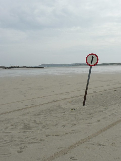
    You should move to the Wesht so. We make sure this here roadsign is maintained in pristine condition.....except....

    Omey1.jpg

    Maybe they should straighten it a tad and paint the base??

    4553719377_fc61f33535_z.jpg


  • Advertisement
  • Registered Users Posts: 549 ✭✭✭unit 1


    Just curious but what exactly is km/hr in irish, and if it's different does that mean that those in gaeltacht areas are incorrect, as they should be in proper irish. (a nice loophole for penalty points:D)


  • Registered Users Posts: 742 ✭✭✭garbanzo


    Sponge Bob wrote: »
    You should move to the Wesht so. We make sure this here roadsign is maintained in pristine condition.....except....

    Omey1.jpg

    Maybe they should straighten it a tad and paint the base??

    4553719377_fc61f33535_z.jpg

    Great post spongebob. Fair play to ye guys out wescht. Cleaned twice a day. Yisser surely on the ball.


  • Registered Users Posts: 1,021 ✭✭✭Sulmac


    unit 1 wrote: »
    Just curious but what exactly is km/hr in irish, and if it's different does that mean that those in gaeltacht areas are incorrect, as they should be in proper irish. (a nice loophole for penalty points:D)

    'km/h' is the official SI unit symbol for 'kilometres per hour' in every language.

    For instance, in German it is Kilometer pro Stunde but the official unit symbol is still km/h.

    In Irish it is ciliméadar san uair, since you were wondering. :D


  • Registered Users Posts: 369 ✭✭Empire o de Sun


    It's French

    Kilomètre par heure :D


  • Registered Users Posts: 2,153 ✭✭✭bkehoe


    SeanW wrote: »
    I would certainly consider this an "oddity" and I wonder if there are other cases like that in Europe or the world?

    On the A7 (NL) - 280 (DE) or E22 at the Dutch/German border there is a small services area.

    Anyway as you approach the German border you see the sign for services. So as soon as you take the slip road you enter Germany (and the service station, restaurant, etc is in Germany). Even stranger is a big German police station too. Then follow the exit signs and re-enter the motorway and you're back in Holland!

    When I was first there I was puzzled how the only access to a German police station could be through Holland though when I looked at google maps there now I see there is a small link road from the german side for access!


  • Registered Users Posts: 8,826 ✭✭✭SeanW


    Here that is on the map:
    http://maps.google.com/?ie=UTF8&ll=53.178051,7.218415&spn=0.00281,0.006899&z=17

    Interesting. If you go back into Holland a bit, you find that the final junction in the Netherlands is at the start of the final ~1km or so of the A7. In building it, the Dutch cut it fine building the Germany bound onramp close to the A7 itself to avoid a Holland-Germany-Holland(-Germany) situation, similar to what you would have in Ireland if you had got off the N1 Northbound at J20 and "doubled back" South.

    http://maps.google.com/?ie=UTF8&ll=53.176617,7.204585&spn=0.00562,0.013797&z=16


  • Registered Users Posts: 21,464 ✭✭✭✭Alun


    Sulmac wrote: »
    'km/h' is the official SI unit symbol for 'kilometres per hour' in every language.
    [rant]
    Yes, and not kph, kmph, km/ph, km/p/h or whatever other monstrosity posters here on Boards, or even local authorities care to invent.
    [/rant]


Advertisement