Advertisement
If you have a new account but are having problems posting or verifying your account, please email us on hello@boards.ie for help. Thanks :)
Hello all! Please ensure that you are posting a new thread or question in the appropriate forum. The Feedback forum is overwhelmed with questions that are having to be moved elsewhere. If you need help to verify your account contact hello@boards.ie

The Wicklow photo thread - old and new [No Chat]

Options
13

Comments

  • Registered Users Posts: 9,936 ✭✭✭LEIN


    1012654_691659107540678_1222061530_n.jpg


  • Closed Accounts Posts: 13,549 ✭✭✭✭Judgement Day


    Naylor's+Cove+Valentines+pc+dated+1896.jpeg

    Came across this ancient Valentine's postcard today - Naylor's Cove, Bray in 1896 - before the development of the swimming pools. It's almost back to this appearance today.


  • Registered Users Posts: 6,250 ✭✭✭pixbyjohn


  • Registered Users Posts: 1,466 ✭✭✭vickers209


    Rathnew train station robbed from facebook

    10501894_745871298807379_1148594133998346595_n.jpg


  • Closed Accounts Posts: 6,824 ✭✭✭Qualitymark


    And afterwards:


  • Advertisement
  • Registered Users Posts: 1,677 ✭✭✭Aenaes


    Old Castlemacadam church outside Avoca.


  • Closed Accounts Posts: 13,992 ✭✭✭✭recedite


    Aenaes wrote: »
    Old Castlemacadam church outside Avoca.
    A nice place to stop for a while with a flask of tea, of you are passing. Being up on a height, there is a good chance of seeing the Red Kites flying past as they patrol along the river valley.


  • Registered Users Posts: 6,250 ✭✭✭pixbyjohn


    15811018111_5c48a65c9f_c.jpgBray Seafront by pixbyjohn, on Flickr


  • Closed Accounts Posts: 1,199 ✭✭✭hollster2


    Arklow


  • Registered Users Posts: 6,250 ✭✭✭pixbyjohn


  • Advertisement
  • Registered Users Posts: 12,363 ✭✭✭✭Del.Monte


  • Registered Users Posts: 14,928 ✭✭✭✭loyatemu


    Del.Monte wrote: »
    Glen%2Bof%2Bthe%2BDowns%2B1918.JPG

    "North Bray"? They're holding their map upside down.


  • Registered Users Posts: 12,363 ✭✭✭✭Del.Monte


    The Rocky Valley Drive in 1905 - doesn't appear to be much more than a track. :D

    Eock%2BValley%2BDrive.PNG


  • Closed Accounts Posts: 13,992 ✭✭✭✭recedite


    I wonder is that postcard of The Long Hill, the main road. It looks like this spot. https://www.google.ie/maps/@53.1679871,-6.1596146,3a,75y,90h,90t/data=!3m6!1e1!3m4!1seKDFT7QTY6FRw9pIAYPaOA!2e0!7i13312!8i6656
    AFAIK there is some kind of holy grotto in the field around there nowadays, would that be connected with the "wishing well" mentioned in the handwriting?


  • Registered Users Posts: 6,250 ✭✭✭pixbyjohn


  • Registered Users Posts: 6,250 ✭✭✭pixbyjohn


  • Registered Users Posts: 6,250 ✭✭✭pixbyjohn


  • Registered Users Posts: 12,363 ✭✭✭✭Del.Monte


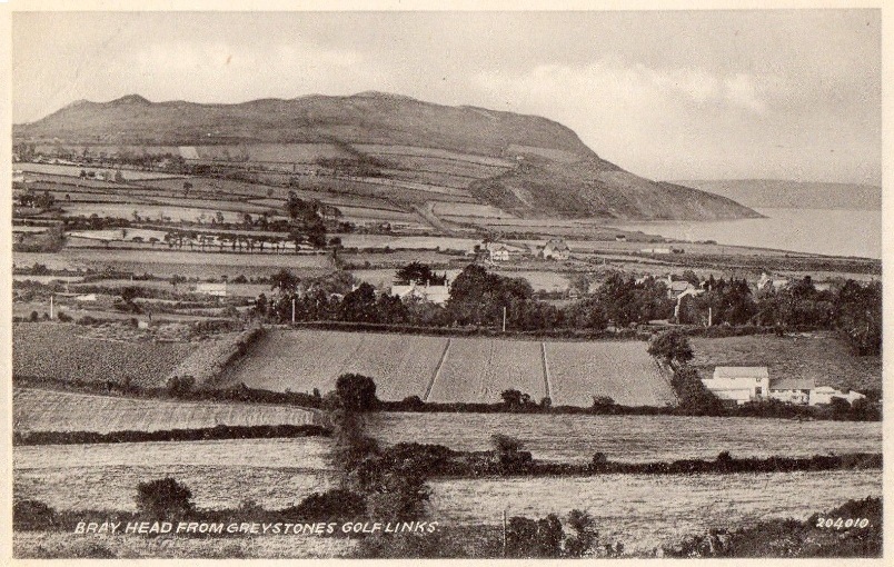
    Bray%2BHead%2Bfrom%2BGreystones%2BVALENTINES%2Bpc%2B-%2BCopy.jpg

    Interesting 1940/50s (?) Valentines postcard view of Bray Head from Greystones Golf Links. Can't place the view as all I see is Greystones from the train these days - I presume a lot of this land is built over?


  • Registered Users Posts: 14,928 ✭✭✭✭loyatemu


    Del.Monte wrote: »
    Interesting 1940/50s (?) Valentines postcard view of Bray Head from Greystones Golf Links. Can't place the view as all I see is Greystones from the train these days - I presume a lot of this land is built over?

    All of it - the fields in the foreground are now Hillside and Heathervue estates, beyond that Rathdown Park etc. I think that photo is older than 1940s but it's hard to tell.


  • Advertisement
  • Registered Users Posts: 2,427 ✭✭✭tc20


    loyatemu wrote: »
    All of it - the fields in the foreground are now Hillside and Heathervue estates, beyond that Rathdown Park etc. I think that photo is older than 1940s but it's hard to tell.

    do you know if the farmhouse in the right hand foreground is still there (I'm trying to place where that is now (the bend on Hillside Road?)
    Also the couple of houses poking through the trees above (again on the right hand side of the photo) - is that around New Road?


  • Registered Users Posts: 14,928 ✭✭✭✭loyatemu


    tc20 wrote: »
    do you know if the farmhouse in the right hand foreground is still there (I'm trying to place where that is now (the bend on Hillside Road?)
    Also the couple of houses poking through the trees above (again on the right hand side of the photo) - is that around New Road?

    From drawing a line between the POV of the photographer (which I think is somewhere around the old first tee on the golf course) and the highest point on Bray Head (where the trig point is) I reckon that's Knockrath House in the centre of the picture, which is currently for sale and the ad says it dates from 1893:
    http://www.sherryfitz.ie/residential/for-sale/84019

    the farmhouse may be the one for Hillside Farm, which I think is now gone. The houses behind that include St. Patricks Church and Knockdolian which are on Church Lane, so i guess that's the row of lamp posts running across the middle of the photo. I think by the 1940s there would have been more buildings in this picture but I could be wrong.


  • Registered Users Posts: 2,427 ✭✭✭tc20


    @ loyatemu - yes, I reckon you're spot on with the Church Lane houses, and agree with you, the photo must be well before the 40s/50s; quite a bit as there's not much of the late Victorian housing stock in view. The golf club was founded in 1895, (thank you google!) I wonder what is the large house that appears in the centre right of the photo (a smaller one to the left as you look) - perhaps this is on New Road?


  • Registered Users Posts: 14,928 ✭✭✭✭loyatemu


    tc20 wrote: »
    @ loyatemu - yes, I reckon you're spot on with the Church Lane houses, and agree with you, the photo must be well before the 40s/50s; quite a bit as there's not much of the late Victorian housing stock in view. The golf club was founded in 1895, (thank you google!) I wonder what is the large house that appears in the centre right of the photo (a smaller one to the left as you look) - perhaps this is on New Road?

    I looked at the OSI map from around the turn of the century - based on the field patterns the photo has a very compressed perspective with a narrow field of view.

    The farm buildings aren't actually Hillside Farm (which was as you say on the corner of what is now Hillside Road) but something else in the middle of what is now Hillside estate (they are marked on the map but not as extensive as in the photo).

    The houses in the distance probably are somewhere around New Road.

    452844.png


  • Closed Accounts Posts: 13,992 ✭✭✭✭recedite


    loyatemu wrote: »
    I reckon that's Knockrath House in the centre of the picture, which is currently for sale and the ad says it dates from 1893:
    http://www.sherryfitz.ie/residential/for-sale/84019
    If you scroll through the photos in the add, there is a nice shot of the newel post at the bottom of a staircase, engraved with "1893".
    tc20 wrote: »
    The golf club was founded in 1895, (thank you google!) I wonder what is the large house that appears in the centre right of the photo (a smaller one to the left as you look) - perhaps this is on New Road?
    Yes I think this photo must have been taken soon after the "golf links" opened. That house looks to be a similar style and position to Brady's shop, which I think is a more modern building. I wonder if somebody could have knocked and replaced an older structure on the same site at some stage?
    The smaller one to the left could be Trenarren? Which is in apartments these days.


  • Registered Users Posts: 6,250 ✭✭✭pixbyjohn


  • Registered Users Posts: 6,250 ✭✭✭pixbyjohn


    30187210847_14fb9498cb_c.jpgLorna Mallick, Wicklow Rose pulling a pint in Mickey Finn's Pub. Redcross by Pixbyjohn, on Flickr

    Lorna Mallick, 2018 Wicklow Rose pulling a pint at Wicklow Brewery in Mickey Finn's Pub. Redcross


  • Registered Users Posts: 1,003 ✭✭✭Zoo4m8


    Del.Monte wrote: »
    Bray%2BHead%2Bfrom%2BGreystones%2BVALENTINES%2Bpc%2B-%2BCopy.jpg

    Interesting 1940/50s (?) Valentines postcard view of Bray Head from Greystones Golf Links. Can't place the view as all I see is Greystones from the train these days - I presume a lot of this land is built over?

    First off, apologies being late to this, I don’t look in here very often but I thought one or two might be interested in an explanation of the buildings in the photo.
    As already decided it’s a view across Hillside farm to Church Lane with houses Knockrath and Rathlahine prominent, the houses in the distance are on the New Road,
    Hillside farm was originally three small farms and the buildings in the foreground was the yard belonging to one (I don’t know where the dwelling was) this yard would have been on the west side of the green in Hillside estate.
    A couple small buildings can be seen in the left hand corner near the OSI logo on the map in post 85 this was known as Cullens farm and again I don’t know where the dwelling was and this was about where the recycling center is in Tesco car park, and the third farm was of course Hillside itself and was demolished with the other buildings in the mid seventies during construction of the estate.


  • Advertisement
  • Registered Users Posts: 2,427 ✭✭✭tc20


    ^ to add more mischief; (and I meant to mention this in my previous post relating to this photo) there is a fine old house at the end of the Bellevue Park cul de sac which (to me at least; I could be wrong..) has the proportions of a period farmhouse.
    It is accessed from Church Road, but can be clearly seen beside 1 Bellevue Park. The house in question doesn't resemble any of the buildings in the right hand foreground in the photo, and at a guess I'd say it would appear slightly further off to the right of the photo. Could this also have been related to Hillside Farm?


Advertisement