Advertisement
If you have a new account but are having problems posting or verifying your account, please email us on hello@boards.ie for help. Thanks :)
Hello all! Please ensure that you are posting a new thread or question in the appropriate forum. The Feedback forum is overwhelmed with questions that are having to be moved elsewhere. If you need help to verify your account contact hello@boards.ie

N25 - Dungarvan Outer Bypass

Options
  • 17-05-2010 2:24pm
    #1
    Registered Users Posts: 1,105 ✭✭✭


    The emerging preferred route for this scheme has been chosen via the zombie Tramore House RDO, and is detailed here:
    N25/E30 Dungarvan Outer Bypass

    Introduction

    The N25 is a National Primary Route from Cork to Rosslare Harbour, which connects destinations such as Cork, Midleton, Youghal, Dungarvan, Waterford, New Ross, Wexford and Rosslare and also interlinks with other national, regional and local road networks. As part of the Atlantic Corridor Waterford County Council in partnership with the National Roads Authority is promoting a scheme to upgrade approximately 16km of the N25/E30 National Primary Route around Dungarvan.
    Here you can download a PDF of the public display document Emerging Preferred Route - Public Display May 2010 (2,958 kbs)
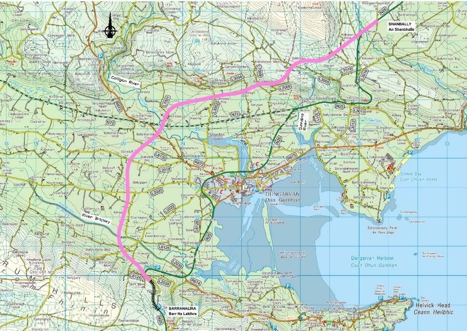
    This route travelling from west to east commences on the existing N25 in the townland of Barranalira approximately 5 km southwest of Dungarvan. It then continues in a northerly direction. The route meets the R672 in the townland of Ballymacmague South and further on the N72. The route then continues in a north-easterly direction. It then joins the existing N25 in the townland of Shanbally approximately 7 km north east of Dungarvan town.
    The purpose of this Public Consultation is to invite comments on the Emerging Preferred Route. It should be noted that the route is not fixed or final and may be subject to change during future stages of design. Your comments can be recorded by completing and returning the questionnaire to the address overleaf.
    Need for the Scheme

    The need to upgrade the N25/E30, as part of the Atlantic Corridor, has been identified in Transport 21, the National Development Plan, the National Spatial Strategy and the Dungarvan Town and Waterford County Development Plans.
    This section of the N25 is a single carriageway road with hard shoulders of various widths and climbing lanes. Safe overtaking opportunities are restricted due to alignment, minor junctions, private accesses and busy period traffic. A dual carriageway would be safer and would lead to significantly shorter travel times. The section of the N25/E30 at the Pike has been identified by the NRA as a high accident location (NRA High Accident Locations, 1996-2000). Predicted traffic volumes east & west of Dungarvan are at levels which are above the design capacity of the existing cross-section of the N25/E30 to give the required Level of Service. Subsequently the Level of Service is below the minimum set down in government policy in the National Road Needs Study and recent National Development Plan (2007-2013). The N25/E30 Dungarvan Outer Bypass must be to dual carriageway standard to achieve the level of service on the network and Department of Transport policy for the Atlantic Corridor, that all new build sections of the route must be dual.
    Why Option 6.1?

    Overall Route Option 6_1 (the Emerging Preferred Route Corridor) has been determined to be the most appropriate route corridor for the development of the scheme following appraisals in terms of environmental, engineering impacts, traffic and economics.
    Many different aspects have been taken into account during the route option appraisal, these include, in no particular order:
    • Archaeology and Built Heritage
    • Air Quality, Noise and Vibrations
    • Landscape and Visual
    • Hydrology and Drainage
    • Engineering Aspects
    • Land Use and Land Take, including impacts on Agriculture, Planning, Socio-Economics, Residential and other Property
      Geology and Hydrogeology
    • Ecology, Natural Environment and Biodiversity
    • Traffic Flows and Forecasts
    • Scheme Economics
    • Safety such as potential for accident reduction and security of pedestrians and cyclists
    The Route Selection Report which contains the appraisal results is currently being finalised. The Emerging Preferred Route Corridor may be subject to change during future stages of design.
    Environmental Appraisal: it is clear for ecological reasons Routes 4, 7, 9 and 10 are likely to have significant impacts, therefore this group of routes should not be brought forward. Of the remaining routes, none of the topics identified any major constraining factors and all routes could all potentially be taken forward for consideration at EIA stage. In terms of overall environmental impact route option 6_1 performed best.
    Engineering Appraisal: the engineering appraisal indicates that all eleven route options are feasible in terms of construction. Overall route option 6_1 was judged the most preferred route option after appraisal.
    Economic Appraisal: the economic appraisal indicates that route option 6_1 has the best positive Benefit to Cost Ratio. It is therefore economically viable.
    Options Considered

    All options considered generally follow the same broad outlines. Travelling from west to east they commence on the existing N25/E30 in the townland of Barranalira approximately 5 km southwest of Dungarvan town. The routes head in a northerly direction, crossing the Brickey River. The routes cross both the N72 and the R672 before continuing in a northerly, easterly or north-easterly direction, depending on which option. Three further rivers are crossed the Colligan, Glendine and Dalligan before the routes rejoin the existing N25/E30, either in the townland of Shanbally approximately 7 km north east of Dungarvan or in the area known as the Pike. Please click on the image above to get a larger view. Below is a summary of each routes length, type, and road and river crossings.

    Route Option 1
    The length of this route option, including an upgrade to dual carriageway type 2 of the existing N25/E30 between Barranalira and Windgap, is 15.59 km and it will cross 17 local roads, 1 regional road, 1 national secondary road and 4 rivers.
    Route Option 2
    The length of this route option, including an upgrade to dual carriageway type 2 of the existing N25/E30 between Barranalira and Windgap, is 16.61 km and it will cross 18 local roads, 1 regional road, 1 national secondary road and 4 rivers.
    Route Option 3
    The length of this route option, including an upgrade to dual carriageway type 2 of the existing N25/E30 between Barranalira and Windgap, is 16.75 km and it will cross 17 local roads, 1 regional road, 1 national secondary road and 4 rivers.
    Route Option 4
    The length of this route option, including upgrades to dual carriageway type 2 of the existing N25/E30 between Windgap and Barranalira and between Garraunbaun and Shanbally, is 16.52 km and it will cross 15 local roads, 1 regional road, 1 national secondary road and 4 rivers.
    Route Option 5
    The length of this route option, including upgrades to dual carriageway type 2 of the existing N25/E30 between Windgap and Barranalira and between Garraunbaun and Shanbally, is 17.96 km and it will cross 14 local roads, 1 regional road, 1 national primary road and 4 rivers.
    Route Option 6
    The total length of this route option is approximately 15.88 km and it will cross 17 local roads, 1 regional road, 1 national secondary road and 4 rivers.
    Route Option 6_1
    The length of this route option, including upgrade to dual carriageway type 2 of the existing N25/E30 between Windgap and Barranalira is approximately 15.84 km and it will cross 18 local roads, 1 regional road, 1 national secondary road and 4 rivers.
    Route Option 7
    The length of this route option, including the upgrade to dual carriageway type 2 of the existing N25/E30 between Garraunbaun and Shanbally, is 16.81 km and it will cross 15 local roads, 1 regional road, 1 national secondary road and 4 rivers.
    Route Option 8
    The length of this route option, including the upgrade to dual carriageway type 2 of the existing N25/E30 between Garraunbaun and Shanbally, is 18.23 km and it will cross 14 local roads, 1 regional road, 1 national primary road and 4 rivers.
    Route Option 9
    The length of this route option, including upgrades to dual carriageway type 2 of the existing N25/E30 between Windgap and Barranalira and between Garraunbaun and Shanbally, is 17.53 km and it will cross 16 local roads, 1 regional road, 1 national secondary road and 4 rivers.
    Route Option 10
    The length of this route option, including upgrades to dual carriageway type 2 of the existing N25/E30 between Windgap and Barranalira and between Garraunbaun and Shanbally, is 17.67 km and it will cross 15 local roads, 1 regional road, 1 national secondary road and 4 rivers.
    What Happens Next?

    Your comments on the Emerging Preferred Route will be carefully examined by the project team. This may lead to some modifications to the proposed scheme. While this Emerging Preferred Route has been studied sufficiently to be shown as a practical scheme, further design of the chosen route may result in changes to parts of the route.
    Comments from the public and from statutory bodies will be taken into account.
    The next step in the process will be to confirm the Preferred Route. The progression of the scheme is subject to funding and various approvals.
    Your Comments are Important

    We need to know your views on the Emerging Preferred Route. All comments will be carefully considered before a final
    recommendation is made. Please study the Emerging Preferred Route map carefully and complete the N25 Dungarvan Outer Bypass Questionnaire (211 kbs) or write to the project office at the address below:

    TRAMORE HOUSE
    REGIONAL DESIGN OFFICE,
    TRAMORE,
    CO. WATERFORD.
    TEL: +353 (0) 51 390130
    FAX: +353 (0) 51 390699
    EMAIL: jodonovan@thrdo.com

    The maps and plans of the Emerging Preferred Route will remain available for inspection after the public display at Tramore House Regional Design Office and at Waterford County Council offices, Civic Offices, Davitts Quay, Dungarvan.
    Tagged:


«1

Comments

  • Closed Accounts Posts: 1,735 ✭✭✭Irish and Proud


    nordydan wrote: »
    The emerging preferred route for this scheme has been chosen via the zombie Tramore House RDO, and is detailed here:

    Thanks for that mate!

    At long last!!!

    Looks like a good alignment :) - Type 2 DC is OK! A motorway would be nice though!

    Regards!


  • Registered Users Posts: 1,412 ✭✭✭Road-Hog


    nordydan wrote: »
    The emerging preferred route for this scheme has been chosen via the zombie Tramore House RDO, and is detailed here:

    Would be interested to know why you say 'zombie' tramore house RDO........? Is it not as active as all the other RDO's.....?


  • Registered Users Posts: 68,545 ✭✭✭✭L1011


    Road-Hog wrote: »
    Would be interested to know why you say 'zombie' tramore house RDO........? Is it not as active as all the other RDO's.....?

    Not much to do, website last majorly updated in 2001...

    Their website mentions such upcoming projects as the Gorey bypass!


  • Registered Users Posts: 1,105 ✭✭✭nordydan


    Road-Hog wrote: »
    Would be interested to know why you say 'zombie' tramore house RDO........? Is it not as active as all the other RDO's.....?

    Its the website I'm referring to, if you take a look at some of the dates you'll see what I mean.

    edit: crossed posts with MYOB


  • Closed Accounts Posts: 88,978 ✭✭✭✭mike65


    Still the dawning of the age Aquarius in Tramore House sadly (patheticly)


  • Advertisement
  • Registered Users Posts: 5,885 ✭✭✭Chris_5339762


    Will be an interesting one this as the gradients on both sides of Dungarvan are quick severe. This scheme is needed, Dungarven isnt a terrible bottleneck but is 100kmh wide S2 on both sides of it and is incredibly frustrating to have to drive through.


  • Registered Users Posts: 752 ✭✭✭Jayuu


    Will be an interesting one this as the gradients on both sides of Dungarvan are quick severe. This scheme is needed, Dungarven isnt a terrible bottleneck but is 100kmh wide S2 on both sides of it and is incredibly frustrating to have to drive through.

    The gradients on the northern side of town especially are quite severe. That's why the existing road detours around them. There is going to be some serious engineering work on this route.

    The problem with Dungarvan is not so much the traffic levels as the number of roundabouts on the existing bypass (which isn't much of a bypass in any case as its practically in the town).


  • Closed Accounts Posts: 7,818 ✭✭✭Minstrel27


    The sooner this is in place the better for everyone.


  • Registered Users Posts: 135 ✭✭ForiegnNational


    To be honest, other than all of the nuisance roundabouts, Dungarvan isn't too bad already. The real bottlenecks on the N25 are Killeagh and Castlemartyr and the god awful road from Middleton to Youghal.

    To me these should be the priority over re-bypassing Dungarvan.

    Just my cent's worth...


  • Registered Users Posts: 384 ✭✭NedNew2


    To be honest, other than all of the nuisance roundabouts, Dungarvan isn't too bad already. The real bottlenecks on the N25 are Killeagh and Castlemartyr and the god awful road from Middleton to Youghal.

    To me these should be the priority over re-bypassing Dungarvan.

    Just my cent's worth...

    I would have to agree. Give me a bypass of Killeagh & Castlemartyr any day over one of Dungarvan. It's long overdue. Traffic backs up through these two towns every day.


  • Advertisement
  • Registered Users Posts: 5,885 ✭✭✭Chris_5339762


    Midleton - Youghal is a perfectly fine road for the amount it takes for the time being. Provide a local bypass of Castlemartyr and possibly in the future one for Killeagh (which isnt too bad) and that route is done.

    Original plans for grade separated DC really dont need to happen. Simply not enough traffic uses it. However, a GSJ for the Midleton roundabout would be a good idea. Also, a lick of tar for remaining parts of Carrigtwohill - Midleton will be perfectly adequate.


  • Registered Users Posts: 1,801 ✭✭✭Roanmore


    Ban street side parking from Castlemarytr and Killeagh and the bottleneck problem is easily sorted, not much chance of that happening though.
    Some things I see on my daily commute are

    - Bus Eireann bus stopping in the middle of the road because the bus stop space is taken up.
    - People trying to cross the road to get a parking space because it's nearer the shop than the one they just passed on their own side of the road.
    - This week I saw somebody pull out from a space and pull in again about 30 feet away because it was nearer.

    They are the ones which just come to mind, many more like it


  • Banned (with Prison Access) Posts: 25,234 ✭✭✭✭Sponge Bob


    The Emerging Preferred Route has been published and no road scheme, however pissant :p is to be denied it's own thread in here.

    http://www.waterfordcoco.ie/en/media/roads/Public%20Display%20EPR%20May%202010.pdf

    16 km long, any comments on the route do send them to the email address in that link. Frankly I cannot see how anything other than single is justified west of the split with the town traffic and lismore traffic. The Youghal Bypass is hardly deserving of a 2+2 either.


  • Registered Users Posts: 752 ✭✭✭Jayuu


    Sponge Bob wrote: »
    The Emerging Preferred Route has been published and no road scheme, however pissant :p is to be denied it's own thread in here.

    http://www.waterfordcoco.ie/en/media/roads/Public%20Display%20EPR%20May%202010.pdf

    16 km long, any comments on the route do send them to the email address in that link. Frankly I cannot see how anything other than single is justified west of the split with the town traffic and lismore traffic. The Youghal Bypass is hardly deserving of a 2+2 either.

    We already have a thread on this topic here.


  • Registered Users Posts: 2,454 ✭✭✭FGR


    I'd like to think that dual carriageways make sense.

    For far too long this country has opted for the quickest, most short-sighted approach towards road building. If Government had thought like this in the 80s/90s then we wouldn't have to re-build the Dungarvan Bypass.

    Sure a Dual Carriageway is too much right now - but in ten years I'm sure it'll be put to some exceptional use.

    But; like a lot of other posters here; I feel that Killeagh/Castlemartyr and in particular that dangerously narrow stretch on the Kinsalebeg side of the Youghal bridge are more of a priority.

    The amount of people I've seen walking on that narrow stretch after dark is shocking. I'm amazed no one has been killed there! Nevermind what would happen if a truck was to break down on that particular stretch. There'd be anarchy!


  • Registered Users Posts: 8 121steve


    Most of this scheme got canned I think.
    Carrigtwohill - Midleton is still on the cards (though largely unnecessary now that Amgen are gone and the median crossings are blocked).
    Midleton - Youghal is cancelled for definate anyway.
    All thats really needed here for the time being is -
    Castlemartyr bypass (2km of S2 will do it).
    Dungarvan bypass

    I live on the East side of Dungarvan town and travel everyday to Waterford, I know the accident spot around the Cushcam/Garranbane/The Pike Hill (Has 60mph speed zone) is in need of revision so this bypass would solve that. I like the idea of a Bypass as I get so dizzy going round constant roundabouts in Dungarvan, but I feel for the families gonna be affected by the so called "Most preferred route", which takes the road cutting through a beauiful peaceful area from Ballynevoga to Ballymacmague. I haven't heard anymore on the grapevine whether this has been shelved yet. If anyone knows whats the latest on this section of the Atlantic Corridor, I'd really appreciate that. :confused:


  • Closed Accounts Posts: 6,093 ✭✭✭Amtmann


    In the 2010 NRA Road Programme Status, released last January, the Dungarvan Outer Bypass was described as 'subject to final design'. This means the route has been basically decided upon.
    The EIS is under preparation, or ready for preparation at this stage most likely.
    Now, since last January the scheme may well have been suspended. We won't know until the NRA release their 2011 Road Programme Status.

    This is the preferred route:
    n25dungarvanbypass.jpg


  • Registered Users Posts: 5,885 ✭✭✭Chris_5339762


    It'll be a very interesting scheme this due to the gradients involved.

    But yeah, this and a Castlemartyr relief road will do for Waterford - Cork for now. New Ross is another thing but that PPP seems to have been ****canned.


  • Closed Accounts Posts: 6,093 ✭✭✭Amtmann


    It'll either be HQDC or T2DC - not sure which. Type 2 would do nicely.


  • Registered Users Posts: 5,885 ✭✭✭Chris_5339762


    Interesting point to note is that prior to the current N25 alignment, the road IIRC followed the L2038 round all those hairpins.


  • Advertisement
  • Registered Users Posts: 5,541 ✭✭✭Leonard Hofstadter


    It would be better to make it a HQDC, at least then it can be redesignated as a Motorway.

    Waterford takes around 1 3/4 hours from Cork(sometimes more), far too long for a place that is only 75 miles away from Cork.

    Dungarvan really is not that bad at all, you don't get stuck going through it the way you get stuck going through Castlemartyr or even worse, Killeagh. They could do with widening the road on the Waterford side of Youghal too, it is quite narrow and potentially very dangerous.


  • Registered Users Posts: 8,779 ✭✭✭Carawaystick


    Interesting point to note is that prior to the current N25 alignment, the road IIRC followed the L2038 round all those hairpins.

    Remember them well, one of the highlights of a trip from Arkla to Cork, along with the tunnels under the N30 between New Ross and Pollpeasty, before the straight alignment was built....


  • Moderators, Social & Fun Moderators Posts: 12,731 Mod ✭✭✭✭JupiterKid


    It gives Dungarvan a massive berth. Is there a need for such an ambitious route?


  • Registered Users Posts: 752 ✭✭✭Jayuu


    JupiterKid wrote: »
    It gives Dungarvan a massive berth. Is there a need for such an ambitious route?

    I don't really think there was any real alternative to this route especially if you want to remove the hairpin bend on the south and the horrible long turn on the north end. With removing those the idea of the bypass is fairly pointless.

    The new route has to start westbound to remove the hairpin junction. There is quite a steep incline at this point as you can see by the contour lines so it makes sense not to have the road turn back northwards until you reach the end of that descent.

    From there it turns north immediately and there is no real point in pushing it back east closer to the town really. You'd probably find that the closer you get to the town the more one off houses there would be in the way, so keeping out from the urban area makes sense.

    Once you get to the north side of the town it makes sense to avoid the N72 route and you really can't go south of that because of the estuary. Finally on the rest of the route the road turns eastwards and moves fairly quickly to rejoin the existing mainline taking out the nasty sweeping bend on the N25 here. You are quite close to the hills again at this point so I would imagine the little curve in the road at this point is to take advantage of low points between the hills to make building the road easier.

    It would seem to be a logical route and if they are going to invest the money in it they might as well get it right, which I think they've done.


  • Registered Users Posts: 752 ✭✭✭Jayuu


    Actually the one thing that isn't clear from the maps is how the new N25 will intersect with the existing N25 and also what other junctions will be on the bypass.

    I would have though the construction of a roundabout on the southern end of the route would be tricky given the incline at this point. On the northern side it wouldn't be as bad although there could be a significant amount of earthworks at that point where the roads would intersect. Or given that the road is a 2+2 would they consider grade separated junctions (which would be an even bigger engineering project on both sides).

    I also assume there would be some sort of junction at the N72 crossing but I wonder if more intersections are planned.


  • Moderators, Science, Health & Environment Moderators Posts: 5,018 Mod ✭✭✭✭spacetweek


    Tremelo wrote: »
    We won't know until the NRA release their 2011 Road Programme Status.
    Speaking of which, it's now March and no sign. When do they usually release these?


  • Moderators, Social & Fun Moderators Posts: 12,731 Mod ✭✭✭✭JupiterKid


    I presume given the current fiscal situation that this scheme is a complete dead duck?


  • Registered Users Posts: 8 121steve


    JupiterKid wrote: »
    I presume given the current fiscal situation that this scheme is a complete dead duck?

    I know some people who are living along the preferred route and the last they heard was that an Engineer called from Tramore House last June and were asked to submit their concerns and how they'd be affected, nothing since although some workerrs with track machines for ESB were working a few weeks ago and when asked if it was for the new Bypass they denied it was. Helicopters for ESB have also been flying this route which is currently occupied by many PLYONS that'll need new homes also. So never say never. Its only 15kms long and would do so much for the county too as in sell its scenery and beauty along such an idyllic route.
    But until we see it on the NRA programme for 2011 I guess it could be shelved like all the rest.:rolleyes:
    Another thing to note is the old trees are being cut back in Cushcam/Knocknagranagh by the county council so maybe it has been shelved and they are improving that route??
    Steve


  • Banned (with Prison Access) Posts: 10 Wizard72


    Hi All ,
    If you get a min please see where the elusive Tramore House Road Design Office are behind this ridiculous bordering Insane traffic plan for an estate 1 mile from Kildare Town

    flick through the thread on Boards

    http://www.boards.ie/vbulletin/showthread.php?t=2056147594

    or check below web for clarity in the home page - would love to know your thoughts

    http://www.rathbrideabbey.com/

    Thanks All -Wizard72:confused:


  • Advertisement
  • Registered Users Posts: 2,766 ✭✭✭Bards


    Wizard72 wrote: »
    Hi All ,
    If you get a min please see where the elusive Tramore House Road Design Office are behind this ridiculous bordering Insane traffic plan for an estate 1 mile from Kildare Town

    flick through the thread on Boards

    http://www.boards.ie/vbulletin/showthread.php?t=2056147594

    or check below web for clarity in the home page - would love to know your thoughts

    http://www.rathbrideabbey.com/

    Thanks All -Wizard72:confused:

    ..and what exactly has this got to do with the N25 Dungarvan Outer Bypass????


Advertisement