Advertisement
If you have a new account but are having problems posting or verifying your account, please email us on hello@boards.ie for help. Thanks :)
Hello all! Please ensure that you are posting a new thread or question in the appropriate forum. The Feedback forum is overwhelmed with questions that are having to be moved elsewhere. If you need help to verify your account contact hello@boards.ie
Luas Cross City (Line BX/D) [now open]
Options
Comments
-
I'm not one bit surprised by this, I previously warned about these issues.
It makes no sense at all to build Luas BXD over the planned locations of Metro North and DART Underground.
Yes MN and DU may not happen for another 10 or 20 years, but they will happen, they are fundamentally very necessary projects and we should be planning and preparing for them.
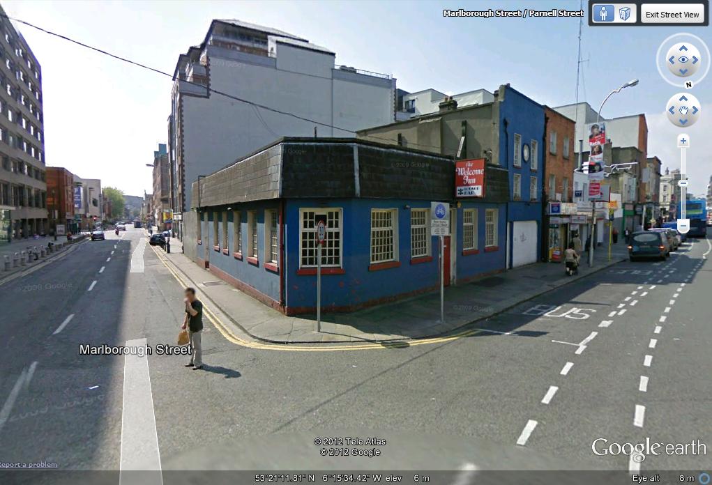
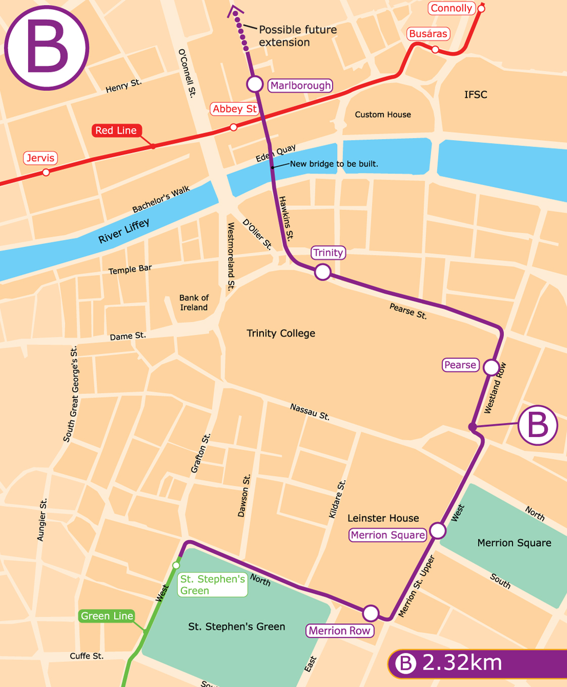
This issue and the issue of overhead wires in historical locations could be completely avoided if the LUAS was routed down Marlborough Street in both directions and around the back of Trinity, Route Option B:
http://www.rpa.ie/Maps/Luas%20Line%20BX/Luas%20City%20Centre%20Link%20Up%20Line%20BX%20Route%20Option%20B.map.jpg
I thought of that route too but didn't realise anyone else had considered it! Merrion Street would be the perfect size to accomadate Luas and regular traffic and you wouldn't need to put the Luas up the already mental Nassau Street/College Green.
That route gets my #1 anyway!
Cheers for the map.0 -
Can ABP direct the RPA to re-route both tracks for BXD via Marlborough st? on t he basis that the O'Connell street track would be too disruptive and cause an obsticle to Metro North's O'Connell st stop(which they have already approved)0
-
Surely though given this connects with the green line having the BXD bit "Wireless" just gonn add additional cost as all trams in usage on existing lines would need to be replaced/retrofitted if they were to provided service over BXD section?0
-
I'm not sure. While ABP can easily deny them part of the project or suggest minor amendments, double tracking Parnell Street to College Street is rather substantial. It may also have unintended knock-on effects on bus services on Talbot Street / Marlborough Street / Lower Abbey Street.Can ABP direct the RPA to re-route both tracks for BXD via Marlborough st? on t he basis that the O'Connell street track would be too disruptive and cause an obsticle to Metro North's O'Connell st stop(which they have already approved)
Only those trams operating on the relevant section would need to be changed. While Luas currently has a slight surplus in trams, they are going to have to start thinking about refurbishment / replacement in the next 5-7 years on top of any additional trams bought for BXD.Surely though given this connects with the green line having the BXD bit "Wireless" just gonn add additional cost as all trams in usage on existing lines would need to be replaced/retrofitted if they were to provided service over BXD section?0 -
Surely though given this connects with the green line having the BXD bit "Wireless" just gonn add additional cost as all trams in usage on existing lines would need to be replaced/retrofitted if they were to provided service over BXD section?
indeed, routing both tracks down marlborough st is way cheaper, bus services can be relocated if need be.0 -
Advertisement
-
routing NB services via Marlborough Street might be cheaper but the right hand turn to get onto Parnell Square is presumably a concern?
As for ABP, they relocated the depot of Metro North, hardly a "minor" adjustment.0 -
They should just consider re-routing MN to an alignment slightly west of O'Connell Street.0
-
Do you mean the left turn from Marlborough Street to Parnell Street? If necessary, interlaced tracks could be an option.routing NB services via Marlborough Street might be cheaper but the right hand turn to get onto Parnell Square is presumably a concern?
No, they refused permission for it and told them to apply for another railway order.As for ABP, they relocated the depot of Metro North, hardly a "minor" adjustment.0 -
Can ABP direct the RPA to re-route both tracks for BXD via Marlborough st? on t he basis that the O'Connell street track would be too disruptive and cause an obsticle to Metro North's O'Connell st stop(which they have already approved)
The process they used for Metro North was to grant permission bar the permission for the depot with the condition that no works beyond enabling works were completed before getting permission for a new depot location. Line routing might be more sensitive, so they could just say no works whatsoever until it is completed.
The other, and maybe simpler option they seem to be using is just to wait for new details requested and if the options are acceptable to ABP, then wait for new consultation and an amended submission and evaluate those....double tracking Parnell Street to College Street is rather substantial. It may also have unintended knock-on effects on bus services on Talbot Street / Marlborough Street / Lower Abbey Street.
Substantial maybe, but on balance double tracking Marlborough seems to be a better option:- Removes conflicts with station boxes other than at the Green
- And the need for business on these streets to have major construction at their doors twice
- Removes the issue of the O'Connell Street medium
- Reduces the chances events on O'Connell Street will affect Luas services
- At least somewhat lessens the case for wireless running
- Removes conflicts with bus routes on O'Connell Street
- Removes the need to dig up half of O'Connell Street again
- Makes the route more simple for occasional users, out of town shoppers and tourists
- Makes the junction at the top of O'Connell Street simpler compared to the current plan of making the junction crazier
- Lowers the amount of tram turns and junctions cyclists would have to interact with
Routing to the back of Trinity, Route Option B, would increase the amount of positives in some cases (conflict with buses, masses of pedestrians and cyclist; avoiding the more historically important College Green; etc) but they would also have to contend with a slightly longer route and a greater affect on general traffic.routing NB services via Marlborough Street might be cheaper but the right hand turn to get onto Parnell Square is presumably a concern?
If you mean the corner of Marlborough Street / Parnell Street corner, it might require the CPOing of the corner building(s). For maybe largely good reasons, RPA seem to go to great lengths to avoid land take, but it should not be a show stopper in this case.0 -
Moderators, Motoring & Transport Moderators, Technology & Internet Moderators Posts: 22,665 Mod ✭✭✭✭
 Join Date:Posts: 22261
routing NB services via Marlborough Street might be cheaper but the right hand turn to get onto Parnell Square is presumably a concern?
Not much of a concern, even if you did need to CPO the building on the corner of Marlborough and Parnell Street, it is a very old and crappy single story building containing a very cheap Chinese restaurant.
I'm sure the cost savings of not having two separate tracks would more then easily cover the CPO costs.0 -
Advertisement
-
If you mean the corner of Marlborough Street / Parnell Street corner, it might require the CPOing of the corner building(s). For maybe largely good reasons, RPA seem to go to great lengths to avoid land take, but it should not be a show stopper in this case.
+1
Marlborough Street corner.jpg
Using option B would be much better in my humble opinion. On top of the advantages you already mentioned, it would put a stop at Pearse street station.
Luas City Centre Link Up Line BX Route Option B.map.jpg
However, the increased time would take to cross the city is a big issue, not to mention the fact that it would take from the arguement of pedestrianising college green.0 -
. Double-decker neon yellow busses are worse. Naked poles and duplicative streetlamps are worse.
As a general rule I hate overhead wires, they are the mark of the visually illiterate.")
But tram wires don't bother me - however to say yellow buses are worse is going too far.
I love those yellow buses. 0
0 -
Westland Row simply cannot have two luas tracks going down it, there is no other route for this traffic to go and also a still-significant number of bus routes use it. Considerably more since the Lucan QBC services' terminus was moved to Merrion Square. As it stands, there's heavy traffic congestion on Sandwith street upper at peak times.0
-
-
To_be_confirmed wrote: »Westland Row simply cannot have two luas tracks going down it, there is no other route for this traffic to go and also a still-significant number of bus routes use it. Considerably more since the Lucan QBC services' terminus was moved to Merrion Square. As it stands, there's heavy traffic congestion on Sandwith street upper at peak times.
Phrases like 'simply cannot', 'imposable', 'it won't work', 'we need the space for traffic' were all use for Grafton Street, bus lanes when they started, more lately the bus gate and, very relevant here, the original Luas lines in the city centre! The space was taken from cars, but the world has yet end.
What traffic movements are you so concerned about? Traffic going from where to where?
Buses and trams can share road space.0 -
-
-
To_be_confirmed wrote: »Westland Row simply cannot have two luas tracks going down it, there is no other route for this traffic to go and also a still-significant number of bus routes use it. Considerably more since the Lucan QBC services' terminus was moved to Merrion Square. As it stands, there's heavy traffic congestion on Sandwith street upper at peak times.
Bit of an exaggeration. Would be difficult in current traffic (and one way) configuration in the area but streets can be reversed. Upper Erne Street could be made one way. Traffic is already one way in the other direction on Upper Sandwith Street.
Big improvement could be made if Quays were redone in one direction on City Quay, Sir John Rogerson's, North Wall and Custom House. Would require Samuel Becket Bridge no right turns to be changed. Realistically, would require new bridge from Britain Street to East Link.
But there are solutions.0 -
That's just not a fair comparison, literally less than 200 metres away from Grafton St. is a very wide thoroughfare aka Dawson St. And then Kildare St. is not much further off. I'd appreciate if you didn't compare apples and oranges.Phrases like 'simply cannot', 'imposable', 'it won't work', 'we need the space for traffic' were all use for Grafton Street, bus lanes when they started, more lately the bus gate and, very relevant here, the original Luas lines in the city centre! The space was taken from cars, but the world has yet end.
What traffic movements are you so concerned about? Traffic going from where to where?
Buses and trams can share road space.
I ask you to look on a map at what roads are there in the area and see for yourself the daily levels of traffic on Westland Row, Sandwith St. and Macken St. I have to go to or cross Westland Row several times daily as I live not that far away. Be it to go to college, for shopping, my nearest Dart station or even popping into newsagents. I don't exactly flag down traffic and ask them where they're from or going to. Unlike Dame st and the Bus Gate, the consistent majority of vehicles are privately-owned. Worse, Westland row is busy throughout the day and not just as a peak time rat run. Going on my own experiences of driving around Dublin, I'd say the traffic is generally going to or from the south/east inner city and perhaps beyond but would wish to go to the northside for some reason. Either they can go Westland Row-Pearse St.-Tara St.-Butt Bridge or they can hope for light traffic on Macken St and the Beckett Bridge or they can pay the €1.75 toll by which time they've driven significantly out of their way if they e.g. were driving back from the eye and ear hospital on Adelaide Road.0 -
That's a fairly substantial detour down a smallish and almost entirely residential street, with a much lower overhead clearance than Pearse St. too. Actually I just checked, double-decker buses wouldn't even be able to pass underneath... I guess that could be ameliorated by making Westland Row a bus lane post-luas. I don't think that solution will be so useful for trucks. SJR quay would then be unable to be made one-way as otherwise the maximum height of vehicles able to access that section of the city delineated by the Dart line would be reduced to whatever Macken St could handle. Which is 4.38m I think and only by driving in the middle of the road. Or I suppose higher trucks could go by Landsdowne Road or roads further south.Bit of an exaggeration. Would be difficult in current traffic (and one way) configuration in the area but streets can be reversed. Upper Erne Street could be made one way. Traffic is already one way in the other direction on Upper Sandwith Street.
Big improvement could be made if Quays were redone in one direction on City Quay, Sir John Rogerson's, North Wall and Custom House. Would require Samuel Becket Bridge no right turns to be changed. Realistically, would require new bridge from Britain Street to East Link.
But there are solutions.
There are solutions in some form or another to all of the above but why in all honesty would people go to such effort just to avoid bringing luas tracks through College Green?? In my mind the best solution is not to have LUAS between St. Steph's green and Abbey St. but what's done is done.0 -
Advertisement
-
You're missing my point. You said it was imposable and they said it was imposable, both of you are wrong.
There's more than enough room on the Westland Row for bus/tram in both directions, and at least one traffic lane in one direction. Changes show that traffic adapts and can adapt, and should also be reduced with people switching to a more useful cross-city Luas service.To_be_confirmed wrote: »That's just not a fair comparison, literally less than 200 metres away from Grafton St. is a very wide thoroughfare aka Dawson St. And then Kildare St. is not much further off. I'd appreciate if you didn't compare apples and oranges.
Dawson St isn't that wide and it bottlenecks on its north end into just two lanes -- one a 24 hour bus lane and one is shared between heavy bus/coach traffic and private traffic.
The only peak legal traffic allowed on Kildare St comes from those from car parks or those doing a circle around Dawson St -- Kildare Street is not a major north-south route.
The routes on the west side of Grafton St were also very busy.To_be_confirmed wrote: »I ask you to look on a map at what roads are there in the area and see for yourself the daily levels of traffic on Westland Row, Sandwith St. and Macken St. I have to go to or cross Westland Row several times daily as I live not that far away. Be it to go to college, for shopping, my nearest Dart station or even popping into newsagents. I don't exactly flag down traffic and ask them where they're from or going to.
There was massive daily traffic levels on O'Connell Street, Grafton Street, Harcourt Street etc before they were changed. And streets around them and the nearest main north-south routes.
All of these streets, however, were also presumed by many to be so important that it could not be affected in any way.To_be_confirmed wrote: »Unlike Dame st and the Bus Gate, the consistent majority of vehicles are privately-owned. Worse, Westland row is busy throughout the day and not just as a peak time rat run.
The traffic off-peak can handle it self and use the nearby routes.
If trams go down the road, the trams would make far better use of the space and carry far more people than the cars currently do.To_be_confirmed wrote: »Going on my own experiences of driving around Dublin, I'd say the traffic is generally going to or from the south/east inner city and perhaps beyond but would wish to go to the northside for some reason. Either they can go Westland Row-Pearse St.-Tara St.-Butt Bridge or they can hope for light traffic on Macken St and the Beckett Bridge or they can pay the €1.75 toll by which time they've driven significantly out of their way if they e.g. were driving back from the eye and ear hospital on Adelaide Road.
Traffic going north-south outside of the canals can divert. There's no way through-traffic using a city centre as a route should get space over buses or a tram line carrying large amounts of people.
Traffic from residents going north-south inside the canals is a small amount of the overall trips (for example, only 22% within the canal use a private transport for commuting) and only a tiny amount of them would be using this route. They'll manage just fine off.
For traffic going from one point within the canals to another within the canals, they'll manage just fine off peak, but there is no way trips of between 1-4km by car should be encouraged and planned for over high-capacity public transport.0 -
To_be_confirmed wrote: »Going on my own experiences of driving around Dublin, I'd say the traffic is generally going to or from the south/east inner city and perhaps beyond but would wish to go to the northside for some reason. Either they can go Westland Row-Pearse St.-Tara St.-Butt Bridge or they can hope for light traffic on Macken St and the Beckett Bridge or they can pay the €1.75 toll by which time they've driven significantly out of their way if they e.g. were driving back from the eye and ear hospital on Adelaide Road.
...Or they could catch Luas BXD :pac:0 -
Would you mind addressing my points rather than having your own little conversation?! You're neglecting the substantial impact on commercial vehicles this would have if you only talk about "cars". Also, where did I merely refer to the residents within the canal area?? Plenty of people would eventually travel by Westland Row even if they were travelling from well beyond the canals. Whether they are residents of within the canal cordon isn't particularly relevant.You're missing my point. You said it was imposable and they said it was imposable, both of you are wrong.
There's more than enough room on the Westland Row for bus/tram in both directions, and at least one traffic lane in one direction. Changes show that traffic adapts and can adapt, and should also be reduced with people switching to a more useful cross-city Luas service.
Dawson St isn't that wide and it bottlenecks on its north end into just two lanes -- one a 24 hour bus lane and one is shared between heavy bus/coach traffic and private traffic.
The only peak legal traffic allowed on Kildare St comes from those from car parks or those doing a circle around Dawson St -- Kildare Street is not a major north-south route.
The routes on the west side of Grafton St were also very busy.
There was massive daily traffic levels on O'Connell Street, Grafton Street, Harcourt Street etc before they were changed. And streets around them and the nearest main north-south routes.
All of these streets, however, were also presumed by many to be so important that it could not be affected in any way.
The traffic off-peak can handle it self and use the nearby routes.
If trams go down the road, the trams would make far better use of the space and carry far more people than the cars currently do.
Traffic going north-south outside of the canals can divert. There's no way through-traffic using a city centre as a route should get space over buses or a tram line carrying large amounts of people.
Traffic from residents going north-south inside the canals is a small amount of the overall trips (for example, only 22% within the canal use a private transport for commuting) and only a tiny amount of them would be using this route. They'll manage just fine off.
For traffic going from one point within the canals to another within the canals, they'll manage just fine off peak, but there is no way trips of between 1-4km by car should be encouraged and planned for over high-capacity public transport.
As for talking about Dawson St and Kildare St, the current traffic restrictions and one-way systems are of no relevance as such. I was merely saying that they were two alternative (and parallel) streets to the pedestrianised Grafton Street. The impact on traffic would have been pretty much minor. In comparison, I am still waiting to see how the heavy existing traffic volumes are to be mitigated considering they can't just be sent the far side of Trinity. And the only alternative seems to be to reroute it all through residential areas off Pearse St. The worst part of this idea is that the LUAS track as proposed would replace or agument practically none of the public or private transport that would be travelling from the southeast of Dublin city or from the docklands/IFSC. It's questionable if the Luas would utilise the road as much as the constant volume of private traffic. In the case of double-decker buses, definitely not. I wouldn't mind if westland row was made into a public transport/bike route but to give tram transport priority over buses filled with commuters, so people don't have to walk the 15 minutes is ludicrous.
How long would it take to travel via luas the whole way around TCD? I also question whether anything more than two LUAS tracks can be brought down Westland Row. It's narrower than Abbey street for example.0 -
-
To_be_confirmed wrote: »Grand if they live in Phibsboro... But this is the whole point, Westland row is more important for traffic going to northeastern or southeastern parts of the city. Places served by DART or Dublin Bus.
But for these journeys there are routes that bypass the city centre. Private traffic in the city centre should only really consist of city centre bound traffic anyway.0 -
What routes bypass the city centre for the type of traffic I referred to?? The only free one I can think of is Macken St/Cardiff Lane, Beckett Bridge and then Sheriff St. It's already jammed every day at peak time.But for these journeys there are routes that bypass the city centre. Private traffic in the city centre should only really consist of city centre bound traffic anyway.0 -
To_be_confirmed wrote: »What routes bypass the city centre for the type of traffic I referred to?? The only free one I can think of is Macken St/Cardiff Lane, Beckett Bridge and then Sheriff St. It's already jammed every day at peak time.
There are the routes you mentioned, there is also Church Street. And of course, all the originating points and destination points between north and south city that you mention also fall within the catchment area of the Dart.0 -
I've already referred to this; you can't make a delivery to a shop or pub by dart for example.0
-
Again: There's loads of room on Westland Row for a combined Luas and bus lane and at least one lane of car traffic in one direction.To_be_confirmed wrote: »You're neglecting the substantial impact on commercial vehicles this would have if you only talk about "cars".
The best thing for commercial transport is to focus on reducing the amount of cars within the canals and elsewhere. You want to do the complete opposite and prioritise congestion.To_be_confirmed wrote: »Also, where did I merely refer to the residents within the canal area?? Plenty of people would eventually travel by Westland Row even if they were travelling from well beyond the canals. Whether they are residents of within the canal cordon isn't particularly relevant.
I did not say you referred to them.
They should divert around the city centre if they are not starting their trip within or near the canals. Where users of Westland Row are residents of is very much so relevant to traffic management.To_be_confirmed wrote: »As for talking about Dawson St and Kildare St, the current traffic restrictions and one-way systems are of no relevance as such. I was merely saying that they were two alternative (and parallel) streets to the pedestrianised Grafton Street. The impact on traffic would have been pretty much minor. In comparison, I am still waiting to see how the heavy existing traffic volumes are to be mitigated considering they can't just be sent the far side of Trinity. And the only alternative seems to be to reroute it all through residential areas off Pearse St. The worst part of this idea is that the LUAS track as proposed would replace or agument practically none of the public or private transport that would be travelling from the southeast of Dublin city or from the docklands/IFSC.
The problem is that you're making the exact same kind of claim that those who wanted cars to remain on Grafton Street made. And they made exactly the same points about traffic having nowhere to go and the nearby streets no being able to handle the extra traffic.
No matter how you dress it up, your main points are the same as those who wanted to keep cars on Grafton Street, and in this case we're not even talking about fully removing cars!To_be_confirmed wrote: »It's questionable if the Luas would utilise the road as much as the constant volume of private traffic.
Luas peak boards ranges from full to crushed and it has a very high usage rate off peak. The average private car peak boarding equals 1.2 persons (DCC canal count 2011). Even the norm for the half decent Dublin Bus routes is full to nearly full buses at peak times.
Luas keeps moving expect the odd time when motorists block junctions, but cars at rush hour are the congestion.To_be_confirmed wrote: »In the case of double-decker buses, definitely not. I wouldn't mind if westland row was made into a public transport/bike route but to give tram transport priority over buses filled with commuters, so people don't have to walk the 15 minutes is ludicrous.
What are you talking about? I've already said in my last post: "There's more than enough room on the Westland Row for bus/tram in both directions, and at least one traffic lane in one direction" and Luas BXD is goes further north than a 15min walk. Or do you know many who can walk from the Green to just south of Finglas in 15mins?To_be_confirmed wrote: »How long would it take to travel via luas the whole way around TCD? I also question whether anything more than two LUAS tracks can be brought down Westland Row. It's narrower than Abbey street for example.
No, it's not narrower than Abbey Street as a whole. Maybe a small part of Abbey Street, but not overall.
Outside the train station should have the space of a Luas stop with one or more wide platforms, extra space for buses to make it by the platform/s and one traffic lane. The space there is all at least 20m+ for more than the length of a platform.
And agreed the biggest issue is how fast it could get around TCD -- it is around 700m extra compared to the College Green route, but there's no major junctions where traffic would cross the line (only traffic into TCD at one large gate), and routing around the potential speed and safety conflicts with pedestrians and cyclists would be slashed.0 -
Advertisement
-
I think the problem is that you are point-blank refusing to look at all the facts of this. Clearly there are differences in the local environment of Westland Row and Pearse St. compared to Grafton St. and Dame St. Again you are comparing apples and oranges. I ask you again to look at a map and show me where existing traffic would go rather than wistfully talk about cars and particularly lorries and trucks not being used in city centres. After the luas is built, there would still be substantial traffic volumes in the area.monument wrote:The problem is that you're making the exact same kind of claim that those who wanted cars to remain on Grafton Street made. And they made exactly the same points about traffic having nowhere to go and the nearby streets no being able to handle the extra traffic.
No matter how you dress it up, your main points are the same as those who wanted to keep cars on Grafton Street, and in this case we're not even talking about fully removing cars!
It seems you want to put words in my mouth.monument wrote:The best thing for commercial transport is to focus on reducing the amount of cars within the canals and elsewhere. You want to do the complete opposite and prioritise congestion.
So what then of the times when pedestrians and cyclists would want to travel a route intersected by a LUAS route? I mean, it's not like motorists are the root of evil here.Luas keeps moving expect the odd time when motorists block junctions, but cars at rush hour are the congestion.
Ah here now, it was clear what I was talking about. I was talking about the 10 to 15 minute walk from St. Steph's green to Abbey St. Look at what I said:What are you talking about? I've already said in my last post: "There's more than enough room on the Westland Row for bus/tram in both directions, and at least one traffic lane in one direction" and Luas BXD is goes further north than a 15min walk. Or do you know many who can walk from the Green to just south of Finglas in 15mins?To_Be_Confirmed wrote:In the case of double-decker buses, definitely not. I wouldn't mind if westland row was made into a public transport/bike route but to give tram transport priority over buses filled with commuters, so people don't have to walk the 15 minutes is ludicrous.
I never discussed the merits of a LUAS to Broombridge, something I wouldn't question. I rather think it's of very questionable value to have a LUAS from Grafton St. to O'Connell St. I think a LUAS link via Westland Row is simply unacceptable however. O'Connell St. to Broombridge would be fine with me. I have previously said that some sort of bus priority route might work through Westland Row but the extra impact at having to dedicate one or two lanes to a LUAS would be very unwelcome. Going on what I see on James' St., a lot of congestion can happen just from traffic sharing a lane with the LUAS.0


Advertisement