Advertisement
If you have a new account but are having problems posting or verifying your account, please email us on hello@boards.ie for help. Thanks :)
Hello all! Please ensure that you are posting a new thread or question in the appropriate forum. The Feedback forum is overwhelmed with questions that are having to be moved elsewhere. If you need help to verify your account contact hello@boards.ie

Info (including) photos) on ancestors - Inishkeel area

Options
2»

Comments

  • Registered Users Posts: 692 ✭✭✭Durnish


    posting live from Portnoo area, stormy day.

    That info was in the Glenties and Inishkeel /Liam Briody book. It has a chapter about the COI clergy for the district.

    My friend and I had a great day yesterday, investigating the Churchtown site and going on to the Kilkenny site. Without our families with us we can go off exploring. Great bacon sarnies in the cafe at Naran strand. I shall upload the pics and the info when I am back home, on cheap braodband.


  • Registered Users Posts: 22 Victorian


    I had to look up what a bacon sarnie was. Sounds hearty, don't think I've heard of anyone eating a bacon sandwich before, but I'm sure it was great after exploring all day and I envy the view you had.
    I am going to order Lochlann McGill's book from Amazon. There is a used 1st edition 1992 for ~ $55 or a used revised edition 2001 for ~ $35. Which one would you recommend? Is the revised one lacking info or something, because it's $20 cheaper.
    Thank you in advance.


  • Registered Users Posts: 692 ✭✭✭Durnish


    I have the 2001 edition. The paper is different and there is a forward by the local author, Brian Friel (Dancing at Lughnasa, Translations). Apart from that I don't know of any other difference.


  • Registered Users Posts: 22 Victorian


    Durnish wrote: »
    I have the 2001 edition. The paper is different and there is a forward by the local author, Brian Friel (Dancing at Lughnasa, Translations). Apart from that I don't know of any other difference.

    Great. Thanks.


  • Registered Users Posts: 692 ✭✭✭Durnish


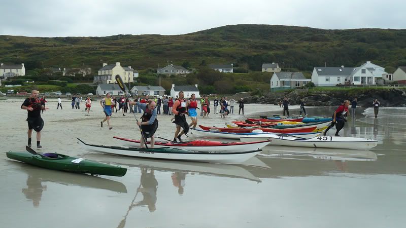
    Right, I know this looks like a sporting even but it also is the best view from Naran beach of the Churchtown site. The white old style cottage, behind canoeist in red lifejacket, is on the site of the church and the graveyard (or laying out field) is between it and the row of cottages on the cliff. I reckon that the wall is prob part of old site.
    More to come.

    gapnaran2.jpg


  • Advertisement
  • Registered Users Posts: 692 ✭✭✭Durnish


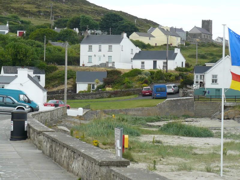
    This the view from the car park on Naran. The plain white cottage is now seen from the side, the area in front of it was where the church was, according to the kind local man who showed us. He was totally sure that no bodies had been buried in the "graveyard", seen as the green lawn with the beach wall to the right, they merely lay there waiting for the island graveyard to be accessible at low tide. The present church is seen, safely out of the way of the tide.

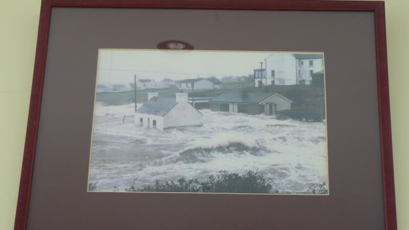
    A later, rather dramatic, picture may explain why the site was abandoned.
    Churchtown.jpg


  • Registered Users Posts: 692 ✭✭✭Durnish


    Here we go, Churchtown site in the winter of 87, I think. Totally washed through by the Atlantic. This pic was in the bacon sarnie cafe.

    Churchtownwaves1987.jpg


  • Registered Users Posts: 22 Victorian


    WOW. Those are fantastic photos. I can just imagine Rev. Walter in his glebe house along the shoreline. It must be horrifying when a brutal storm comes along like in 1987 but hopefully they're rare. You have also satisfied my curiosity about if he was buried there. The ordnance map said 'disused graveyard' and I had wondered if there were any graves still there.


  • Registered Users Posts: 692 ✭✭✭Durnish


    Back to Lettermacaward. I must say that the drive from Portnoo to Dooey strand is exceptionally beautiful.
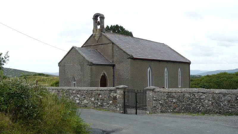
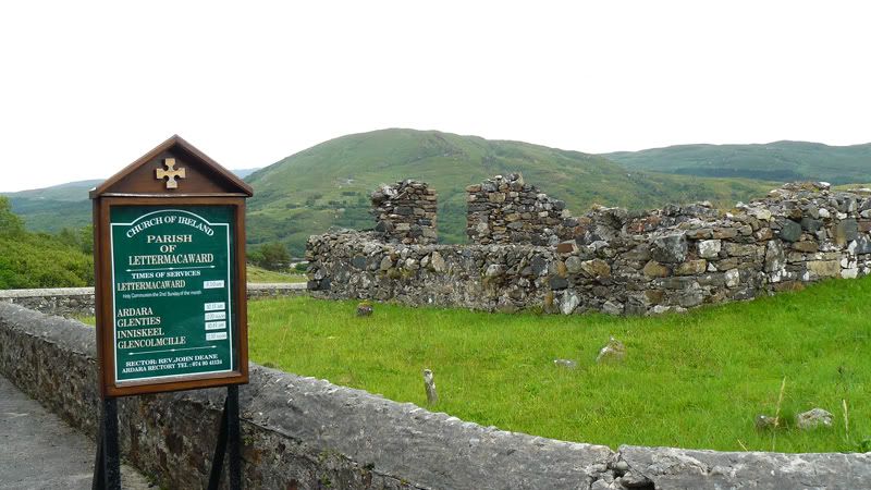
    If you take the left turn after Elliot's Tavern then you pass the tiny C of I Church, (1778) built beside an old pre-plantation church and graveyard annexed by the planters. LettermacCofI.jpg

    Inside the church outer wall the old church and graveyard are on the left. Some very old graves here, amazing to think that some of them would have been engraved by masons born around the time of the plantation and Cromwellian wars.

    Inside the enclosure,

    oldchurchandgraveyard.jpg


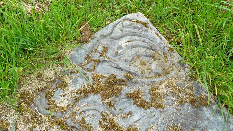
    This is a very interesting stone, with three leaping fish and a hammer clearly visible. Couldn't read the inscription.
    fishandhammer.jpg


  • Registered Users Posts: 692 ✭✭✭Durnish


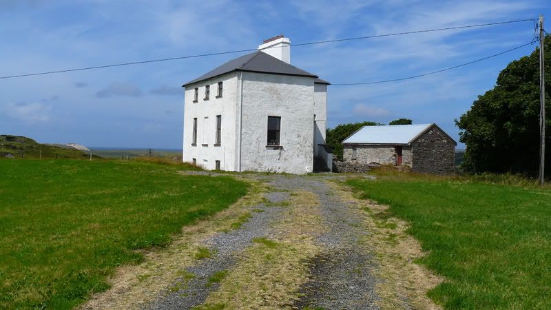
    Drive along about half a mile, on beautiful route, and there up on the right is the Glebe House, in a townland of its own, built plain and rectangular with a hidden basement, dummy windows, and a "return". Lovely little stable yard at the rear. Built with a grant from, wait for it, Board of First Fruits, in 1828.
    LettermacGlebe1.jpg


    I see from the old OS 25 inch that there must have been a garden at the back with fruit trees. A man along the road told us earlier that the present owner was trying to get a grant from the Heritage/Taisc people to restore the building sympathetically.


  • Advertisement
  • Registered Users Posts: 692 ✭✭✭Durnish


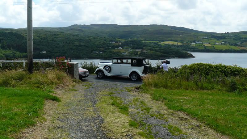
    As I was up noseying about the old Glebe House, a tradional Donegal wedding procession went past. I caught the bride's car going past the gate. Charming.

    Lettermacwedding.jpg

    Actually, this pic shows the old ferry crossing and the road leading down to it as well.

    It is a very interesting area, with a very shaky Plantation history. Some of the Planters (mainly in Loughros Point) couldn't afford to pay to upkeep an Established Anglican rector and so turned to Methodism, according to McGill's History of the Parish.


  • Registered Users Posts: 692 ✭✭✭Durnish


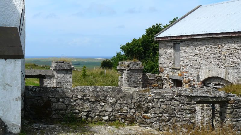
    Here is the sunken stable yard, with view of Dooey sandhills and the Na Rossa Gaelic pitch down in the callows (dark green),
    Glebeyard.jpg

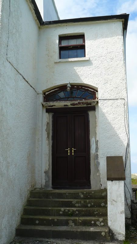
    This is the doorway, in the return, showing original fanlight and new double doors.
    Glebefanlight.jpg


  • Registered Users Posts: 22 Victorian


    I loved all the photos. The little church looks so quaint and must hold a very small congregation. I would not have recognized the fish on the gravestone with the hammer. I wonder what it represents. I can't believe how close you got to the glebe house. The owner must be very proud of this house to be taking such care restoring it. Good for him to keep the history alive. The views must be fabulous from up there.
    I received my copy of 'In Conall's Footsteps' a week ago and am thoroughly enjoying it. The history of the area that you have supplied me with makes it all come together. I did get confused with the chapter on St. Conall tho. The lineage of the saints is overwhelming to me. Do you learn about them all in school?
    Thank you so much for the trouble you have gone to to procure such interesting photos for me.


  • Registered Users Posts: 692 ✭✭✭Durnish


    Gosh, I don't understand all that St Conall stuff, it's the little snippets of local history and geography that astonish me. The author's style is very wordy. His father's version, the History of the Parish of Ardara, (Probably long out of print) is more direct about the Plantation and the land/tithe wars. You do understand about the tithes the whole population, regardless of religion, had to pay to the Established Church, C of I?

    There was no one home in the Glebe house, otherwise I would have asked, eventually and politely, for a wee look inside. It must be one room thick, front to back, apart from the return.
    I am glad you like the pics, my friends and I, mostly long lapsed Anglicans, are fascinated by this stuff. I did learn about landwars and tithes and so on, at school but my school was an exception in NI, a state school providing Irish History to A level in the 70's.


  • Registered Users Posts: 22 Victorian


    I wasn't actually aware that tithes were paid to the C of I by all denominations. I read an account whereby one fellow could not pay his tithe because he was destitute. As he didn't even own furniture that could be taken in lieu of his tithe, he was jailed. Harsh.
    I am gaining knowledge of Irish history as I go along. A few years back, all I knew about was the planters, the famine, U2 and St. Patrick.
    Speaking of tithes, when Rev. Thomas (Lettermac) was in Templecrone, his eldest son collected his father's tithes and was never seen in Ireland again. He bought himself a commission in the India Army. I always wondered how his parents and siblings managed that year.


  • Registered Users Posts: 692 ✭✭✭Durnish


    oh aye, that's why the Anglican church was dis-established. I do rem that from "O" level history. It must have been a strange and isolated life for any Anglican rector and family who took up those western seaboard parishes two or three centuries ago.


  • Registered Users Posts: 22 Victorian


    It was probably the lesser of 2 evils in our case. Family lore says Walter had to leave Scotland because he was implicated in the uprising of the Royal Stewarts. Exile or death.


  • Registered Users Posts: 692 ✭✭✭Durnish


    Oh, I thought maybe it was all something to do with the Stewarts of Horn Head House. Is that the Jacobite rebellion you are writing about, like BPC and all?


  • Registered Users Posts: 22 Victorian


    Yes, the Jacobite uprisings. Our family bible says that he left the Isle of Bute ~ 1745 and was given the living of Inniskeel by his cousin, John, the 3rd Earl of Bute. I already have contradictory evidence to much of this statement i.e. he was in Donegal in the 1730s; Inniskeel was not his first living; I can't find that the Earl of Bute was patron of any living in Donegal altho maybe he just pulled a few strings; the word 'cousin' is being stretched here and means distant relative. Walter was born ~1704 so would be too young for the 1st uprising. C'est la vie.


  • Registered Users Posts: 812 ✭✭✭rightyabe


    Durnish wrote: »
    This the view from the car park on Naran. The plain white cottage is now seen from the side, the area in front of it was where the church was, according to the kind local man who showed us. He was totally sure that no bodies had been buried in the "graveyard", seen as the green lawn with the beach wall to the right, they merely lay there waiting for the island graveyard to be accessible at low tide. The present church is seen, safely out of the way of the tide.

    A later, rather dramatic, picture may explain why the site was abandoned.
    Churchtown.jpg


    Sorry just new to board.ie today.

    I'm only 22, and live in portnoo/narin area. I remember at a wake years ago people talking about the old graveyard on the strand road.

    The story goes that in the winter time when the seas were rough the dead were buried there, because the island was inaccessable. But i all stopped years ago(dont know a approx year) due to the old wall being washed away which let the sea erode the graves. they built a concrete wall there soon after.


  • Advertisement
  • Registered Users Posts: 22 Victorian


    That's helpful. Thanks for the update.


  • Closed Accounts Posts: 8 alfieeasterby


    Hi there, my family have a house on Duck street for the last 30 years. if you have a facebook account, you might be interested in this page which we made.

    https://www.facebook.com/group.php?gid=116414028395167

    also my email address is <SNIP> if you would like to mail me and I can send you any information/photos I have.

    Best wishes

    B


    Mod edit: We dont allow personal email addresses to be posted (more for your own benefit) but if anyone wants it perhaps they could use the PM facility. Thanks.


  • Registered Users Posts: 78 ✭✭redbeaard


    <SNIP>

    Mod note: Behave. This is a discussion forum and not a billboard for property sales.


Advertisement