Advertisement
If you have a new account but are having problems posting or verifying your account, please email us on hello@boards.ie for help. Thanks :)
Hello all! Please ensure that you are posting a new thread or question in the appropriate forum. The Feedback forum is overwhelmed with questions that are having to be moved elsewhere. If you need help to verify your account contact hello@boards.ie

The Crayon Map Thread

Options
2»

Comments

  • Registered Users Posts: 13,872 ✭✭✭✭Zebra3


    sdonn wrote: »
    Do you mean that these trains would call at Heuston after leaving Connolly, or now terminate at Heuston instead? In either case, they can't get to Sligo or Mullingar without using the maynooth line, how can that be avoided??

    The poster is proposing building a link (marked red) from between Maynooth and Leixlip to join up with the line to Heuston on the cityside of Celbridge. Is the length of this link 6km? My rough guess. :)

    This means ICs from Sligo (and Longford commuter services?) can use the quad tracked line to Heuston freeing up Maynooth-Connolly for Maynooth/M3/Navan services.

    Great idea imo. :)


  • Registered Users Posts: 68,545 ✭✭✭✭L1011


    Are the "high speed" lines on the KRP the middle or outer ones? Building a grade seperated rail junction to get trains on to the middle tracks would be horrendously disruptive; to the outer ones not so much so. Building a flat junction would block paths and be counter productive.


  • Registered Users Posts: 4,316 ✭✭✭KC61


    Fast tracks on Kildare route are the outer lines.

    A grade separated junction will have to be built at Inchicore ultimately.


  • Registered Users Posts: 1,419 ✭✭✭Cool Mo D


    KC61 wrote: »
    Fast tracks on Kildare route are the outer lines.

    A grade separated junction will have to be built at Inchicore ultimately.

    You can see Irish Rail's design for the grade-seperated junction here


  • Registered Users Posts: 4,905 ✭✭✭Aard


    attachment.php?attachmentid=132659&stc=1&d=1288211971


    To the north and south-east the metro follows Metro North and Luas B1 respectively. To the south-west the metro goes to Saggart, sharing the Luas line briefly. To the north-west the metro doesn't follow Metro West's alignment, rather it would go to Blanchardstown Shopping Centre. The Luas Green line runs from Connolly to Beechwood. The metro will go underground just before Beechwood to interchange with the Luas.


  • Advertisement
  • Registered Users Posts: 1,068 ✭✭✭xper


    Ah what the hell, I was bored, here's my Metro South ...

    133127.jpg

    The 'loops' are options, not forked lines. I think the UCD option might be stretching things. Could also swing west from St Stephen's Green to hook up at Kimmage but the curve takes you almost out to the canal so you are talking one or two statons max (Portabello/Harold's Cross?)

    Tunnel as far out as Rathfarnham, albeit coming above ground at UCD and Milltown on that option, another tunnel between Templeogue and Firhouse.

    Several options approaching Tallaght. Southernmost probably gives best spread but not sure if the turns are viable.


  • Registered Users Posts: 888 ✭✭✭Telchak


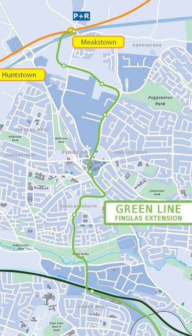
    Had a go myself at a future BXD extension all the way to Metro West ;)

    FinglasLuasRoute.jpg

    I have also drawn detailed plans on a redevelopment and redesign of Finglas Village so Luas can run through it :P


  • Registered Users Posts: 4,905 ✭✭✭Aard


    Whoever ruined that greenway through Finglas should be shot. It would have been perfect for servicing West Finglas, which (according to Deloitte, iirc) is very poorly served by bus atm, as well as being relatively high density. :(


  • Registered Users Posts: 888 ✭✭✭Telchak


    Aard wrote: »
    West Finglas, which (according to Deloitte, iirc) is very poorly served by bus atm, as well as being relatively high density. :(

    The 40s cover Finglas West well and are quite frequent. In fact, the 40 and 40A are being consolidated into one route under Network Direct that will likely result in a reduction of service :confused: Besides, I don't think you want the Luas going through an area that has a dump on one side, and a landfill on the other :P (I say this as somebody who spends a significant amount of time there ;))


  • Registered Users Posts: 37 coolmangg


    I have altered the Interconnector slightly.
    In my proposal the interconnector runs as a Dublin Inner City Orbital route (Blue Line). It joins up with the Phoenix Park Tunnel. Trains will run in both directions continuously around the city center. There will be interchanges with all other type of service, luas, Metro, heavy rail etc.

    In my proposal also, Sligo / Maynooth / Dunboyne trains will terminate in the Docklands, where they could interchange with the Orbital route. This will free up Conolly services allowing additional Darts to run. There will be an interchange at Ossary Rd between Sligo line and North Line trains also.

    The great thing about this option is that most of the rail is existing. Some new stations would need to be built. The Interconnector would be altered and not run as far as Inshicore, however trains would run from Hazzlehatch to Heuston, interchanging with the Orbital route here.

    I have also shown where I think the Metro West should extend to meet the northern train line.

    I have notionally included the metro south / metro west / Lucan Luas / etc however these are secondary to the concept of the Orbital route. This could be built quickly as half of the route is there today, and it will not interfere with existing lines and will connect the entire system, not only Conolly & Heuston.

    http://maps.google.com/maps/ms?ie=UTF8&hl=en&msa=0&msid=203718849652007389080.00049b7409e80af9d8802&ll=53.348297,-6.28624&spn=0.098169,0.209255&z=13

    Please let me know what you think


  • Advertisement
  • Registered Users Posts: 37 coolmangg


    Sorry.
    1 more point on this option.
    It will encourage a higher density city center, and rejuvenate run down areas
    of the city.
    We need to encourage a higher density city center. Commuting from Hazlehatch / Dunboyne, Balbriggan etc should not be encouraged. The Orbital route allows this.


  • Registered Users Posts: 1,313 ✭✭✭pigtown


    I have done a bit of crayoning and attached is my fantasy rail network for Limerick in the year 2040.
    It includes 5 heavy rail lines that I would envisage running hourly at peak and every two hours off peak, apart from the Ennis line which would run hourly throughout the day.

    A more concise suburban network would run every 15 minutes on the lines between Patrickswell, Annacotty Industrial Estate and Cratloe. To eliminate the need to reverse out of Colbert Station, a new station would be constructed on the existing bus maintenance yard.

    Two tram lines would run every 15 minutes North-South and East-West through the city, with the East-West line connecting up both Colbert Station and the new station. The North-South line terminates at an interchange with heavy rail at Father Russell Road but I wonder would it make sense* to continue the tram line through a tunnel as far as the regional hospital as it is the only way I can think of to link the hospital up with the network.

    I haven't included stops because a) there are too many and b) they clutter up the map.

    So, what say you?

    Also, would like to include pictures in post but it's not working. Any tips would be appreciated.

    * obviously it wouldn't make sense to build most of this proposal now but a tunnel is a significant undertaking


  • Registered Users Posts: 4,905 ✭✭✭Aard


    Link doesn't work. To attach an image, click on the reply button, then click on "manage attachments" on the reply page.


  • Registered Users Posts: 1,313 ✭✭✭pigtown


    Thanks Aard. Are the attachments working now?


  • Closed Accounts Posts: 292 ✭✭teol


    170845.jpg

    Luas Red Line
    Luas BXD
    Dart Underground
    Cross City - BRT

    I think my routing of the Luas BXD would be good. It would take in both St Patrick and Christchurch Cathedral, Dublin Castle, Grafton Street, Temple Bar, DIT-Grangegorman and Smithfield. The trams could travel direct from Broadstone Junction right to the O2 arena, taking in O'Connoll Street.


  • Registered Users Posts: 369 ✭✭weehamster


    Sorry, but as part of a feasibility study into line E (Broadstone to Dundrum) the section from Christchurch to Broadstone was deem not feasible. So I'm afraid your idea won't work. :o


  • Closed Accounts Posts: 292 ✭✭teol


    weehamster wrote: »
    Sorry, but as part of a feasibility study into line E (Broadstone to Dundrum) the section from Christchurch to Broadstone was deem not feasible. So I'm afraid your idea won't work. :o

    Bah! The problem is the O'Donavan Rossa Bridge across the Liffey. The reasons given for the infeasibilty are:

    X Protected structure requiring strengthening
    X Sub standard vertical curvature on bridge
    X Very steep southern approach gradients
    X Limited approaches would require road closure or single track

    http://www.transport21.ie/Projects/upload/File/Rathfarnham%20Feasibilty%20Study.pdf

    TBH I think all of these problems can be mitigated with a bit of effort and thought.


  • Registered Users Posts: 225 ✭✭ManAboutCouch


    This map I made of Population Change from 2006-2011 might be useful for people who have their crayons out:

    http://www.gamma.ie/CSO/Population2006-2011.html

    The 2011 figures are preliminary, but they're usually pretty accurate, based on numbers released in 2006 and 2002.


  • Closed Accounts Posts: 292 ✭✭teol


    teol wrote: »
    Bah! The problem is the O'Donavan Rossa Bridge across the Liffey. The reasons given for the infeasibilty are:

    X Protected structure requiring strengthening
    X Sub standard vertical curvature on bridge
    X Very steep southern approach gradients
    X Limited approaches would require road closure or single track

    http://www.transport21.ie/Projects/upload/File/Rathfarnham%20Feasibilty%20Study.pdf

    TBH I think all of these problems can be mitigated with a bit of effort and thought.

    Here is an alternative. Basically the same route, but going the other side of the Civic Offices and crossing the liffey on a new bridge. There would be some encroachment on minor warehousing units but the route pretty much stays away from main traffic arteries.

    http://maps.google.com/maps/ms?msa=0&msid=200832783753934675596.0004abcbddf5867559269


Advertisement