Advertisement
If you have a new account but are having problems posting or verifying your account, please email us on hello@boards.ie for help. Thanks :)
Hello all! Please ensure that you are posting a new thread or question in the appropriate forum. The Feedback forum is overwhelmed with questions that are having to be moved elsewhere. If you need help to verify your account contact hello@boards.ie
Hi there,
There is an issue with role permissions that is being worked on at the moment.
If you are having trouble with access or permissions on regional forums please post here to get access: https://www.boards.ie/discussion/2058365403/you-do-not-have-permission-for-that#latest

N14 - Letterkenny to Lifford [preferred route published; design underway]

  • 25-11-2010 8:27pm
    #1
    Closed Accounts Posts: 6,093 ✭✭✭


    This was mentioned in the Department of Transport's press release yesterday as possibly going ahead after 2011. I've not heard much about this scheme and I can find no maps of the proposed route.

    But! It will be:
    • 19 km long
    • Type 2 Dual Carriageway
    This route commences at the N13/N14 junction at Manorcunningham and continues to a junction with the N15 South West of Lifford. A separate project (N14/N15 to A5 Link) is being developed to link this scheme to the new A5 Western Transport Corridor being developed in Northern Ireland.
    http://www.donegalcoco.ie/services/roadstransport/majorprojects/manorcunninghamstrabane.htm


«1

Comments

  • Registered Users, Registered Users 2 Posts: 7,476 ✭✭✭ardmacha


    They should run the new Derry route on the right bank of the Foyle and have a shorter link to Letterkenny. This would also provide a new Derry Letterkenny link and better justify the 26 county contribution to the project.


  • Registered Users, Registered Users 2 Posts: 230 ✭✭johnbk


    I made a lot of effort early in the a5 project to get them to consider a west of Foyle option. They wouldn't even consider it. You are correct as this would have replaced the need for a new N14.

    Letterkenny has approx 17,000 people. Derry city including the towns within 20 miles of it has a population of approx 237,000. The aadt at Lifford bridge is 17570. The a5 at Omagh has an aadt of 19260. These are inadequate roads that need upgrading.

    If you consider the aadt at the a5 border of Monaghan is only 8430 then I would say the scope for increasing trade between Dublin and the north west is huge.

    Also, this investment is a very important
    part of the Good Friday peace agreement and I think the risk of cancelling the investment now is too large a risk for who ever is in government.

    My views are my own.


  • Registered Users, Registered Users 2 Posts: 770 ✭✭✭Jayuu


  • Registered Users, Registered Users 2 Posts: 5,385 ✭✭✭Redsoxfan


    johnbk wrote: »
    I made a lot of effort early in the a5 project to get them to consider a west of Foyle option. They wouldn't even consider it. You are correct as this would have replaced the need for a new N14.

    Any map of your proposed route?


  • Advertisement
  • Registered Users, Registered Users 2 Posts: 230 ✭✭johnbk


    Its a long time since I was on the case with this road. Here was the response at the time; Its water under the bridge at this stage. As far as a map goes I did have one, Ill se if I can dig it out.


    from Mouchel (Road designers) June in 2008


    Roads Service has had a preliminary look at this option and decided it was not viable for the following reasons:

    The A5 is one of 5 key Transport Corridors identified within the Regional Transportation Strategy which provides links to key cities and towns, and indeed air and sea ports, in the west of the province. Roads Service has a long term vision to upgrade all such routes to dual carriageway status and is also currently looking at the feasibility of linking the A5 to the A6 (Derry to Belfast) route on the south east of Derry city. The construction of a road to the west of the River Foyle would compromise both of these objectives.

    The largest volume of traffic on the A5 is between Strabane and Derry and it is probable that a new route to the west of the River Foyle would be unattractive to, and therefore would not be used by, many of the existing users. This would clearly adversely affect the economic viability of such a route.

    With regard to your email of 16 June regarding the recent traffic survey we can confirm the results of the ADT survey will be published on our web site when the results have been compiled.

    My views are my own.


  • Registered Users, Registered Users 2 Posts: 230 ✭✭johnbk


  • Registered Users, Registered Users 2 Posts: 230 ✭✭johnbk


    5221926122_12153ca78f_b.jpg

    My views are my own.


  • Registered Users, Registered Users 2 Posts: 230 ✭✭johnbk


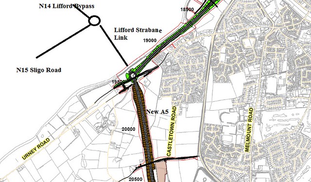
    I also have a drawing of the new Lifford-Strabane link road but I cant get my hands on it. Anyway is really simple; at the end of the new N14 which also bypasses Lifford a new roundabout is planned at the intersection of the N15. From this roundabout a short section will be build across the Finn connecting with another proposed roundabout on the A5. I have a sketch below.

    5221968932_965b4330e4_z.jpg

    My views are my own.


  • Registered Users, Registered Users 2 Posts: 1,108 ✭✭✭nordydan


    johnbk wrote: »

    There was a debate started from this thread I created:

    http://www.sabre-roads.org.uk/forum/viewtopic.php?t=19398

    Map now gone unfortunately!


  • Advertisement
  • Moderators, Entertainment Moderators, Science, Health & Environment Moderators Posts: 14,564 Mod ✭✭✭✭marno21


  • Moderators, Entertainment Moderators, Science, Health & Environment Moderators Posts: 14,564 Mod ✭✭✭✭marno21


  • Registered Users, Registered Users 2 Posts: 572 ✭✭✭annfield1978


    Halcrow Barry/ RPS JV due to be appointed for these three projects

    N13/N15 Balleybofey Bypass
    N14/N56 Relief Road
    N14 Letterkenny to Lifford


  • Moderators, Entertainment Moderators, Science, Health & Environment Moderators Posts: 14,564 Mod ✭✭✭✭marno21


    https://irl.eu-supply.com/ctm/Supplier/PublicTenders/ViewNotice/187380

    Tender awarded to RPS Halcrow Barry, as posted above by annfield1978.


  • Moderators, Entertainment Moderators, Science, Health & Environment Moderators Posts: 14,564 Mod ✭✭✭✭marno21


    TII are looking to perform traffic surveys this month along the relevant routes to this scheme:

    https://irl.eu-supply.com/app/rfq/publicpurchase_frameset.asp?PID=120002&B=ETENDERS_SIMPLE&PS=1&PP=ctm/Supplier/publictenders


  • Moderators, Entertainment Moderators, Science, Health & Environment Moderators Posts: 14,564 Mod ✭✭✭✭marno21


    Timeline for the advancement of this project, which includes the old N14/N15 to A5 Link bridge.

    Stage | Completion date
    Public consultation on route options | Q2 2018
    Preferred route selection | Q3 2018
    Completion of preliminary design | Q1 2020
    Publication of CPO & EIS | Q3 2020


  • Moderators, Entertainment Moderators, Science, Health & Environment Moderators Posts: 14,564 Mod ✭✭✭✭marno21


    Public consultation on this taking place next week:
    Donegal wrote:
    RPS CH2M Barry assessed the Constraints within the defined study areas for the Project and presented these to the public at a consultation held on 6th December 2017.

    The Design Team have taken feedback obtained during the consultation meetings and are currently progressing with the route selection process including the development and assessment of route options for the three Sections, which will be presented at public consultations to be held as follows:

    Where: When: Time:
    Radisson Blu, Letterkenny Tuesday 17th April 2018 2:00pm - 8:00pm
    County House,Donegal County Council, Lifford Wednesday 18th April 2018 2:00pm - 8:00pm
    Jacksons Hotel, Ballybofey Thursday 19th April, 2018 2:00pm - 8:00pm


    The Emerging Preferred Route will be identified during the second half of 2018 and presented to the public to obtain further feedback, prior to the Preferred Route being confirmed.

    Following confirmation of the Preferred Route, a Design and Environmental Impact Statement will be produced.

    Any comments/queries can be submitted via our online Feedback Form


  • Moderators, Entertainment Moderators, Science, Health & Environment Moderators Posts: 14,564 Mod ✭✭✭✭marno21


  • Moderators, Entertainment Moderators, Science, Health & Environment Moderators Posts: 14,564 Mod ✭✭✭✭marno21


    Publication of the emerging preferred route for this scheme has now been deferred to Q1 2019. As a result the project submission to An Bord Pleanala will not happen until the first half of 2021. That'll be 5 years for Phases 1-4


  • Moderators, Entertainment Moderators, Science, Health & Environment Moderators Posts: 14,564 Mod ✭✭✭✭marno21


    Public consultation on emerging preferred route in the next 2 weeks. Details at this link: http://www.donegal-ten-t.ie/pages/timelineandoutlook.php


  • Advertisement
  • Moderators, Science, Health & Environment Moderators Posts: 5,253 Mod ✭✭✭✭spacetweek


    Those consultations are taking place Tues-Thurs this week. But is a map of the preferred route available?


  • Moderators, Entertainment Moderators, Science, Health & Environment Moderators Posts: 14,564 Mod ✭✭✭✭marno21


    spacetweek wrote: »
    Those consultations are taking place Tues-Thurs this week. But is a map of the preferred route available?
    Nope but I expect to see it in the next week. That's what happened the last time anyway - documents were put online after the public sessions were complete.

    Hopefully no objections and it can go to ABP in 2021 as planned.


  • Registered Users, Registered Users 2 Posts: 2,023 ✭✭✭Donegal Storm


    From reading the Donegal Ten-T website, the preferred route won't now be announced until Q2 (which as we know probably means Q3) so I wouldn't be too hopeful


  • Moderators, Entertainment Moderators, Science, Health & Environment Moderators Posts: 14,564 Mod ✭✭✭✭marno21


    It's the emerging preferred route which is being announced this week, there will be a short period after this where any feedback will be taken into account from the public consultation and the final route will be announced then in Q2.


  • Moderators, Entertainment Moderators, Science, Health & Environment Moderators Posts: 14,564 Mod ✭✭✭✭marno21


  • Registered Users, Registered Users 2 Posts: 574 ✭✭✭Aontachtoir


    marno21 wrote: »

    Maybe I'm misreading it but it looks single carriageway to me. And no design at all for the bridge to join the A5?


  • Moderators, Entertainment Moderators, Science, Health & Environment Moderators Posts: 14,564 Mod ✭✭✭✭marno21


    Maybe I'm misreading it but it looks single carriageway to me. And no design at all for the bridge to join the A5?

    They're planning 2+2 as per the feasibility study, it definitely has the volumes for it anyway.

    The A5 bridge already has planning as far as I know, it was just mothballed until this and the A5 mainline were progressed


  • Moderators, Science, Health & Environment Moderators Posts: 5,253 Mod ✭✭✭✭spacetweek


    For sure it's 2+2 ,you wouldn't have slip lanes for the junction halfway along if it wasn't.

    It's very twisty and turny though.


  • Registered Users, Registered Users 2 Posts: 1,085 ✭✭✭riddlinrussell


    spacetweek wrote: »
    For sure it's 2+2 ,you wouldn't have slip lanes for the junction halfway along if it wasn't.

    It's very twisty and turny though.

    Yeah whats the craic with that bit near Letterkenny end where the current N14 is dead straight and the new road wiggles around it?


  • Advertisement
  • Registered Users, Registered Users 2 Posts: 1,015 ✭✭✭Kevwoody


    Yeah whats the craic with that bit near Letterkenny end where the current N14 is dead straight and the new road wiggles around it?


    At a guess I'd say it's to avoid as many houses as possible, also it's quite hilly terrain around there, so that'd be a factor too.

    Over that distance it won't be as twisty as it looks on the plans anyway.


  • Registered Users, Registered Users 2 Posts: 1,085 ✭✭✭riddlinrussell


    Kevwoody wrote: »
    At a guess I'd say it's to avoid as many houses as possible, also it's quite hilly terrain around there, so that'd be a factor too.

    Over that distance it won't be as twisty as it looks on the plans anyway.

    Oh it should smooth out, but I just looked at that section on streetview, have to imagine they are just keeping it as offline as possible to minimise disruption, because along that straight theres one abandoned farmhouse by the road, it only starts getting houses along the roadside as you get to the curve where you'd want to take it offline anyway to keep it straighter.


  • Registered Users, Registered Users 2 Posts: 2,023 ✭✭✭Donegal Storm


    spacetweek wrote: »
    For sure it's 2+2 ,you wouldn't have slip lanes for the junction halfway along if it wasn't.

    It's very twisty and turny though.

    No slip road there from what I can see, looks like LILO at best

    Screenshot-2019-03-01-at-20-26-50.png


  • Moderators, Entertainment Moderators, Science, Health & Environment Moderators Posts: 14,564 Mod ✭✭✭✭marno21


    Traffic on this route is 12k AADT. It'll definitely be 2+2, it's 2+2 as per feasibility study too.

    Ballybofey is getting 2+2 at 7k south of Ballybofey and 9k north of Ballybofey.


  • Moderators, Science, Health & Environment Moderators Posts: 5,253 Mod ✭✭✭✭spacetweek


    No slip road there from what I can see, looks like LILO at best
    LILOs are a type of slip road, though low quality.


  • Moderators, Entertainment Moderators, Science, Health & Environment Moderators Posts: 14,564 Mod ✭✭✭✭marno21


    spacetweek wrote: »
    LILOs are a type of slip road, though low quality.
    2+2s have either at grade roundabouts or "compact grade seperated" junctions (e.g. LILO pairs). This scheme is going for the latter + roundabouts at the N13 and A5 junctions.


  • Advertisement
  • Moderators, Entertainment Moderators, Science, Health & Environment Moderators Posts: 14,564 Mod ✭✭✭✭marno21


  • Moderators, Entertainment Moderators, Science, Health & Environment Moderators Posts: 14,564 Mod ✭✭✭✭marno21


  • Moderators, Entertainment Moderators, Science, Health & Environment Moderators Posts: 14,564 Mod ✭✭✭✭marno21


    Preferred route to be published in January.


  • Registered Users, Registered Users 2 Posts: 2,023 ✭✭✭Donegal Storm


  • Moderators, Entertainment Moderators, Science, Health & Environment Moderators Posts: 14,564 Mod ✭✭✭✭marno21


    Constant talk from Donegal about the lack of investment in both roads and infrastructure in the county. Then the Government comes along with a plan to plough €500m into new roads in Donegal, completing the most needed projects and relieving two massive bottlenecks, and the focus is on a small number of properties that will need to be CPOd for the road. Which should surprise no one given the unfettered sprawl that is observed in the county
    Letterkenny Cllr Donal Coyle campaigned on the Ten-T issue in last year’s local elections. he says there is no doubt that houses will be lost, and he says there will be other ramifications, particularly for farmers……


  • Advertisement
  • Moderators, Entertainment Moderators, Science, Health & Environment Moderators Posts: 14,564 Mod ✭✭✭✭marno21


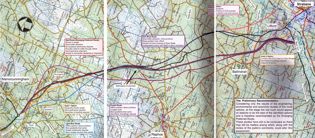
    Preferred route published. 17.6km of Type 2 dual carraigeway from the N13/N14 roundabout at Manorcunningham to the A5 link at Lifford-Strabane

    499954.jpg

    Route selection report and detailed drawings here: http://www.donegal-ten-t.ie/pages/documentsbrdownloads/options-selection-report.php

    This is Section 3.


  • Registered Users, Registered Users 2 Posts: 1,298 ✭✭✭Snotty


    marno21 wrote: »
    Preferred route published. 17.6km of Type 2 dual carraigeway from the N13/N14 roundabout at Manorcunningham to the A5 link at Lifford-Strabane

    499954.jpg

    Route selection report and detailed drawings here: http://www.donegal-ten-t.ie/pages/documentsbrdownloads/options-selection-report.php

    This is Section 3.

    Is there a NI project that will link up outside Lifford, from the map it looks like the road is ending in a field


  • Moderators, Entertainment Moderators, Science, Health & Environment Moderators Posts: 14,564 Mod ✭✭✭✭marno21


    Snotty wrote: »
    Is there a NI project that will link up outside Lifford, from the map it looks like the road is ending in a field

    Indeed there is, the cross border A5/N14 Link. Already has planning permission but not yet built, it’ll be the terminus of this scheme.


  • Registered Users, Registered Users 2 Posts: 1,085 ✭✭✭riddlinrussell


    And the main A5 scheme Strabane to Newbuildings (Derry essentially) will link in with the cross border link and should get shovels in the ground this year with a bit of luck


  • Registered Users, Registered Users 2 Posts: 1,298 ✭✭✭Snotty


    And the main A5 scheme Strabane to Newbuildings (Derry essentially) will link in with the cross border link and should get shovels in the ground this year with a bit of luck

    Will that bypass Strabane or will all that traffic go through the roundabout beside Asda?


  • Registered Users, Registered Users 2 Posts: 1,085 ✭✭✭riddlinrussell


    Snotty wrote: »
    Will that bypass Strabane or will all that traffic go through the roundabout beside Asda?

    So the planned A5 I believe will turn that roundabout into an overbridge, a new roundabout about 500m south of it will have the N14 exit, not sure where Strabane access will be, either to the south, further north or both.

    EDIT: Wesley Has the Junction layout for it here


  • Registered Users, Registered Users 2 Posts: 667 ✭✭✭BelfastVanMan


    Snotty wrote: »
    Will that bypass Strabane or will all that traffic go through the roundabout beside Asda?

    Newbuildings to Strabane is only Phase 1A; it will finish north of Strabane, and the bit bypassing Strabane itself
    ..Phase 2, which is Omagh South to Strabane North, will tie in the the new cross-border link.

    Won't be for some time yet..


  • Registered Users, Registered Users 2 Posts: 1,085 ✭✭✭riddlinrussell


    Newbuildings to Strabane is only Phase 1A; it will finish north of Strabane, and the bit bypassing Strabane itself
    ..Phase 2, which is Omagh South to Strabane North, will tie in the the new cross-border link.

    Won't be for some time yet..

    Apologies! I forgot that it was only to north of strabane :o


  • Registered Users, Registered Users 2 Posts: 6,085 ✭✭✭Chris_5339762


    I reckon the Omagh South to Strabane North will be the last bit to be done. Its the most expensive.


  • Registered Users, Registered Users 2 Posts: 667 ✭✭✭BelfastVanMan


    I reckon the Omagh South to Strabane North will be the last bit to be done. Its the most expensive.

    Phase 3; Ballygawley to the border, bypassing Auchnacloy is supposed to be the final section, but you may be right; depends how quickly those folks at Stormont get moving, and how soon the N2 from Ardee to the border is done.


  • Advertisement
Advertisement