Advertisement
If you have a new account but are having problems posting or verifying your account, please email us on hello@boards.ie for help. Thanks :)
Hello all! Please ensure that you are posting a new thread or question in the appropriate forum. The Feedback forum is overwhelmed with questions that are having to be moved elsewhere. If you need help to verify your account contact hello@boards.ie

Tropical Storm MARIA

Options
  • 06-09-2011 10:53pm
    #1
    Registered Users Posts: 1,318 ✭✭✭


    173490.gif

    000
    WTNT34 KNHC 062034
    TCPAT4

    BULLETIN
    TROPICAL DEPRESSION FOURTEEN ADVISORY NUMBER 1
    NWS NATIONAL HURRICANE CENTER MIAMI FL AL142011
    500 PM AST TUE SEP 06 2011

    ...NEW TROPICAL DEPRESSION FORMS IN THE FAR EASTERN ATLANTIC...


    SUMMARY OF 500 PM AST...2100 UTC...INFORMATION
    LOCATION...11.8N 37.0W
    ABOUT 920 MI...1480 KM WSW OF THE CAPE VERDE ISLANDS
    ABOUT 1650 MI...2655 KM E OF THE LESSER ANTILLES
    MAXIMUM SUSTAINED WINDS...35 MPH...55 KM/H
    PRESENT MOVEMENT...WNW OR 285 DEGREES AT 18 MPH...30 KM/H
    MINIMUM CENTRAL PRESSURE...1008 MB...29.77 INCHES


    WATCHES AND WARNINGS
    THERE ARE NO COASTAL WATCHES OR WARNINGS IN EFFECT.


    DISCUSSION AND 48-HOUR OUTLOOK
    AT 500 PM AST...2100 UTC...THE CENTER OF NEWLY FORMED TROPICAL
    DEPRESSION FOURTEEN WAS LOCATED NEAR LATITUDE 11.8 NORTH...
    LONGITUDE 37.0 WEST. THE DEPRESSION IS MOVING TOWARD THE
    WEST-NORTHWEST NEAR 18 MPH...30 KM/H...AND THIS GENERAL MOTION IS
    EXPECTED TO CONTINUE DURING THE NEXT TWO DAYS.

    MAXIMUM SUSTAINED WINDS ARE NEAR 35 MPH...55 KM/H...WITH HIGHER
    GUSTS. SOME STRENGTHENING IS FORECAST DURING THE NEXT 48 HOURS AND
    THE DEPRESION COULD BECOME A TROPICAL STORM TONIGHT OR WEDNESDAY.

    ESTIMATED MINIMUM CENTRAL PRESSURE IS 1008 MB...29.77 INCHES.


    HAZARDS AFFECTING LAND
    NONE


    NEXT ADVISORY
    NEXT COMPLETE ADVISORY...1100 PM AST.

    $$
    FORECASTER AVILA


    Looks like this one could take a track like Irene. Too early to say though.
    Should become Maria pretty soon.


Comments

  • Registered Users Posts: 1,318 ✭✭✭snowstreams


    It has now been upgraded to Tropical Storm status and named Maria.


  • Closed Accounts Posts: 6,388 ✭✭✭gbee


    Maria, MARIA, Mar IIIIIII aaa ♪♪♪ ♪♪ ♫♫♫ :)


  • Registered Users Posts: 20,362 ✭✭✭✭Rikand


  • Banned (with Prison Access) Posts: 25,234 ✭✭✭✭Sponge Bob


    Jet stream will get it on Saturday and it will be in over us next monday I reckon!


  • Registered Users Posts: 179 ✭✭odyboody


    With the gulf stream reportedly already slowed to nearly a stop what effect will these storms have?
    Will they suck the last of the heat energy out thus causing a complete stop?
    Maybe we will find out the day after tomorrow.:rolleyes:


  • Advertisement
  • Registered Users Posts: 10,519 ✭✭✭✭dsmythy


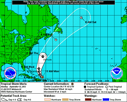
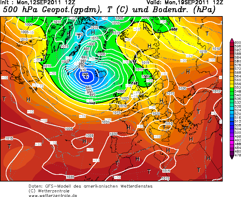
    Maria looks like being, for the most part, a swing and a miss for Ireland. Far east Canada might be lucky/unlucky enough to see something.


    mariamiss2.gif


    mariamiss1.png


  • Registered Users Posts: 9,233 ✭✭✭sdanseo


    I dunno, the NHC forecasts for this one have been all over the place. They've released forecasts for it reach hurricane strength 2 or 3 times and fallen back to its current rating each time.

    Looks like Iceland is gonna get belted though.


  • Registered Users Posts: 2,604 ✭✭✭200motels


    odyboody wrote: »
    With the gulf stream reportedly already slowed to nearly a stop what effect will these storms have?
    Will they suck the last of the heat energy out thus causing a complete stop?
    Maybe we will find out the day after tomorrow.:rolleyes:
    Has it nearly stopped? That's the first I heard of it. Could you explain why this has happened?


  • Registered Users Posts: 179 ✭✭odyboody


    Its a variable current which historically speeds up and slows down. Interesting discussion thread here http://forum.netweather.tv/topic/61131-north-atlantic-drift-jet-stream-slowing-downconsequences/
    The last bit a out the oil spill reeks of scare mongering however


  • Registered Users Posts: 9,233 ✭✭✭sdanseo


    Upgrade imminent according to this - 70mph sustained winds at present.

    173543W5_NL_sm.gif


  • Advertisement
  • Registered Users Posts: 9,233 ✭✭✭sdanseo


    And she's now a hurricane.
    000
    WTNT34 KNHC 152044
    TCPAT4

    BULLETIN
    HURRICANE MARIA ADVISORY NUMBER 37
    NWS NATIONAL HURRICANE CENTER MIAMI FL AL142011
    500 PM AST THU SEP 15 2011

    ...MARIA BECOMES THE THIRD HURRICANE OF THE SEASON...HURRICANE WATCH
    AND TROPICAL STORM WARNING ISSUED FOR SOUTHEASTERN NEWFOUNDLAND...


    SUMMARY OF 500 PM AST...2100 UTC...INFORMATION

    LOCATION...35.2N 65.6W
    ABOUT 205 MI...330 KM NNW OF BERMUDA
    ABOUT 1025 MI...1650 KM SW OF CAPE RACE NEWFOUNDLAND
    MAXIMUM SUSTAINED WINDS...75 MPH...120 KM/H
    PRESENT MOVEMENT...NNE OR 30 DEGREES AT 36 MPH...57 KM/H
    MINIMUM CENTRAL PRESSURE...987 MB...29.15 INCHES


    WATCHES AND WARNINGS
    CHANGES IN WATCHES AND WARNINGS WITH THIS ADVISORY...

    ENVIRONMENT CANADA HAS ISSUED A HURRICANE WATCH FOR THE AVALON
    PENINSULA OF NEWFOUNDLAND FROM ARNOLDS COVE TO BRIGUS SOUTH AND A
    TROPICAL STORM WARNING FOR THE ENTIRE AVALON PENINSULA FROM ARNOLDS
    COVE TO JONES HARBOR.

    THE BERMUDA WEATHER SERVICE HAS DISCONTINUED THE TROPICAL STORM
    WARNING FOR BERMUDA.

    SUMMARY OF WATCHES AND WARNINGS IN EFFECT...

    A HURRICANE WATCH IS IN EFFECT FOR...
    * NEWFOUNDLAND FROM ARNOLDS COVE TO BRIGUS SOUTH.

    A TROPICAL STORM WARNING IS IN EFFECT FOR...
    * NEWFOUNDLAND FROM ARNOLDS COVE TO JONES HARBOR.

    A HURRICANE WATCH MEANS THAT HURRICANE CONDITIONS ARE POSSIBLE
    WITHIN THE WATCH AREA...IN THIS CASE WITHIN 24 HOURS.

    A TROPICAL STORM WARNING MEANS THAT TROPICAL STORM CONDITIONS ARE
    EXPECTED WITHIN THE WARNING AREA...IN THIS CASE WITHIN 24 HOURS.

    A HURRICANE WARNING COULD BE REQUIRED FOR A PORTION OF AVALON
    PENINSULA THIS EVENING.

    FOR STORM INFORMATION SPECIFIC TO YOUR AREA...PLEASE MONITOR
    PRODUCTS ISSUED BY YOUR NATIONAL METEOROLOGICAL SERVICE.


    DISCUSSION AND 48-HOUR OUTLOOK
    AT 500 PM AST...2100 UTC...THE CENTER OF HURRICANE MARIA WAS LOCATED
    NEAR LATITUDE 35.2 NORTH...LONGITUDE 65.6 WEST. MARIA IS MOVING
    TOWARD THE NORTH-NORTHEAST NEAR 36 MPH...57 KM/H. THIS MOTION IS
    EXPECTED TO CONTINUE TONIGHT...WITH A TURN TO THE NORTHEAST AT AN
    EVEN FASTER FORWARD SPEED EXPECTED ON FRIDAY. ON THE FORECAST
    TRACK...THE CENTER OF MARIA WILL PASS NEAR OR OVER THE AVALON
    PENINSULA ON FRIDAY.

    MAXIMUM SUSTAINED WINDS HAVE INCREASED TO NEAR 75 MPH...120
    KM/H...WITH HIGHER GUSTS. MARIA IS A CATEGORY ONE HURRICANE ON THE
    SAFFIR-SIMPSON HURRICANE WIND SCALE. SADDITIONAL STRENGTHENING IS
    POSSIBLE OVERNIGHT BEFORE WEAKENING LIKELY BEGINS LATER ON FRIDAY.

    HURRICANE FORCE WINDS EXTEND OUTWARD UP TO 45 MILES...75 KM...FROM
    THE CENTER...AND TROPICAL STORM FORCE WINDS EXTEND OUTWARD UP TO 240
    MILES...390 KM.

    ESTIMATED MINIMUM CENTRAL PRESSURE IS 987 MB...29.15 INCHES.


    HAZARDS AFFECTING LAND
    WIND...TROPICAL STORM CONDITIONS ARE EXPECTED TO BEGIN IN THE
    WARNING AREA ON FRIDAY MORNING. HURRICANE CONDITIONS ARE POSSIBLE
    IN THE WATCH AREA BY FRIDAY AFTERNOON.

    RAINFALL...RAINFALL AMOUNTS OF 1 TO 3 INCHES CAN BE EXPECTED ACROSS
    SOUTHEASTERN NEWFOUNDLAND ASSOCIATED WITH MARIA.

    STORM SURGE...COASTAL FLOODING IS EXPECTED NEAR AND TO THE EAST OF
    WHERE THE CENTER MAKES LANDFALL. NEAR THE COAST...THE SURGE WILL
    BE ACCOMPANIED BY LARGE AND DESTRUCTIVE WAVES.


    NEXT ADVISORY
    NEXT INTERMEDIATE ADVISORY...800 PM AST.
    NEXT COMPLETE ADVISORY...1100 PM AST.

    $$
    FORECASTER BLAKE/BEVEN


  • Registered Users Posts: 10,519 ✭✭✭✭dsmythy


    Becoming potentially dangerous for Newfoundland.


  • Registered Users Posts: 2,988 ✭✭✭dirtyghettokid


    newfoundland not so bad guys

    the weather network reports:
    September 16, 2011 — Hurricane Maria made landfall in southeastern Newfoundland Friday afternoon, but fortunately the wind and rain fell short of predictions.

    It wasn't a storm to tell the grandkids about.
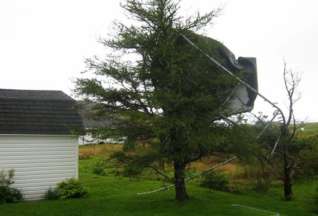
    Hurricane Maria made landfall in southeastern Newfoundland Friday, making for a blustery and wet afternoon but not the widespread damage and flooding that had been feared.
    The storm made landfall as a category 1 hurricane in the vicinity of St. Mary's Bay around 3:30 p.m. NDT Friday, generating pounding surf and dumping heavy rain over the southeastern Avalon Peninsula.
    The Canadian Hurricane Centre had warned of the potential for wind gusts up to 120 km/h. However, even the strongest gusts fell short of hurricane strength.
    Cape Race and St. Pierre saw the strongest winds, reporting gusts of 80 km/h as Maria came onshore. St. Pierre also saw the most rain -- about 60 mm.
    Winds began picking up in St. John's Friday evening behind the storm. Gusts up to 80 km/h were reported at the International Airport.
    Schools were closed as a precaution Friday. Flights had also been cancelled earlier in the day, but were running again with some delays by mid-afternoon.

    Fishermen in Burin hauled up their boats ahead of Maria's arrival
    Some residents had been concerned that Maria would be another Hurricane Igor. Igor caused widespread destruction on the Avalon almost a year to the day that Maria made landfall.
    Robert Hiscock, chief administrative officer of Clarenville, said he got an “anxious feeling” when he heard Maria was tracking straight towards Newfoundland.
    Clarenville was badly flooded during Igor, but the town has made improvements to its drainage system in the past year, and Hiscock said engineers and RCMP were ready to respond in an emergency.
    Strong winds are expected to persist over the Avalon into Saturday as Maria merges with a large non-tropical low.

    http://www.theweathernetwork.com/news/storm_watch_stories3&stormfile=hurricane_maria_to_make_land_160911?ref=twitternews


  • Registered Users Posts: 10,519 ✭✭✭✭dsmythy


Advertisement