Advertisement
If you have a new account but are having problems posting or verifying your account, please email us on hello@boards.ie for help. Thanks :)
Hello all! Please ensure that you are posting a new thread or question in the appropriate forum. The Feedback forum is overwhelmed with questions that are having to be moved elsewhere. If you need help to verify your account contact hello@boards.ie

Photographing around the city-recommendations?

Options
  • 15-02-2012 5:46pm
    #1
    Registered Users Posts: 8,138 ✭✭✭


    HI,
    I've booked a day off work soon and am going to wander around the city taking photos. I'm just looking for ideas for less-thought of places/good locations.
    I've done the docks, salthill, general city center, market, cathedral, eyre square etc.
    Any ideas or suggestions, inclulding-
    old/abondended buildings (Great Southern hotel seems impossible to enter)
    any high up vantage points (in buildings or elsewhere)

    Cheers in advance,
    Pa.


Comments

  • Banned (with Prison Access) Posts: 31,117 ✭✭✭✭snubbleste


    Put on a diving suit.. there exists the river, canals, loughs, docks, and the bay.


  • Closed Accounts Posts: 902 ✭✭✭scholar007


    Try Long Walk - Ya might get a pic or two of some Ghosties


    http://galwayindependent.com/stories...-causes-a-stir


  • Registered Users Posts: 6,220 ✭✭✭bonzodog2


    The canal and other minor waterways, and the remaining evidence of the rail line to Clifden.


  • Registered Users Posts: 8,138 ✭✭✭dinneenp


    bonzodog2 wrote: »
    The canal and other minor waterways, and the remaining evidence of the rail line to Clifden.
    Cheers
    Where is that?
    Pa


  • Registered Users Posts: 6,220 ✭✭✭bonzodog2


    If you walk the path to Renmore from the bus station you will see a couple of bridges, near a rail turntable.
    The Clifden line used to cross the river upstream from the SalmonWeir bridge, the rail bridge was demolished in 1936, but the stone piers remain. There is also an embankment between there and Dyke Rd.
    There is supposedly a bit of a tunnel remaining, under Shannon dry cleaners in Bohermore, don't know if they'll let you see it.


  • Advertisement
  • Registered Users Posts: 4,391 ✭✭✭inisboffin


    Water works building on Dyke road is kinda cool. Menlo castle.


  • Registered Users Posts: 147 ✭✭loser2old4board


    Start at Waterside in Woodquay, follow the river bank all the way down to the Spanish Arch.
    Take a walk out to Nimmo's Pier, also the causeway out to Mutton Island.
    The diving tower out in Blackrock, Salthill. Also find the slipway where they launch the life boat from, down passed the docks, near the bus depots.
    Try if the people who run the Fisheries will let you walk out on the causeway over the weir near the Salmon Weir bridge.
    You will get some different views/shots of the city from those vantage points.


  • Registered Users Posts: 1,842 ✭✭✭Rob A. Bank


    The UCG old building is photogenic and while you are there walk along the path beside the riverbank as far as the playing pitches across from Menlo Castle.

    Plenty of nature photo ops there and still within the city limits.


  • Registered Users Posts: 8,138 ✭✭✭dinneenp


    inisboffin wrote: »
    Water works building on Dyke road is kinda cool. Menlo castle.

    might well try that. I have a new macro lens so could go for some nature/floral shots.
    also the swans etc. along by Claddagh, diving board in Blackrock, hopefully some people diving in (but doubt it).
    Cheers.
    the 26th is the day I'm off so I'll post up some shots afterwards.


  • Closed Accounts Posts: 3,689 ✭✭✭joeKel73


    26th won't be good for getting people diving off blackrock, high tide will be around 7.30am and 8pm, so too early and late. Would probably get a few out for their morning swim though!


  • Advertisement
  • Registered Users Posts: 8,138 ✭✭✭dinneenp


    thanks for all the suggestions.
    I had to change and it's tomorrow I'm off.
    Here's some bits on my list (not everything):
    • graffiti behind Roisin Dubh
    • Corrib Great Southern (no, won't be able to get into the building)
    • Walk from Woodquay to Claddagh and all along there...
    • NUIG river walk (I like the 'new' building, 'accross' the road from Kingfisher)
    • Beach, Salthill
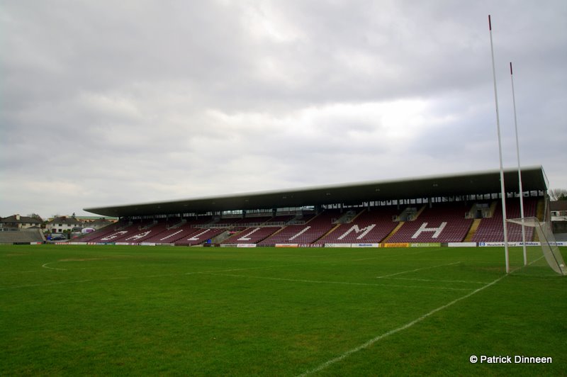
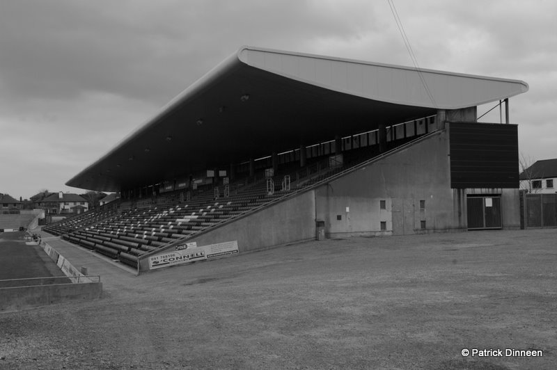
    • Pearce Stadium (if I can get inside)
    • Bothermore boarded up houses

    I'll update and post a few photos when done.


  • Registered Users Posts: 8,138 ✭✭✭dinneenp


    Start at Waterside in Woodquay, follow the river bank all the way down to the Spanish Arch.
    Take a walk out to Nimmo's Pier, also the causeway out to Mutton Island.
    The diving tower out in Blackrock, Salthill. Also find the slipway where they launch the life boat from, down passed the docks, near the bus depots.
    Try if the people who run the Fisheries will let you walk out on the causeway over the weir near the Salmon Weir bridge.
    You will get some different views/shots of the city from those vantage points.

    cheers.
    Where is the slipway? Is it somewhere between the docks and petrol station (by Ce Na Mara apts?)
    Where are the people who run the fisheries, i'd like to ask them but do they have a central location/office?


  • Registered Users Posts: 8,138 ✭✭✭dinneenp


    inisboffin wrote: »
    Water works building on Dyke road is kinda cool. Menlo castle.

    is this the waterworks?
    http://www.flickr.com/photos/marina0195/2306217166/


  • Closed Accounts Posts: 3 the happyhammer


    dinneenp wrote: »
    thanks for all the suggestions.
    I had to change and it's tomorrow I'm off.

    Here's some bits on my list (not everything):
    • graffiti behind Roisin Dubh
    • Corrib Great Southern (no, won't be able to get into the building)
    • Walk from Woodquay to Claddagh and all along there...
    • NUIG river walk (I like the 'new' building, 'accross' the road from Kingfisher)
    • Beach, Salthill
    • Pearce Stadium (if I can get inside)
    • Bothermore boarded up houses
    I'll update and post a few photos when done.
    boarded up houses in bohermore????????


  • Registered Users Posts: 8,138 ✭✭✭dinneenp


    boarded up houses in bohermore????????

    There's three houses on Bohermore Road that are boarded up. I jut drove past and noticed that it could be a good shot, thin they might be different colour houses.
    Would need no cars to be parked in front of them though.


  • Registered Users Posts: 147 ✭✭loser2old4board


    The lifeboat launch slipway is down around the dock area. There is a roadway that goes down passed the big oil tanks down towards where the bus companies park their buses.
    A turn off to the right leads down to the slipway. There is a lot of warehouses down around that area. Sorry I can't be more specific and I don't how to give a link from google maps.
    Maybe just ask if your are down around there. The whole area is just marked as 'Dun Aengus Dock' on Google Maps so it's not much help. It's directly across the river mouth from Nimmo's Pier.

    AFAIK the Fisheries building is what looks like a white house on your left as you look towards the wier from the bridge. You can get to it from the Fishieries Field (Arts Festival Big Top).
    I dont't have any contacts but maybe stroll in if it's open and ask.
    Enjoy the day. Hope it's good weather.


  • Registered Users Posts: 8,138 ✭✭✭dinneenp


    I mainly ended up at Salthill diving boards and Pearse stadium, will post up more soon


    Pearse-Stand-Galway-GAA.jpg

    Galway-GAA-stadium.jpg


  • Registered Users Posts: 4,391 ✭✭✭inisboffin


    dinneenp wrote: »

    Yes, that's the place. Looks great in evening light.


  • Registered Users Posts: 25,967 ✭✭✭✭Mrs OBumble


    The lifeboat launch slipway is down around the dock area. There is a roadway that goes down passed the big oil tanks down towards where the bus companies park their buses.
    A turn off to the right leads down to the slipway. There is a lot of warehouses down around that area. Sorry I can't be more specific and I don't how to give a link from google maps.

    For future reference .. it's near number 34 on the Harbour Enterprise Park layout map.

    There's actually a road that Google maps doesn't have (and the road that they show as Dun Aengus dock doesn't quite exist :-) No 34 is on the left side of that road, and the slipway is on the right at the end.

    I didn't put it on the map 'cos I thought it might be one of those places that it's best not to publicise. Open to advice whether it should be added or not.


  • Registered Users Posts: 8,138 ✭✭✭dinneenp


    dinneenp wrote: »
    There's three houses on Bohermore Road that are boarded up. I jut drove past and noticed that it could be a good shot, thin they might be different colour houses.
    Would need no cars to be parked in front of them though.

    6957457063_fb2191eb39_b.jpg
    Galway recession? by Photoblog.ie (Patrick Dinneen), on Flickr


  • Advertisement
  • Registered Users Posts: 8,138 ✭✭✭dinneenp


  • Closed Accounts Posts: 3,689 ✭✭✭joeKel73


    Love #2 of that batch - I reckon it would look really well in B&W...


  • Registered Users Posts: 8,138 ✭✭✭dinneenp


  • Registered Users Posts: 5,641 ✭✭✭zero19


    Did you check for ghosts? :D


  • Registered Users Posts: 7,239 ✭✭✭KittyeeTrix


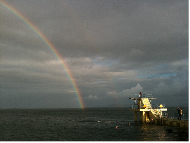
    I got a picture of a rainbow next to the diving boards last year....It was taken on my phone so the quality is not great and I've no idea how to re-size but sure, have a look anyway:)

    Waaaaaaay too big. Will need to figure out how to resize and try again

    Diving_Board_rainbow.png
    That's better!!!


Advertisement