Advertisement
If you have a new account but are having problems posting or verifying your account, please email us on hello@boards.ie for help. Thanks :)
Hello all! Please ensure that you are posting a new thread or question in the appropriate forum. The Feedback forum is overwhelmed with questions that are having to be moved elsewhere. If you need help to verify your account contact hello@boards.ie

Thunderstorm/Convective Watch - Spring/Summer 2012

Options
1697072747589

Comments

  • Closed Accounts Posts: 2,693 ✭✭✭Redsunset


    Jpmarn wrote: »
    Looking at the radar the areas getting >16mm ph are pretty small.

    You can get imbedded thundery cells that can cause serious damage with torrential rain. That's why we also have the term LOCALISED flooding. The most serious of weather events around Europe often happen like this.


  • Closed Accounts Posts: 1,220 ✭✭✭Davaeo09


    Min wrote: »
    That whole system went to the west of Kilkenny, which was great as we didn't need the rainfall, the lightning would be great without the rain...fixes nitrogen so a bit of free fertilizer.
    So yeah the Hirlam was pretty accurate, I just pity the poor farmers who got all that rainfall, the radar said it all.

    I certainly heard thunder here near Kilmanagh about 10km's from Kilkenny. Must have been about 5am I guess and it was lashing rain.


  • Registered Users Posts: 2,236 ✭✭✭MrFrisp


    Cork is actually drop dead boring today with regards to the weather.

    Kinda bright,cloudy...But dry..:mad:

    Boring...


    .


  • Registered Users Posts: 5,068 ✭✭✭Iancar29


    Some cells firing up moving across dublin now :)


  • Closed Accounts Posts: 5,550 ✭✭✭Min


    Davaeo09 wrote: »
    I certainly heard thunder here near Kilmanagh about 10km's from Kilkenny. Must have been about 5am I guess and it was lashing rain.

    The western third of the county would have been on the eastern edge of it alright, 6 miles north east of Kilkenny and we had just 3mm heaviest at 3.6mm/hr at 1.36am so we avoided it.
    Looked intense alright for those in it.


  • Advertisement
  • Registered Users Posts: 24,205 ✭✭✭✭Larbre34


    Iancar29 wrote: »
    Some cells firing up moving across dublin now :)

    Yes indeed, that colourful return just hit Dublin 15, torrential rain for about 10 mins, no sparks. Hoping we get some of what the midlands got this morning before the day is out. Conditions are very good


  • Registered Users Posts: 8,720 ✭✭✭Hal1


    Some organised showers starting to develop around Kilkenny into Laois.


  • Moderators, Home & Garden Moderators, Science, Health & Environment Moderators Posts: 17,998 Mod ✭✭✭✭DOCARCH


    Iancar29 wrote: »
    Some cells firing up moving across dublin now :)

    Once again it looks like they might slip away north rather than towards the city! :(


  • Registered Users Posts: 6,700 ✭✭✭Mountainsandh


    Haven't caught up with the thread, there might be others from my area. I'm near enough to Ballymacarbry, Co Waterford, but more on the side of the Knockmealdowns (Knocknafallia area). We had a real bad storm this morning, from approx 5.30 untill 6.30.
    An almighty crack/bang woke us at 5/5.30 am, and it takes a lot to wake Mr Mountain... It had been raining heavily on and off all night (I think), but the morning was deluvial.
    I lost count of the lightning strikes, would have taken pics, but I couldn't locate where exactly it was hitting it was everywhere.
    I think the initial hit that woke us must have been the one that grilled our phone connection, internet modem (separate from phone line), and satellite box. The internet router got hit too, we had no surge protection, and I dread to discover more things that might have blown.
    Thankfully I have a dongle, and the laptops are working.
    I took a very short video, I think I'll have to wait to upload it anywhere though. The little roads around us look like riverbeds this morning.
    It was great to experience, it's a pain to try and get everything fixed now though.:(

    edit : anyone got a link to this thing that shows where lightning struck ? thanks
    edit again : found the met eireann one, but that doesn't seem to show 13/08, anyone know what time they'll publish it at ?


  • Registered Users Posts: 1,033 ✭✭✭Simon Gruber Says


    Haven't caught up with the thread, there might be others from my area. I'm near enough to Ballymacarbry, Co Waterford, but more on the side of the Knockmealdowns (Knocknafallia area). We had a real bad storm this morning, from approx 5.30 untill 6.30.
    An almighty crack/bang woke us at 5/5.30 am, and it takes a lot to wake Mr Mountain... It had been raining heavily on and off all night (I think), but the morning was deluvial.
    I lost count of the lightning strikes, would have taken pics, but I couldn't locate where exactly it was hitting it was everywhere.
    I think the initial hit that woke us must have been the one that grilled our phone connection, internet modem (separate from phone line), and satellite box. The internet router got hit too, we had no surge protection, and I dread to discover more things that might have blown.
    Thankfully I have a dongle, and the laptops are working.
    I took a very short video, I think I'll have to wait to upload it anywhere though. The little roads around us look like riverbeds this morning.
    It was great to experience, it's a pain to try and get everything fixed now though.:(

    edit : anyone got a link to this thing that shows where lightning struck ? thanks


    The yellow ones are from the storm this morning.

    http://andvari.vedur.is/athuganir/eldingar/i_dag_na.html


  • Advertisement
  • Closed Accounts Posts: 5,150 ✭✭✭Deep Easterly


    DOCARCH wrote: »
    Drizzle storm and lots of slugs here - that's about the height of excitment this morning in south Dublin! :rolleyes:

    Even though we live on totally opposite sides of the country we have a surprisingly similar climate! :D

    :o


  • Registered Users Posts: 356 ✭✭Strangegravy


    Thought I heard a couple of low rumbles here in Limerick about an hour or so ago... Lightning maps show strikes nearby alright. Well jealous of that big storm this morning though, sounded epic!


  • Closed Accounts Posts: 3,548 ✭✭✭Harps


    anyone got a link to this thing that shows where lightning struck ? thanks
    edit again : found the met eireann one, but that doesn't seem to show 13/08, anyone know what time they'll publish it at ?

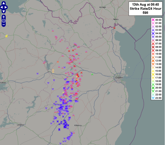
    Here's one taken from the IWN forum, almost 600 lightning strikes recorded

    lightning.png


  • Registered Users Posts: 14,517 ✭✭✭✭M.T. Cranium


    The storm in east Clare seems to be developing and moving NNE, across east Galway and south Roscommon. DE, are you in the path?

    Could be a hail producer, any obs appreciated along the track, storm chase opportunity for Galway (region) based members who can scramble now. Will try to assist if anyone does chase (assuming you have mobile, that is).


  • Registered Users Posts: 613 ✭✭✭rodge68


    You would not believe the rain that is falling here in east clare, floods all over the fields and my garden is flooding !!!!! Must give Noah a ring for a lift !!


  • Closed Accounts Posts: 4,279 ✭✭✭Su Campu


    The only TAFs forecasting thunder are Belfast Aldergrove and City, heavy thunderstorms with hail, up to 10 pm. Met Eireann's local forecast for Galway Airport mentions NSW (No Significant Weather) up to midnight but I'd say that will be amended.


  • Registered Users Posts: 14,517 ✭✭✭✭M.T. Cranium


    For anyone mobile or in this area, storm track appears to be approximately Athenry (soon) to Roscommon town (8 pm) although a forward cell may be in between those locations now and into Roscommon town by 7:15 pm. Any possible storm intercept should occur in that zone given daylight considerations.

    I am unfortunately now off-line for rest of calendar day.


  • Registered Users Posts: 48,247 ✭✭✭✭km79


    For anyone mobile or in this area, storm track appears to be approximately Athenry (soon) to Roscommon town (8 pm) although a forward cell may be in between those locations now and into Roscommon town by 7:15 pm. Any possible storm intercept should occur in that zone given daylight considerations.

    I am unfortunately now off-line for rest of calendar day.
    Yeah just ended here ( I hope ) east of athenry. No thunder and lightning just 10 mm of rain 


  • Registered Users Posts: 1,583 ✭✭✭davehey79


    Heavens have opened here in Longford in the last 10 mins wonder will there be any rumbles and sparks to go with it


  • Closed Accounts Posts: 3,548 ✭✭✭Harps


    Severe shower train moving due north through northern Ireland at the moment, definitely going to be serious localised flooding from it

    36822313.png


  • Advertisement
  • Registered Users Posts: 845 ✭✭✭tylercollins


    Just back in from watching that cross over from Co. Antrim into Donegal and it looked awesome from my point of view! Seen a couple of strikes from it as well as indicated in that chart.

    Nothing hugely spectacular, but you can see the rain moving over Inishowen from Castlerock / Magilligan


  • Closed Accounts Posts: 4,279 ✭✭✭Su Campu


    Met Eireann have a yellow alert out on Meteoalarm for thunderstorms over the whole country today. Cork's latest TAF

    (CORK)TAF EICK 140500Z 1406/1506 20012KT 9999 SCT003 BKN005 TEMPO 1406/1408 3000 SHRA TSRA SCT001 BKN003 SCT018CB PROB30 TEMPO 1406/1408 0400 FG BKN001 BECMG 1409/1411 SCT012 BKN018 TEMPO 1409/1415 SCT008 BKN012 SCT018CB BECMG 1412/1415 16012KT BECMG 1421/1424 09015KT 4000 -RADZ BKN003 OVC005 BECMG 1503/1506 09020G32KT=


  • Registered Users Posts: 5,068 ✭✭✭Iancar29


    Some nice developing CBs going up around here now :)


  • Banned (with Prison Access) Posts: 25,234 ✭✭✭✭Sponge Bob


    Estofex warning on the genesis of the Weds storm, the forecast period below is while the storm is to our south and Estofex have not warned about Ireland yet.
    DISCUSSION

    ... NW Iberia into parts of W Europe ...

    A well-defined DCVA will be a focus for convective activity on the western flank on the blocking area. A sharp trough is pushed from Atlantic towards NW Iberia where strong mid-level jet rounds its base and creating favorable strong shear for organized storms. 20-30 m/s of deep layer shear will result in the afternoon/overnight hours. Marginal instability will become available along the front, so expect severe storms to take place posing threat for large hail, intense rain and damaging winds. A tornado or two is also possible given the strongly enhanced LL shear/helicity just ahead of the cold frontal boundary. This threat seem maximized towards the evening hours before activity spread northwards towards UK overnight. Extreme NW France towards SW UK were also included into the level 1 area given the some threat for especially severe winds, excessive rainfalls and possibly a tornado as both SREH and LL shear remain high overnight.


  • Registered Users Posts: 1,204 ✭✭✭eskimocat


    We have Thunder!!!! and a right auld bang of it too! Moving in over Collooney at the moment, eyes peeled for any lightning! Plenty rain with it too.


  • Registered Users Posts: 1,248 ✭✭✭rhonin


    eskimocat wrote: »
    We have Thunder!!!! and a right auld bang of it too! Moving in over Collooney at the moment, eyes peeled for any lightning! Plenty rain with it too.

    Heard that one too. Very heavy rain now.


  • Closed Accounts Posts: 6,388 ✭✭✭gbee


    My view this morning


  • Registered Users Posts: 5,068 ✭✭✭Iancar29


    Cells kicking off in the north again!!! GRRRR!!!


  • Closed Accounts Posts: 592 ✭✭✭hotwhiskey


    Iancar29 wrote: »
    Cells kicking off in the north again!!! GRRRR!!!

    Ya it was eventful night here last night with torrential rain washing stones from many a bye lane leaving mounds of gravel at the bottom of hills here. The lightening show was epic in the night sky red, white and blue colors leaving me like this :pac: the lightening was not intense but it did bring back memory's of 85'.


  • Advertisement
  • Registered Users Posts: 845 ✭✭✭tylercollins


    Couple of rumbles of thunder here about an hour a go and torrential rain. Some great convection can be seen looking south east! I would for a thunder and lighting show at night time!


This discussion has been closed.
Advertisement