Advertisement
If you have a new account but are having problems posting or verifying your account, please email us on hello@boards.ie for help. Thanks :)
Hello all! Please ensure that you are posting a new thread or question in the appropriate forum. The Feedback forum is overwhelmed with questions that are having to be moved elsewhere. If you need help to verify your account contact hello@boards.ie

Seen & Found

Options
1101113151632

Comments

  • Moderators, Science, Health & Environment Moderators, Society & Culture Moderators Posts: 60,159 Mod ✭✭✭✭Wibbs


    pueblo wrote: »
    I have shown the pictures to a local archaeologist friend who thinks this is a late Mesolithic butt trimmed flake.

    Anyone care to chip in?
    Yea looking at it again, I'm less sure of the core label. I can only see two possible flakes that came off and even then. The striking platform if it is one doesn't work for me either.

    Rejoice in the awareness of feeling stupid, for that’s how you end up learning new things. If you’re not aware you’re stupid, you probably are.


  • Moderators, Science, Health & Environment Moderators Posts: 5,220 Mod ✭✭✭✭slowburner


    Most folks here are probably already aware of this LIDAR discovery but it's worth a look anyway.
    http://www.pasthorizonspr.com/index.php/archives/09/2013/new-passage-tomb-discovery-near-newgrange?goback=.gde_1189897_member_273187015#!


  • Registered Users Posts: 728 ✭✭✭pueblo


    Found this today, I have no idea ...but I'm hoping it's a Bronze age copper or bronze alloy flat chisel :-)

    It doesn't attract a magnet. It's 242mm long, 34mm wide and 18mm deep. It weighs 266g One side is flat and smooth with a sort of waxy texture while the opposite side is undulating, uneven and rough. Both ends terminate in a sloping 'chisel' shape.

    Chisel%202.jpg


    Chisel%201.jpg


  • Registered Users Posts: 1,021 ✭✭✭Coles


    Any thoughts on what process causes a mark such as the one running through these fields (the wide swath running roughly west to east). Pipeline works of some sort?

    http://maps.osi.ie/publicviewer/#V1,700279,753455,6,0


  • Registered Users Posts: 776 ✭✭✭Fries-With-That


    Coles wrote: »
    Any thoughts on what process causes a mark such as the one running through these fields (the wide swath running roughly west to east). Pipeline works of some sort?

    http://maps.osi.ie/publicviewer/#V1,700279,753455,6,0

    I think it may be something to do with some kind of a proposed (past or future) linking of the N2 and M3.


  • Advertisement
  • Registered Users Posts: 3,590 ✭✭✭cfuserkildare


    Just noticed another object.

    53.375149,-6.94381

    Co-ordinates on Google Maps.

    Kinda odd as it does not appear on any other map.


  • Registered Users Posts: 728 ✭✭✭pueblo


    I found this yesterday, again same stretch of river but in deeper water.

    Looks to me like worked flint, it has a very deep brown/red patina, almost like oxidised iron.

    Is this another one??

    Flint%20Oct%2012_2013_4.jpg

    Flint%20Oct%2012_2013.jpg

    Flint%20Oct%2012_2013_3.jpg

    Flint%20Oct%2012_2013_2.jpg


  • Registered Users Posts: 728 ✭✭✭pueblo


    Does this look right for a bladelet core? It's not flint, not sure what the material is..

    Possible%20Core%201.jpg

    Possible%20Core%202.jpg


  • Registered Users Posts: 316 ✭✭Simon.d


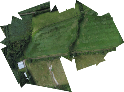
    Ortho-rectified stitch of photos from a flight over Crook castle, Waterford, showing lots of earthworks.

    crook.jpg


  • Moderators, Science, Health & Environment Moderators Posts: 5,220 Mod ✭✭✭✭slowburner


    Very cool.


  • Advertisement
  • Registered Users Posts: 316 ✭✭Simon.d


    slowburner wrote: »
    Very cool.

    Just loving playing with this software , brings a whole new dimension to low altitude aerial photographs..


  • Moderators, Science, Health & Environment Moderators Posts: 5,220 Mod ✭✭✭✭slowburner


    Could have done with your expertise today.
    A lengthy 'new' cursus in Carlow/Wexford has escaped all the usual imagery. It's as clear as a bell in the field, but it needs further surveying to piece together its situation in the broader landscape. The angle of sunlight today made photography futile from the ground.


  • Registered Users Posts: 316 ✭✭Simon.d


    slowburner wrote: »
    Could have done with your expertise today.
    A lengthy 'new' cursus in Carlow/Wexford has escaped all the usual imagery. It's as clear as a bell in the field, but it needs further surveying to piece together its situation in the broader landscape. The angle of sunlight today made photography futile from the ground.

    Would be very interested in giving it a go.. Though can't really guarantee anything.. Trying to get out on a Sunny day is in no way straightforward, especially when the site is a good hour away.. If the earthwork (assuming that's what it is) is linear it can be further complicated, as you'd need to pick a specific part of the day depending on the direction it runs (i.e. relatively perpendicular sun angle) and hope the sun is shining..


  • Moderators, Science, Health & Environment Moderators Posts: 5,220 Mod ✭✭✭✭slowburner


    Simon.d wrote: »
    Would be very interested in giving it a go.. Though can't really guarantee anything.. Trying to get out on a Sunny day is in no way straightforward, especially when the site is a good hour away.. If the earthwork (assuming that's what it is) is linear it can be further complicated, as you'd need to pick a specific part of the day depending on the direction it runs (i.e. relatively perpendicular sun angle) and hope the sun is shining..
    It's not an easy thing to capture, as you can probably see from this much adjusted image taken from across the ridge.
    I think summer sunlight would offer the best chance but then vegetation could obscure the view altogether.
    To crown it all, the wind is almost always going to be strong at this elevation.
    279382.JPG


  • Registered Users Posts: 316 ✭✭Simon.d


    Here's another one of the Woodstown Viking Site in Waterford.. Grass is going to seed in this shot showing some markings, but not much in terms of features that I can pick out, aside from some old field boundaries that were in situ on the old OSIs maps (Strong linears in right hand field).. Potentially some of the main ditch of the enclosure is discernible, but nothing very clear.. I'll be back for another look in the future..

    woodstown2.png


  • Registered Users Posts: 419 ✭✭bawn79


    slowburner wrote: »
    It's not an easy thing to capture, as you can probably see from this much adjusted image taken from across the ridge.
    I think summer sunlight would offer the best chance but then vegetation could obscure the view altogether.
    To crown it all, the wind is almost always going to be strong at this elevation.
    279382.JPG

    That's an amazing find slowburner - great stuff. I've never really kept much of an eye out for cursus when out and about.
    Just wondering - what is to say this isn't just the remains of a track over the hill from a much more recent period?


  • Moderators, Science, Health & Environment Moderators Posts: 5,220 Mod ✭✭✭✭slowburner


    bawn79 wrote: »
    That's an amazing find slowburner - great stuff. I've never really kept much of an eye out for cursus when out and about.
    Just wondering - what is to say this isn't just the remains of a track over the hill from a much more recent period?

    (Not my find by the way)

    Good question.
    There are four or five reasons.
    Firstly you would have to be doo-lally to construct a track straight up the steepest slope of the mountain - it's just far too difficult an ascent.
    Secondly, the area within the banks is at the same level as the ground outside. If it was lower, it would be reasonable to assume that the banks were the upcast from clearing the track. The banks are constructed of stone, as far as can be determined at the moment - the surrounding areas are turf.
    Thirdly, the banks are much too far apart at c. 33m. If anyone was making a track at this altitude and in the conditions commonly experienced on this mountain, you can be damn sure they would make it no wider than it needed to be.
    Fourth, the earthwork terminates at the summit and before it reaches the plain below. The terminus is the defining factor of a cursus monument.
    Most important of all is the cursus' situation. It sits on the side of Mount Leinster proclaiming its presence to all in the extensive plains unfurled beneath. I have no doubt that prehistoric folk were well aware of this symbolic earthwork as they approached the mountains from the west.
    It's a bit like the tattoo on the bicep of an enormous bouncer.

    The obvious questions are when it was constructed and for what?
    Cursus are generally thought to be neolithic. I like entertaining the idea that they date to the Bronze Age and that they proclaim the mineral rights of the Wicklow/Wexford/Carlow mountains.
    Other theories for the function of cursus include procession (of course) trials of fitness (hence the term) and stockades into which animals were herded and perhaps slaughtered.


  • Registered Users Posts: 983 ✭✭✭The Royal Scam


    slowburner wrote: »
    It's not an easy thing to capture, as you can probably see from this much adjusted image taken from across the ridge.
    I think summer sunlight would offer the best chance but then vegetation could obscure the view altogether.
    To crown it all, the wind is almost always going to be strong at this elevation.
    279382.JPG

    Is this near Mount Leinster. I have noticed this before.


  • Moderators, Science, Health & Environment Moderators Posts: 5,220 Mod ✭✭✭✭slowburner


    Is this near Mount Leinster. I have noticed this before.
    Indeed it is and known locally as 'the Witches' Slide'.


  • Registered Users Posts: 316 ✭✭Simon.d


    An interesting passage from a mid 19th century publication was brought to my attention today (R.H Rylands book on Waterford history).. Would love to hear opinions on it, whereby a passage way with a corbelled roof chamber was found in Waterford. The monument has been subsequently lost (or destroyed) and is listed as a Souterrain (WA017-103).

    Book
    "Near Whitfield were lately discovered two stone chambers somewhat resembling the monument at New Grange near Drogheda, described by Ledwich.
    On the removal of a vast heap of stones which lay of ages on the side of the road, and from which portions were taken away from time to time to be used in repairing, a large flag was observed, which, when removed, discovered a circular opening into an arched or vaulted apartment constructed in the shape of a bee-hive. It was composed of flat stones, the higher projecting beyond tthe lower, and tapered to a point which was convered by a flag. On entering into it, a narrow passage was discovered, leading from one side, but it was almost filled up with rubbish and clay: another chamber was found at no great distance. These buildings are about five or six feet high, and are supposed to have been used as tombs."


    A century earlier this passage was published in Smith's Book on Waterford history in relation to the same area (close to Whitfield house)

    Book
    yLgGfOU.jpg?1

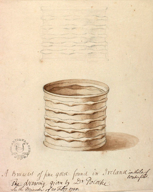
    Potentially this is the bracelet in question, as the pattern on the edge may be the "scolloping" referred to (no idea what is meant by scolloping!).. Though it seems a bit light for the £20 valuation in the mid 18th century.. With Isaac Newtowns Gold standard fixing Sterling (approx £4 per 30 grammes), it should be of the order of 150 grammes or so, not the 50g here....

    AN00738548_001_l.jpg?width=304


  • Advertisement
  • Moderators, Science, Health & Environment Moderators Posts: 5,220 Mod ✭✭✭✭slowburner


    Simon.d wrote: »
    An interesting passage from a mid 19th century publication was brought to my attention today (R.H Rylands book on Waterford history).. Would love to hear opinions on it, whereby a passage way with a corbelled roof chamber was found in Waterford. The monument has been subsequently lost (or destroyed) and is listed as a Souterrain (WA017-103).

    Book
    "Near Whitfield were lately discovered two stone chambers somewhat resembling the monument at New Grange near Drogheda, described by Ledwich.
    On the removal of a vast heap of stones which lay of ages on the side of the road, and from which portions were taken away from time to time to be used in repairing, a large flag was observed, which, when removed, discovered a circular opening into an arched or vaulted apartment constructed in the shape of a bee-hive. It was composed of flat stones, the higher projecting beyond tthe lower, and tapered to a point which was convered by a flag. On entering into it, a narrow passage was discovered, leading from one side, but it was almost filled up with rubbish and clay: another chamber was found at no great distance. These buildings are about five or six feet high, and are supposed to have been used as tombs."


    A century earlier this passage was published in Smith's Book on Waterford history in relation to the same area (close to Whitfield house)

    Book


    Potentially this is the bracelet in question, as the pattern on the edge may be the "scolloping" referred to (no idea what is meant by scolloping!).. Though it seems a bit light for the £20 valuation in the mid 18th century.. With Isaac Newtowns Gold standard fixing Sterling (approx £4 per 30 grammes), it should be of the order of 150 grammes or so, not the 50g here....
    'Location unknown' on the SMR.
    Sounds interesting although if stone was robbed out in the C18th, it's very likely nothing remains.
    A 'Danish fort' is more than likely a ring barrow although it could be a ringfort/enclosure.
    The location is about as vague as it could be: it's quite possible that the site is not actually in Whitfield Nth. townland. Searches like this can drive you mad but it looks to me like there is an interesting mound (?) half way up the fourth field from WA017-006 http://http://binged.it/1dow0Ds

    I think the scalloping refers to decoration on the rim of the funerary urn rather than the bracelet.


  • Registered Users Posts: 316 ✭✭Simon.d


    slowburner wrote: »
    'Location unknown' on the SMR.
    Sounds interesting although if stone was robbed out in the C18th, it's very likely nothing remains.
    A 'Danish fort' is more than likely a ring barrow although it could be a ringfort/enclosure.
    The location is about as vague as it could be: it's quite possible that the site is not actually in Whitfield Nth. townland. Searches like this can drive you mad but it looks to me like there is an interesting mound (?) half way up the fourth field from WA017-006 http://http://binged.it/1dow0Ds

    I think the scalloping refers to decoration on the rim of the funerary urn rather than the bracelet.
    I actually flew the plane over that spot before slowburner, as was hoping for some cropmarks in the field (on hunt for the site of Whitfield Castle which remains lost).. Must have a closer look at the photos..

    There was a very similar find in the 1890s in Knockeen (a closeby townland), detailed on page 230 of this Journal and listed as WA017-097002-.. Again two corbelled beehive chambers connected by a passage.. So maybe this was the same site mentioned by Ryland... And maybe the early 19th century interuption of the site is why one of the chambers was destroyed by 1890..


    I'm also thinking the the Danish Fort may have something to do with the Neighbouring townland of Dooneen (Little Fort), and listing WA017-116---- Again there's a grassy knoll there, where at one point a low bank apparently skirted around it's perimeter..

    Would the weight of the bracelet say anything about it's potential age? i.e. 150 grammes ?


  • Moderators, Science, Health & Environment Moderators Posts: 5,220 Mod ✭✭✭✭slowburner


    Simon.d wrote: »

    Would the weight of the bracelet say anything about it's potential age? i.e. 150 grammes ?
    I can't answer that for certain but I doubt that weight alone would be an indication of age. At a guess, later Bronze Age?


  • Registered Users Posts: 316 ✭✭Simon.d


    slowburner wrote: »
    I can't answer that for certain but I doubt that weight alone would be an indication of age. At a guess, later Bronze Age?

    Doing a bit more reading into it, and apparently it was lost, but there's a drawing somewhere..

    It's apparently a "Melfort Type Bracelet" that has "seamless pieces in gold" according to Cahill who compares it to the Lockington Bracelets Sown below, and views them as a potentially exotic import into early bronze age Ireland..

    ps289318_m.jpg

    Richard Pococke apparently found it (or took great interest in it) said it was found near Lisnakill Church in a Danish fort, and that it weighed 5 ounces..

    Got a feeling there may be an image of it in this paper if anyone has access: http://journals.cambridge.org/action/displayAbstract?fromPage=online&aid=2767036


    Edit:

    Another bit to the story giving a great description of the monument it was found under:


    uaJWUCr.png?1


  • Closed Accounts Posts: 24 Akhenaten


    Not sure if this is any use to you,but I came across an excerpt from 'Pococke's Tour in Ireland in 1752' relating to the bracelet found(see the link below):


    http://www.ucc.ie/celt/published/E750002-001.html

    "Near Lisnekil church in an ancient Danish fort were found two urns of Coarse earth, in one there was a black earth or Ashes, in the other a bracelet of pure gold, weighing about five ounces."


  • Registered Users Posts: 316 ✭✭Simon.d


    Thanks for that.. Was a very helpful bit of info, though came across it already..

    Pococke's luckily drew the thing..And it's now digitally archived in this great resource

    GtKuh2F.png


  • Closed Accounts Posts: 24 Akhenaten


    Simon.d wrote: »
    Thanks for that.. Was a very helpful bit of info, though came across it already..

    Pococke's luckily drew the thing..And it's now digitally archived in this great resource

    pa29-2.jpg

    Hi Simon.d,

    Yeah,I've only just read your earlier post with the same info.Sorry!:o


  • Moderators, Science, Health & Environment Moderators Posts: 5,220 Mod ✭✭✭✭slowburner


    Brilliant research Simon.d


  • Registered Users Posts: 316 ✭✭Simon.d


    slowburner wrote: »
    Brilliant research Simon.d

    Love a good challenge!

    How would I classify the burial type.. Seems there was a Stone Cairn on top of a Cist burial, and possibly a standing stone on top (though the handwritten text below doesn't specify this location) ..

    There seems to be a slight bit of variation in the detail between the two passages I've come across:

    dw7YOne.png

    uaJWUCr.png?1


  • Advertisement
  • Registered Users Posts: 419 ✭✭bawn79


    Simon.d wrote: »
    How would I classify the burial type.. Seems there was a Stone Cairn on top of a Cist burial, and possibly a standing stone on top (though the handwritten text below doesn't specify this location) ..

    Great stuff Simon- where did this description come from?

    Unfortunately in my opinion a souterain could look a lot like a passage tomb.

    Souterains are also especially located near Lios's.


Advertisement