Advertisement
If you have a new account but are having problems posting or verifying your account, please email us on hello@boards.ie for help. Thanks :)
Hello all! Please ensure that you are posting a new thread or question in the appropriate forum. The Feedback forum is overwhelmed with questions that are having to be moved elsewhere. If you need help to verify your account contact hello@boards.ie

The Curiosity On Mars Thread.

Options
1161719212245

Comments

  • Closed Accounts Posts: 4,029 ✭✭✭shedweller


    More Meters in Curiosity's Rearview Mirror

    Mon, 17 Sep 2012 09:34:13 PM GMT

    Sol 39 through 41 (Sept. 14 – 17) were driving days for the Curiosity rover. On Sol 39, Curiosity logged 72 feet (22 meters) driven. On Sol 40, the rover drove another 121 feet (37 meters). On Sol 41, Curiosity logged 89 feet (27 meters), across the surface of Gale Crater. During this sol, for the first time, the DAN instrument (the Dynamic Albedo of Neutrons investigation) was incorporated into the rover's drive sequence. In its active mode, DAN can detect minerals associated with water below the surface. Along Curiosity’s path, DAN shoots neutrons into the ground and measures how they scatter. The instrument has a high sensitivity for finding any hydrogen to a depth of about 20 inches (50 centimeters) directly beneath the rover. After driving 33 feet (10 meters), the rover stops and the DAN instrument operates for two minutes. Then another 10 meters, then another DAN measurement.

    Total distance racked up by Curiosity since landing on Mars on Aug. 5 is 745 feet (227 meters).

    An image of the surface of Gale Crater, taken on Sol 41 by the rover's left navigation camera, is available at: http://1.usa.gov/OAG8Rv .

    Curiosity continues to be in good health. Sol 41, in Mars local mean solar time at Gale Crater, ended at 10:33 a.m. Sept. 17, PDT.
    http://www.nasa.gov/mission_pages/msl/index.html

    NLA_401232925EDR_F0041632NCAM00427M_.JPG


  • Closed Accounts Posts: 4,029 ✭✭✭shedweller


    PASADENA, Calif. -- NASA will host a media teleconference at 11 a.m. PDT (2 p.m. EDT) tomorrow (Wednesday, Sept. 19), to provide a status update on the Curiosity rover's mission to Mars' Gale Crater. Curiosity, the Mars Science Laboratory, is 43 days into a two-year mission to investigate whether conditions may have been favorable for microbial life.
    Audio and visuals from the telecon will be streamed live to one of JPL's Ustream.tv channels, at www.ustream.tv/nasajpl .
    Visuals only will be available at the start of the telecon at: http://go.nasa.gov/curiositytelecon .
    For more information about NASA's Curiosity mission, visit: http://www.nasa.gov/msl and http://mars.jpl.nasa.gov/msl .


    That's 19:00 GMT if anyones got some free time. I'll be busy putting the kids to bed..........;)

    And for those of you, like me, that struggle with world times:
    http://www.worldtimebuddy.com/edt-to-gmt-converter


  • Registered Users Posts: 1,506 ✭✭✭shizz


    shedweller wrote: »
    PASADENA, Calif. -- NASA will host a media teleconference at 11 a.m. PDT (2 p.m. EDT) tomorrow (Wednesday, Sept. 19), to provide a status update on the Curiosity rover's mission to Mars' Gale Crater. Curiosity, the Mars Science Laboratory, is 43 days into a two-year mission to investigate whether conditions may have been favorable for microbial life.
    Audio and visuals from the telecon will be streamed live to one of JPL's Ustream.tv channels, at www.ustream.tv/nasajpl .
    Visuals only will be available at the start of the telecon at: http://go.nasa.gov/curiositytelecon .
    For more information about NASA's Curiosity mission, visit: http://www.nasa.gov/msl and http://mars.jpl.nasa.gov/msl .


    That's 19:00 GMT if anyones got some free time. I'll be busy putting the kids to bed..........;)

    And for those of you, like me, that struggle with world times:
    http://www.worldtimebuddy.com/edt-to-gmt-converter

    That's the right time but we're GMT +1 just in case anyone gets confused. It would be 18:00 GMT


  • Closed Accounts Posts: 4,029 ✭✭✭shedweller


    That'll be me failing spectacularly there then!!


  • Closed Accounts Posts: 4,029 ✭✭✭shedweller


    09.19.2012
    'Jake Matijevic' Contact Target for Curiosity
    The drive by NASA's Mars rover Curiosity during the mission's 43rd Martian day, or sol, (Sept. 19, 2012) ended with this rock about 8 feet (2.5 meters) in front of the rover. The rock is about 10 inches (25 centimeters) tall and 16 inches (40 centimeters) wide. The rover team has assessed it as a suitable target for the first use of Curiosity's contact instruments on a rock. The image was taken by the left Navigation camera (Navcam) at the end of the drive.

    The rock has been named "Jake Matijevic." This commemorates Jacob Matijevic (1947-2012), who was the surface operations systems chief engineer for the Mars Science Laboratory Project and the project's Curiosity rover. He was also a leading engineer for all of the previous NASA Mars rovers: Sojourner, Spirit and Opportunity.

    Curiosity's contact instruments are on a turret at the end of the rover's arm. They are the Alpha Particle X-Ray Spectrometer for reading a target's elemental composition and the Mars Hand Lens Imager for close-up imaging.

    Image Credit: NASA/JPL-Caltech
    http://marsmobile.jpl.nasa.gov/msl/images/Grotzinger-1_5-pia16155-br2.jpg


  • Advertisement
  • Registered Users Posts: 1,073 ✭✭✭littlemac1980


    That's a very interesting looking rock.

    I do wonder about the distribution of rocks generally on the surface of mars. There seem to be very few significantly large rocks around. Why is this?

    Is it generally believed that all the rocks and stones on the surface are where they are as a result of volcanic eruptions, if so, should there not be all manner of sizes of rocks.

    Also almost all the rocks (with the exception of jakey there - what a silly name for a rock! :rolleyes:) are quite sharp edged. Is it possible that even with the thin atmosphere that all those rocks and stones have sat there for millions of years, and not been eroded a lot more?

    There seems to be quite a lot of dust around, and there are pictures of significant dust devils. Also the landscape around the base of Mt. Sharp is clearly very heavily eroded.

    I presume the shape of Jake is attributable to some process of extreme heating of the rock, perhaps from entry to the atmosphere, or being ejected from a deeper part with a volcano.

    Maybe its just me, and I'm not suggesting for a second that the pictures are fake (I'm not going down that direction)... but I've studied a lot of the high res images of Mars, such as the rim-less holes, and the strange sequential linear crater features, and the spider features at the south pole, and many of the other pictures the rovers have sent back.

    I keep getting a niggling feeling that there is something significant about the history of the planet that could be figured out without zapping rocks, i.e. from simple observation of the high res images from the orbiters.

    Don't think for a second that I mean curiosity is a waste of time. I think its the most exciting purely scientific thing that has happened in my lifetime, well certain other space missions are up their with it too. I can't wait for Dawn to reach Ceres!


  • Registered Users Posts: 325 ✭✭ThatDrGuy


    Could be a fun interpretation of anthropic priciple... Big boulder field is too dangerous to land/manouvre billion dollar rovers so landing sites are chosen to be flat.


  • Closed Accounts Posts: 4,029 ✭✭✭shedweller


    Littlemac,

    I remember there being talk about the shapes of mars rocks. The wind has indeed shaped them but the atmosphere is extremely thin so it carries a lot less energy and therefore much lighter particles. I think the discussion i saw had comparisons here on Earth with rocks in antartica featured.
    The sharp edges were, i think, due to erosion. But from one direction most of the time, which means sharp edges. Not like here where the wind is shifting around a lot and therefore averaging out the wear.
    I think i'm close enough to the mark there.........(does a quick google session...)


  • Registered Users Posts: 18,299 ✭✭✭✭namloc1980


    That's a very interesting looking rock.

    I do wonder about the distribution of rocks generally on the surface of mars. There seem to be very few significantly large rocks around. Why is this?

    Viking 1, Viking 2 and Pathfinder all landed in very rocky locations:

    Viking 1:
    7220649616_bcbba181bc_z.jpg

    Viking 2
    First_Color_Image_of_the_Viking_Lander_2_Site.jpg

    Pathfinder:
    5199347431_ae463ae72f_z.jpg


  • Closed Accounts Posts: 4,029 ✭✭✭shedweller


    Near Target Rock 'Matijevic'

    Thu, 20 Sep 2012 07:15:37 PM GMT

    In a day of abbreviated activities due to timing of downlink relays, Curiosity used cameras on Sol 44 (Sept. 20) to observe early-morning atmospheric conditions, inspect a nearby rock, and image rover hardware.

    The rover team has decided to edge Curiosity closer to a nearby rock called Jake Matijevic, which is likely to become the first that the rover will touch with instruments on its robotic arm. Jacob Matijevic (1947-2012) was a leading engineer for all three generations of NASA Mars rovers.

    The arm was deployed on Sol 44 to take some images of rover hardware and to assess the extended arm's sag.:eek: A raw image from the Navigation Camera shows the arm's shadow on the ground near the Jake Matijevic rock. The image is at http://1.usa.gov/PDAjzm . The arm was subsequently re-stowed in preparation for a short drive to approach the rock.

    Curiosity continues to work in good health. Sol 44, in Mars local mean solar time at Gale Crater, ends at 12:31 p.m. Sept. 20, PDT.
    http://www.nasa.gov/mission_pages/msl/index.html
    689468main_pia16155-43_946-710.jpg
    Sag?? Ok, i'm guessing this is no more than expected and they just need to confirm their expectations??
    It's titanium tubing too, so some sag is probably nothing to worry about. It's the gears in the joints i'd be worried about. Although if they are like normal robot gearboxes (epicyclical) then we have nothing to worry about. Where i work we have quite a few and i have never replaced any!:D
    Anyway, aerial view showing the progress to date. Halfway to Glenelg already. Where does the time go??!
    689478main_pia16153b-43_800-600.jpg


  • Advertisement
  • Closed Accounts Posts: 4,029 ✭✭✭shedweller


    http://www.nasa.gov/mission_pages/msl/multimedia/gallery-indexEvents.html


    On the Road to Glenelg

    This mosaic from the Mast Camera on NASA's Curiosity rover shows the view looking toward the "Glenelg" area, where three different terrain types come together. All three types are observed from orbit with the High-Resolution Imaging Science Experiment (HiRISE) camera on NASA's Mars Reconnaissance Orbiter. By driving there, Curiosity will be able to explore them.

    One of the three terrain types is light-toned with well-developed layering, which likely records deposits of sedimentary materials. There are also black bands that run through the area and might constitute additional layers that alternate with the light-toned layers. The black bands are not easily seen from orbit and are on the order of about 3.3-feet (1-meter) thick. Both of these layer types are important science targets.

    This mosaic is composed of seven images. The Mastcam 34-millimeter camera took a series of four images; embedded within that series is a second set of three images taken with the Mastcam 100-millimeter camera.

    Image credit: NASA/JPL-Caltech/MSSS
    689425main_pia16154-43_800-600.jpg


  • Closed Accounts Posts: 4,029 ✭✭✭shedweller


  • Closed Accounts Posts: 4,029 ✭✭✭shedweller


    548207_412130908836890_532182771_n.jpg

    I don't have any information on what went on here so we'll just have to wait!

    edit I think it's MAHLI that's pointing at the rock.
    Here's a pic of the head:684450main_Robinson-3-pia16145-43_946-710.jpg


  • Closed Accounts Posts: 4,029 ✭✭✭shedweller


    And look what i found, while digging:
    cr5.jpg


  • Registered Users Posts: 456 ✭✭ceejay


    shedweller wrote: »
    548207_412130908836890_532182771_n.jpg

    I don't have any information on what went on here so we'll just have to wait!

    edit I think it's MAHLI that's pointing at the rock.
    Here's a pic of the head:684450main_Robinson-3-pia16145-43_946-710.jpg

    I think it's APXS pointing at the rock - you can clearly see the drill pointing to the right.

    Sorry, it is MAHLI - I didn't realise the schematic of the head was showing the view from below the head as seen in the picture :o


  • Closed Accounts Posts: 4,029 ✭✭✭shedweller


    Yes, that did take a bit of mental reversing to figure it out!


  • Closed Accounts Posts: 4,029 ✭✭✭shedweller


    First pics from MAHLI:

    691086main_pia16221-43_800-600.jpg
    Mars Hand Lens Imager Nested Close-Ups of Rock 'Jake Matijevic'

    This image combines photographs taken by the Mars Hand Lens Imager (MAHLI) at three different distances from the first Martian rock that NASA's Curiosity rover touched with its arm. The three exposures were taken during the 47th Martian day, or sol, of Curiosity's work on Mars (Sept. 23, 2012). The team has named the target rock "Jake Matijevic." The scale bar is 4 centimeters (1.6 inches).

    MAHLI imaged Jake Matijevic from distances of about 10 inches, or 25 centimeters (context image); about 2 inches, or 5 centimeters (larger white box); and about 1 inch, or 2.5 centimeters (smaller white box). The series nested into this one image takes advantage of MAHLI's adjustable focus.

    MAHLI reveals that the target rock has a relatively smooth, gray surface with some glinty facets reflecting sunlight and reddish dust collecting in recesses in the rock.

    Jake Matijevic is a dark, apparently uniform rock that was selected as a desirable target because it allowed the science team to compare results of the Alpha Particle X-Ray Spectrometer (APXS) instrument and the Chemistry and Camera (ChemCam) instrument, both of which provide information about the chemical elements in a target. APXS, like MAHLI, is on the turret at the end of Curiosity's robotic arm. It is placed in contact with a rock to take a reading. ChemCam shoots laser pulses at a target from the top of the rover's mast.

    Jake Matijevic was also the first rock target for MAHLI, which was deployed to document the APXS and ChemCam analysis areas.

    Image credit: NASA/JPL-Caltech/MSSS


  • Closed Accounts Posts: 4,029 ✭✭✭shedweller


    Do the engineers listen to this groovy music as they drive the rover?:D

    Ceejay, this animation has APXS doing the work so maybe they did use it after all!


  • Closed Accounts Posts: 4,029 ✭✭✭shedweller


    Remnants of Ancient Streambed on Mars (Closeup)
    NASA's Curiosity rover found evidence for an ancient, flowing stream on Mars at a few sites, including the rock outcrop pictured here, which the science team has named "Hottah" after Hottah Lake in Canada's Northwest Territories. It may look like a broken sidewalk, but this geological feature on Mars is actually exposed bedrock made up of smaller fragments cemented together, or what geologists call a sedimentary conglomerate. Scientists theorize that the bedrock was disrupted in the past, giving it the titled angle, most likely via impacts from meteorites.

    The key evidence for the ancient stream comes from the size and rounded shape of the gravel in and around the bedrock. Hottah has pieces of gravel embedded in it, called clasts, up to a couple inches (few centimeters) in size and located within a matrix of sand-sized material. Some of the clasts are round in shape, leading the science team to conclude they were transported by a vigorous flow of water. The grains are too large to have been moved by wind.

    Broken surfaces of the outcrop have rounded, gravel clasts, such as the one circled in white, which is about 1.2 inches (3 centimeters) across. Erosion of the outcrop results in gravel clasts that protrude from the outcrop and ultimately fall onto the ground, creating the gravel pile at left.

    This image mosaic was taken by Curiosity's 100-millimeter Mastcam telephoto lens on its 39th Martian day, or sol, of the mission (Sept. 14, 2012 PDT/Sept. 15 GMT).

    Image Credit: NASA/JPL-Caltech/MSSS


    692146main_Williams-2pia16188-43_800-600.jpg
    Link to a Watery Past

    In this image from NASA's Curiosity rover, a rock outcrop called Link pops out from a Martian surface that is elsewhere blanketed by reddish-brown dust. The fractured Link outcrop has blocks of exposed, clean surfaces. Rounded gravel fragments, or clasts, up to a couple inches (few centimeters) in size are in a matrix of white material. Many gravel-sized rocks have eroded out of the outcrop onto the surface, particularly in the left portion of the frame. The outcrop characteristics are consistent with a sedimentary conglomerate, or a rock that was formed by the deposition of water and is composed of many smaller rounded rocks cemented together. Water transport is the only process capable of producing the rounded shape of clasts of this size.

    The Link outcrop was imaged with the 100-millimeter Mast Camera on Sept. 2, 2012, which was the 27th sol, or Martian day of operations.

    The name Link is derived from a significant rock formation in the Northwest Territories of Canada, where there is also a lake with the same name.

    Scientists enhanced the color in this version to show the Martian scene as it would appear under the lighting conditions we have on Earth, which helps in analyzing the terrain.

    Image credit: NASA/JPL-Caltech/MSSS


    So when they say "water" do they actually mean H2O?!! What kind of timeline are we talking about here, in relation to when this water flowed?


  • Registered Users Posts: 2,960 ✭✭✭IrishHomer


    shedweller wrote: »
    Remnants of Ancient Streambed on Mars (Closeup)
    NASA's Curiosity rover found evidence for an ancient, flowing stream on Mars at a few sites, including the rock outcrop pictured here, which the science team has named "Hottah" after Hottah Lake in Canada's Northwest Territories. It may look like a broken sidewalk, but this geological feature on Mars is actually exposed bedrock made up of smaller fragments cemented together, or what geologists call a sedimentary conglomerate. Scientists theorize that the bedrock was disrupted in the past, giving it the titled angle, most likely via impacts from meteorites.

    The key evidence for the ancient stream comes from the size and rounded shape of the gravel in and around the bedrock. Hottah has pieces of gravel embedded in it, called clasts, up to a couple inches (few centimeters) in size and located within a matrix of sand-sized material. Some of the clasts are round in shape, leading the science team to conclude they were transported by a vigorous flow of water. The grains are too large to have been moved by wind.

    Broken surfaces of the outcrop have rounded, gravel clasts, such as the one circled in white, which is about 1.2 inches (3 centimeters) across. Erosion of the outcrop results in gravel clasts that protrude from the outcrop and ultimately fall onto the ground, creating the gravel pile at left.

    This image mosaic was taken by Curiosity's 100-millimeter Mastcam telephoto lens on its 39th Martian day, or sol, of the mission (Sept. 14, 2012 PDT/Sept. 15 GMT).

    Image Credit: NASA/JPL-Caltech/MSSS


    692146main_Williams-2pia16188-43_800-600.jpg
    Link to a Watery Past

    In this image from NASA's Curiosity rover, a rock outcrop called Link pops out from a Martian surface that is elsewhere blanketed by reddish-brown dust. The fractured Link outcrop has blocks of exposed, clean surfaces. Rounded gravel fragments, or clasts, up to a couple inches (few centimeters) in size are in a matrix of white material. Many gravel-sized rocks have eroded out of the outcrop onto the surface, particularly in the left portion of the frame. The outcrop characteristics are consistent with a sedimentary conglomerate, or a rock that was formed by the deposition of water and is composed of many smaller rounded rocks cemented together. Water transport is the only process capable of producing the rounded shape of clasts of this size.

    The Link outcrop was imaged with the 100-millimeter Mast Camera on Sept. 2, 2012, which was the 27th sol, or Martian day of operations.

    The name Link is derived from a significant rock formation in the Northwest Territories of Canada, where there is also a lake with the same name.

    Scientists enhanced the color in this version to show the Martian scene as it would appear under the lighting conditions we have on Earth, which helps in analyzing the terrain.

    Image credit: NASA/JPL-Caltech/MSSS


    So when they say "water" do they actually mean H2O?!! What kind of timeline are we talking about here, in relation to when this water flowed?

    This story is on the main Sky News headlines tonight! :-)


  • Advertisement
  • Moderators, Social & Fun Moderators Posts: 12,765 Mod ✭✭✭✭JupiterKid


    shedweller wrote: »
    Remnants of Ancient Streambed on Mars (Closeup)
    NASA's Curiosity rover found evidence for an ancient, flowing stream on Mars at a few sites, including the rock outcrop pictured here, which the science team has named "Hottah" after Hottah Lake in Canada's Northwest Territories. It may look like a broken sidewalk, but this geological feature on Mars is actually exposed bedrock made up of smaller fragments cemented together, or what geologists call a sedimentary conglomerate. Scientists theorize that the bedrock was disrupted in the past, giving it the titled angle, most likely via impacts from meteorites.

    The key evidence for the ancient stream comes from the size and rounded shape of the gravel in and around the bedrock. Hottah has pieces of gravel embedded in it, called clasts, up to a couple inches (few centimeters) in size and located within a matrix of sand-sized material. Some of the clasts are round in shape, leading the science team to conclude they were transported by a vigorous flow of water. The grains are too large to have been moved by wind.

    Broken surfaces of the outcrop have rounded, gravel clasts, such as the one circled in white, which is about 1.2 inches (3 centimeters) across. Erosion of the outcrop results in gravel clasts that protrude from the outcrop and ultimately fall onto the ground, creating the gravel pile at left.

    This image mosaic was taken by Curiosity's 100-millimeter Mastcam telephoto lens on its 39th Martian day, or sol, of the mission (Sept. 14, 2012 PDT/Sept. 15 GMT).

    Image Credit: NASA/JPL-Caltech/MSSS


    692146main_Williams-2pia16188-43_800-600.jpg


    So when they say "water" do they actually mean H2O?!! What kind of timeline are we talking about here, in relation to when this water flowed?


    So I was right when I thought that this rock was a sedimentary conglomerate.:)

    Conglomerates have of course been found on Mars before - Pathfinder had conglomerates at its Area valles landing site in 1997,


  • Registered Users Posts: 18,299 ✭✭✭✭namloc1980


    20120925_phobos_msl_daytime_0045MR0209002000E1_DXXX_cleaned.jpg

    Spot the crescent Phobos in the Martian sky!!


  • Registered Users Posts: 18,299 ✭✭✭✭namloc1980


    Deimos transit of the Sun.

    index.php?act=attach&type=post&id=28343


  • Closed Accounts Posts: 4,029 ✭✭✭shedweller


    Not quite a Deimos Transit but Curiosity spent some time at "Bathurst Inlet" during Sol 54.
    693125main_pia14762-946.jpg
    'Bathurst Inlet' Rock on Curiosity's Sol 54, Context View

    NASA's Mars rover Curiosity held its Mars Hand Lens Imager (MAHLI) camera about 10.5 inches (27 centimeters) away from the top of a rock called "Bathurst Inlet" for a set of eight images combined into this merged-focus view of the rock. This context image covers an area roughly 6.5 inches by 5 inches (16 centimeters by 12 centimeters). Resolution is about 105 microns per pixel.

    MAHLI took the component images for this merged-focus view, plus closer-up images of Bathurst Inlet, during Curiosity's 54th Martian day, or sol (Sept. 30, 2012). The instrument's principal investigator had invited Curiosity's science team to "MAHLI it up!" in the selection of Sol 54 targets for inspection with MAHLI and with the other instrument at the end of Curiosity's arm, the Alpha Particle X-Ray Spectrometer.

    A merged-focus MAHLI view from closer to the rock, providing even finer resolution, is at http://photojournal.jpl.nasa.gov/catalog/14763 .

    The Bathurst Inlet rock is dark gray and appears to be so fine-grained that MAHLI cannot resolve grains or crystals in it. This means that the grains or crystals, if there are any at all, are smaller than about 80 microns in size. Some windblown sand-sized grains or dust aggregates have accumulated on the surface of the rock but this surface is clean compared to, for example, the pebbly substrate below the rock (upper left and lower right in this context image).

    MAHLI can do focus merging onboard. The full-frame versions of the eight separate images that were combined into this view were not even returned to Earth -- just the thumbnail versions. Merging the images onboard reduces the volume of data that needs to be downlinked to Earth.

    Image credit: NASA/JPL-Caltech/Malin Space Science Systems


    Merged onboard you say! Fancy!:)


  • Registered Users Posts: 456 ✭✭ceejay


    Resolution is about 105 microns per pixel.

    :eek:


  • Closed Accounts Posts: 4,029 ✭✭✭shedweller


    Or 0.01mm. Thats pretty good for a robot that navigated its way to mars, landed, drove, is a dab hand at photography (including photoshop techniques like layers!!)


  • Closed Accounts Posts: 4,029 ✭✭✭shedweller


    Approach to Ripple

    Wed, 03 Oct 2012 11:03:08 PM GMT
    On Sol 56 (Oct. 2, 2012), Curiosity drove about 20 feet (6 meters) westward to reach a ripple of sand and dust deposited by the wind at a soil patch called "Rocknest." This site is a potential target for the rover's first use of its scoop, which the team will be evaluating over the next few days.

    Activities on Sol 56 also included monitoring the environment around Curiosity with the Radiation Assessment Detector (RAD), the Dynamic Albedo of Neutrons (DAN) instrument, and the Rover Environmental Monitoring Station (REMS). A raw image from Curiosity's front Hazard Avoidance Camera (Hazcam) after the Sol 56 drive, showing a ripple at Rocknest, is at http://1.usa.gov/PstZsE .

    Sol 56, in Mars local mean solar time at Gale Crater, ended at 8:26 p.m. Oct. 2, PDT (11:26 p.m. EDT).
    NLA_402563129EDR_F0050000NCAM00446M_.JPG

    I'm guessing the rover detected a sudden "something" happen and stopped. Hence the pic of the sand dune.


  • Closed Accounts Posts: 4,029 ✭✭✭shedweller


    First Scoopful a Success
    Mon, 08 Oct 2012 03:52:13 PM GMT

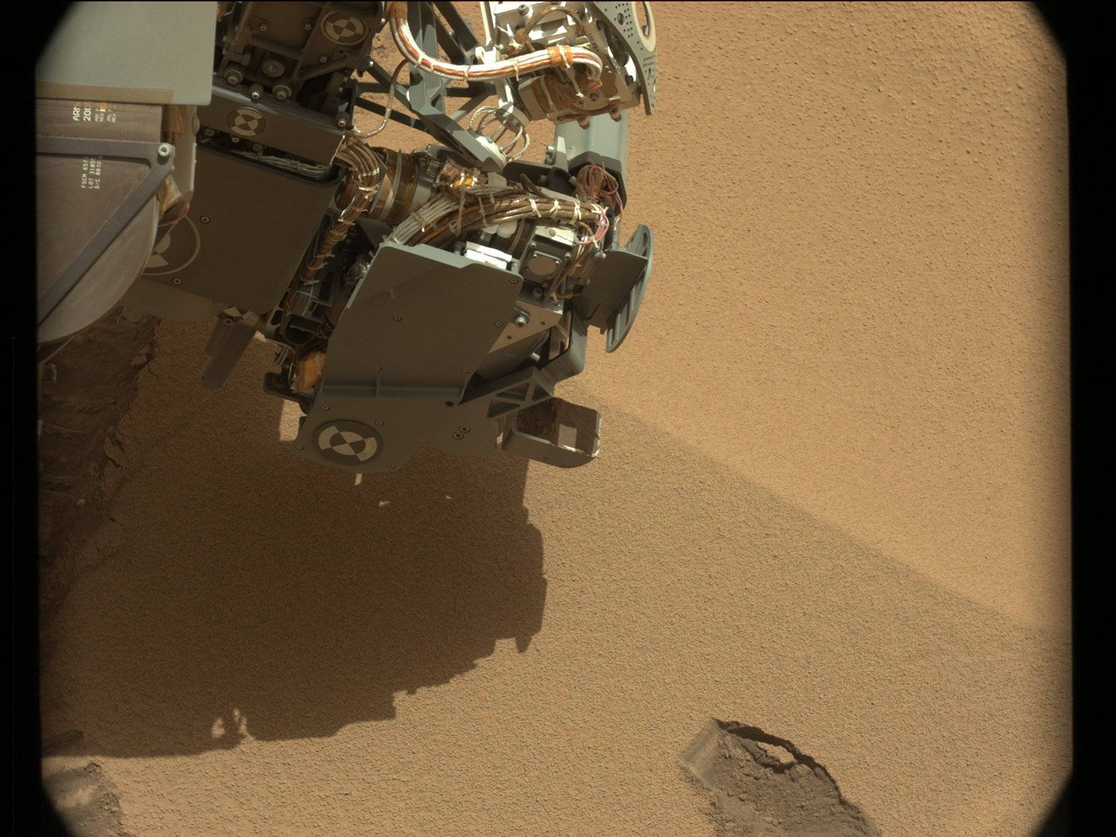
    On the mission's 61st Martian day, or sol (Oct. 7, 2012), NASA's Mars rover Curiosity used its soil scoop for the first time, collecting a scoopful of sand and powdery material at the "Rocknest" site. Imaging verified collection of the sample. The collected material will be used for cleaning interior surfaces of the rover's sample-handling mechanism. It will be held and vibrated inside each chamber of the mechanism before the material is discarded. Curiosity's Collection and Handling for In-Situ Martian Rock Analysis (CHIMRA) device, on the robotic arm, includes the scoop and the mechanism for sieving and portioning samples of soil and powdered rock.
    A Sol 61 raw image from Curiosity's left navigation camera, at http://1.usa.gov/OMDbxy , shows where the soil collected by the scoop was removed from the ground. The scoop leaves a hole 1.8 inches (4.5 centimeters) wide.

    The rover's ability to put scooped and sieved samples of soil into onboard laboratory instruments is an important part of the mission. Those instruments -- Chemistry and Mineralogy (CheMin) and Sample Analysis at Mars (SAM) -- will play crucial roles in evaluating whether the study area has ever had a favorable environment for microbial life. Still to be used for the first time is the rover's capability to take powdered samples from rocks, using a percussive drill, for delivery to those same instruments.

    Sol 61, in Mars local mean solar time at Gale Crater, ended at11:44 p.m. Oct. 7, PDT (2:44 a.m. Oct. 8, EDT).
    0061ML0301000000E1_DXXX.jpg
    NRA_402905750EDR_F0050104NCAM00325M_.JPG


  • Registered Users Posts: 6,700 ✭✭✭Mountainsandh


    that sand looks wet :D


    What ?
    I'm allowed say it, I'm just a curious amateur, not like you experts :P


  • Advertisement
Advertisement