Advertisement
If you have a new account but are having problems posting or verifying your account, please email us on hello@boards.ie for help. Thanks :)
Hello all! Please ensure that you are posting a new thread or question in the appropriate forum. The Feedback forum is overwhelmed with questions that are having to be moved elsewhere. If you need help to verify your account contact hello@boards.ie

Your opinions - possible wedge tomb?

  • 14-09-2012 11:08am
    #1
    Moderators, Science, Health & Environment Moderators Posts: 5,221 Mod ✭✭✭✭


    Posted on this somewhere else (I think).
    This alignment of heavy slabs is in the Wicklow uplands.
    Is it a natural formation caused by tree fall like this?

    220648.jpg

    The orientation ticks the box (broadly E/W - 240º to be precise) - this could be a consequence of prevailing wind direction, tree fall, and uprooted slabs. The plantation floor is littered with similar slabs.
    There is no sign of a septal slab.

    220649.jpg

    Not visible in the picture above is evidence of excavation in the floor of the alignment (not recent). It is between the megaliths on the right, and behind the trunk in the foreground.
    Why or when this dig occurred, I do not know, but wasn't there an old Irish tradition of flattening the floor, and offering milk to the deities in places like this?

    It's difficult to determine if the indentations in the picture below are natural or not. If man made, what purpose might they have served?
    I should mention that mining has a long history in the district, although this particular feature is outside the mineral rich zone.
    The association between copper exploitation and wedge tombs, might weigh in here.
    Within an area of around 7-800m, there are remains of various, small scale 'trial' workings, and a possible early (tbc) adit. It is likely that red ochre was exploited close by in the C.17th, and possible medieval iron exploitation.
    All in all, a busy, and interesting place!


    220650.jpg


Comments

  • Registered Users Posts: 128 ✭✭olly_mac


    This reminds me of a similar site I reported to the relavent authority (Dúchas back then), a number of years back. The site in question was on the Dublin side of the mountains. I never followed it up however.

    Did you get overall dimensions? Can be handy in doing a morphology...


  • Closed Accounts Posts: 1,541 ✭✭✭Gee Bag


    Are there any other slabs/stones of similar size visible in the surrounding area?


  • Moderators, Science, Health & Environment Moderators Posts: 5,221 Mod ✭✭✭✭slowburner


    olly_mac wrote: »
    This reminds me of a similar site I reported to the relavent authority (Dúchas back then), a number of years back. The site in question was on the Dublin side of the mountains. I never followed it up however.

    Did you get overall dimensions? Can be handy in doing a morphology...
    Here's an embarrassingly bad plan.

    biG5r.jpg


  • Moderators, Science, Health & Environment Moderators Posts: 5,221 Mod ✭✭✭✭slowburner


    Gee Bag wrote: »
    Are there any other slabs/stones of similar size visible in the surrounding area?
    It's difficult to see it in this pic, but underneath this massive slab has almost certainly been dug out, and I reckon the spoil is too far from the slab for it to have been the work of an animal.
    It's about 10 m from the alignment, and is part of a cluster of similar slabs.

    i2nBIl.jpg

    This photo shows more of the context.
    The area is strewn with boulders predominantly, these are granite erratics. Outside the cluster of large slabs the area is littered with smaller slabs (possibly chalcopyrite).
    It is possible that some of these slabs may have been broken out from the bed rock as trials for metal ore - at some unknown period, but almost certainly pre C.18th

    Jl4Aol.jpg

    This photo shows the remains of an early wall, about 10m from the alignment. The wall is not shown on the first ed. map.

    VYG4rl.jpg

    First ed. view with the crosshairs, more or less on the alignment.

    3JG35l.png

    When the site was first visited by an eminent archaeologist, he said "This place reeks of prehistory."
    He would not commit to a verdict on the alignment though, and hasn't mentioned it since.
    Two other senior archies give odds of about 60/40 in favour of it not being natural.

    Another point to consider is that this copse is one of a number in intensively cultivated land.
    All of the other copses contain anomalies of some kind or other, such as forgotten mine workings etc. (one copse encloses a national monument).
    It's possible the area hasn't been cultivated because of the alignment.
    The copse today, broadly fits into the area defined by the two trackways in the image above.


  • Registered Users Posts: 128 ✭✭olly_mac


    A bad plan is better than no plan :)

    It looks like wedge to my untrained eye....


  • Advertisement
  • Registered Users, Registered Users 2 Posts: 316 ✭✭Simon.d


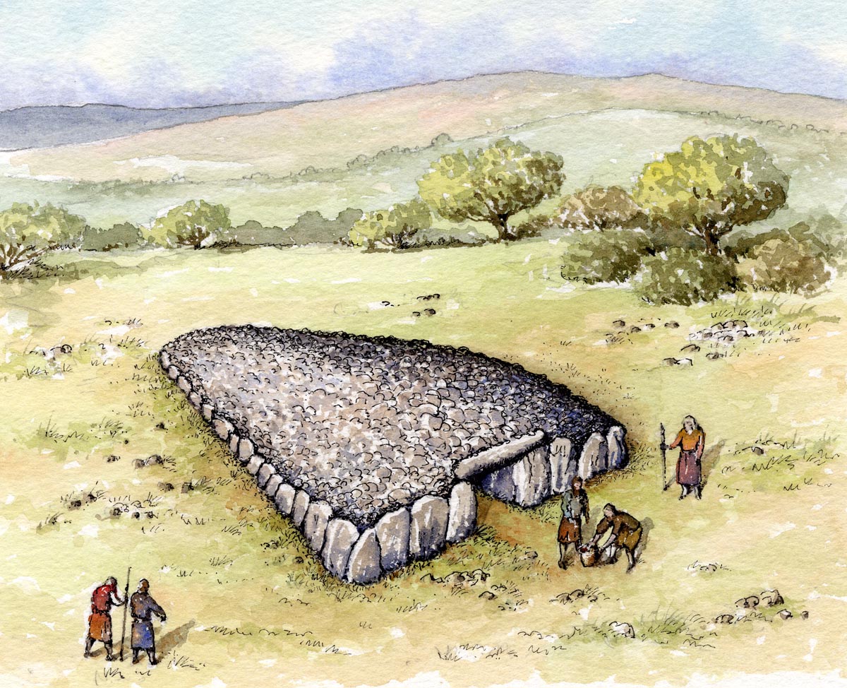
    Not much to add in terms of identifying what the site may be... But found this nice Wedge tomb Reconstruction (from http://www.philarm.com/):


    wedge_tomb.jpg


  • Closed Accounts Posts: 1,541 ✭✭✭Gee Bag


    slowburner wrote: »
    Here's an embarrassingly bad plan.

    biG5r.jpg

    Nothing at all wrong with that sketch map Slowburner. Shows the layout of the site perfectly. It's almost impossible to take good photo's in a heavily forested area. If you have brought up a few archies and they think the site looks genuine then maybe you should consider filling out a monument report form..........

    http://www.archaeology.ie/media/archeologyie/PDFS/ASI%20Monument%20Report%20Form%20%20(June%202012).pdf

    Someone in the ASI will get around to having a look at it and it might be added to the RMP.


  • Registered Users, Registered Users 2 Posts: 419 ✭✭bawn79


    Cool didnt realise there was an actual form for reporting monuments. Looks very promising.


  • Moderators, Science, Health & Environment Moderators Posts: 5,221 Mod ✭✭✭✭slowburner


    Gee Bag wrote: »
    slowburner wrote: »
    Here's an embarrassingly bad plan.

    biG5r.jpg

    Nothing at all wrong with that sketch map Slowburner. Shows the layout of the site perfectly. It's almost impossible to take good photo's in a heavily forested area. If you have brought up a few archies and they think the site looks genuine then maybe you should consider filling out a monument report form..........

    http://www.archaeology.ie/media/archeologyie/PDFS/ASI%20Monument%20Report%20Form%20%20(June%202012).pdf

    Someone in the ASI will get around to having a look at it and it might be added to the RMP.

    I have one of those forms, but I'd prefer to get confirmation before submitting it, and getting confirmation is bit of a challenge.
    I'm told the absolute authority on these things retired just after he was given the location.


  • Closed Accounts Posts: 1,541 ✭✭✭Gee Bag


    slowburner wrote: »
    I have one of those forms, but I'd prefer to get confirmation before submitting it, and getting confirmation is bit of a challenge.
    I'm told the absolute authority on these things retired just after he was given the location.

    From the sketch map and the size of the slabs I'd reckon your off to a good start. You also said you had a few other archaeologists up there and they thought it looked promising.

    There's no harm in being wrong. If the site is made an RMP then it could be given some protection when the forestry is being harvested.


  • Advertisement
  • Registered Users, Registered Users 2 Posts: 316 ✭✭Simon.d


    If you had the time (and inclination) you could make a photogrammetric model of the site using Microsoft's online service http://photosynth.net/ . You basically take 100+ overlapping photos of it, by slowing navigating a 360 degree circuit of the site, snapping away.. Here's an overhead view of a pointcloud of harristown passage grave in Waterford, generated from ground based photography using this service.. (link here http://photosynth.net/view.aspx?cid=2045c3fc-dc83-44a3-9a69-02aebb0882ba)
    IzZUX.png?8255


  • Moderators, Science, Health & Environment Moderators Posts: 5,221 Mod ✭✭✭✭slowburner


    I get the impression that it might not work on a Mac?


  • Registered Users, Registered Users 2 Posts: 316 ✭✭Simon.d


    slowburner wrote: »
    I get the impression that it might not work on a Mac?

    Probably not! But there are a number of other services out there like http://hypr3d.com/ (no software required), http://www.arc3d.be/, http://www.123dapp.com/catch and a couple of others.. Though I find photosynth is the best (web based service) for full 3d modelling, which is what is required is this instance. Hypr3d comes into it's own on modelling surface topography, using the likes of aerial photos (or picking up the relief in carvings etc)..


  • Moderators, Science, Health & Environment Moderators Posts: 5,221 Mod ✭✭✭✭slowburner


    Here's my effort at a photogrammetric image.
    It's a bit of a disaster I think, because

    1. I didn't take enough pictures and,
    2. It was impossible to keep at a regular distance from the target, because of the trees.


    In spite of my shortcomings, it made a passable effort at a plan view.
    Remarkable software, and free to Joe Soaps like me to boot.

    (Thanks to Simon D):)

    225017.png


  • Registered Users, Registered Users 2 Posts: 316 ✭✭Simon.d


    slowburner wrote: »
    Here's my effort at a photogrammetric image.
    It's a bit of a disaster I think, because

    1. I didn't take enough pictures and,
    2. It was impossible to keep at a regular distance from the target, because of the trees.


    In spite of my shortcomings, it made a passable effort at a plan view.
    Remarkable software, and free to Joe Soaps like me to boot.

    (Thanks to Simon D):)

    225017.png
    Looks good.. Which service did you use in the end?


  • Moderators, Science, Health & Environment Moderators Posts: 5,221 Mod ✭✭✭✭slowburner


    I used Autodesk in the end. It seemed a bit faster than the others.
    Amazing software, I'm sorry I didn't do it justice, but the trees sure don't help.


Advertisement