Advertisement
If you have a new account but are having problems posting or verifying your account, please email us on hello@boards.ie for help. Thanks :)
Hello all! Please ensure that you are posting a new thread or question in the appropriate forum. The Feedback forum is overwhelmed with questions that are having to be moved elsewhere. If you need help to verify your account contact hello@boards.ie

Hurricane Sandy Threatens To Slam Northeast U.S. Monday-Tuesday 29th-30th

Options
1246730

Comments

  • Registered Users Posts: 5,068 ✭✭✭Iancar29


    Spindle wrote: »
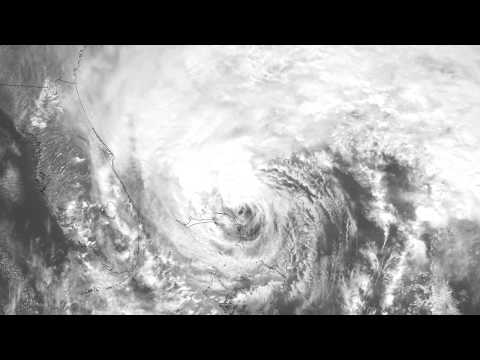
    Is that sandy off the coast of Florida now? It looks big.

    Thats her yes... the cloud structure is certainly vast!
    Florida could have a bad impact later on too with possible 55 -60mph winds there!


  • Registered Users Posts: 5,932 ✭✭✭Storm 10


  • Registered Users Posts: 11,134 ✭✭✭✭maquiladora


    From a National Weather Service discussion.
    THE DETERMINISTIC GUIDANCE (PARTICULARLY THE 00 UTC ECMWF) SHOW PRESSURE SOLUTIONS WELL BEYOND WHAT HAS EVER BEEN OBSERVED NEAR THE NEW JERSEY/NEW YORK COAST (EVEN EXCEEDING THE 1938 LONG ISLAND EXPRESS HURRICANE) EARLY IN THE MEDIUM RANGE PERIOD.


  • Registered Users Posts: 420 ✭✭Green Diesel


    There is still a lot of leaves on the trees here, and even more so further south. I'd say power outages could be widespread with the resulting fallen trees / branches.


  • Registered Users Posts: 11,134 ✭✭✭✭maquiladora


    This is from a satellite has have been specially focused on Sandy. 1km resolution, 1 frame per minute, right up to the minute. The zoom feature is great to see the detail in the structure.

    http://www.ssec.wisc.edu/data/1min/


  • Advertisement
  • Registered Users Posts: 14,513 ✭✭✭✭M.T. Cranium


    Agree that any model depictions below 940 mb suspect which is why the Euro track is also suspect now. 12z GFS and GEM fairly similar, huge impact landfalls near NYC from ESE direction with steady explosive deepening into the 940s on Monday night into Tuesday morning. Catastrophic outcome for large part of NY, NJ, CT from that. Wind gust potential 120 mph and storm surge well over 8' which may not sound like much but large parts of Long Island and northern NJ are very flat if in some cases behind rather broken sand dunes, and then parts of lower Manhattan at risk, and this excludes funnelling effects possible in various bays and inlets notably Rhode Island's Narragansett Bay (scene of horrific surge in 1938). Boston reader(s) note this track is worryingly close to major impact for Boston although would be more moderate probably (but still a huge storm).

    Earlier the less reliable (in storms) NAM began to pick up its game at 12z with the terminal 84h forecast showing eastern Long Island 958 mbs. This suggested to me that the GFS 945 mb type track was gaining support.

    Now all eyes on Euro to see if it will begin to drift towards the nNJ or LI landfall scenario or hold with the Delmarva into PA concept and also whether it will try to retain that 930ish central pressure.

    Although I stress that I don't believe the Euro verbatim, the implications of the model solution would be utter devastation from Ocean City MD well up the NJ coast, massive storm surge into Delaware Bay and huge inland flooding problems MD and PA. The impact to NYC would remain considerable then it would drop off (relative to GFS-GEM as discussed) to quite moderate eastern LI and CT and low impact eastern MA.

    To put the central pressures into context, Daniel Defoe storm of 1703 may have hit 945 mbs, Big Wind of Jan 1839 in northwest Ireland may have hit about 920-930 so the Euro would be talking about a storm in that range, the GFS more like the Jan 2005 Hebrides event or the Defoe storm or the 1953 Northern Ireland to North Sea storm (similar storm surge enhancement potential also).

    Agree that the storm looking technically subtropical but public perception concerns are going to force the NHC to keep "hurricane" wording in place perhaps longer than scientific justification, we are dealing with perhaps a millennial type event here or a unique singularity. Terminology is not as important as scale here.

    Final point, the term "warm seclusion" may appear in discussions. This means basically "hybrid" in that while post-tropical the low still retains a warm core with limited cold air wrapping around central circulation. Can't overstress the explosive potential of this storm dragging 576 dm thicknesses into a 50-dm height falling capture evolution, in layman's terms, it's a hurricane getting eaten up by a subarctic vortex so the thermal gradients between 24 C ocean source region (before landfall) and -2 C injection from transforming land-based air mass already dropping snow on hills -- it is another form of the perfect storm (although not the same dynamics as "the" perfect storm of this time of year offshore in 1991).

    I need a rest now.


  • Registered Users Posts: 11,134 ✭✭✭✭maquiladora


    Extreme precipitation index for Sandy, posted by Dr Jeff Masters on his blog.

    YNd9m.png

    The red areas are 1 in 100 year rainfalls. The pink areas are up to 1 in 500 year rainfalls.

    On closer inspection there are even small purple areas, which, based on this chart, would make the rainfall a 1 in 1,000 year event for those local areas.

    cdA3A.jpg

    "The recurrence interval statistics were computed based on precipitation frequency estimates from NOAA Atlas 14 Volume 2, published in 2004 "

    So yeah, lets hope the models are wrong. And rainfall is only one of the concerns with this.


  • Registered Users Posts: 14,513 ✭✭✭✭M.T. Cranium


    Euro has shifted to the GFS track. Long Island now the most likely landfall.

    This is good news for Ocean City MD and Atlantic City, Philadelphia. We can't say they are fully escaped from danger yet, but no major model goes south west of the mouth of the Hudson now.

    There are hints of a less extreme pressure solution in this suite as well, but the GFS was holding to near 950 mbs, Euro rather indeterminate due to time intervals and landfall timing.

    Further twists in the road possible but I suspect that very shortly, once this consensus becomes apparent, we'll be hearing a co-ordinated story from the NWS and NHC, US gov't agencies and state governments. Virginia has declared a state of emergency but that was forced by some kind of timeline and could be rescinded.


  • Registered Users Posts: 14,513 ✭✭✭✭M.T. Cranium


    By the way, that shift in the Euro parrtially invalidates the rainfall map above but it looks to be a partial (first half) solution for the total storm ending after first 24h in any case, now with the shift you could now expect heaviest rainfalls in e PA and e NY, n NJ, w CT-MA and VT. The current model consensus track might give 1-2 inches in DC and 4-6 in PHL but 8-16 inches (200-400 mm) in parts of ne PA, n NJ and se NY.

    Snow potential is now about 5-15 inches over higher parts of w PA, w MD and much of WV, trending to 2-5 inches in Blue Ridge Mtns n VA and also eastern Ohio and higher parts of western NY state. Mixed precip likely for Great Lakes at lower elevations.

    Flood disasters are possible in parts of the NY-PA-NJ Catskill region.


  • Registered Users Posts: 11,134 ✭✭✭✭maquiladora


    By the way, that shift in the Euro invalidates the rainfall map above...

    Yep, I should have said that the chart is obviously dependent on the track. I'll post an updated version closer to landfall.


  • Advertisement
  • Registered Users Posts: 11,134 ✭✭✭✭maquiladora


    12Z ECMWF at 96 hours has a center of 940mb just inland, 10 miles southwest of Philadelphia.


  • Registered Users Posts: 5,273 ✭✭✭racso1975


    might be a stupid question but how does this look for Baltimore?


  • Registered Users Posts: 500 ✭✭✭Spindle


    This website is shows you data from stations located in the area, if anybody is interested.

    http://www.ndbc.noaa.gov/

    There are some buoys recording 30ft waves and they are only getting bigger.


  • Registered Users Posts: 11,134 ✭✭✭✭maquiladora


    Spindle wrote: »
    This website is shows you data from stations located in the area, if anybody is interested.

    http://www.ndbc.noaa.gov/

    There are some buoys recording 30ft waves and they are only getting bigger.


    Edit : Nevermind, the magicseaweed charts were way too low resolution. Found better output on NOAA and GFS is spot on.


  • Moderators, Motoring & Transport Moderators Posts: 9,885 Mod ✭✭✭✭Tenger


    I am usually in the US about 3-4 times a month, always East Coast or Chicago. Thankfully I am on 2 weeks leave at the moment. Would not want to be flying in this upcoming storm!

    Here's another scary chart showing predicted precipitation for US East coast on Tuesday midnite:
    http://www.twisterdata.com/data/models/gfs/3/maps/2012/10/26/12/GFS_3_2012102612_F132_PCPIN_96_HR.png


  • Registered Users Posts: 14,513 ✭✭✭✭M.T. Cranium


    I think that Baltimore will probably be on the margin of the strongest wind zone, but my subjective bias is that the track will continue to shift away from the Euro slightly and come in towards northern NJ. But on the official track at present Baltimore would get a period of 60-90 mph winds and about 8" (200 mm) of rain, with some surge possible up Chesapeake Bay although I would bet against that.

    From my track Baltimore would get NW backing to W winds of 40-60 mph and about 4 inches of rain, possibly much of that in two different time frames before and after the landfall period which could see a dry slot rotating around the storm at that point.

    Still all to be settled on this, just watching the early 18z NAM coming in, and it shows a 958 mb low near eastern Long Island at 06z Tuesday 30th (this is as far as the NAM goes) heading almost west and deepening. This model has a reputation of being pedestrian and slow to respond but more reliable near consensus 24-48h situations. This sort of signal from it seems consistent with a NYC landfall to me.


  • Registered Users Posts: 5,932 ✭✭✭Storm 10


    Just saw on Fox News now that the US Navy has ordered all ships on East Coast bases to sea to avoid the storm, all Navy and Airforce aircraft being moved to safer bases.


  • Closed Accounts Posts: 4,279 ✭✭✭Su Campu


    Some ships off the Carolinas have been reporting 40-45 knot winds this evening, well ahead of the storm.

    http://www.ogimet.com/cgi-bin/gsynop?lang=en&esc=4&nav=Yes&lat=30N&lon=075W&proy=orto&base=bluem&ano=2012&mes=10&day=26hora=21&vwi=Wi


  • Registered Users Posts: 11,134 ✭✭✭✭maquiladora


    NOAA Wave Watch III chart maxed out with an area of 15m mean wave heights out at sea.

    UvYlB.png

    Thats the 12Z though. Track has changed on the 18Z.


  • Registered Users Posts: 9,509 ✭✭✭irishgeo


    I'll be flying to tampa florida Wednesday morning via Atlanta though. Is this storm going to affect me.


  • Advertisement
  • Registered Users Posts: 11,134 ✭✭✭✭maquiladora


    irishgeo wrote: »
    I'll be flying to tampa florida Wednesday morning via Atlanta though. Is this storm going to affect me.

    I can't see how it would, no.


  • Closed Accounts Posts: 309 ✭✭Wolfe_IRE


  • Closed Accounts Posts: 309 ✭✭Wolfe_IRE


  • Registered Users Posts: 11,134 ✭✭✭✭maquiladora


    National Weather Service in New Jersey has issued an early public information statement.
    PUBLIC INFORMATION STATEMENT
    NATIONAL WEATHER SERVICE MOUNT HOLLY NJ
    631 PM EDT FRI OCT 26 2012

    ...POTENTIAL HISTORIC STORM FOR THE AREA...

    TROPICAL CYCLONE SANDY IS EXPECTED TO MOVE NORTHWARD AND THEN TAKE A
    TURN BACK TO THE NORTHWEST, MAKING LANDFALL ALONG THE MID ATLANTIC
    COAST. IT APPEARS THIS OCCURS SOMEWHERE BETWEEN THE DELMARVA
    PENINSULA AND WESTERN LONG ISLAND.

    SANDY IS EXPECTED TO INTENSIFY AS IT INTERACTS WITH AN UPPER LEVEL
    SYSTEM MOVING OUT OF THE GREAT LAKES, AND INDICATIONS ARE THAT OUR
    REGION MAY EXPERIENCE A WIDESPREAD DAMAGING STORM, POSSIBLY OF
    HISTORIC PROPORTIONS.


    WIDESPREAD DAMAGING WINDS ARE POSSIBLE. THE EXACT STORM TRACK IS
    STILL UNCERTAIN AND THIS WILL DETERMINE THE ACTUAL IMPACTS. HOWEVER,
    THE STORM IS FORECAST TO BE A LARGE STORM THEREFORE DO NOT FOCUS ON
    THE EXACT CENTER OF THE STORM. IT APPEARS THAT THE STRONGEST WINDS
    WILL OCCUR MONDAY AND TUESDAY.

    IN ADDITION, WIDESPREAD HEAVY RAIN /POSSIBLY AS MUCH AS 6 TO 10
    INCHES/ WOULD CAUSE SIGNIFICANT FLOODING ON RIVERS AND STREAMS
    ACROSS THE REGION. THIS COULD BE MAJOR TO EVEN RECORD FLOODING.
    RAIN CAN BE EXPECTED TO BEGIN DURING THE DAY SUNDAY OR SUNDAY
    EVENING AND THEN CONTINUE MONDAY WHEN IT WILL BECOME HEAVY AT
    TIMES. AS WATER IS PUSHED TOWARD THE COAST, COASTAL FLOODING WILL
    INCREASE AND THIS COULD BE TO MAJOR TO PERHAPS EVEN RECORD LEVELS
    ALONG THE COASTS OF NEW JERSEY AND DELAWARE
    . THE EXTENT OF THE
    COASTAL FLOODING WILL BE DEPENDENT ON THE TRACK OF THE STORM.

    THIS HAS THE POTENTIAL TO BE A LARGE AND RECORD SETTING STORM, WITH
    WIDESPREAD WIND DAMAGE, INLAND AND COASTAL FLOODING, AND BEACH
    EROSION. THE COMBINATION OF THE HEAVY RAIN AND WIND WILL CREATE THE
    POTENTIAL FOR WIDESPREAD POWER OUTAGES AND SIGNIFICANT FLOODING.
    AT
    THIS TIME, THE MOST LIKELY TIME FRAME FOR THE WORST OF THE RAIN AND
    WIND LOOKS TO BE MONDAY AND TUESDAY. THIS MEANS THERE IS STILL TIME
    TO PREPARE.

    SOME SUGGESTED PRE-STORM ACTIONS ARE:

    1. FUEL UP YOUR VEHICLES.

    2. IF YOU HAVE A GENERATOR, BE SURE YOU HAVE ADEQUATE FUEL ON HAND.

    3. TO PREPARE FOR THE POSSIBILITY OF PROLONGED POWER OUTAGES, MAKE
    SURE YOU HAVE A SUPPLY OF FRESH BATTERIES AND A SUPPLY OF CANDLES OR
    FLASHLIGHTS ON HAND.

    4. BE SURE TO HAVE SEVERAL DAYS OF FRESH WATER ON HAND FOR DRINKING
    AND COOKING.

    5. IF YOU STILL HAVE LAWN FURNITURE OUTSIDE, SECURE OR STORE IT
    INDOORS. SECURE ANY OUTSIDE ITEMS THAT COULD BECOME AIRBORNE IN
    STRONG WINDS, INCLUDING HALLOWEEN DECORATIONS.

    6. CLEAN OUT ANY STORM DRAINS OR GUTTERS THAT MAY BE CLOGGED BY
    LEAVES.

    7. IF YOU LIVE IN A FLOOD PRONE AREA AND IF POSSIBLE, CONSIDER
    MOVING ITEMS THAT MAY BECOME DAMAGED TO HIGHER GROUND.

    8. IF YOU HAVE LIMITED MOBILITY OR KNOW OF SOMEONE WHO MAY BE
    DISABLED, CONSIDER ARRANGING FOR TEMPORARY SHELTER IF THEY LIVE IN
    AN AREA THAT MAY FLOOD OR COULD LOSE POWER.

    9. IF YOU NEED TO EVACUATE, BE SURE TO CARE FOR YOUR PETS.

    $$

    NWS MOUNT HOLLY, NJ


  • Closed Accounts Posts: 2,693 ✭✭✭Redsunset


    Slamming into these regions at around 950mb.
    People should be getting out and away from coast. Storm surge tied with full moon looks devastating on paper and perhaps a reality.
    End of story.

    A6LzpsICAAAF6D6.png


  • Closed Accounts Posts: 4,279 ✭✭✭Su Campu


    I wouldn't like to be out on Montauk Point in that!


  • Closed Accounts Posts: 4,279 ✭✭✭Su Campu


    Container ship Sea Land Mercury (WKAW) just off the east Florida coast was reporting 60 kt winds and 9 metre waves at 00Z.

    WKAW 27003 99287 70796 41596 80160 10230 20201 49985 52025 78162 889// 22284 00280 21018 301// 41416 5//// 6//// 80210 ICE /////=

    It's only just set sail from Miami to Norfolk, Virginia, so its route will obviously take it close to Sandy. You'd think they have hung on a couple of days to let it pass!


  • Registered Users Posts: 11,134 ✭✭✭✭maquiladora


    Su Campu wrote: »
    I wouldn't like to be out on Montauk Point in that!

    nymont.gif


  • Closed Accounts Posts: 4,279 ✭✭✭Su Campu


    This is starting to get beyond interesting. Worrying would be the word.


  • Advertisement
  • Registered Users Posts: 11,134 ✭✭✭✭maquiladora


    Su Campu wrote: »
    This is starting to get beyond interesting. Worrying would be the word.

    Well, just taking Bridgeport for an example.

    Moderate Flood – 10.4ft MLLW
    Major Flood – 12.0ft MLLW
    Extreme Flood – 13.0ft MLLW
    Record Flood – 12.38ft MLLW – 1938 Hurricane

    Zputk.gif

    Speaks for itself.


Advertisement