Advertisement
If you have a new account but are having problems posting or verifying your account, please email us on hello@boards.ie for help. Thanks :)
Hello all! Please ensure that you are posting a new thread or question in the appropriate forum. The Feedback forum is overwhelmed with questions that are having to be moved elsewhere. If you need help to verify your account contact hello@boards.ie

Hurricane Sandy Threatens To Slam Northeast U.S. Monday-Tuesday 29th-30th

Options
145791030

Comments

  • Registered Users Posts: 11,134 ✭✭✭✭maquiladora


    Then I just caught this on Twitter "Air Force recon reports min. central pressure of 955 mb from dropsonde. Appears earlier pressure drop has stabilized for now. - Hurricane Central / Weather Channel (@twc_hurricane)

    Latest dropsonde was 955 with a 13mph wind, it was 6mph on the 951 reading. They did a loop around aswell so they might have missed the center with that last fix.


  • Registered Users Posts: 11,134 ✭✭✭✭maquiladora


    The MTA has been directed by Governor Andrew M. Cuomo to begin an orderly shutdown and suspension of all subway, bus and commuter railroad service at 7 p.m. Sunday. The decision was made to protect customers, employees and equipment from the wrath of Hurricane Sandy as the strong storm continues its march up the east coast.

    http://alert.mta.info/


  • Registered Users Posts: 13,522 ✭✭✭✭fits


    Su Campu wrote: »
    So the crazy output of the models a couple of days ago was just that - crazy. We'll now have a windstorm of just typical Nor'easter proportions, the only difference will be the flooding.

    Meteorologically it's become a lot less interesting, hydrologically it's still a big one.

    I am failing to see whats underwhelming about it! Is it the windspeeds?


  • Registered Users Posts: 11,134 ✭✭✭✭maquiladora


    Looking wild at the Outer Banks, Norther Carolina, with Sandy over 400km away.

    http://www.visitob.com/webcams/sea-ranch-kill-devil-hills/


  • Registered Users Posts: 13,522 ✭✭✭✭fits


    ^ wild alright, I'd be nervous if my house were on the seafront there.


  • Advertisement
  • Registered Users Posts: 11,134 ✭✭✭✭maquiladora


    Some highlights from Dr Jeff Masters latest update which he has just posted.
    Sandy's tropical storm-force winds extended northeastwards 520 miles from the center, and twelve-foot high seas covered a diameter of ocean 1,030 miles across. Since records of storm size began in 1988, no tropical storm or hurricane has been larger (though Hurricane Olga of 2001 had a larger 690 mile radius of tropical storm-force winds when it was a subtropical storm near Bermuda.)
    Sandy's central pressure is expected to drop from its current 951 mb to 945 - 950 mb at landfall Monday night. A pressure this low is extremely rare; according to wunderground weather historian Christopher C. Burt, the lowest pressure ever measured anywhere in the U.S. north of Cape Hatteras, NC, is 946 mb (27.94") measured at the Bellport Coast Guard Station on Long Island, NY on September 21, 1938 during the great "Long Island Express" hurricane.
    Last night's 9:30 pm EDT H*Wind analysis from NOAA's Hurricane Research Division put the destructive potential of Sandy's winds at a modest 2.6 on a scale of 0 to 6. However, the destructive potential of the storm surge was exceptionally high: 5.7 on a scale of 0 to 6. This is a higher destructive potential than any hurricane observed between 1969 - 2005, including Category 5 storms like Katrina, Rita, Wilma, Camille, and Andrew.
    Sandy is now forecast to bring a near-record storm surge of 6 - 11 feet to Northern New Jersey and Long Island Sound, including the New York City Harbor. While Sandy's storm surge will be nowhere near as destructive as Katrina's, the storm surge does have the potential to cause many billions of dollars in damage if it hits near high tide at 9 pm EDT on Monday. The full moon is on Monday, which means astronomical high tide will be about 5% higher than the average high tide for the month. This will add another 2 - 3" to water levels. Fortunately, Sandy is now predicted to make a fairly rapid approach to the coast, meaning that the peak storm surge will not affect the coast for multiple high tide cycles. Sandy's storm surge will be capable of overtopping the flood walls in Manhattan, which are only five feet above mean sea level

    The full article is a good read.

    http://www.wunderground.com/blog/JeffMasters/comment.html?entrynum=2278


  • Registered Users Posts: 84 ✭✭Wicklow Weather


    Looking wild at the Outer Banks, Norther Carolina, with Sandy over 400km away.

    http://www.visitob.com/webcams/sea-ranch-kill-devil-hills/

    Thanks for that and its only being side swiped by the storm! I posted this link to our Facebook site, hope you dont mind maquiladora


  • Registered Users Posts: 11,134 ✭✭✭✭maquiladora


    Thanks for that and its only being side swiped by the storm! I posted this link to our Facebook site, hope you dont mind maquiladora

    Why would I mind? :pac:


  • Closed Accounts Posts: 5,150 ✭✭✭Deep Easterly


    Sponge Bob wrote: »
    Others are quoting model outputs.

    I was quoting analysis, not model outputs. But 951 hPa confirmed on the 12z, a drop of 9.0 hPa in 3 hours.

    2uzwa3d.jpg


  • Registered Users Posts: 11,134 ✭✭✭✭maquiladora


    Zone A evacuation in NYC announced. 375,000 people.
    Benedict Moran ‏@benmoran

    Cars with loudspeakers going around the city ordering evacuation.


  • Advertisement
  • Registered Users Posts: 13,008 ✭✭✭✭bnt


    If you're wondering where the various zones are, there's a map in the Ready New York brochure (PDF).

    Death has this much to be said for it:
    You don’t have to get out of bed for it.
    Wherever you happen to be
    They bring it to you—free.

    — Kingsley Amis


  • Registered Users Posts: 11,134 ✭✭✭✭maquiladora


    Sandy's current Integrated Kinetic Energy is now 313 terajoules. This is higher than any tropical cyclone in recorded history. Katrina peaked at 117.

    ftp://ftp.aoml.noaa.gov/hrd/pub/hwind/Operational/2012/AL182012/1028/1330/AL182012_1028_1330_contour08.png
    Tropical cyclone damage potential, as currently defined by the Saffir-Simpson scale and the maximum sustained surface wind speed in the storm, fails to consider the area impact of winds likely to force surge and waves or cause particular levels of damage. Integrated kinetic energy represents a framework that captures the physical process of ocean surface stress forcing waves and surge while also taking into account structural wind loading and the spatial coverage of the wind.

    http://www.aoml.noaa.gov/hrd/ike/

    www.aoml.noaa.gov/hrd/Powell/BAMS_IKE_Paper_final.pdf


  • Registered Users Posts: 5,068 ✭✭✭Iancar29


    Sandy's current Integrated Kinetic Energy is now 313 terajoules. This is higher than any tropical cyclone in recorded history. Katrina peaked at 117.

    ftp://ftp.aoml.noaa.gov/hrd/pub/hwind/Operational/2012/AL182012/1028/1330/AL182012_1028_1330_contour08.png


    http://www.aoml.noaa.gov/hrd/ike/

    www.aoml.noaa.gov/hrd/Powell/BAMS_IKE_Paper_final.pdf


    Edited that for ya for a more of a :eek: factor ....


  • Banned (with Prison Access) Posts: 25,234 ✭✭✭✭Sponge Bob


    0.31 Petajoules..even. How many joules are incoming from the west to meet it BTW?


  • Banned (with Prison Access) Posts: 25,234 ✭✭✭✭Sponge Bob


    Latest Dropsonde 952. Dropsondes listed here and that was a 15.09 z effort.

    http://www.tropicalatlantic.com/recon/archive/storm.cgi?year=2012&storm=Sandy&product=UZNT13


  • Registered Users Posts: 5,068 ✭✭✭Iancar29


    Anyone find any decent newstreams yet?


  • Closed Accounts Posts: 4,279 ✭✭✭Su Campu


    774 flights are cancelled at Newark tomorrow, 428 at Washington Dulles and 355 at Philadelphia.

    Newark's latest TAF, valid til 18Z Monday, shows winds increasing to NE43G60 kts by then.


  • Registered Users Posts: 5,068 ✭✭✭Iancar29


    Just talking to my Cousin there on fb , she only moved to NY 3 weeks ago....

    Got her job intership there last week , they were told to go home this morning and not to ring back on Wednesday AT LEAST to see if she should be going in or not.

    Shes in good spirit though.. " gonna get supplies and alot of books.... looks like ill be reading alot over the next few days! "


  • Registered Users Posts: 1,821 ✭✭✭hawkwing


    A mother of a storm coming in :eek:
    http://www.nhc.noaa.gov/text/refresh/MIATCPAT3+shtml/281753.shtml?

    BULLETIN
    HURRICANE SANDY INTERMEDIATE ADVISORY NUMBER 25A
    NWS NATIONAL HURRICANE CENTER MIAMI FL AL182012
    200 PM EDT SUN OCT 28 2012

    ...SANDY EXPECTED TO BRING LIFE-THREATENING STORM SURGE FLOODING TO
    THE MID-ATLANTIC COAST...INCLUDING LONG ISLAND SOUND AND NEW YORK
    HARBOR...
    ...WINDS FORECAST TO BE NEAR HURRICANE FORCE AT LANDFALL...
    ...HEAVY SNOW EXPECTED IN PORTIONS OF THE APPALACHIAN MOUNTAINS...


    SUMMARY OF 200 PM EDT...1800 UTC...INFORMATION
    LOCATION...32.8N 71.9W
    ABOUT 270 MI...440 KM SE OF CAPE HATTERAS NORTH CAROLINA
    ABOUT 575 MI...930 KM S OF NEW YORK CITY
    MAXIMUM SUSTAINED WINDS...75 MPH...120 KM/H
    PRESENT MOVEMENT...NE OR 50 DEGREES AT 14 MPH...22 KM/H
    MINIMUM CENTRAL PRESSURE...951 MB...28.08 INCHES


    WATCHES AND WARNINGS
    CHANGES WITH THIS ADVISORY...

    NONE.

    SUMMARY OF WATCHES AND WARNINGS IN EFFECT...

    A TROPICAL STORM WARNING IS IN EFFECT FOR...
    * CAPE FEAR TO DUCK NORTH CAROLINA
    * PAMLICO AND ALBEMARLE SOUNDS
    * BERMUDA

    IN ADDITION...HURRICANE-FORCE WINDS ARE EXPECTED ALONG PORTIONS OF
    THE COAST BETWEEN CHINCOTEAGUE VIRGINIA AND CHATHAM MASSACHUSETTS.
    THIS INCLUDES THE MIDDLE AND UPPER CHESAPEAKE BAY...DELAWARE
    BAY...AND THE COASTS OF THE NORTHERN DELMARVA PENINSULA...NEW
    JERSEY...THE NEW YORK CITY AREA...LONG ISLAND...CONNECTICUT...AND
    RHODE ISLAND.


  • Registered Users Posts: 5,068 ✭✭✭Iancar29


    550253_522167497812570_1037897300_n.jpg


  • Advertisement
  • Registered Users Posts: 11,134 ✭✭✭✭maquiladora


    NWS New York NY ‏@NWSNewYorkNY

    Predicted water level of 11.7 ft at the Battery #NYC at 8:13PM MON would break record of 10.5 ft on 9/15/60 with Hurr. Donna.

    When you combine that with this...
    If the storm surge from Irene (last year) had been just one foot higher, "subway tunnels would have flooded, segments of the Franklin D. Roosevelt Drive and roads along the Hudson River would have turned into rivers, and sections of the commuter rail system would have been impassable or bereft of power," he said, and the subway tunnels under the Harlem and East Rivers would have been unusable for nearly a month, or longer, at an economic loss of about $55 billion.

    Sandy will be very, very costly if things go according to forecast now.


  • Registered Users Posts: 14,513 ✭✭✭✭M.T. Cranium


    Could recommend browsing regional forums on American Weather Forum at

    http://www.americanwx.com

    You could consider joining as some graphics will appear only as links, but there is a delay longer than the storm lead time. This is basically a weather forum equivalent to Net-weather and nowadays to this one, except that it has a larger "pro met" contingent. If you browse the NYC regional forum you can stay on top of local and regional developments, also southern New England and PHL forums will be good sources.

    Local time for your information will be 4 hrs behind as North America stays on daylight savings time for an extra week or two (this week for sure).

    There is considerable debate on that forum about how effectively 100-mph winds can or will mix down to surface late Monday but most people now understand the potential for wind damage, however, the storm surge issue has really dominated attention because it can and probably will do most of the damage as well as potentially lead to the most casualties.

    Rest of this is a longish post about regional geography, if you know that already or don't care, would suggest you stop reading now.

    For those who aren't as familiar as some with the regional geography, I thought I would mention these basic facts to orient you -- you may wish to consult a map during or after reading this (or before, there are so many ways it would make your head spin).

    New York City consists of five boroughs. These are Staten Island, located southwest of the best known Manhattan which is also an island. Two more are Brooklyn and Queens which are on Long Island. The Bronx is on the mainland and immediately south of the city of Yonkers. From there you could go northeast into New Rochelle and into CT, major cities there along the north shore of Long Island Sound include Stamford, New Haven and Bridgeport. Further east is Rhode Island which is almost all built around Narragansett Bay, another place severely affected in 1938 by storm surge. East of that you have Massachusetts with seaport cities like New Bedford, Fall River then Cape Cod which is generally quite flat, and greater Boston which is a bit similar to Dublin without local mountains in its set-up. Going back west, the Connecticut River forms the border of NH-VT then bisects MA (Mass) and CT passing through Hartford on its way to the Sound. This region is hilly and western CT has a higher range of hills known as the Berkshires which are maybe 800-1000 metres at their summits. Any TV masts or repeater stations up there are going to be stressed by this storm for sure.

    Getting back to Long Island, from the NYC boroughs east would all be suburban sprawl to about the halfway point, after which, the permanent settlement and summer homes are mostly just inland from coast behind sand dunes of various heights. Otherwise this is a very flat expanse not very far above sea level. The city itself has somewhat higher elevations and in some parts, built up sea walls that would repel any imaginable surges.

    Just a brief aside, the main airports -- JFK is southeast of Brooklyn, the southern part of Brooklyn being Jamaica, and those areas are being evacuated as they are particularly low-lying and recovered swamp land. Coney Island is another beach to their west, you may also hear about Long Beach and Fire Island which are immediately to the east of JFK, and then the Hamptons (like Westhampton, Easthampton) which are ritzy seaside areas well to their east. That is the region devastated by storm surges and wind in the 1938 'cane.

    Now going over to the New Jersey side, this is a huge complex of cities and towns with millions of people in total, Newark, Elizabeth, Jersey City and Passaic are the biggest of them but there are dozens of others and the urban sprawl goes about halfway west to the Delaware River which is the western boundary of New Jersey with PA. The western half of that region is hilly, forested and just a little bit suburban. Of particular concern in this storm threat, Raritan Bay which receives the Raritan River could back up into the river and this area is surrounded by major oil refineries and petrochemical plants. The region from what I recall on visits is swampy, very close to sea level with small areas of hills rising maybe 50-100 feet above the plain, trending to rolling hills about 20-30 miles inland. A large storm surge could back up a long way into all kinds of tributary creeks before totally disappearing.

    Further south into coastal New Jersey, you have a long barrier island of sand dunes with considerable development, salt-water lagoons behind these and a low, swampy mainland that slowly trends into pine scrub flatland that has become semi-suburban sprawl between greater NYC and greater Philly. Atlantic City down the coast is a big resort town with casinos. They are probably going to have moderate tidal problems but on this track they may escape the worst of the surges. Long Branch and Asbury Park further north could take a direct hit.

    To finish this off, the New Jersey Turnpike running from NYC to Philly would take you past the state capital Trenton which is on the aforementioned Delaware River and into Camden which is the NJ side of Philadelphia, generally speaking Camden is a depressed area. About 90% of the population of greater Philly is on the PA side and from there west and north you get into rolling hills, river valleys that all have major towns and cities in them like Lancaster, Allentown-Bethlehem, Easton and Scranton. This is from what I dimly remember similar terrain to Kildare and Dublin-Meath.

    Hope this gives you a better idea of what this region (of 75 million people) is generally like, as it awaits the storm of the century.


  • Registered Users Posts: 209 ✭✭FootShooter


    Google News realtime coverage of Hurricane Sandy is pretty good if you want to follow news articles and reports about the Hurricane.

    Reuters Live tracking is pretty good as well, they some nice pictures up.


  • Registered Users Posts: 500 ✭✭✭Spindle


    Iancar29 wrote: »
    Anyone find any decent newstreams yet?

    The guardian have one here which is live updated.

    http://www.guardian.co.uk/world/2012/oct/28/hurricane-sandy-new-york-coast?CMP=twt_gu

    Also if you look at this blog, he has put up a huge list of webcams to watch beaches etc

    http://qz.com/20761/watch-these-webcams-as-hurricane-sandy-hits-the-us-east-coast/

    These are some of the better webcams:

    http://www.vbbound.com/webcam/hampton-inn-virginia-beach/

    http://earthcam.com/usa/newyork/coneyisland/

    http://www.surfline.com/surf-report/lincoln-northeast_4269

    The last link has a good few surfers out there, not wild yet, but I wonder how long they will last out there.


  • Registered Users Posts: 11,134 ✭✭✭✭maquiladora


    12Z ECM has 120 knot winds at 850mb level at 24 hours.

    A6UDLylCEAA4ssq.png

    MT, what degree of mixing could we see of upper winds down to the surface?


  • Moderators, Technology & Internet Moderators Posts: 17,134 Mod ✭✭✭✭cherryghost


    BBC coverage is interesting:
    It is only moving north-east at 14mph, and could hit as many as 12 states, bringing up to 25cm of rain, 60cm of snow, extreme storm surges and power cuts.

    States of emergency have been declared in Maryland, New York, Pennsylvania, Virginia, Washington DC and a coastal county in North Carolina.

    The NHC said further strengthening was possible on Sunday, before Sandy touched down anywhere between Virginia and southern New England late on Monday.

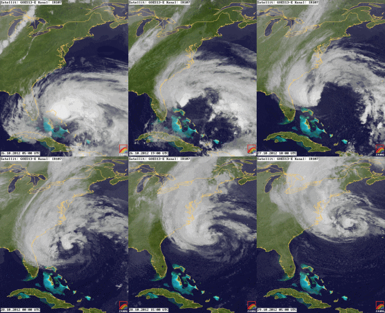
    Also, NASA released this. Looks really impressive.

    xlarge.jpg


  • Registered Users Posts: 12,778 ✭✭✭✭ninebeanrows


    It will be hard one to judge being a quasi tropical storm, winds could remain very high at low levels.


  • Registered Users Posts: 5,932 ✭✭✭Storm 10


    mtholly.png


  • Registered Users Posts: 1,778 ✭✭✭sebastianlieken


    So i'm in Manhatten at the moment with my flight due to leave on monday at 20:40

    on a scale of 1 - 10, how buggered am I?


  • Advertisement
  • Banned (with Prison Access) Posts: 25,234 ✭✭✭✭Sponge Bob


    A Canadian Hurricane Centre sounds as useful as a Cork Snow Cover Index but there is one and it is predicting dire news for Ontario :)

    http://www.nationalpost.com/m/wp/news/world/blog.html?b=news.nationalpost.com/2012/10/28/hurricane-sandy-frankenstorm


Advertisement