Advertisement
If you have a new account but are having problems posting or verifying your account, please email us on hello@boards.ie for help. Thanks :)
Hello all! Please ensure that you are posting a new thread or question in the appropriate forum. The Feedback forum is overwhelmed with questions that are having to be moved elsewhere. If you need help to verify your account contact hello@boards.ie

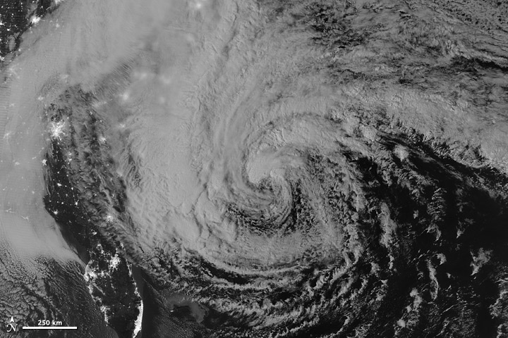
Hurricane Sandy Threatens To Slam Northeast U.S. Monday-Tuesday 29th-30th

Options
1679111230

Comments

  • Registered Users Posts: 11,134 ✭✭✭✭maquiladora


    Bermuda and North Carolina getting sustained tropical storm force winds from the same hurricane at the same time. And the wind field is even wider diagonally. Incredible.

    yCUpZ.gif


  • Moderators, Recreation & Hobbies Moderators Posts: 10,912 Mod ✭✭✭✭Ponster


    This is the so-far rather boring weather in outside my window in Manhattan (57th street, 15th floor)


  • Registered Users Posts: 14,513 ✭✭✭✭M.T. Cranium


    You might be surprised (Sponge Bob) how many tropical systems end up making significant impacts in Canada and some of them not yet extratropical. But the Canadian Hurricane Centre is basically a small operation within our national weather service that co-ordinates with the NHC to issue warnings mostly in eastern Canada near the Atlantic but occasionally into southern Ontario.

    Hazel (1954) was considered a tropical storm to Lake Ontario and resulted in 100-200 mm rainfalls around Toronto, and flooding that killed 80 people. A hurricane that hit southeast Newfoundland before they joined Canada (the storm in 1927) wiped out a fishing fleet and produced a deadly storm surge into Placentia Bay. Those are the two worst impacts that come to mind, but the eastern coast gets major impacts almost every year from storms that are just about in the transition phase, some are fully tropical until after landfall.

    Getting back to southern Ontario, many famous hurricanes have gone inland and recurved through Ontario as post-tropical but strong systems. Daily rainfall records at Toronto (period 1841 to present) include perhaps 30 or more such cases. Herre's a partial list from memory (I don't have time today to look this up)

    end of June 1957, Audrey ... 24-hour rainfall record for any date in June

    Sep 1989 ... Hugo went almost over my head in Peterborough ON 24h after landfall, we had a Charley-like rainfall event as a result

    Sep 1878 ... record 24h rainfalls on two consecutive days from the storm that made landfall in Georgia and went due north

    Oct 15 1954 ... Hazel, set daily rainfall record for any day of year, and also wind records sustained and gusts (something like 60 mph gusting 90)

    Sep 9 1900 ... The Galveston hurricane whizzed past, nothing much happened as it went north of Toronto

    Sep 1988 ... Roughly the same story as above, Gilbert

    Aug 28-29 1992 ... A very soggy weekend (dates may be wrong) thanks to Andrew.

    June 24 1968 ... TS Candy dropped 3" of rain

    June 21 1972 ... Agnes which dropped 18" rain near NY-PA border dropped about 2 inches in Toronto. Record low max for date as cold air pulled into looping circulation.

    Sep 12-13 1979 ... Frederic raced across eastern ON, 6" rain in Kingston and Cornwall ON


    sure I've forgotten a few others, but you get the idea ... the Great Lakes are sometimes the graveyard of big tropical systems. They don't all head across the Atlantic. Hazel ended up in Foxe Basin (!)


  • Registered Users Posts: 539 ✭✭✭morebabies


    Ponster wrote: »
    This is the so-far rather boring weather in outside my window in Manhattan (57th street, 15th floor)


    Please keep us posted, if you can safely do so! Thanks for that glimpse.


  • Registered Users Posts: 11,134 ✭✭✭✭maquiladora


    Senior meteorologist at The Weather Channel, Stu Ostro just posted this.

    - History is being written as an extreme weather event continues to unfold, one which will occupy a place in the annals of weather history as one of the most extraordinary to have affected the United States.

    - REGARDLESS OF WHAT THE OFFICIAL DESIGNATION IS NOW OR AT/AFTER LANDFALL -- HURRICANE (INCLUDING IF "ONLY" A CATEGORY ONE), TROPICAL STORM, POST-TROPICAL, EXTRATROPICAL, WHATEVER -- OR WHAT TYPE OF WARNINGS ARE ISSUED BY THE NATIONAL WEATHER SERVICE AND NATIONAL HURRICANE CENTER -- PEOPLE IN THE PATH OF THIS STORM NEED TO HEED THE THREAT IT POSES WITH UTMOST URGENCY.

    - TAKE COASTAL FLOODING EVACUATION ORDERS SERIOUSLY; PREPARE FOR DOWNED TREES AND STRUCTURAL DAMAGE BY OBSERVING TORNADO SAFETY GUIDELINES, I.E. STAYING INSIDE AND GETTING INTO THE LOWEST, MOST-INTERIOR PORTION OF THE BUILDING OR ANOTHER DESIGNATED SAFE PLACE; BE KEENLY AWARE OF YOUR LOCATION'S SUSCEPTIBILITY TO FLASH FLOODING (URBAN AND SMALL STREAM) FROM RAINFALL AND RIVER RISES; KNOW THAT YOU COULD BE WITHOUT POWER FOR A LONG TIME BUT ALSO UNDERSTAND THE DANGERS OF CARBON MONOXIDE POISONING FROM IMPROPER USE OF GENERATORS.

    - With Sandy having already brought severe impacts to the Caribbean Islands and a portion of the Bahamas, and severe erosion to some beaches on the east coast of Florida, it is now poised to strike the northeast United States with a combination of track, size, structure and strength that is unprecedented in the known historical record there.

    - Already, there are ominous signs: trees down in eastern North Carolina, the first of countless that will be blown over or uprooted along the storm's path; and coastal flooding in Florida, North Carolina and Virginia, these impacts occurring despite the center of circulation being so far offshore, an indication of Sandy's exceptional size and potency.

    - A meteorologically mind-boggling combination of ingredients is coming together: one of the largest expanses of tropical storm (gale) force winds on record with a tropical or subtropical cyclone in the Atlantic or for that matter anywhere else in the world; a track of the center making a sharp left turn in direction of movement toward New Jersey in a way that is unprecedented in the historical database, as it gets blocked from moving out to sea by a pattern that includes an exceptionally strong ridge of high pressure aloft near Greenland; a "warm-core" tropical cyclone embedded within a larger, nor'easter-like circulation; and eventually tropical moisture and arctic air combining to produce heavy snow in interior high elevations. This is an extraordinary situation, and I am not prone to hyperbole.

    - That gigantic size is a crucially important aspect of this storm. The massive breadth of its strong winds will produce a much wider scope of impacts than if it were a tiny system, and some of them will extend very far inland. A cyclone with the same maximum sustained velocities (borderline tropical storm / hurricane) but with a very small diameter of tropical storm / gale force winds would not present nearly the same level of threat or expected effects. Unfortunately, that's not the case. This one's size, threat, and expected impacts are immense.

    - Those continue to be: very powerful, gusty winds with widespread tree damage and an extreme amount and duration of power outages; major coastal flooding from storm surge along with large battering waves on top of that and severe beach erosion; flooding from heavy rainfall; and heavy snow accumulations in the central Appalachians.

    - Sandy is so large that there is even a tropical storm warning in effect in Bermuda, and the Bermuda Weather Service is forecasting wave heights outside the reef as high as 30'.

    - There is a serious danger to mariners from a humongous area of high seas which in some areas will include waves of colossal height. Wave forecast models are predicting significant wave heights up to 50+ feet, and that is the average of the top 1/3, meaning that there will be individual waves that are even higher. The Perfect Storm, originally known as the Halloween Storm because of the time of year when it occurred, peaking in 1991 on the same dates (October 28-30) as Sandy, became a part of popular culture because of the tragedy at sea. This one has some of the same meteorological characteristics and ingredients coming together, but in an even more extreme way, and slamming more directly onshore and then much farther inland and thus having a far greater scope and variety of impacts.


  • Advertisement
  • Closed Accounts Posts: 309 ✭✭Wolfe_IRE


    sandy_vir_2012302.jpg
    This image of Hurricane Sandy was acquired by the Visible Infrared Imaging Radiometer Suite (VIIRS) on the Suomi NPP satellite around 2:42 a.m. Eastern Daylight Time (06:42 Universal Time) on October 28, 2012.


    The storm was captured by a special “day-night band,” which detects light in a range of wavelengths from green to near-infrared and uses filtering techniques to observe dim signals such as auroras, airglow, gas flares, city lights, and reflected moonlight. In this case, the cloud tops were lit by the nearly full Moon (full occurs on October 29). Some city lights in Florida and Georgia are also visible amidst the clouds.


  • Moderators, Recreation & Hobbies Moderators Posts: 10,912 Mod ✭✭✭✭Ponster


    morebabies wrote: »
    Please keep us posted, if you can safely do so! Thanks for that glimpse.

    Welcome.

    I'm working from home tomorrow but I plan on heading into the office in the afternoon to get some photos/videos as I work on the 48th floor of the World Financial Center, overlooking the Hudson River and opposite the WTC Tower 1.


  • Registered Users Posts: 500 ✭✭✭Spindle


    I hope there are no Nuclear reactors that are vulnerable to the storm surge. There are a lot of them clustered on the east coast. Just saw mention of this a while back
    The Nuclear Regulatory Commission says it will have on-site inspectors at all nuclear power stations that could be affected by Hurricane Sandy. The inspectors will be in place ahead of the storm and will stay at the power plants until the event is over.

    No power station has been taken offline at this point, but each station has protocols and procedures for going offline, NRC spokesman Neil Sheehan said.


  • Closed Accounts Posts: 309 ✭✭Wolfe_IRE


    Coastal Watches/Warnings and 5-Day Forecast Cone for Hurricane Sandy
    226174.gif


  • Closed Accounts Posts: 309 ✭✭Wolfe_IRE


    At noon Eastern Daylight Time (16:00 Universal Time) on October 28, 2012, the Moderate Resolution Imaging Spectroradiometer (MODIS) on NASA’s Terra satellite acquired this image of Hurricane Sandy off the southeastern United States.

    226175.jpg


  • Advertisement
  • Closed Accounts Posts: 4,279 ✭✭✭Su Campu


    Su, any news of those ships? I've been thinking about them all day. :(

    Sea Land Mercury was reporting 60 knot winds, with 11 m waves and 9 metre swell, at 1500 Z today.

    Use this map to see positions and reports from all ships and buoys in the vicinity of Sandy.

    508dad5a_343b_0.png


  • Registered Users Posts: 11,134 ✭✭✭✭maquiladora


    Wolfe_IRE wrote: »
    Coastal Watches/Warnings and 5-Day Forecast Cone for Hurricane Sandy

    Notice the no watches/warnings north of NC.
    AS NOTED IN PREVIOUS ADVISORIES...TO AVOID A HIGHLY DISRUPTIVE
    CHANGE FROM TROPICAL TO NON-TROPICAL WARNINGS WHEN SANDY BECOMES
    POST-TROPICAL...THE WIND HAZARD NORTH OF THE TROPICAL STORM WARNING
    AREA WILL CONTINUE TO BE CONVEYED THROUGH HIGH WIND WATCHES AND
    WARNINGS ISSUED BY LOCAL NATIONAL WEATHER SERVICE OFFICES.

    So even though there will be no tropical warnings there...
    HURRICANE-FORCE WINDS ARE EXPECTED ALONG PORTIONS OF
    THE COAST BETWEEN CHINCOTEAGUE VIRGINIA AND CHATHAM MASSACHUSETTS.
    THIS INCLUDES THE TIDAL POTOMAC FROM COBB ISLAND TO SMITH POINT...
    THE MIDDLE AND UPPER CHESAPEAKE BAY...DELAWARE BAY...AND THE COASTS
    OF THE NORTHERN DELMARVA PENINSULA...NEW JERSEY...THE NEW YORK CITY
    AREA...LONG ISLAND...CONNECTICUT...AND RHODE ISLAND.


  • Registered Users Posts: 5,565 ✭✭✭Pangea


    Senior meteorologist at The Weather Channel, Stu Ostro just posted this.

    Thats a bone chilling read


  • Registered Users Posts: 3,610 ✭✭✭Pa ElGrande


    Net Zero means we are paying for the destruction of our economy and society in pursuit of an unachievable and pointless policy.


  • Registered Users Posts: 206 ✭✭megatron989


    Few days old, but a good vid here on the storm.


  • Registered Users Posts: 11 ahuminahumina


    Hi all
    Im out the back, glass of Tully in hand just staring up at the orangy light polluted sky. The wind is blowing fairly well but nothing too mad (yet).
    It's just amazing the size of this storm. We're still recovering from Irene last year. It hit us hard in southern Connecticut. We're not Florida like. Anyhow I hope ye all stay safe.


  • Registered Users Posts: 11,134 ✭✭✭✭maquiladora


    Hi all
    Im out the back, glass of Tully in hand just staring up at the orangy light polluted sky. The wind is blowing fairly well but nothing too mad (yet).
    It's just amazing the size of this storm. We're still recovering from Irene last year. It hit us hard in southern Connecticut. We're not Florida like. Anyhow I hope ye all stay safe.

    Hope yer not livin by the coast there! The forecast tide for Bridgeport tomorrow night is about 2ft above the record tide set during the 1938 hurricane.


  • Closed Accounts Posts: 4,279 ✭✭✭Su Campu


    MIMIC-TPW. Give it a minute to load.

    It shows total precipitable water, with the influx of drier air from Florida clearly visible through yesterday. That process has now finished and the system is looking a lot more organised has a window now to gather its thoughts before landfall tomorrow night. The only limiting factor is SSTs, which cool sharply from now to towards the coast.

    latest72hrs.gif


  • Registered Users Posts: 30 okfine


    Amazing to see what nature is capable of, it has no boundaries scary to think it is capable of creating such monster-like conditions :eek:


  • Registered Users Posts: 77 ✭✭JTC83


    I'm due to fly Dublin -> Paris -> Detroit -> Chicago on Tuesday. Can't figure out if i'm safe enough or likely to get caught up in it or caught in Paris. Any ideas of whether it's likely to affect me would be greatly appreciated. Thanks :-)


  • Advertisement
  • Registered Users Posts: 9,717 ✭✭✭YFlyer


    What is the probability that the hurricane path will ver to the North East and out across the Atlantic?


  • Registered Users Posts: 11,134 ✭✭✭✭maquiladora


    SUMMARY OF 800 PM EDT...0000 UTC...INFORMATION
    LOCATION...34.0N 70.9W
    ABOUT 280 MI...450 KM ESE OF CAPE HATTERAS NORTH CAROLINA
    ABOUT 485 MI...780 KM SSE OF NEW YORK CITY
    MAXIMUM SUSTAINED WINDS...75 MPH...120 KM/H
    PRESENT MOVEMENT...NE OR 45 DEGREES AT 15 MPH...24 KM/H
    MINIMUM CENTRAL PRESSURE...950 MB...28.05 INCHES

    Baroclinic deepening is forecast to start tomorrow when Sandy starts to turn towards the coast.


  • Registered Users Posts: 11,134 ✭✭✭✭maquiladora


    YFlyer wrote: »
    What is the probability that the hurricane path will ver to the North East and out across the Atlantic?

    Close to zero.


  • Banned (with Prison Access) Posts: 25,234 ✭✭✭✭Sponge Bob


    Dropsonde 01:32z shows a pressure of 950


  • Registered Users Posts: 4,811 ✭✭✭thomasj


    Close to zero.

    And even if it did I doubt it would be anywhere near half as strong as what's being threatened over the coming hours and days


  • Registered Users Posts: 11,134 ✭✭✭✭maquiladora


    Models getting a good idea on the landfall area now.

    JxwQE.gif

    The models showing it not hitting there are climatological models, not dynamic models. They are useless in an unusual setup like this.


  • Posts: 25,611 ✭✭✭✭ [Deleted User]


    Why do people always ask about Hurricanes hitting Ireland? We sometimes get the crappy remnants of storms split into several fronts a few weeks later, we don't get ****ing hurricanes.


  • Posts: 25,611 ✭✭✭✭ [Deleted User]


    Am I right in thinking a late swing to the North just at landfall would be worst for NYC? Strong winds followed by the ridiculously low centre?


  • Registered Users Posts: 11,134 ✭✭✭✭maquiladora


    Am I right in thinking a late swing to the North just at landfall would be worst for NYC? Strong winds followed by the ridiculously low centre?

    No, highest winds will be north of the center at landfall. Winds aren't going to be very high anyway, enough to knock out power over a very wide area because of the big wind field but not enough to cause serious structural damage, it's the surge/wave potential that is really dangerous with Sandy.


  • Advertisement
  • Posts: 25,611 ✭✭✭✭ [Deleted User]


    No, highest winds will be north of the center at landfall. Winds aren't going to be very high anyway, enough to knock out power over a very wide area because of the big wind field but not enough to cause serious structural damage, it's the surge/wave potential that is really dangerous with Sandy.

    Well that's what I was getting at, greatest surge in the centre or North of the centre where the winds are?


Advertisement