Advertisement
If you have a new account but are having problems posting or verifying your account, please email us on hello@boards.ie for help. Thanks :)
Hello all! Please ensure that you are posting a new thread or question in the appropriate forum. The Feedback forum is overwhelmed with questions that are having to be moved elsewhere. If you need help to verify your account contact hello@boards.ie

Malaysia Airlines flight MH370-Updates and Discussion

1113114116118119219

Comments

  • Registered Users, Registered Users 2 Posts: 6,700 ✭✭✭Mountainsandh


    That's also something that is niggling at me.

    What if someone did spot the plane in say, Bangladesh, Myanmar, Nepal, but decided not to tell for fear they would be in trouble ?
    I mean, how well tended are radars in Nepal for example ?
    How bad it would look for Myanmar to have let a commercial plane fly over their air space without doing anything ? I think they don't have the best record as regards human rights, what fear do their soldiers/workforce operate under ?
    What if normal reporting procedure had not been followed, and so someone somewhere is simply not telling in fear.


  • Registered Users, Registered Users 2 Posts: 69,440 ✭✭✭✭L1011


    Calina wrote: »
    Pretty sure one is Air India 182, was bombed in 1985.

    Parts of that were found, though.


  • Registered Users, Registered Users 2 Posts: 36,368 ✭✭✭✭BorneTobyWilde


    sopretty wrote: »
    Without a map, or a notion of where Langkawi is, this article is hard to follow for me. :(
    I'll let the experts comment and keep my nose out for a while!

    https://maps.google.ie/maps?ct=reset&tab=ll
    Search '' Langkawi Airport Langkawi Kedah Malaysia ''

    Zoom out to get your bearings as to where it is in conjunction to where the plane started to turn


  • Closed Accounts Posts: 195 ✭✭theKillerBite


    That's also something that is niggling at me.

    What if someone did spot the plane in say, Bangladesh, Myanmar, Nepal, but decided not to tell for fear they would be in trouble ?
    I mean, how well tended are radars in Nepal for example ?
    How bad it would look for Myanmar to have let a commercial plane fly over their air space without doing anything ? I think they don't have the best record as regards human rights, what fear do their soldiers/workforce operate under ?
    What if normal reporting procedure had not been followed, and so someone somewhere is simply not telling in fear.

    But if it took the Northern route then it must have landed/crashed on the ground and there would be some evidence of this. If it crashed on the ground it would have been picked up by the Chinese/British/Americans. When the Kursk exploded under the water in the Barents Sea, the British picked it up on their sensors back in England.


  • Closed Accounts Posts: 12,078 ✭✭✭✭LordSutch


    Anyone mention the Petronas towers as a possible target yet?

    Heard one of the experts on Sky News floating the idea that the plane might have been taken to be used in a terrorist attack on the Petronas Towers in Kuala Lumpur. The end game has not been played out yet according to him, which is a very chilling thought if true.


  • Advertisement
  • Registered Users, Registered Users 2 Posts: 5,485 ✭✭✭Thrill


    The USS Kidd is ending its search for the missing Malaysia Airlines jet in a few days, Defense Department officials said Monday.

    A Defense Department official indicated that U.S. Navy search planes looking for the missing jetliner have much greater search ranges than a ship. A P3 Orion plane will move its base to Phuket, Thailand, and a P8 plane will be deployed to Perth, Australia, and conducts its search from there.

    http://www.kmbz.com/USS-Kidd-Ending-Search-for-Malaysia-Airlines-Fligh/18608318


  • Registered Users, Registered Users 2 Posts: 12,780 ✭✭✭✭ninebeanrows


    I wonder could weather satellites provide any clues. I presume the data has been examined on different frequency over anticipated track for possible fires etc.

    Mad to think we have minute by minute imagery over the region but it probably just isnt resolved enough to pick up the jet.


  • Closed Accounts Posts: 195 ✭✭theKillerBite


    LordSutch wrote: »
    Anyone mention the Petronas towers as a possible target yet?

    Heard one of the experts on Sky News floating the idea that the plane might have been taken to be used in a terrorist attack on the Petronas Towers in Kuala Lumpur. The end game has not been played out yet according to him, which is a very chilling thought if true.

    There was an Al-Queda plot:
    Possible plot investigated after Al-Qaeda supergrass told court that four or five Malaysian men planned a passenger airliner hijack

    Badat, who was jailed for 13 years in 2005 for his part in a conspiracy with the “shoe bomber” Richard Reid to blow up a transatlantic jet, had given similar evidence in 2012.

    Badat told the court last week that he believed the Malaysians, including the pilot, were “ready to perform an act.”
    During the meeting, the possibility was raised that the cockpit door might be locked. Badat told the court: “So I said, 'How about I give you one of my bombs to open a cockpit door?’ ”

    The disclosure that Malaysians were plotting a 9/11-style attack raises the prospect that both pilots were overpowered and the plane intended for use as a fuel-filled bomb. One possible target, if the scenario is correct, will have been the Petronas Towers in Kuala Lumpur, a symbol of Malaysia’s modernity and the world’s tallest buildings from 1998 until 2004.

    In other words, his claims were first made long before the disappearance of Flight MH370.

    http://www.telegraph.co.uk/news/worldnews/asia/malaysia/10700652/Malaysia-Airline-MH370-911-style-terror-allegations-resurface-in-case-of-lost-plane.html


  • Closed Accounts Posts: 18,066 ✭✭✭✭Happyman42


    I wonder could weather satellites provide any clues. I presume the data has been examined on different frequency over anticipated track for possible fires etc.

    Mad to think we have minute by minute imagery over the region but it probably just isnt resolved enough to pick up the jet.

    Way back in the thread somebody posted a sector on the Tomnod site on which they had found a small plane and somebody else said was definitely in flight, how come that site doesn't pick up jets in flight? Is it because they are much higher?


  • Registered Users, Registered Users 2 Posts: 1,384 ✭✭✭franglan


    Anderson Cooper on CNN gives a particularly good update for folks needing a catch up.


  • Advertisement
  • Registered Users, Registered Users 2 Posts: 6,700 ✭✭✭Mountainsandh


    But if it took the Northern route then it must have landed/crashed on the ground and there would be some evidence of this. If it crashed on the ground it would have been picked up by the Chinese/British/Americans. When the Kursk exploded under the water in the Barents Sea, the British picked it up on their sensors back in England.

    Why crashed ?
    It had enough fuel to reach Kyrgyztan or maybe Kahzakstan even, if the diagrams commonly shown are accurate.

    If it was taken to be used as a weapon, it's hardly going to be landed in an obvious commercial airport, but there are plenty old soviet airports in these countries, and surely some less used ones would be suitable for the plane.
    I linked to one a few pages earlier in Kyrgyztan. It's in an area that used to be frequented by tourists, but with political unrest it does not see much action now. Look for the big lake in K, can't remember the name. Along that lake there is also another (seemingly) disused strip, a lot less conspicuous. Found it again https://maps.google.ie/maps?hl=en&ll=42.592585,76.727142&spn=0.036965,0.084543&t=h&z=14
    Other landing strips (I have spotted 2) at the very Eastern edge of the lake, there are a few towns there.

    Have only had a quick read about Myanmar, but I would suspect they also have some terrorist/insurgent organizations who may have wanted a plane, what if it had simply landed there somewhere, and again, radars had simply not picked up/human error in reporting ?


  • Registered Users, Registered Users 2 Posts: 11,976 ✭✭✭✭expectationlost


    doubt the plane has gone north but wouldn't indian and china have nepal coverd in radar between them


  • Registered Users, Registered Users 2 Posts: 12,007 ✭✭✭✭GBX


    The ACARS lesser subsciption has me thinking of somebody else having knowledge and thus targeting Malaysia Airlines in order to hijack. There cant be too many major commercial airlines not fully subscribing is there?


  • Registered Users, Registered Users 2 Posts: 1,462 ✭✭✭Peanut


    But if it took the Northern route then it must have landed/crashed on the ground and there would be some evidence of this. If it crashed on the ground it would have been picked up by the Chinese/British/Americans.

    That's assuming the Chinese are giving the whole story. I can't help thinking about the recent vicious knife attacks in China.

    If someone wanted to put China (or another country) into a situation which forced them to intercept the plane, I guess there would be a huge incentive for those authorities to cover it up.

    Alternatively, if it's more like a kidnapping, I don't think there is a compelling incentive for those countries to reveal this either.

    Could it have flown up through Bangladesh and Nepal behind the Himalayas?

    I've been trying to Google for the radar coverage around the Bangladesh coast but it doesn't turn up much mention of it.


  • Registered Users, Registered Users 2 Posts: 6,700 ✭✭✭Mountainsandh


    And I just read about Myanmar (wiki) who apparently would have some agreement with India re remote sensing (ie radar ?!) research and development, so either that would put them under more pressure if they had been unable to detect something, or they indeed have good gear radar wise.

    Not sure about Nepal being monitored by China and India.


  • Registered Users, Registered Users 2 Posts: 28,404 ✭✭✭✭vicwatson


    Burma


  • Closed Accounts Posts: 195 ✭✭theKillerBite


    Peanut wrote: »

    Could it have flown up through Bangladesh and Nepal behind the Himalayas?

    I've been trying to Google for the radar coverage around the Bangladesh coast but it doesn't turn up much mention of it.

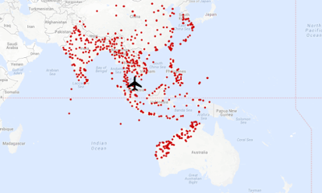
    We can make a pretty good guess at the extent of the primary radar coverage. Here is a map of the airports that have runways long enough for a Boeing 777 can land at:

    801deab3-f236-451e-a486-87b045d0de80-460x276.png

    We can assume that most of these would have primary radar facilities, which would leave very little holes an aircraft could hide in.


  • Closed Accounts Posts: 9,088 ✭✭✭SpaceTime


    Just as a slight aside there are actually Satellite Based Augmentation Systems in place that allow much more detailed satellite tracking of aircraft and the use of GPS for navigation and can even handle approaches to airports without ILS facilities.

    EGNOS - European Geostationary Navigation Overlay Service - Covering EU countries and being built out.

    WAAS - Wide Area Agumentation System - North America.

    MSAS - Multi-functional Satellite Augmentation System - Japan.

    GAGAN - GPS aided geo augmented navigation - India

    The IAA seems to participate in EGNOS : http://www.esa.int/Our_Activities/Navigation/Ireland_now_part_of_Europe_s_first_satellite_navigation_system


    More info + Video:
    http://www.esa.int/Our_Activities/Navigation/The_present_-_EGNOS/What_is_EGNOS

    Just interesting to see the way things are moving with this stuff. It's a shame that similar systems weren't in place for this flight, but the technology is slowly getting there.

    http://www.youtube.com/watch?v=2Xgf0o0ilyo


    Ultimately EGNOS will use both GPS and Galileo for extra back up apparently .. should be interesting times ahead for space-based navigation.


  • Closed Accounts Posts: 3,009 ✭✭✭sopretty


    SpaceTime wrote: »
    Just as a slight aside there are actually Satellite Based Augmentation Systems in place that allow much more detailed satellite tracking of aircraft and the use of GPS for navigation and can even handle approaches to airports without ILS facilities.

    EGNOS - European Geostationary Navigation Overlay Service - Covering EU countries and being built out.

    WAAS - Wide Area Agumentation System - North America.

    MSAS - Multi-functional Satellite Augmentation System - Japan.

    GAGAN - GPS aided geo augmented navigation - India

    The IAA seems to participate in EGNOS : http://www.esa.int/Our_Activities/Navigation/Ireland_now_part_of_Europe_s_first_satellite_navigation_system


    More info + Video:
    http://www.esa.int/Our_Activities/Navigation/The_present_-_EGNOS/What_is_EGNOS

    Just interesting to see the way things are moving with this stuff. It's a shame that similar systems weren't in place for this flight, but the technology is slowly getting there.

    Military departments generally develop these things (in fairness, they have massive budgets). If this stuff is out there, I'd assume it is military who developed the technologies.


  • Closed Accounts Posts: 9,088 ✭✭✭SpaceTime


    sopretty wrote: »
    Military departments generally develop these things (in fairness, they have massive budgets). If this stuff is out there, I'd assume it is military who developed the technologies.

    In this case, it's the European Space Agency (ESA).

    The budget is about €22.2 billion over a 20 year period. Build out cost is estimated at about €5bn but there are a lot of on-going upkeep costs and the figure's probably 'politically sensitive'.

    As this stuff becomes widespread and widely used, incidents like missing aircraft will ultimately become almost impossible as satellite navigation will quite likely be the primary system with primary and secondary radar as the secondary safety system in case of failure.


  • Advertisement
  • Registered Users Posts: 4,746 ✭✭✭irishmover


    sopretty wrote: »
    Military departments generally develop these things (in fairness, they have massive budgets). If this stuff is out there, I'd assume it is military who developed the technologies.

    It's not being developed by military. My old lecturer from Bolton St. (Kevin Mooney) was (May still be not sure) on an advisory team for EGNOS.

    Galileo is taking it's time. It was supposed to be fully operational by now.

    Glonass (Russian) is working fantastically (I use it on a daily basis). Beidou (Chinese) is coming along nicely and then there's other systems like Japan (QZSS) and India (IRNSS).

    Due to America controlling the market (GPS is American) and considering their foul use of selective availability in the 90's and early 00's the more systems we see up in the sky the better. At present I'm more than happy operating via dual systems (Glonass and GPS) and looking forward to seeing more constellations in the sky.

    It's not an easy task to get these systems up and running. But definitely the future of all things navigation is looking bright. No doubt would have been very useful in a situation like this.


  • Registered Users Posts: 210 ✭✭Ballymun Bohs


    Just in relation to that telegraph article on the previous page. Why would they need to blow the cockpit door open if the pilot was allegedly in on the act too?


  • Closed Accounts Posts: 9,088 ✭✭✭SpaceTime


    Galileo isn't expected to be fully operational until 2019.

    Bear in mind the Russian and American systems have been in development since the 1970s. So, they've quite a head-start!

    The big deal with Galileo is that it's a civilian system. The other two have their origins in missile navigation systems.


  • Closed Accounts Posts: 3,009 ✭✭✭sopretty


    Just in relation to that telegraph article on the previous page. Why would they need to blow the cockpit door open if the pilot was allegedly in on the act too?

    For the craic maybe?


  • Registered Users Posts: 4,746 ✭✭✭irishmover


    SpaceTime wrote: »
    Galileo isn't expected to be fully operational until 2019.

    Bear in mind the Russian and American systems have been in development since the 1970s. So, they've quite a head-start!

    It was expected to be 'fully' operational by now. We had a speaker from EGNOS give us a lecture on this back in 2008. I can't remember a GPS/Glonass style fully functionality date persay but I don't recall 2019 being the date. Remember it being a lot sooner than that but could be wrong.

    *Fully in the sense that Survey GNSS units would have been able to use Galileo satellites by 2012. I believe there's 4 satellites up there? I can't quite remember now. Lost a bit of touch with Galileo in the last two years as I'm worried about Australia at present.

    Edit: 4 satellites is bare minimum to provide decent position. X,Y,Z and check = 4 needed but to use for surveying functions it's really not even close.


  • Closed Accounts Posts: 9,088 ✭✭✭SpaceTime


    irishmover wrote: »
    It was expected to be 'fully' operational by now. We had a speaker from EGNOS give us a lecture on this back in 2008. I can't remember a GPS/Glonass style fully functionality date persay but I don't recall 2019 being the date. Remember it being a lot sooner than that but could be wrong.

    *Fully in the sense that Survey GNSS units would have been able to use Galileo satellites by 2012. I believe there's 4 satellites up there? I can't quite remember now. Lost a bit of touch with Galileo in the last two years as I'm worried about Australia at present.

    EGNOS is operational now. It doesn't use Galileo yet though, it effectively enhances GPS by adding ground-based information and relaying it back through the 3 satellites.


  • Registered Users Posts: 4,746 ✭✭✭irishmover


    SpaceTime wrote: »
    EGNOS is operational now. It doesn't use Galileo yet though, it effectively enhances GPS by adding ground-based information and relaying it back through the 3 satellites.

    So VRS? This is nothing new. Trimble/Leica etc. offer this.

    Useful though.

    The lectures and information I've gotten is purely surveying background so I suppose no real place for aviation navigation. I'll bow out of this as Id only add to the confusion.

    But yeh EGNOS is a VRS system on a large scale.


  • Closed Accounts Posts: 9,088 ✭✭✭SpaceTime


    irishmover wrote: »
    So VRS? This is nothing new. Trimble/Leica etc. offer this.

    Useful though.

    The lectures and information I've gotten is purely surveying background so I suppose no real place for aviation navigation. I'll bow out of this as Id only add to the confusion.

    But yeh EGNOS is a VRS system on a large scale.

    Explains a lot without having to delve into ESA websites : http://en.wikipedia.org/wiki/European_Geostationary_Navigation_Overlay_Service - Basically gets you down to aprox 1.5 meter accuracy.


  • Registered Users Posts: 4,746 ✭✭✭irishmover


    SpaceTime wrote: »
    Explains a lot without having to delve into ESA websites : http://en.wikipedia.org/wiki/European_Geostationary_Navigation_Overlay_Service - Basically gets you down to aprox 1.5 meter accuracy.

    Which is pants for surveying (my dual receiver along with VRS/local reference station typically is 28-30mm height), hence where I am is a whole different kettle of fish. So I wouldn't know an awful lot about the aviation side of it. Just the ins and outs of how you get to that level of accuracy.

    But one thing I will add, the massive hole of zero satellites entering north of Ireland will be filled when Galileo comes into full force. Pain in the hole back home at present, quite often found no point in getting lock in Ireland at around midday as the satellites will be terribly placed in the sky. (GPS only reciever)

    So Galileo will definitely benefit northern to north Western Europe.


  • Advertisement
  • Registered Users, Registered Users 2 Posts: 14,343 ✭✭✭✭SteelyDanJalapeno


    Probably has been answered or addressed already, but how in this day and age is there some sort of device powered independently of the planes power system that can send out GPS/location information on planes?


Advertisement