Advertisement
If you have a new account but are having problems posting or verifying your account, please email us on hello@boards.ie for help. Thanks :)
Hello all! Please ensure that you are posting a new thread or question in the appropriate forum. The Feedback forum is overwhelmed with questions that are having to be moved elsewhere. If you need help to verify your account contact hello@boards.ie

Malaysia Airlines flight MH370-Updates and Discussion

Options
1125126128130131219

Comments

  • Registered Users Posts: 1,980 ✭✭✭Growler!!!


    Both Objects said to be 74ft in length.


  • Registered Users Posts: 5,485 ✭✭✭Thrill


    ABC's David Wright - aboard US Navy P-8: radar is getting "hits of significant size" "all indications something down there"


  • Registered Users Posts: 10,179 ✭✭✭✭fr336


    Sigh..I hoped this wouldn't turn out to be the conclusion to this.


  • Registered Users Posts: 4,746 ✭✭✭irishmover


    Malaysia sending 6 ships and three helicopters there...

    Minister for transport to address the media soon aswell.


  • Registered Users Posts: 5,485 ✭✭✭Thrill


    irishmover wrote: »
    Minister for transport to address the media soon aswell.


    Malaysia press conf. It was just cancelled. Don't know why. CNN


  • Advertisement
  • Registered Users Posts: 4,746 ✭✭✭irishmover


    Thrill wrote: »
    Malaysia press conf. It was just cancelled. Don't know why. CNN

    Yeh meant to say malaysian minister for transport.

    Cancelled? I suppose they probably have nothing more to add right now apart from committing resources themselves to this search area.


  • Registered Users Posts: 39,400 ✭✭✭✭Mellor


    @Kay Burley
    #MH370 object 24m long spotted on radar in Southern Indian Ocean. Wing span of 777 is 60m

    Allowing a bit for the body, and a bit of the wing still attach, 24m sounds about right for a wing that's torn off.


  • Registered Users Posts: 13,522 ✭✭✭✭fits


    Just hope the relatives get some answers soon. They are under terrible strain.


  • Registered Users Posts: 4,746 ✭✭✭irishmover


    fits wrote: »
    Just hope the relatives get some answers soon. They are under terrible strain.

    I'm thinking this might be the breakthrough. Why the hell the plane was flying that way most likely won't be known until the black box is found.

    They said that was one of the deepest areas in the South Indian Ocean. I heard 'several thousand feet' anyone got a more definitive value (preferably meters, metric system yo) for the depth in that area? Interesting in relation to locating the black box.


  • Registered Users Posts: 13,522 ✭✭✭✭fits


    The feet and miles thing drives me cracked too. But then I still talk about height and weight in terms of feet and stone so its what you're used to I guess. No idea about depth at that location. I guess they'll need to find debris and determine drift over two weeks etc first.


  • Advertisement
  • Closed Accounts Posts: 12,078 ✭✭✭✭LordSutch


    16,000 to 20,000 thousand feet in the deepest parts I think.


  • Registered Users Posts: 5,485 ✭✭✭Thrill


    Australia's AMSA shares new satellite images of unidentified objects - Object Number 1


    BjJuiRcCYAE8tMs.jpg:large


  • Registered Users Posts: 5,485 ✭✭✭Thrill


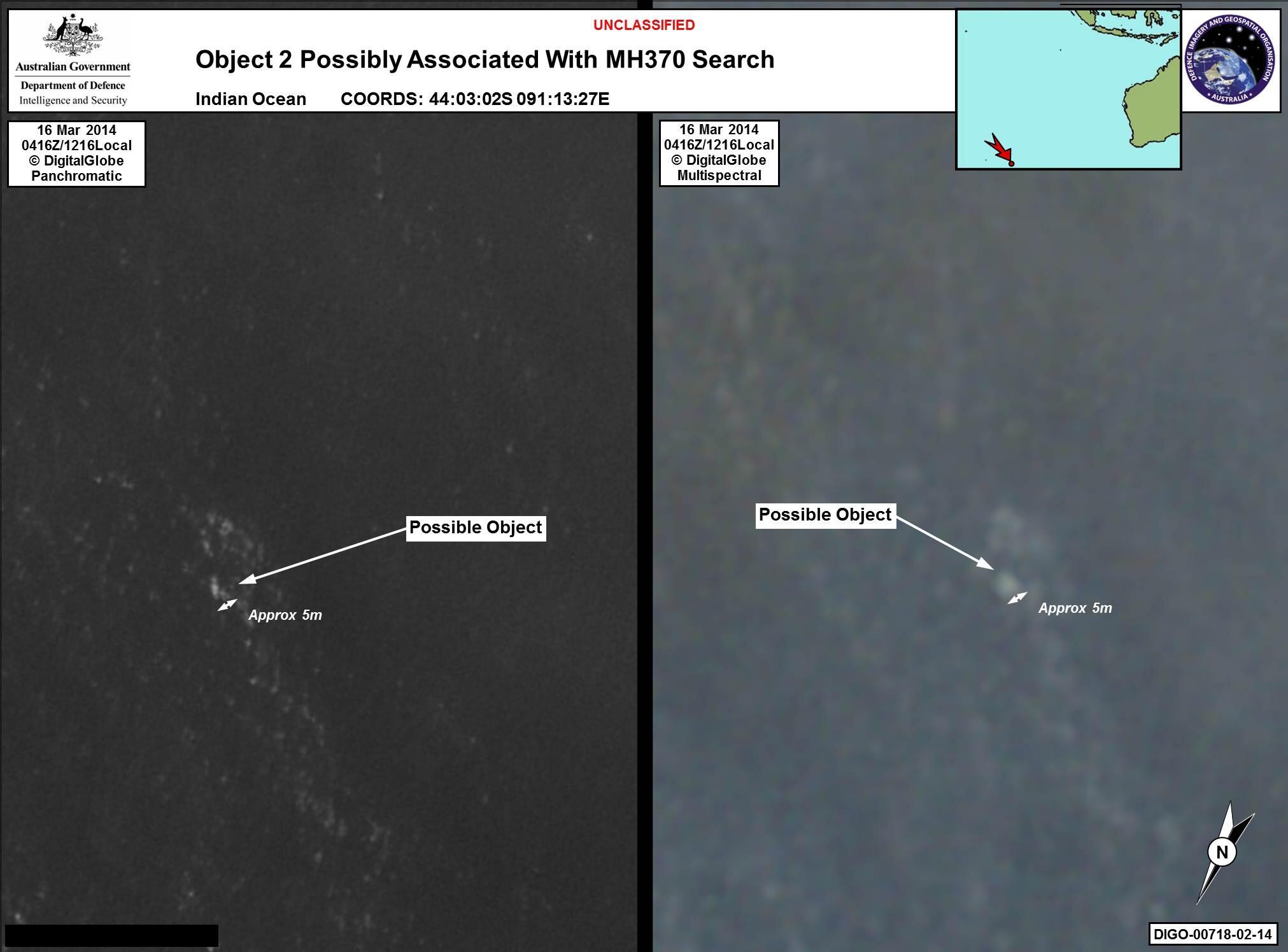
    Australia's AMSA shares new satellite images of unidentified objects - Object Number 2

    BjJuy3QCUAAHS7s.jpg:large


  • Registered Users Posts: 13,522 ✭✭✭✭fits


    If that first object is 24m long then it looks to be 12metres or so wide. That's too wide for aircraft dimensions isn't it?


  • Registered Users Posts: 125 ✭✭arbour


    Thrill wrote: »
    Australia's AMSA shares new satellite images of unidentified objects - Object Number 2

    BjJuy3QCUAAHS7s.jpg:large

    This is dated 16th March. So was taken on Sunday. its 4 days since . I'd be fairly confident that the Australian authorities would only release something like this if they are close to 100% sure it was MH370.


  • Registered Users Posts: 13,522 ✭✭✭✭fits


    It could easily take several days to analyse large swathes of satellite imagery. It is best done manually.


  • Registered Users Posts: 125 ✭✭arbour


    fits wrote: »
    It could easily take several days to analyse large swathes of satellite imagery. It is best done manually.

    Yeah , but they Australians diverted a ship towards the area on Monday which suggests they knew about them then


  • Registered Users Posts: 5,949 ✭✭✭A Primal Nut


    Can't imagine what's going through the relatives mind. This lead may bring finality but on the other hand it would be final confirmation that their relatives are dead. Must be mixed emotions.


  • Registered Users Posts: 180 ✭✭dees99


    Is all the white that you can see in the picture parts of suspected debris? Or is just one piece with rough water around it?


  • Registered Users Posts: 12,778 ✭✭✭✭ninebeanrows


    Ain't convinced about that being it personally. If it is youd wonder how it ended up there!!


  • Advertisement
  • Registered Users Posts: 5,949 ✭✭✭A Primal Nut


    Ain't convinced about that being it personally. If it is youd wonder how it ended up there!!

    If it is it would indicate the plane continued until running out of fuel rather than it being intentionally crashed. Its around the area you would expect it to be if it went south over the indian ocean (which some data indicated) before running out of fuel.

    If it was the pilot who did this he really didn't want people to know he did it I think.


  • Registered Users Posts: 3,748 ✭✭✭Flippyfloppy


    Ah god it's so sad. There was five kids under the age of four on that plane, loads of grandparents as well.


  • Registered Users Posts: 3,135 ✭✭✭flanzer


    While this is the worst possible outcome, I hope it brings closure to the families waiting for their relatives to come back. Particularly some of the relatives of passengers and pilots who were painted as possible terrorists/nut jobs in the media

    The flight path indeed looks like something took the pilots out, until it ran out of fuel, before ditching in the sea. I hope to God that none of the souls suffered.


  • Registered Users Posts: 997 ✭✭✭Colm R


    flanzer wrote: »
    The flight path indeed looks like something took the pilots out, until it ran out of fuel, before ditching in the sea. I hope to God that none of the souls suffered.

    Yeah it looks like the route taken was because the pilots did everything they could to bring the plane down safely, before succumbing to whatever it was that caused them to loose control.


  • Registered Users Posts: 7,401 ✭✭✭Nonoperational


    It would be interesting to find out if the flight was maybe put on that course to avoid harm to people on land if control was hampered...


  • Registered Users Posts: 13,522 ✭✭✭✭fits


    Hey there is nothing confirmed yet. I am very dubious about the dimensions. Can't help feeling the ozzies are jumping the gun a little.


  • Closed Accounts Posts: 18,066 ✭✭✭✭Happyman42


    I wonder was the 'other country' with radar data, Australia? Hope for the families this is it, would just be devastating for another false alarm.


  • Registered Users Posts: 4,746 ✭✭✭irishmover


    fits wrote: »
    Hey there is nothing confirmed yet. I am very dubious about the dimensions. Can't help feeling the ozzies are jumping the gun a little.

    I don't think they're jumping the gun at all. In the AMAS conference they never said it's definitely it. They said it's plausible enough to send resources to that area. It would be careless of them not to pass the information on and commence a search in this area.

    The guys from the geospatial intelligence organisation use satellite imagery regularly to aid with sea searches so they are much more trained than any of us in identifying what is potential debris.


  • Registered Users Posts: 4,746 ✭✭✭irishmover


    Happyman42 wrote: »
    I wonder was the 'other country' with radar data, Australia? Hope for the families this is it, would just be devastating for another false alarm.

    Not sure if I missed something earlier but the two countries with Radar ability heading there were a US plane and an Aussie plane.

    I don't believe that has changed but might have missed something.


  • Advertisement
  • Registered Users Posts: 104 ✭✭notmymark


    irishmover wrote: »
    I don't think they're jumping the gun at all. In the AMAS conference they never said it's definitely it. They said it's plausible enough to send resources to that area. It would be careless of them not to pass the information on and commence a search in this area.

    The guys from the geospatial intelligence organisation use satellite imagery regularly to aid with sea searches so they are much more trained than any of us in identifying what is potential debris.

    You took the words right out of my mouth.


Advertisement