Advertisement
If you have a new account but are having problems posting or verifying your account, please email us on hello@boards.ie for help. Thanks :)
Hello all! Please ensure that you are posting a new thread or question in the appropriate forum. The Feedback forum is overwhelmed with questions that are having to be moved elsewhere. If you need help to verify your account contact hello@boards.ie

Extratropical Storm Ophelia - Technical Analysis Only - MOD NOTE post #1

Options
1575860626389

Comments

  • Registered Users Posts: 6,235 ✭✭✭Oneiric 3


    Latest image. Eye still visible but seems to be fading away over the last while:

    seviri_eurnat_ir10-8_btd_20171015_1000.jpg

    New Moon


  • Registered Users Posts: 8,219 ✭✭✭Gaoth Laidir


    OOZ ECMWF winds for 100 metres. Subtract around 5-10% to estimate surface winds. Force 10 or 11 likely at the surface in souther coastal areas.

    Slight upgrade for the 09Z chart compared to yesterday's chart, showing a Cat 2 purple area inside the Cat 1 gold area south of Ireland.

    ecm0125_nat_100uv_mslp_2017101500_033.jpg

    12Z, the Cat 1 gold area is just on the Cork/Waterford coast.

    ecm0125_nat_100uv_mslp_2017101500_036.jpg

    By 15Z there is a tiny area of Force 12 in Galway bay, but otherwise it's storm force through the rest of the country.

    ecm0125_nat_100uv_mslp_2017101500_039.jpg

    18Z, the southeast and east still getting storm force winds.

    ecm0125_nat_100uv_mslp_2017101500_042.jpg


  • Moderators, Science, Health & Environment Moderators Posts: 11,958 Mod ✭✭✭✭Meteorite58


    Hi Res WRF-NMM 06Z

    Mean

    tempresult_xeo2.gif


    Gust

    tempresult_nuw5.gif


  • Registered Users Posts: 6,175 ✭✭✭munsterlegend


    Hi Res WRF-NMM 06Z

    Mean

    tempresult_xeo2.gif


    Gust


    tempresult_nuw5.gif


    That is again further east.


  • Registered Users Posts: 666 ✭✭✭Full Marx


    How is it looking on the east coast? Louth Meath and Dublin?

    I don't understand these charts at all I'm afraid. Is purple the worst?


  • Advertisement
  • Registered Users Posts: 10,653 ✭✭✭✭MJohnston


    That is again further east.

    It seems to have slightly adjusted back to the track we were seeing on Friday, after moving a touch west yesterday.


  • Registered Users Posts: 8,219 ✭✭✭Gaoth Laidir


    I think Joanna's comment on Cat 2 winds refers to gusts, not sustained winds.

    Again, when looking at NHC figures, subtract around 11% to get Beaufort 10-minute mean speeds.


  • Moderators, Science, Health & Environment Moderators Posts: 11,958 Mod ✭✭✭✭Meteorite58


    That is again further east.

    Yes, ECM seems to have nudged a bit E as well.


  • Registered Users Posts: 6,235 ✭✭✭Oneiric 3


    Met.no (Norway met office) has the storm remaining as a tropical feature as it reaches the SW coast tomorrow, despite having occluded before that:

    met_images.png

    New Moon


  • Registered Users Posts: 10,653 ✭✭✭✭MJohnston


    Full Marx wrote: »
    How is it looking on the east coast? Louth Meath and Dublin?

    I don't understand these charts at all I'm afraid. Is purple the worst?

    They’re pretty simple to read - theres a colour code chart along the bottom with numbers listed in km/h, so the purple is indeed at the higher end of the scale.


  • Advertisement
  • Registered Users Posts: 3,563 ✭✭✭amandstu


    Is it just a coincidence that the eye is forecast to go up the West coast? Does the landmass act as a kind of guide for its (the eye's) course?


  • Registered Users Posts: 8,219 ✭✭✭Gaoth Laidir


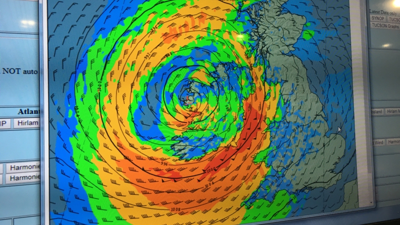
    A sneaky shot of someone at Met Éireann's screen, showing the Harmonie model mean winds. Taken from the RTE website.

    000ec9cb-800.jpg


  • Registered Users Posts: 1,519 ✭✭✭Hooter23


    I think some places that are not in the red alert areas may get some surprises too with squall lines threatening to give severe winds to almost anywhere...


  • Registered Users Posts: 4,805 ✭✭✭thomasj


    amandstu wrote:
    Is it just a coincidence that the eye is forecast to go up the West coast? Does the landmass act as a kind of guide for its (the eye's) course?

    it loses its eye when it becomes a tropical storm


  • Moderators, Science, Health & Environment Moderators Posts: 11,958 Mod ✭✭✭✭Meteorite58


    i7xeuUg.png?1


    XN95Lbp.jpg?1


  • Closed Accounts Posts: 1,576 ✭✭✭patneve2


    The greater Dublin area looks a bit more sheltered compared to other areas in the SW, South and SE although 70 kt gusts still a real possibility. Could be quite nasty with those SSE gusts tomorrow lunchtime - afternoon. Going for a 65-70 kt gust at Dublin airport, so a peak somewhere between 120 and 130 km/h. Unfortunately 80 kt + gusts look quite possible in the most affected areas further south - this could cause some serious damage.


  • Registered Users Posts: 8,219 ✭✭✭Gaoth Laidir


    Core of maximum winds on landfall looks like between Roches Point and Wexford. Key observation stations to watch are Roches Point, Waterford Airport (EIWF) and Johnstown Castle.

    DMK5mruW4AA__qi.jpg


  • Closed Accounts Posts: 6,466 ✭✭✭Lumi


    Mod Note

    This thread is for technical analysis only please - there’s a general discussion thread available for everything else

    Thanks


  • Registered Users Posts: 2,023 ✭✭✭Donegal Storm


    Even if this does take a slight easterly shift there could still be exceptionally strong winds from Kerry up to Galway, ARPEGE model is potentially showing a sting jet close to the centre giving gusts upward of 150kph right across Tralee, Limerick, Ennis and Galway. A sting jet in the Jan'12 storm in Donegal gave gusts of 170kph so potentially even more dangerous than the main band of winds further east

    arpegeuk-11-35-0_slb2.png


  • Registered Users Posts: 8,219 ✭✭✭Gaoth Laidir


    06Z Hirlam, showing Force 11 sustained winds getting into southern Cork/Waterford from around 11 am tomorrow. Peaking at around 60 knots by lunchtime.

    Z2xiSVtukq.gif


  • Advertisement
  • Registered Users Posts: 6,544 ✭✭✭Samaris


    Gaoth Laidir - still getting my head around sting jets. Is that section just to the west of the eye protruding down from north roughly over Galway something along those lines or is it normal swirling winds around the lowest pressure area?


  • Posts: 0 [Deleted User]


    1pm image.

    430642.jpg


  • Closed Accounts Posts: 2,043 ✭✭✭George Sunsnow


    Samaris wrote: »
    Gaoth Laidir - still getting my head around sting jets. Is that section just to the west of the eye protruding down from north roughly over Galway something along those lines or is it normal swirling winds around the lowest pressure area?

    Sting jets wouldn’t be modeled,they are more or less a now cast situation like Squal lines


  • Registered Users Posts: 8,219 ✭✭✭Gaoth Laidir


    Side-by-side comparison of Arpege and Hirlam mean winds tomorrow at 13Z. The bottom right of each image shows the max winds on that chart, so the Arpege shows 66 knots out to sea south of Cork while the Hirlam has 61 knots. A few knots less along the coast in each case.

    23856941958_357d578daf_b.jpg


  • Registered Users Posts: 186 ✭✭shmaupel


    06Z Hirlam, showing Force 11 sustained winds getting into southern Cork/Waterford from around 11 am tomorrow. Peaking at around 60 knots by lunchtime.

    Z2xiSVtukq.gif

    Are the purplish patches that develop around Sligo/South Donegal in the evening time sting jet related?

    Also, a general thank to all who are interpreting these charts for the rest of us. This board is a real gem, we're lucky to have it.


  • Registered Users Posts: 10,653 ✭✭✭✭MJohnston


    shmaupel wrote: »
    Are the purplish patches that develop around Sligo/South Donegal in the evening time sting jet related?

    Also, a general thank to all who are interpreting these charts for the rest of us. This board is a real gem, we're lucky to have it.

    No - the colouring of those charts is really bad, those purple patches are actually at the very low end of the scale, so very low winds.


  • Registered Users Posts: 186 ✭✭shmaupel


    MJohnston wrote: »
    No - the colouring of those charts is really bad, those purple patches are actually at the very low end of the scale, so very low winds.

    Ah thanks. The colours are tricky.


  • Registered Users Posts: 4,786 ✭✭✭Comhrá


    Samaris wrote: »
    Gaoth Laidir - still getting my head around sting jets. Is that section just to the west of the eye protruding down from north roughly over Galway something along those lines or is it normal swirling winds around the lowest pressure area?

    Watch the second part of this video. It gives a good explanation of sting jets:


  • Moderators, Society & Culture Moderators Posts: 1,715 Mod ✭✭✭✭star gazer


    Paully D wrote: »
    Forgive my ignorance, but that image appears to show Ophelia heading more to the west, and not as much to the south-east as I have seen in other models, no?
    Short answer, yes and as it turned out forecasts are for the impact to be a little further East with only small changes having serious potential impact changes locally. The other chart i posted was the track chart, that chart itself shows the probabilities of wind speed which isn't necessarily going to show you the exact track of Ophelia as the winds are biased to the East side.

    This post by sdanseo gives the then position changes in that forecast.
    Current NHC track graphic
    Eye losing distinction
    vis0.gif
    NHC
    WIND: Gale-force winds are expected to begin across southern
    Ireland by early Monday morning and gradually spread northward
    across the country during the day. Hurricane-force winds are
    expected to reach the southern portions of Ireland by Monday
    afternoon and spread inland across the country into Monday night.
    Preparations to protect lives and property should be rushed to
    completion by this afternoon.

    Wind speeds atop and on the windward sides of hills and mountains
    are often up to 30 percent stronger than the near-surface winds
    indicated in this advisory, and in some elevated locations could be
    even greater.

    RAINFALL: Ophelia is expected to produce rainfall amounts of 2 to
    3 inches (50 mm to 75 mm) with isolated totals near 4 inches (100
    mm) through Tuesday across western Ireland and Scotland. Across
    eastern Ireland, rainfall amounts will average around 1 inch (25 mm)
    or less.

    STORM SURGE: A dangerous storm surge is expected to produce
    significant coastal flooding near and to the east of where the
    center makes landfall. Near the coast, the surge will be
    accompanied by large and destructive waves.


  • Advertisement
  • Registered Users Posts: 5,879 ✭✭✭signostic


    Airport TAFS
    Shannon
    TAF: EINN 151100Z 1512/1612 32010KT 9999 BKN012 PROB40 TEMPO 1512/1520 BKN020 TEMPO 1520/1606 3000 -RADZ BR BKN003 BECMG 1601/1604 03015G25KT BECMG 1605/1607 06025G35KT BKN020 BECMG 1609/1612 12035G55KT

    Cork
    TAF: EICK 151100Z 1512/1612 21012KT 2000 -RADZ BKN002 TEMPO 1512/1603 0200 FG -DZ BKN001 PROB30 TEMPO 1512/1521 4000 SCT002 BKN004 BECMG 1518/1520 01005KT BECMG 1603/1606 07020G30KT 9999 NSW SCT025 BECMG 1607/1609 17030G45KT BECMG 1609/1611 17040G60KT

    Ireland West Knock
    TAF: EIKN 151100Z 1512/1612 33010KT 9999 BKN016 PROB30 TEMPO 1512/1514 BKN006 BECMG 1517/1520 01007KT BECMG 1521/1524 -RADZ BKN010 TEMPO 1600/1609 4000 RA BKN004 BECMG 1603/1606 05015G25KT BECMG 1608/1610 08025G35KT BECMG 1610/1612 12030G40KT 9999 NSW SCT025

    Dublin
    TAF: EIDW 151100Z 1512/1612 21013KT 9999 FEW015 BKN018 BECMG 1516/1518 35005KT PROB40 TEMPO 1514/1518 -RADZ BKN014 BECMG 1518/1521 04010KT BKN012 TEMPO 1600/1608 4000 -RADZ BR BKN006 PROB40 TEMPO 1600/1607 2000 BKN003 BECMG 1604/1607 07013KT BECMG 1608/1610 12015G26KT SCT018 BECMG 1610/1612 16025G35KT


    Aldergrove
    TAF: EGAA 151101Z 1512/1612 22015G25KT 9999 BKN012 BECMG 1512/1514 27012KT SCT025 PROB30 TEMPO 1512/1513 6000 -RADZ BKN008 BECMG 1515/1518 36005KT TEMPO 1522/1606 6000 RA -RADZ BECMG 1600/1603 07010KT SCT008 BKN014 BECMG 1603/1606 BKN005 BECMG 1606/1609 11020G30KT SCT025 BECMG 1609/1612 15025G40KT


Advertisement