Advertisement
If you have a new account but are having problems posting or verifying your account, please email us on hello@boards.ie for help. Thanks :)
Hello all! Please ensure that you are posting a new thread or question in the appropriate forum. The Feedback forum is overwhelmed with questions that are having to be moved elsewhere. If you need help to verify your account contact hello@boards.ie

Extratropical Storm Ophelia - Technical Analysis Only - MOD NOTE post #1

Options
1585961636489

Comments

  • Registered Users Posts: 8,219 ✭✭✭Gaoth Laidir


    Latest wind analysis at 12Z, showing max 1-minute winds now dropped to 74 knots. The radius of 64+ winds has further expanded to 65 nautical miles east of centre.

    2017AL17_MPSATWND_201710151200_SWHR.GIF

    Latest water vapour shows it losing all structure now.

    20171015.1245.goes13.x.wv1km.17LOPHELIA.80kts-973mb-401N-169W.80pc.jpg


  • Registered Users Posts: 9,925 ✭✭✭spookwoman


    SAT24 @ 13:55

    q19vGmt.png


  • Registered Users Posts: 8,219 ✭✭✭Gaoth Laidir


    Looks like the NHC have downgraded it to 80 knots now as the 12Z SHIPS forecast below has it initiated at that intensity. It forecasts it to be fully extratropical by 18Z this evening and at around 54 knots intensity by 12Z tomorrow as the centre moves inland over SW Kerry at around 27 knots. In the case of land interaction the LGEM forecast is likely to be more accurate.

    430645.png


  • Registered Users Posts: 154 ✭✭Liffey4A


    What's the expected behaviour of the system now it's losing its structure?
    Its going to interact with colder sea temps now and other systems, will this weaken it or strengthen it as it moves north?


  • Registered Users Posts: 10,632 ✭✭✭✭MJohnston


    Looks like the NHC have downgraded it to 80 knots now as the 12Z SHIPS forecast below has it initiated at that intensity. It forecasts it to be fully extratropical by 18Z this evening and at around 54 knots intensity by 12Z tomorrow as the centre moves inland over SW Kerry at around 27 knots. In the case of land interaction the LGEM forecast is likely to be more accurate.

    Gaoth I know this is obvious to the more technical folks here and the more constant lurkers like myself, but might be worth mentioning when something is and isn't "expected" - I suspect a lot of newbs will read your mention of downgrading and think that applies to the forecast, and not the current conditions.


  • Advertisement
  • Registered Users Posts: 14,450 ✭✭✭✭M.T. Cranium


    I always think Iberia looks like a human face looking west, and today there's quite a sight.

    About the eye disappearing -- more accurate to say that the eyewall structure will dissipate in the transition, an eye will probably remain and continue to contain a zone about 20-30 miles wide where wind speeds fall off to almost zero. Some parts of Connacht (and possibly Kerry/Clare) will experience this tomorrow, it may not move right over a reporting station but we will likely get observations that confirm this.

    Some remnants of the eyewall could be visible for part of the early transition. I have watched several dozen of these storms do a transition over New England or eastern Canada and it takes hours for the eyewall structure to be fully obliterated. Juan 2003 still had the northern half of its eyewall when it made landfall at Halifax despite moving over 15-18 C waters for six hours. We'll see tomorrow if there's much left of that core near Valentia.

    Another thing that seems to happen a lot with landfalling tropical storms or hurricanes is that convective activity will flare near the eventual landfall spot well in advance giving a bit of a "tell" as to where that will be. I think it has to do with electromagnetic currents that are interacting the same way the atmospheric circulations of jet stream and hurricane are interacting. (this is not proven science by the way and in fact I never posted a mention of it anywhere on the internet before today -- MTC's secret recipe).


  • Moderators, Technology & Internet Moderators Posts: 17,133 Mod ✭✭✭✭cherryghost


    ICON Current run vs Previous Run:

    Previous:
    430651.png

    Current:
    430650.png

    Clear eastwards shift noticable, Wicklow looks pretty terrible especially if you live in the mountains. Dublin looks like a noticable upgrade too. Cork still looks pretty bad but Waterford now looks like its in the firing line.

    Wales coast looks dodgy too.


  • Registered Users Posts: 14,450 ✭✭✭✭M.T. Cranium


    Having reviewed a visible satellite loop I would say the storm is still tropical and the eye has reduced in diameter to about 5 miles (current position 40N 16W). It appears to be making the turn north in the last three hours.

    The waters ahead are not all that cold either, near 20 C in Biscay. And the strong southerly flow will bring a slight warming further north.

    This storm may continue to be a hybrid like Sandy up until landfall.

    Storm surge issues should be taken very seriously on this track (from SSW). You know the terrain better than me, but any coastal villages with exposure to the south or southwest may have inundations up to 3 metres above normal high tide and powerful waves could be bringing in debris from beaches.


  • Registered Users Posts: 6,004 ✭✭✭TheMilkyPirate


    160-180km/h gusts in Wexford and Waterford if that icon materialised. I really don't think people understand the severity of this.


  • Registered Users Posts: 8,219 ✭✭✭Gaoth Laidir


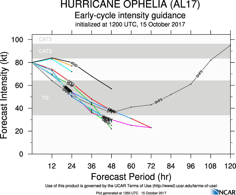
    12Z early intensity forecast, showing it just dipping below Cat 1 by 12Z tomorrow (24 hr). Official NHC forecast is in red. Still Beaufort 10-11 along the south coast with this.

    aal17_2017101512_intensity_early.png


  • Advertisement
  • Closed Accounts Posts: 1,991 ✭✭✭sword1


    Having reviewed a visible satellite loop I would say the storm is still tropical and the eye has reduced in diameter to about 5 miles (current position 40N 16W). It appears to be making the turn north in the last three hours.

    The waters ahead are not all that cold either, near 20 C in Biscay. And the strong southerly flow will bring a slight warming further north.

    This storm may continue to be a hybrid like Sandy up until landfall.

    Storm surge issues should be taken very seriously on this track (from SSW). You know the terrain better than me, but any coastal villages with exposure to the south or southwest may have inundations up to 3 metres above normal high tide and powerful waves could be bringing in debris from beaches.

    When does the surge come, before, during or after the wind. Tides are about a meter below strong tide s. High water around 4 for a lot of cork. Hopefully the surge will hit at low tide


  • Registered Users Posts: 6,167 ✭✭✭munsterlegend


    160-180km/h gusts in Wexford and Waterford if that icon materialised. I really don't think people understand the severity of this.

    I think you had a site for predicting wind strength in a location? Could you post it again thanks?


  • Registered Users Posts: 6,004 ✭✭✭TheMilkyPirate


    I think you had a site for predicting wind strength in a location? Could you post it again thanks?

    Sure,

    https://weather.us/forecast/2960964-wexford/ensemble/euro/wind-gusts


  • Registered Users Posts: 19,306 ✭✭✭✭Drumpot


    Having reviewed a visible satellite loop I would say the storm is still tropical and the eye has reduced in diameter to about 5 miles (current position 40N 16W). It appears to be making the turn north in the last three hours.

    The waters ahead are not all that cold either, near 20 C in Biscay. And the strong southerly flow will bring a slight warming further north.

    This storm may continue to be a hybrid like Sandy up until landfall.

    Storm surge issues should be taken very seriously on this track (from SSW). You know the terrain better than me, but any coastal villages with exposure to the south or southwest may have inundations up to 3 metres above normal high tide and powerful waves could be bringing in debris from beaches.

    Does the storm surge apply to middle/northern east coast ? I am in bettystown and my estate has flooded before in conditions that weren't as bad as this . High tide (due at 10pm tomorrow) followed by prolongued rain caused the problem. I am wondering if my estate needs to be on alert and if we should contact the council!


  • Moderators, Arts Moderators, Recreation & Hobbies Moderators, Social & Fun Moderators Posts: 76,755 Mod ✭✭✭✭New Home


    Reggie. wrote: »
    What is that string of calm wind?

    I don't know, but I assume it's the place where the two weather fronts collide. Anyone with even a scrap more meteorological knowledge than I have will be able to tell you. :)


  • Registered Users Posts: 6,235 ✭✭✭Oneiric 3


    WV animation over the last 12 hrs or so. Gradually losing its 'eye'.

    ani.gif

    New Moon


  • Registered Users Posts: 28,835 ✭✭✭✭_Kaiser_


    Ouch! According to that I can expect 44 mph winds (80mph gusts) from about 12 noon and continuing to be pretty bad until midnight :(


  • Registered Users Posts: 1,518 ✭✭✭Hooter23


    Side-by-side comparison of Arpege and Hirlam mean winds tomorrow at 13Z. The bottom right of each image shows the max winds on that chart, so the Arpege shows 66 knots out to sea south of Cork while the Hirlam has 61 knots. A few knots less along the coast in each case.

    23856941958_357d578daf_b.jpg

    I notice how the first chart has violent winds alot closer to the center of the storm which would put parts of the west in danger as it moves north....


  • Registered Users Posts: 14,450 ✭✭✭✭M.T. Cranium


    goat2 ... your question needs a more precise location but I think the strongest winds at most locations between Bantry Bay and Roches Point will be SSW to SW, from Bantry Bay around to Valentia more of a mix of directions depending on exact track of the centre.

    question about highest storm surge, technically that is the time when water level is displaced highest vs expected from tide tables, but public will perceive it to be at high tide, and in any case it appears that these are similar, IIRC somebody posted them in the 3-4 p.m. range along the south coast.

    Storm surge is likely to peak whenever the centre of the low is to your west and that appears to be 2-3 p.m. for most locations along the south coast.

    It's only about two days to new moon by late Monday, astronomical tides must be fairly close to peak I would imagine within a foot?


  • Closed Accounts Posts: 9,764 ✭✭✭my3cents


    goat2 ... your question needs a more precise location but I think the strongest winds at most locations between Bantry Bay and Roches Point will be SSW to SW, from Bantry Bay around to Valentia more of a mix of directions depending on exact track of the centre.

    question about highest storm surge, technically that is the time when water level is displaced highest vs expected from tide tables, but public will perceive it to be at high tide, and in any case it appears that these are similar, IIRC somebody posted them in the 3-4 p.m. range along the south coast.

    Storm surge is likely to peak whenever the centre of the low is to your west and that appears to be 2-3 p.m. for most locations along the south coast.

    It's only about two days to new moon by late Monday, astronomical tides must be fairly close to peak I would imagine within a foot?

    South coast at Dungarvan they are just over a foot below the highest for the month.

    http://www.ukho.gov.uk/easytide/EasyTide/ShowPrediction.aspx?PortID=0756&PredictionLength=7 (start date is the date you click it so updates).


  • Advertisement
  • Moderators, Science, Health & Environment Moderators Posts: 11,937 Mod ✭✭✭✭Meteorite58


    Mod Note

    This thread is for technical analysis only please - there’s a general discussion thread available for everything else

    Thanks


  • Registered Users Posts: 6,235 ✭✭✭Oneiric 3


    I always think Iberia looks like a human face looking west, and today there's quite a sight.
    this.

    Interesting. Weirdly, I always see Iberia as a face looking south as opposed to west. It's all about personal interpretation I guess. :)

    New Moon


  • Registered Users Posts: 14,450 ✭✭✭✭M.T. Cranium


    Drumpot wrote: »
    Does the storm surge apply to middle/northern east coast ? I am in bettystown and my estate has flooded before in conditions that weren't as bad as this . High tide (due at 10pm tomorrow) followed by prolongued rain caused the problem. I am wondering if my estate needs to be on alert and if we should contact the council!

    See what they're planning for sure, but my estimate for your location would be closer to 1.5 metres and perhaps enough before high tide that it won't be quite as bad as it might be (assuming the time you quote is accurate). Your peak in surge will be around 6 or 7 p.m. while tide is still building so you might just get an early peak and a prolonged high tide that reaches 0.5 to 1.0 metres above expected levels at that point.


  • Registered Users Posts: 2,023 ✭✭✭Donegal Storm


    Nothing on the met website yet but Meteoalarm suggesting that they've issued an orange rainfall warning now as well with 40mm+ possible, Joanna Donnelly said on the farming forecast that they'd be issuing one this afternoon

    http://www.meteoalarm.eu/en_UK/1/0/EU-Europe.html

    Doesn't look like it'll be anything too severe but combined with the winds it'll give very hazardous driving conditions

    arpegeuk-1-34-0_bee2.png


  • Registered Users Posts: 922 ✭✭✭crustybla


    I've been reading the wrong thread for ages, this one if far more interesting.


  • Registered Users Posts: 2,677 ✭✭✭Rougies


    Nothing on the met website yet but Meteoalarm suggesting that they've issued an orange rainfall warning now as well with 40mm+ possible, Joanna Donnelly said on the farming forecast that they'd be issuing one this afternoon

    It's on the MetÉ warnings page.
    STATUS ORANGE

    Rainfall Warning for Connacht, Wexford, Donegal, Clare, Cork, Kerry, Limerick and Waterford


    Heavy rain at times on Monday with some local flooding, especially in coastal areas. 40+ mm possible.
    Issued:
    Sunday 15 October 2017 14:00
    Valid:
    Monday 16 October 2017 09:00 to Monday 16 October 2017 21:00


    STATUS YELLOW

    Rainfall Warning for Dublin, Carlow, Kildare, Kilkenny, Laois, Longford, Louth, Wicklow, Offaly, Westmeath, Meath, Cavan, Monaghan and Tipperary


    Heavy rain at times on Monday with some local flooding, especially in coastal areas. 25 to 40 mm possible.
    Issued:
    Sunday 15 October 2017 14:00
    Valid:
    Monday 16 October 2017 09:00 to Monday 16 October 2017 21:00

    https://www.met.ie/nationalwarnings/default.asp


  • Registered Users Posts: 14,450 ✭✭✭✭M.T. Cranium


    Any further questions about local impacts, post on the other thread, this one should be reserved for more general discussion of the storm. I know it's confusing now that there are level 3 tags on both threads, but I will assist by not answering posts of that nature here, while answering them there (if I can).


  • Registered Users Posts: 12,778 ✭✭✭✭ninebeanrows


    Fairly tight gradient!!

    17101612_1506.gif


  • Moderators, Science, Health & Environment Moderators Posts: 11,937 Mod ✭✭✭✭Meteorite58


    An idea of what gusts could be like tomorrow. Cant get any more of the map on this model.

    3843_kjn6.png

    4585_btc3.png

    6263_vfe6.png


    6041_vkw8.png


  • Advertisement
  • Registered Users Posts: 17,797 ✭✭✭✭hatrickpatrick


    Anyone who doesn't read Jeff Masters' blog at Weather Underground should start doing so now, he gives an incredible in-depth analysis of the science behind these events and unlike most websites, the comments section tends to be full of weather enthusiasts who know what they're talking about like here, as opposed to mindless political crap.

    https://www.wunderground.com/cat6/ophelia-hits-category-3-destructive-winds-tap-ireland

    I would also highly recommend NCHurricane2009's comments, as he goes into the wider atmospheric context which gives rise to tropical storms each day, and has correctly called many tropical waves over the years as future hurricanes days before they have been picked up by the NHC:

    https://disqus.com/by/nchurricane2009/


Advertisement