Advertisement
If you have a new account but are having problems posting or verifying your account, please email us on hello@boards.ie for help. Thanks :)
Hello all! Please ensure that you are posting a new thread or question in the appropriate forum. The Feedback forum is overwhelmed with questions that are having to be moved elsewhere. If you need help to verify your account contact hello@boards.ie

Bike Navigation...

Options
  • 09-11-2017 8:59am
    #1
    Registered Users Posts: 7,741 ✭✭✭


    Just wondering how people find their way around without using their brains? I need to get around Dublin mostly, then Ireland and possibly some light touring in Europe...
    1. Strap my phone to the handlebars
    2. Get a smart watch
    3. Get a Garmin or Tom Tom
    4. Tom Tom do a scooter nav...

    Honestly, I'm really tempted by the scooter navigation jobby... has full Euro maps for life for free... and I don't need anything too complex or with lots of features... just simple, readable maps...

    https://www.tomtom.com/en_gb/sat-nav/scooter-sat-nav/

    Just wondering what everyone is using and what are the pro's/con's


Comments

  • Registered Users Posts: 13,381 ✭✭✭✭Paulw


    I use my phone, in a tankbag, which is visible, and then bluetooth audio directions in my helmet.

    I could buy a cradle for the phone and mount it above my instrument panel, but that just seems like more hassle than it's worth.


  • Registered Users Posts: 2,949 ✭✭✭fdevine


    My setup, for when I need it, is similar to Paulw - use Google Maps on the phone connected to Bluetooth on the helmet

    If you need the phone visible there are various options - mounted waterproof case, a tank/tunnel bag or maybe one of those neoprene phone cases


  • Registered Users Posts: 2,869 ✭✭✭thegreatiam


    waterproof phone + ram mount bluetooth to head set, worked well until a recent heavy rain driving through an unfamiliar city and the rain kept messing with the touch screen.

    before that, non waterproof phone and a joggers arm strap tied in the middle of the handlebar with zip ties.


  • Registered Users Posts: 1,936 ✭✭✭stewygriffin


    I will post a cheap how to with pics later on.
    Never once let me down in the UK and Germany.


  • Registered Users Posts: 14,296 ✭✭✭✭Cienciano


    I used to have a garmin zumo but tbh I wouldn't touch one again, google maps on the phone is 100 times better. I'd use some sort of phone setup and if you're going to be in mountainous areas where you might get no coverage, just download areas for offline use before you set off.


  • Advertisement
  • Registered Users Posts: 699 ✭✭✭landmarkjohn


    Google maps on the phone.

    My Otterbox Defender case came with a hard plastic belt clip/bracket. I tie wrapped and velcro'd (belt and braces :D ) this to the the handlebar cross piece (GS) and it works OK in the dry. Bit of a nuisance if you get a notification on the screen and not waterproof.

    My biggest problem is walking away from the bike with an easily removable iPhone clipped to it :eek:


  • Registered Users Posts: 574 ✭✭✭thos


    I was hoping to go same phone with Waze/Google Maps, but mount the Givi holder/mount I got is kind crap. I've got a Triump Tiger and the intrstruments are kinda far forward, but when the phone is mounted on the handlebars it's almost like it's in your face, have to pull back to get a proper look, so that's not gonna work for me, need a better mount.


  • Registered Users Posts: 8,053 ✭✭✭BKtje


    I have a garmin motorbike gps and works a treat. Pricey though.


  • Closed Accounts Posts: 24,878 ✭✭✭✭arybvtcw0eolkf


    I still write directions on paper, in a zip lock and taped to the tank/fairing lol.


  • Registered Users Posts: 33,983 ✭✭✭✭listermint


    I drive around till I find where I'm going :)


  • Advertisement
  • Registered Users Posts: 7,882 ✭✭✭frozenfrozen


    Same, sometimes I write it down and put it in a sandwich bag and magnet it onto the tank, other times I'll just look at the route beforehand and try to memerise a few names / waypoints and I'll always get there

    I'm very bad at navigating through cities through. I have sygic on my phone but no way to mount it and will eventually get a tank bag with a window.

    the heads up display mode is good because you don't need to look at a map it just shows an arrow on a black background. Never used it on the bike yet but have in the car and it's good.. all offline maps

    05_screen_desktop.png it doesn't need to project onto something thats just for in cars you can look at it normally too

    it also costs money.. I didn't pay money for it...


  • Registered Users Posts: 1,936 ✭✭✭stewygriffin


    Flexi waterproof holder for 10 euro off ebay China.
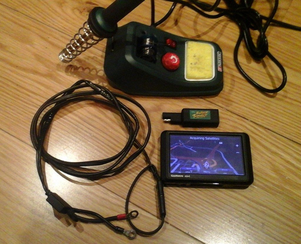
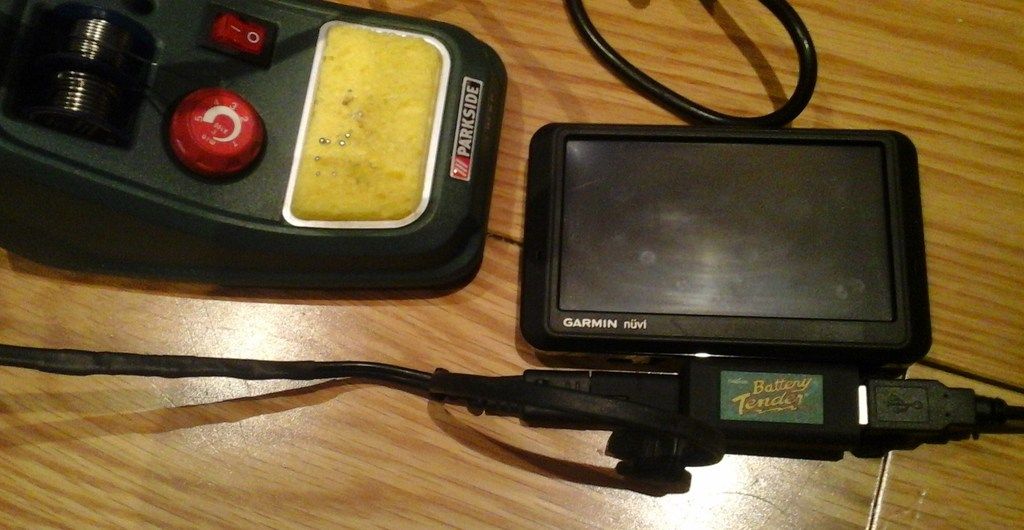
    10 year old Garmin Nuvi satnav with maps upgrade,MP3 player,stereo jack and bluetooth for listening to music and map instructions at the same time.Home made SAE battery lead with 3 amp fuse. And a USB connector to finish things off.
    Simples.

    20170721_080423_zpsjjimkx2e.jpg

    20170414_115347-1_zps8spgykka.jpg

    20170427_150056-1_zps5bl6jobj.jpg


  • Registered Users Posts: 1,936 ✭✭✭stewygriffin


    And the home made SAE battery lead too.

    20160330_214137_zps49sqhzxr.jpg

    20160330_214943_zpswpo2mcag.jpg


  • Registered Users Posts: 19,663 ✭✭✭✭Muahahaha


    none of those pics are displaying stewy


  • Registered Users Posts: 1,936 ✭✭✭stewygriffin


    Muahahaha wrote: »
    none of those pics are displaying stewy

    Ah thats a bummer,I can see the pics myseif,but I had to do the "photobucket fix" that Riva explained about in the other thread.:)


  • Registered Users Posts: 7,741 ✭✭✭Bluefoam


    Ah thats a bummer,I can see the pics myseif,but I had to do the "photobucket fix" that Riva explained about in the other thread.:)


    I did that fix too, but it's still not working


  • Registered Users Posts: 1,936 ✭✭✭stewygriffin


    Pics attached.:)


Advertisement