Advertisement
If you have a new account but are having problems posting or verifying your account, please email us on hello@boards.ie for help. Thanks :)
Hello all! Please ensure that you are posting a new thread or question in the appropriate forum. The Feedback forum is overwhelmed with questions that are having to be moved elsewhere. If you need help to verify your account contact hello@boards.ie

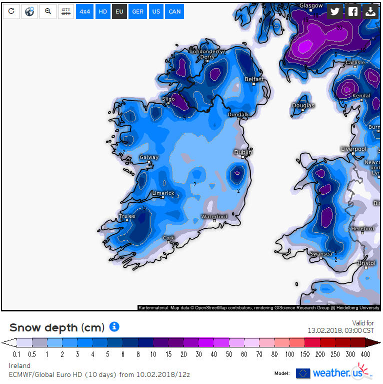
Saturday PM (10th) - Tuesday AM (13th), Snow and Ice

Options
1235735

Comments

  • Registered Users Posts: 769 ✭✭✭davidsr20


    Very windy here east galway.


  • Registered Users Posts: 10,649 ✭✭✭✭MJohnston


    There's a handy site here that decodes the TAFs into proper sentences, instead of the coded stuff that takes 2 hours to figure out:
    http://en.allmetsat.com/metar-taf/united-kingdom-ireland.php?icao=EIDW

    You can click on the map to get the different airports.


  • Registered Users Posts: 18,169 ✭✭✭✭JCX BXC


    The Aeroweather (actually think it's been renamed Pilot Weather) app is very good and update very quickly. Have been using it the last 2-3years.


  • Registered Users Posts: 9,233 ✭✭✭sdanseo


    I think posting TAFs in future should have explanations in English for those who won't be able to read them. Make it easier for onlookers to understand.

    Perhaps a sticky or item in the useful links thread with a decoding tool, maybe a link that same provided with TAF posts?

    If you sit down for 10 mins it is very easy to learn how decode them. Happy to provide as much explaining as needed but such a long winded explanation in every post where the report, especially the full TAF, is posted would be a bit long winded.


  • Registered Users Posts: 8,219 ✭✭✭Gaoth Laidir


  • Advertisement
  • Registered Users Posts: 8,219 ✭✭✭Gaoth Laidir


    sdanseo wrote: »
    Perhaps a sticky or item in the useful links thread with a decoding tool, maybe a link that same provided with TAF posts?

    If you sit down for 10 mins it is very easy to learn how decode them. Happy to provide as much explaining as needed but such a long winded explanation in every post where the report, especially the full TAF, is posted would be a bit long winded.

    Exactly. No need to decode the whole lot if only part of it is relevant and is explained.


  • Registered Users Posts: 9,233 ✭✭✭sdanseo


    The coldest uppers will have passed east by then. Increasing heights and temperatures will cut down showery activity. Tomorrow morning 0600-1200 is the best window.

    A couple of the pub runs showing the -8's sticking around later, but precip dying out by late afternoon

    HIRLAM

    hirlamuk-16-24-0.png?10-22

    hirlamuk-1-21-0.png?10-22

    hirlamuk-1-27-0.png?10-22

    GFS, -8's present until midnight or after

    27-7UK.GIF?10-18

    precip at 1600Z

    21-779UK.GIF?10-18

    showers dying out by 2200Z
    27-779UK.GIF?10-18


  • Registered Users Posts: 10,649 ✭✭✭✭MJohnston


    GFS' lack of resolution really makes it useless at accurate precip charts closer than 36 hours.


  • Registered Users Posts: 23,676 ✭✭✭✭Kermit.de.frog


    sdanseo wrote: »
    explanation in every post where the report, especially the full TAF, is posted would be a bit long winded.

    There is no requirement whatsoever to be posting full TAFs here. Not only is it pointless given the model data available but onlookers should not have to be doing any research to simply be able to find out what the forecast is.

    Best to keep things as simple as possible. I'd recommend opening a thread for TAFs and dump them in there for those interested.


  • Registered Users Posts: 13,589 ✭✭✭✭sryanbruen


    There is no requirement whatsoever to be posting full TAFs here. Not only is it pointless given the model data available but onlookers should not have to be doing any research to simply be able to read them.

    Best to keep things as simple as possible. I'd recommend opening a thread for TAFs and dump in there for those interested.

    I think we have enough threads :).


  • Advertisement
  • Registered Users Posts: 2,360 ✭✭✭lolie


    A few very wet small flakes of snow in the last shower that passed through here in s cavan.


  • Registered Users Posts: 18,169 ✭✭✭✭JCX BXC


    Best to keep things as simple as possible. I'd recommend opening a thread for TAFs and dump in there for those interested.

    And we'll open separate threads for reports, separate threads for wind charts, separate threads for temp charts, separate threads for everything!

    If it's relevant why not post them?


  • Registered Users Posts: 9,233 ✭✭✭sdanseo


    There is no requirement whatsoever to be posting full TAFs here. Not only is it pointless given the model data available but onlookers should not have to be doing any research to simply be able to find out what the forecast is.

    Best to keep things as simple as possible. I'd recommend opening a thread for TAFs and dump them in there for those interested.

    I think GL's approach is reasonable here. A TAF is one line, 2 max, of text on a large monitor.

    A decoded TAF is many lines.

    However, a TAF with relevant bits in bold and explained is maybe 2/3 lines and a happy medium. It's certainly no more obtrusive than the many hundreds of 800x600 chart pictures in the thread, which not everyone is an expert at reading either.

    Example:
    EIDW 101700Z 1018/1118 21020G30KT 9999 BKN025 TEMPO 1018/1020 24027G44KT -RA BKN010 BECMG 1019/1021 28027G40KT BECMG 1023/1101 28020G30KT BECMG 1103/1106 26018KT PROB40 TEMPO 1112/1118 28020G30KT 5000 -SHGS BKN012 SCT018CB

    40% chance of light graupel tomorrow, 1200-1800Z


  • Registered Users Posts: 2,677 ✭✭✭Rougies


    There is no requirement whatsoever to be posting full TAFs here. Not only is it pointless given the model data available but onlookers should not have to be doing any research to simply be able to find out what the forecast is.

    Best to keep things as simple as possible. I'd recommend opening a thread for TAFs and dump them in there for those interested.

    Have to disagree here Kermit, I don't think they're pointless at all as they are a professional forecast and will also take into account things we don't have access to like the Harmonie model.


  • Registered Users Posts: 10,135 ✭✭✭✭Oscar Bravo


    There is no requirement whatsoever to be posting full TAFs here. Not only is it pointless given the model data available but onlookers should not have to be doing any research to simply be able to find out what the forecast is.

    Best to keep things as simple as possible. I'd recommend opening a thread for TAFs and dump them in there for those interested.

    Nah, love the TAF'S, we will keep them thanks.


  • Registered Users Posts: 23,676 ✭✭✭✭Kermit.de.frog


    JCX BXC wrote: »
    And we'll open separate threads for reports, separate threads for wind charts, separate threads for temp charts, separate threads for everything!

    If it's relevant why not post them?

    I have no problem at all with them being posted so long as they are explained for those who can not read them.

    I think they are totally pointless. And yet we have them on almost every page from certain posters who clearly can't be bothered looking at the models. The model data is there.

    [ Mod Snip]


  • Registered Users Posts: 699 ✭✭✭bazlers


    Seemingly around the middle of March 1979 in the Edenderry area there was at least 30CMs of level snow on the ground. There was no snow at all in tullamore. So quiet a localised event.


  • Registered Users Posts: 10,649 ✭✭✭✭MJohnston


    I've never found the TAFs particularly good in forecast terms, they're often conservative, but they're certainly useful for current observations.


  • Closed Accounts Posts: 2,043 ✭✭✭George Sunsnow


    Maybe we should open a separate thread on the merits of taf’s first rather than derailing this one with more balderdash argey bargey?

    OR

    I would suggest just referring to them in comoner garden language as ‘the latest xxx airport area forecast ‘ is... and say what that is
    Passing visitors,the bulk of the threads traffic and the people the thread is for have no interest in argey bargey and just want to know if it’s going to snow,gale or flood ,strike with lightning etc


  • Registered Users Posts: 18,169 ✭✭✭✭JCX BXC


    I have no problem at all with them being posted so long as they are explained for those who can not read them.

    I think they are totally pointless. And yet we have them on almost every page from certain posters who clearly can't be bothered looking at the models. The model data is there.

    It's spamming.

    Ah here get off it will ya - "certain posters who clearly can't be bothered looking at the models".

    You've great contributions Kermit but seriously?


  • Advertisement
  • Closed Accounts Posts: 6,466 ✭✭✭Lumi


    Mod Note

    The forum moderators have no issue with TAFs being posted so long as they are decoded so that everyone can follow the thread.
    We have already communicated this to the couple of posters who use them and by and large they have complied with the request to decode them.

    Can we get back on topic please?

    Thanks


  • Closed Accounts Posts: 1,312 ✭✭✭Nettle Soup


    So much tension with the anticipation of white gold ;)


  • Registered Users Posts: 2,941 ✭✭✭JanuarySnowstor


    I have to agree with Kermit and find them rather pointless. The data we have access to is far better.
    By the way I often read how useless gfs ppn charts are. I wonder can these one liners be supported because I find them very accurate.
    In general I'm a big fan of the gfs anyway and think the slating it gets on other forums is quite close to a disgrace


  • Registered Users Posts: 24,026 ✭✭✭✭Larbre34


    All this thread starting is going to KdF's head methinks.

    You're a regular poster who just appears to have more time on his hands than some of the rest of us. The TAFs stay.


  • Registered Users Posts: 9,233 ✭✭✭sdanseo


    Looking a little ahead to Monday night:

    e02e872e30db601143381c035b255cad.png
    nmmuk-26-62-0.png?10-19
    nmmuk-26-61-0.png?10-19
    iconeu_uk1-46-62-0.png?10-16


  • Moderators, Science, Health & Environment Moderators Posts: 11,948 Mod ✭✭✭✭Meteorite58


    Larbre34 wrote: »
    All this thread starting is going to KdF's head methinks.

    You're a regular poster who just appears to have more time on his hands than some of the rest of us. The TAFs stay.

    Mod Note: Laerbre34 has received a warning for personal abuse. Need to get back on topic.


  • Registered Users Posts: 679 ✭✭✭eastmayo


    Snowing heavy here at the moment. Kilmovee mayo.


  • Registered Users Posts: 2,164 ✭✭✭PukkaStukka


    Folks, I'm not a mod and I have the passion about weather as everyone else here. I also value everyone's contribution be they amateur, pro, anorak or whatever. Each to their own as they say, but at the same time, the level of respect that has generally been shown to one another is one of the things which makes this particular forum to be as enjoyable as it is.

    Can I say therefore, please, that we don't fall out among ourselves. We actually have a good thing going here :)


  • Registered Users Posts: 10,649 ✭✭✭✭MJohnston


    By the way I often read how useless gfs ppn charts are. I wonder can these one liners be supported because I find them very accurate.

    I said that myself, and what I mean is that the actual mapping resolution of the charts is too low to be very useful. It's 0.25 degrees, so approximately each 'square' of the model is about 27km in width. Which means you often get Dublin indicated as having snow when it really only means it'll fall over the mountains and higher ground. Similar in other parts of the country which are near high ground. And it's not great at estimating coastal effects because of this either.

    Compare with say the WRF, which I don't know about the relative accuracies of the models, but the resolution is literally about 10 times better there (2km vs 27km), and so you get a better representation of the localised effects of snow.

    Other short-range models like HIRLAM or ARPEGE are 0.1 degrees (about 11km), or there's the 7km ICON, or the 1.3km AROME.

    So, imo, it's not about the GFS modelling precip incorrectly, it's about how specific it can get for the differentiation between snow and rain. The charts might be 100% spot on, but they're just not high-res enough to show local effects.

    In addition to the above, I would say that the GFS is very useful in the medium-range for precipitation estimation, because it gives good generalised pictures of the weather we can expect, but once those short-range models come into view at around 36 hours out, you're better off switching to them for a clearer picture of how the precip will fall.


  • Advertisement
  • Registered Users Posts: 8,219 ✭✭✭Gaoth Laidir


    The latest satellite shows colder cloud tops just arriving in the northwest now. Temps and dewpoints still pretty high in general.

    https://weather.us/satellite/europe/top-alert-15min/20180210-2230z.html

    PS. I will continue to post whatever TAFs I want, explaining where needed. If someone doesn't want to read them then just scroll on past. Nobody has the right to dictate what others should or should not post just because that person started the thread. In many cases TAFs are more valuable than some of the GFS precip charts that fill up pages and pages of the threads. To say that whoever posts TAFs couldn't be bothered to look at the models is pretty lame. Go and read up on TAFs if you don't understand them or read the explanation that invariably accompanies them.


This discussion has been closed.
Advertisement