Advertisement
If you have a new account but are having problems posting or verifying your account, please email us on hello@boards.ie for help. Thanks :)
Hello all! Please ensure that you are posting a new thread or question in the appropriate forum. The Feedback forum is overwhelmed with questions that are having to be moved elsewhere. If you need help to verify your account contact hello@boards.ie

Galway traffic

Options
1113114116118119253

Comments

  • Registered Users Posts: 3,387 ✭✭✭xckjoo


    Six months!!! How the hell can that take six months???
    Seems like a reasonable time frame for a decent sized development


  • Posts: 0 [Deleted User]


    Well it's already a year (or more?) under construction! Mostly just loading the soft ground in the middle of the roundabout with stone so it doesn't sink when the road is constructed. Hopefully it's settled - serious mound on it now!

    Also work is due to he finished in 6 months, might not get going again for a couple of months yet.


  • Posts: 0 [Deleted User]


    Six months!!! How the hell can that take six months???

    No doubt they could do it a lot faster if they closed the junction.

    All of these RAB conversions were slow to do due to keeping FULL access for vehicles on ALL routes.

    Next up, the Browne or Martin RAB, not sure which, but expect it to take a long time too.

    I think Browne is needed for the GTS corridor, I'm not sure. If thats the case, that will likely be next


  • Registered Users Posts: 4,955 ✭✭✭what_traffic


    Next up, the Browne or Martin RAB, not sure which, but expect it to take a long time too.

    I think Browne is needed for the GTS corridor, I'm not sure. If thats the case, that will likely be next

    It will be Martin (Galway Clinic) next, money is in place for it(from a Urban Regeneration Fund no less), detailed plans are drawn up for it.

    After that could be 50/50 toss up between the GMIT and Browne(behind UHG)?
    Both are on the spine of the GTS corridor
    The Browne and the GMIT one should have really been the first ones to be converted if the intention was to improve the lot of people who walk and cycle considering the locations.:rolleyes:


  • Registered Users Posts: 24,799 ✭✭✭✭zell12


    ..The Browne and the GMIT one should have really been the first ones to be converted if the intention was to improve the lot of people who walk and cycle considering both there locations.:rolleyes:
    That Browne roundabout is abysmal for pedestrians, as motorists floor the accelerator from the previous lights. Pedestrians have to literally plead with motorists to be allowed to walk.


  • Advertisement
  • Registered Users Posts: 25,902 ✭✭✭✭Mrs OBumble


    zell12 wrote: »
    That Browne roundabout is abysmal for pedestrians, as motorists floor the accelerator from the previous lights. Pedestrians have to literally plead with motorists to be allowed to walk.

    Agree its abysmal.

    But plead? Nope. Just wait patiently, and a suitable break in the traffic ALWAYS happens.

    My worse experiences were with the former RAB near HP. A "nice" (stupid) motorist stopped to let me cross, and practically got rear-ended: if he had then it would have become a many vehicle very quickly. Was very glad when that one was removed, as I was crossing it twice daily.


  • Posts: 0 [Deleted User]


    zell12 wrote: »
    That Browne roundabout is abysmal for pedestrians, as motorists floor the accelerator from the previous lights. Pedestrians have to literally plead with motorists to be allowed to walk.

    I think that is the norm rather than the exception with RAB's in general


  • Posts: 0 [Deleted User]


  • Registered Users Posts: 4,695 ✭✭✭serfboard


    This will be a great addition
    I've seen that mockup before, and it's a class design. Iconic, much as the original one was. Can't come soon enough.


  • Registered Users Posts: 24,799 ✭✭✭✭zell12


    But what about de anti-social and de ne'er do wells that the saintly yacht club yelled about using it


  • Advertisement
  • Registered Users Posts: 3,284 ✭✭✭dubhthach


    Only taken about 30 years for them to get the finger out, been at least 3 proposals since mid 80's to do that. Still here's hoping it actually gets the funding.


  • Registered Users Posts: 5,216 ✭✭✭bobbyss


    Anybody know what was happening on SQ Road from hospital all up to Westside S Centre on Thursday about 4 pm? No movement. Am not usually there at tha time but is it like that regularly? Couldn't believe it.


  • Registered Users Posts: 24,799 ✭✭✭✭zell12


    bobbyss wrote: »
    Anybody know what was happening on SQ Road from hospital all up to Westside S Centre on Thursday about 4 pm? No movement. Am not usually there at tha time but is it like that regularly? Couldn't believe it.
    Pre-Covid normal traffic scenario returning
    Sure the buses, cycles, pedestrians whizzed by :D


  • Registered Users Posts: 4,955 ✭✭✭what_traffic


    zell12 wrote: »
    But what about de anti-social and de ne'er do wells that the saintly yacht club yelled about using it

    Yup, could have had this bridge decades ago only for this


  • Registered Users Posts: 4,955 ✭✭✭what_traffic


  • Posts: 0 [Deleted User]


    Changes proposed for Oranmore Village, full details at the links.

    Details on the full submission and the group involved - https://moraction.blogspot.com/

    Oranmore campaign group submits proposal for one-way system to Galway County Council

    https://galwaybayfm.ie/galway-bay-fm-news-desk/oranmore-campaign-group-submits-proposal-for-one-way-system-to-galway-county-council/

    A campaign group has submitted its proposal to Galway County Council for a trial of a one-way system in Oranmore.


  • Posts: 0 [Deleted User]


    The submission related to the above post is attached here for convenience


  • Registered Users Posts: 25,902 ✭✭✭✭Mrs OBumble


    zell12 wrote: »
    But what about de anti-social and de ne'er do wells that the saintly yacht club yelled about using it

    It looks to me like The Line part 2. Not sure how it can be made safe.


  • Registered Users Posts: 4,955 ✭✭✭what_traffic


    It looks to me like The Line part 2. Not sure how it can be made safe.

    People and usage will it make safe, big student accommodation is proposed to go in opposite ARGOS + City Council owned Dyke Road Car Park area is also a lager underutilized area for Development so close to the City Centre.


  • Registered Users Posts: 4,955 ✭✭✭what_traffic


    It looks to me like The Line part 2. Not sure how it can be made safe.

    Ya have point though. Should it be built now or wait....
    This NEW pedestrian and cyclist bridge on the old Railway piers would not be top of my list at all to improve the lot of people who walk and cycle in the City.
    The big projects will always make the headlines


  • Advertisement
  • Posts: 0 [Deleted User]


    It really is a case of "if you build it, they will come" but this time, instead of induced demand with private cars, we're talking about bikes

    https://www.theguardian.com/lifeandstyle/2021/mar/12/europe-cycling-post-covid-recovery-plans

    The numbers are remarkable
    • 1 billion spent
    • Nearly 1,000km's of new bike infrastructure
    • Massive increase in women cycling
    • In a survey spanning 21 European cities, 64% of respondents said they did not want to return to pre-Covid air pollution levels, which are illegally high in many cities. Three-quarters were willing to reallocate public space from cars to active travel to achieve this, while 21% said they planned to cycle more after lockdown, and 35% planned to walk more.

    The impact has been even more remarkable
    • Barcelona is aiming for a 300km bike network by 2024 as recent investment has grown bike use to 10% beyond pre-pandemic usage
    • Milan’s Strade Aperte programme was launched in April 2020 with a proposed 22 miles of new protected cycle lanes and pedestrian priority areas. The cycle route on Corso Buenos Aires is now the busiest in town, used by as many as 10,000 cyclists a day, an increase of 122% in a few months. Milan has now expanded Strade Aperte to 42 miles and is aiming for 62 miles by this summer.
    • Paris, cycling has grown by 70% due to 50km of lanes installed early in the pandemic. Plans for a total of 200km of infrastructure are progressing.
    • Lisbon is doubling its network from 100 to 200km. Cycling has grown by 25%.
    • London has installed or started work on 62 miles of cycle routes since the start of the pandemic, and Transport for London data from January shows cycling has increased by 22% in outer London since 2019. Almost half of all journeys in London were made by cycling and walking from April to June 2020, up from 29% before the pandemic.
    • Brussels trialled 37 miles of pop-up cycle routes in 2020, increasing “active cyclists” by 87%, and Belgium is now looking to extend its cycle highway plans between towns and cities.
    • Krakow installed a handful of cycle paths that doubled cycling levels last summer, with many people switching from public transport to bikes. The city has now developed a five-year plan to expand the cycle network further.

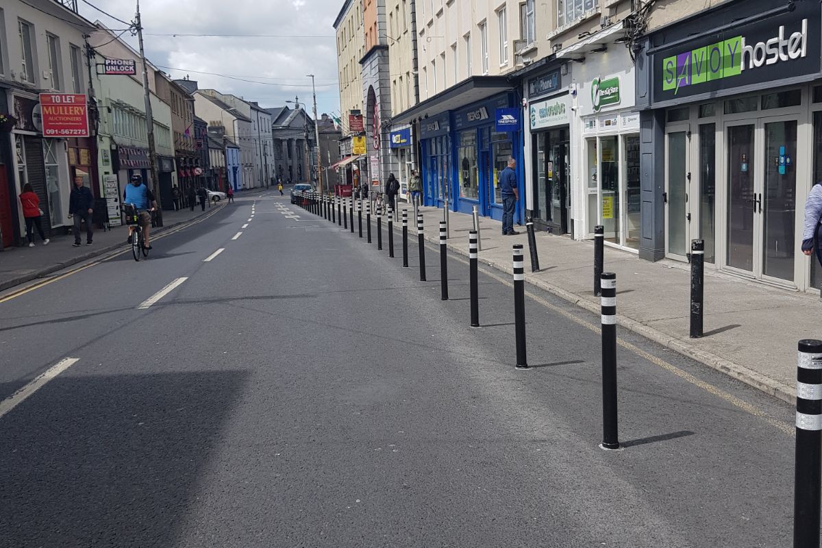
    Meanwhile in Galway, we get a protected bit of road that cyclists are not allowed into

    Pedestrian-Galway-2.jpg


  • Registered Users Posts: 3,252 ✭✭✭ratracer


    The submission related to the above post is attached here for convenience

    Although I’d normally be in favour of trialling new things, I don’t think the design of the road around the back of the village via Aldi and Tesco is a good enough standard for increased traffic. The 90 degree bends already on that road are a disaster, how the were deemed safe at the design/ planning stage is unbelievable. Something needs to be done though, as going through the village is a danger to all modes of transport, primarily as a result of illegal parking and poor layout of on-street parking.


  • Registered Users Posts: 1,591 ✭✭✭Laviski


    Meanwhile in Galway, we get a protected bit of road that cyclists are not allowed into

    If i recall that was for pedestrians in light of the current health situation the world finds itself in, you will (cyclists) have it more or less to yourselves when the road becomes bus lane only. (apart of the 4 hours or so to allow deliveries.)


  • Posts: 0 [Deleted User]


    Laviski wrote: »
    If i recall that was for pedestrians in light of the current health situation the world finds itself in, you will (cyclists) have it more or less to yourselves when the road becomes bus lane only. (apart of the 4 hours or so to allow deliveries.)

    I'm fully aware and to be honest, I call bullcrap.

    There are plenty of other narrower footpaths all around the city where they didn't do a thing. If they were serious about facilitating space for pedestrians, there would be virtually zero on street parking left in Galway


  • Registered Users Posts: 1,591 ✭✭✭Laviski


    well councillors won't increase the ltp, stuff needs to be paid for.
    Wont fully defend the council as some of their decisions feels like they are immatation of an elon musk and joe rogan discussion, but like every person you need to balance the books.

    you happy with higher taxes?


  • Posts: 0 [Deleted User]


    Laviski wrote: »
    well councillors won't increase the ltp, stuff needs to be paid for.
    Wont fully defend the council as some of their decisions feels like they are immatation of an elon musk and joe rogan discussion, but like every person you need to balance the books.

    Millions extra has been provided to councils all over the country to specifically provide infrastructure for pedestrians and cyclists in light of covid

    Most councils have made great use of it. Galway got a few bollards on Eglinton st, Forester st, Cross st closing and ummm, I think thats it, but I'm open to correction. The Cross st changes are part of the GTS as were the Middle st changes.

    Now, they did receive 3 million last July as part of the stimulus package, however out of that, only a few k could be deemed to be part of a covid reaction plan.

    They had a golden chance to implement real changes and they stuck down a few bollards that literally serve no purpose. If they were intended as an extra area for pedestrians, they would have been done the length of the street, rather than just a section.

    What they failed to implement, however, was the 30kph limit, the Salthill bike lanes, removal of a load of on street parking etc. Things that would have actually made a huge difference


  • Posts: 0 [Deleted User]


    More info as to how the new bridge is likely to connect into the existing networks

    See the image below, which outlines work about to start around Terryland. I've drawn a green line where the existing route along the river is, pink where the bridge will be and orange where it will likely connect up to the road network and the additional new forest path

    Note, the curved end on the green line is how I think they will connect to the bridge. It will be that or they will run a path along the front of the yacht club. Anyone who knows that club knows how unlikely that will be.

    546938.jpg


  • Registered Users Posts: 3,284 ✭✭✭dubhthach


    The building of the Concourse in the early 70's obliterated the old rail alignment.

    galway-railway-bridge02.png

    Other option would be to align the route in the the "lane" between the Concourse and the IT Building and the Orbsen building. A angled ramp would align this with the stub of the railway embankment. It would of course entail removing some of car parking, but seems reasonable.

    nuig-railway-ramp.png


  • Registered Users Posts: 4,695 ✭✭✭serfboard


    dubhthach wrote: »
    The building of the Concourse in the early 70's obliterated the old rail alignment.

    galway-railway-bridge02.png
    Can I ask where/how you got this map?


  • Advertisement
  • Posts: 5,121 ✭✭✭ [Deleted User]


    Ordinance Survey of Ireland osi.ie -> map viewer, then fiddle with sliders to overlay old maps with current images or maps.

    It's a lot easier on a computer than a phone.


This discussion has been closed.
Advertisement