Advertisement
If you have a new account but are having problems posting or verifying your account, please email us on hello@boards.ie for help. Thanks :)
Hello all! Please ensure that you are posting a new thread or question in the appropriate forum. The Feedback forum is overwhelmed with questions that are having to be moved elsewhere. If you need help to verify your account contact hello@boards.ie

Interesting Maps

Options
12627293132252

Comments

  • Registered Users Posts: 17,061 ✭✭✭✭BPKS


    Cool pic.

    Not so easy to do however when you have the ocean at one side of you, a mountain at another, a bog at another, and a forest at another like some of this country has


  • Registered Users Posts: 441 ✭✭forgottenhills


    greenttc wrote: »
    Id say it is all to do with something similar to the Irish obsession with "frontage". It is desirable to have land along side a road for accessiblity, this was an equitable way for farmers to have land but for them all to have access to a main thoroughfare that could potentiallly have services linked to it eg electricity, communication, water etc.

    It was also easier to mark land boundaries. I think much of Poland is covered in ribbon farms such as this.

    That is a cool picture though!

    An ok system for small scale tillage I suppose but how the heck would those ribbon farms work with cattle though? Perhaps they don't let the cattle out of the sheds the whole year round and cut the grass to bring into them. Which is a shame for the cattle, compared to the system here.

    It would require someone with a background in Polish agriculture to explain where this system came from, because I would hazard a guess that this system predates the delivery of services such as electricity or piped water. I have never been in Poland but I have never seen land division like this in any of the Western European countries I have visited and I think I have seen most of these at some point.


  • Registered Users Posts: 20,059 ✭✭✭✭cnocbui


    In some places where it doesn't rain all summer, they can grow crops, so some farmers do that and don't have cattle.


  • Registered Users Posts: 8,480 ✭✭✭Markcheese


    cnocbui wrote: »
    In some places where it doesn't rain all summer, they can grow crops, so some farmers do that and don't have cattle.

    The heathens ...

    Slava ukraini 🇺🇦


  • Registered Users Posts: 2,370 ✭✭✭Hoop66


    cnocbui wrote: »
    In some places where it doesn't rain all summer, they can grow crops, so some farmers do that and don't have cattle.

    Bloody show-offs


  • Advertisement
  • Registered Users Posts: 441 ✭✭forgottenhills


    cnocbui wrote: »
    In some places where it doesn't rain all summer, they can grow crops, so some farmers do that and don't have cattle.

    Well I know that but I also know that there are a lot of cattle kept in Poland. My point is that the agricultural field system as shown by that aerial view is unlike that of any country that I know of in Western Europe (that includes places drier than Poland such as Spain) so I was wondering what the historical reason is for this setup. As it doesn't even make sense from a cattle farming or modern tillage point of view (try turning a modern combine harvester or large tractor and plough combination on one of those narrow strips).

    I looked it up on Wikipedia https://en.wikipedia.org/wiki/Ribbon_farm and it seems that these strips were set up in medieval times to allow as many farms as possible access to a river or road for transportation of goods. And to have houses as close as possible to each other in a rural area for socialisation purposes. There are obvious downsides to the system and so it seems to have only been used in some areas of Germany and France as well as Poland, although European settlers brought this field system to a few areas of the US.

    Every day is a learning day as they say.


  • Registered Users Posts: 927 ✭✭✭greenttc


    Well I know that but I also know that there are a lot of cattle kept in Poland. My
    I looked it up on Wikipedia https://en.wikipedia.org/wiki/Ribbon_farm and it seems that these strips were set up in medieval times to allow as many farms as possible access to a river or road for transportation of goods.

    so its what I said to you then!


  • Registered Users Posts: 441 ✭✭forgottenhills


    greenttc wrote: »
    so its what I said to you then!

    Not exactly. In your earlier email you said that it could be because farmers everywhere like "frontage" (which they do if they want to sell a site) but Irish farms were historically not set up as ribbon farms, and tended to build their houses set back from roads so Irish farms were historically set up different to Polish farms, even if both liked "frontage".

    You also said that the Polish farms could be set up this way to allow access to roads and related services such as electricity and running water. Yes this is partially true but however the ribbon farm set up seems to go back to medieval times when there were no services along roads, such as electricity or running water, and also some of these ribbon farms were set up to allow access to rivers, not roads.


  • Hosted Moderators Posts: 11,362 ✭✭✭✭Scarinae


    The migration path of a female honey buzzard that had been fitted with a tracker. She spent most of the (southern hemisphere) summer around Reitz in South Africa; she started heading north on 20th April 2015 and arrived in Finland on 2nd June. In 42 days, she covered over 10,000km at an average of 230km per day. She veered to the east to follow the Nile river, then stayed over land where possible, before heading west again to roughly the same longitude she started on.

    buzzard-journey.jpg


  • Registered Users Posts: 481 ✭✭mr.anonymous


    Less impressive when I read it properly and realise it doesn't say honey bee...


  • Advertisement
  • Registered Users Posts: 1,254 ✭✭✭Oops!


    The migration of some species is truly fascinating...


  • Registered Users Posts: 11,249 ✭✭✭✭Father Hernandez


  • Registered Users Posts: 78,417 ✭✭✭✭Victor


    ^^^

    The two maps were likely generated by different software.

    Why are two different colour scales used?

    Why does the 1841 map use darker green colours for the same values?

    Why does the 1841 map have county and (some) lake boundaries shown in black, thereby making the overall colour darker?

    Why are all the numbers rounded off? This can cause counties to jump from one category to the next, e.g. Kilkenny's current population is about 99,000, but it is shown in the over 100,000 category.

    Might the map creator have an agenda?


  • Registered Users Posts: 5,000 ✭✭✭endainoz


    Victor wrote: »
    ^^^

    The two maps were likely generated by different software.

    Why are two different colour scales used?

    Why does the original use darker green colours for the same values?

    Why does the original have county and (some) lake boundaries shown in black, thereby making the overall colour darker?

    Why are all the numbers rounded off? This can cause counties to jump from one category to the next, e.g. Kilkenny#s current population is about 99,000, but it is shown in the over 100,000 category.

    Might the map creator have an agenda?
    .


  • Registered Users Posts: 1,002 ✭✭✭Dufflecoat Fanny


  • Closed Accounts Posts: 5,995 ✭✭✭Ipso


    Wasn’t there a dialect called the Iron Language spoken in Ireland in the first half of the first millennium?


  • Banned (with Prison Access) Posts: 1,483 ✭✭✭mr_fegelien


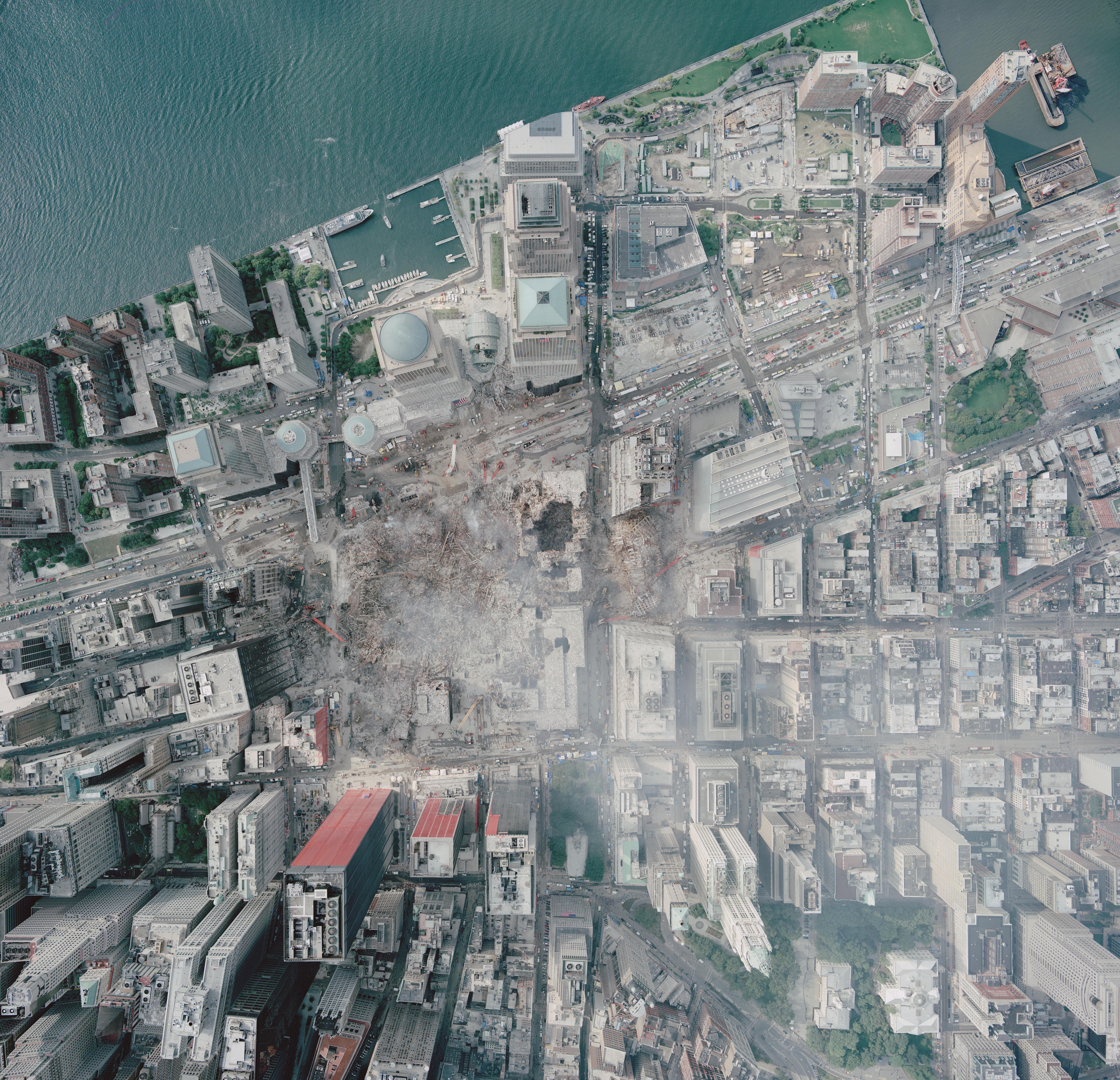
    Map of WTC after collapse

    Aerial_photo_of_WTC_groundzero.jpg


  • Registered Users Posts: 8,485 ✭✭✭Quantum Erasure


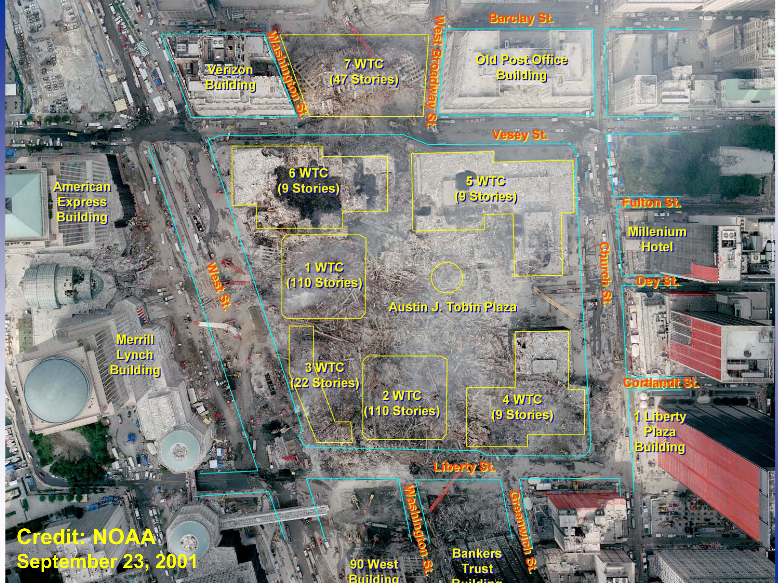
    same, rotated 90 degrees, with annotations, (i was looking to see where WTC 7 was located)

    World_Trade_Center_Site_After_9-11_Attacks_With_Original_Building_Locations.jpg


  • Registered Users Posts: 5,718 ✭✭✭Charles Babbage


    Placenames including droim on logainm.ie
    69.png


  • Closed Accounts Posts: 5,995 ✭✭✭Ipso


    Would that tight cluster be the drumlin belt?


  • Advertisement
  • Closed Accounts Posts: 5,995 ✭✭✭Ipso


    Place names beginning with Meena, I find it interesting how this is localized in Donegal (there are a load more that are not on that map).

    115.png


  • Registered Users Posts: 78,417 ✭✭✭✭Victor


    Ipso wrote: »
    Would that tight cluster be the drumlin belt?
    Yes, the word 'drumlin' comes from the word 'droim'.


  • Registered Users Posts: 33,629 ✭✭✭✭NIMAN


    same, rotated 90 degrees, with annotations, (i was looking to see where WTC 7 was located)

    World_Trade_Center_Site_After_9-11_Attacks_With_Original_Building_Locations.jpg

    So how many buildings actually fell that day?


  • Registered Users Posts: 78,417 ✭✭✭✭Victor


    NIMAN wrote: »
    So how many buildings actually fell that day?
    https://en.wikipedia.org/wiki/World_Trade_Center_(1973%E2%80%932001)#Destruction
    At 9:59 a.m., the South Tower collapsed after burning for approximately 56 minutes. The fire caused steel structural elements, already weakened from the plane's impact, to fail. The North Tower collapsed at 10:28 a.m., after burning for approximately 102 minutes.[154] At 5:20 p.m.[155] on September 11, 2001, 7 World Trade Center began to collapse with the crumbling of the east penthouse; it collapsed completely at 5:21 p.m.[155] owing to uncontrolled fires causing structural failure.[156]

    The Marriott World Trade Center hotel was destroyed during the collapse of the two towers. The three remaining buildings in the WTC plaza were extensively damaged by debris and were later demolished.[157] The cleanup and recovery process at the World Trade Center site took eight months.[158] The Deutsche Bank Building across Liberty Street from the World Trade Center complex was later condemned because of the uninhabitable toxic conditions inside; it was deconstructed, with work completed in early 2011.[159][160] The Borough of Manhattan Community College's Fiterman Hall at 30 West Broadway was also condemned owing to extensive damage, and it was demolished and completely rebuilt.[161]

    Four on the day - 1 WTC, 2 WTC, 7 WTC, Marriott. Note that many of the buildings were joined together at ground and basement level.


  • Registered Users Posts: 8,485 ✭✭✭Quantum Erasure


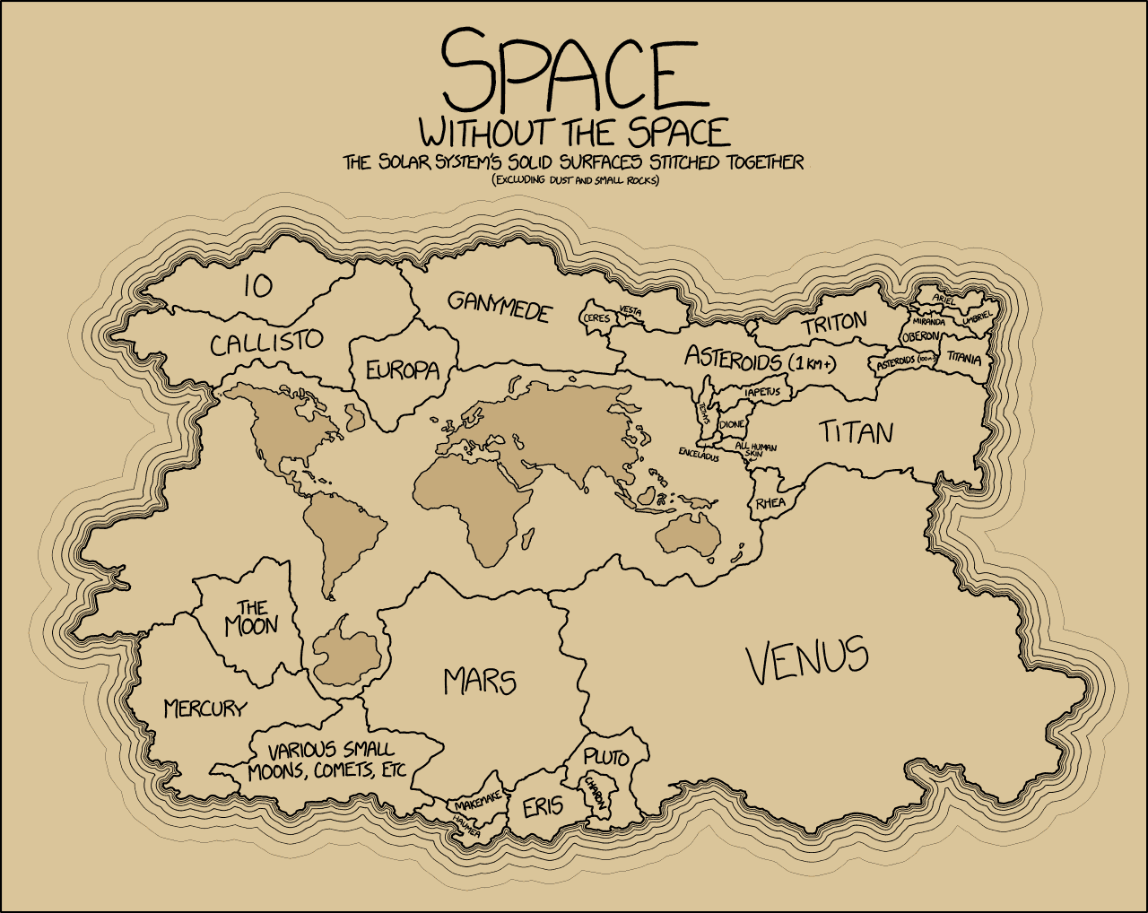
    not sure if this was posted before (click to enlarge)

    solar_system_map_of_surfaces.gif?content-type=image%2Fgif


  • Registered Users Posts: 10,430 ✭✭✭✭greenspurs


    NIMAN wrote: »
    So how many buildings actually fell that day?

    fell / Knocked.... etc etc ….

    But that's for another forum.... :P ;)

    "Bright lights and Thunder .................... " #NoPopcorn


  • Registered Users Posts: 3,272 ✭✭✭Barna77


    I don't know if this has been posted before.
    This is the bizarre patchy border between Belgium and the Netherlands at Baarle Hertog, an enclave in Dutch territory (Baarle Nassau for the Dutch). It gets crazier as there are Dutch lands within the Belgian ones :confused:

    I was there a couple o years ago and of course joke of the place is getting a pic stranding in between the two countries

    http://www.bbc.com/travel/story/20171210-europes-strange-border-anomaly

    [TnkC9PM.png?1


  • Moderators, Politics Moderators Posts: 39,763 Mod ✭✭✭✭Seth Brundle


    Barna77 wrote: »
    I don't know if this has been posted before.
    This is the bizarre patchy border between Belgium and the Netherlands at Baarle Hertog,
    <snip>
    Just the once, but worth posting again :D


  • Registered Users Posts: 25,420 ✭✭✭✭sligojoek


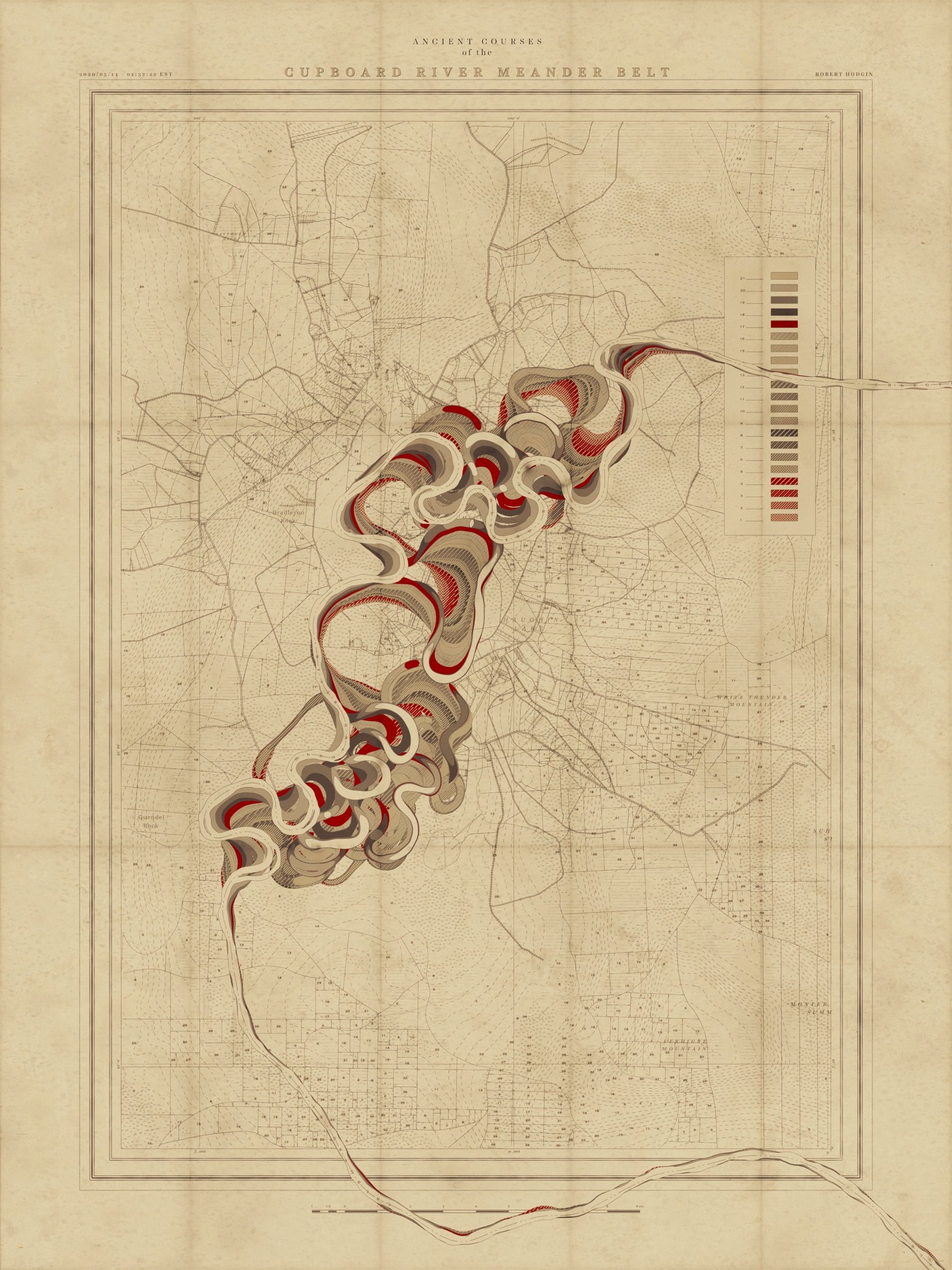
    Meander Maps for Imaginary Rivers

    From an input curve, the terrain, land plots, side roads, highways, marsh land and mountain peaks are generated and prominent features are named. The map is then weathered and rendered in the style of old US Army Corp of Engineers maps from the 1930s and 40s.

    More in the link


    https://kottke.org/20/05/meander-maps-for-imaginary-rivers


    robert-hodgin-meander-01.jpg


  • Advertisement
  • Registered Users Posts: 8,485 ✭✭✭Quantum Erasure


    Route of Phileas Fogg in Around the World in 80 Days


    zvblxbt3k5531.jpg


Advertisement