Advertisement
If you have a new account but are having problems posting or verifying your account, please email us on hello@boards.ie for help. Thanks :)
Hello all! Please ensure that you are posting a new thread or question in the appropriate forum. The Feedback forum is overwhelmed with questions that are having to be moved elsewhere. If you need help to verify your account contact hello@boards.ie

Interesting Maps

Options
15354565859250

Comments

  • Registered Users Posts: 18,963 ✭✭✭✭BonnieSituation


    (found on Reddit)
    In 1973, 40 nodes connected 45 computers. This was the entire internet at the time. This chart was found in 2016 amongst some old papers

    camfpeag2au51.jpg

    I have had that image on my desktop machine for well over a decade (that I've not turned on in a while) in anticipation that I would get it framed. It's class. Thanks for the reminder.


  • Registered Users Posts: 6,229 ✭✭✭highdef


    gerrybbadd wrote: »
    I love the true size of. It's great to take Vatican City and move it around various places. It's actually smaller than the relatively small estate i'm living in!

    The size of the Vatican looks to be very wrong. If I drag it over to the housing estate beside my home in Kildare, it looks tiny with the greatest distance from one side to the other being about 130m. However if I measure the distance of the widest side to side equivalent of Vatican in its normal location, it's over 1km across. The shape is completely different too. Going by the amount and size of the buildings visible, 1km looks about correct. 130m is most definitely NOT correct.


  • Moderators, Politics Moderators Posts: 39,559 Mod ✭✭✭✭Seth Brundle


  • Registered Users Posts: 22,292 ✭✭✭✭endacl


    Ulster Scots is a language? Hmmm. Let's see...

    Dae A need a new aerial?
    Gin ye hae guid analogue reception the nou, ye'r like no tae need tae replace yer ruiftap or set-tap aerial for the cheenge-ower – thare nae sic thing as a 'deegital aerial'. But gin ye hae ill analogue reception the nou, ye’ll mebbe need tae replace it.
    Find oot by gaun til the aerial-pruifer on Teletext page 284. Anither wey is tae wait until efter the cheenge-ower for tae see if yer pictur's affect.


    Doesn't compute.

    A language in the ‘bit of an accent’ sense only...


  • Banned (with Prison Access) Posts: 9,078 ✭✭✭IAMAMORON


    Their translation for the mentally handicapped is simply appalling, I wouldn't dare repeat it, you would probably end up getting a card.


  • Advertisement
  • Banned (with Prison Access) Posts: 9,078 ✭✭✭IAMAMORON


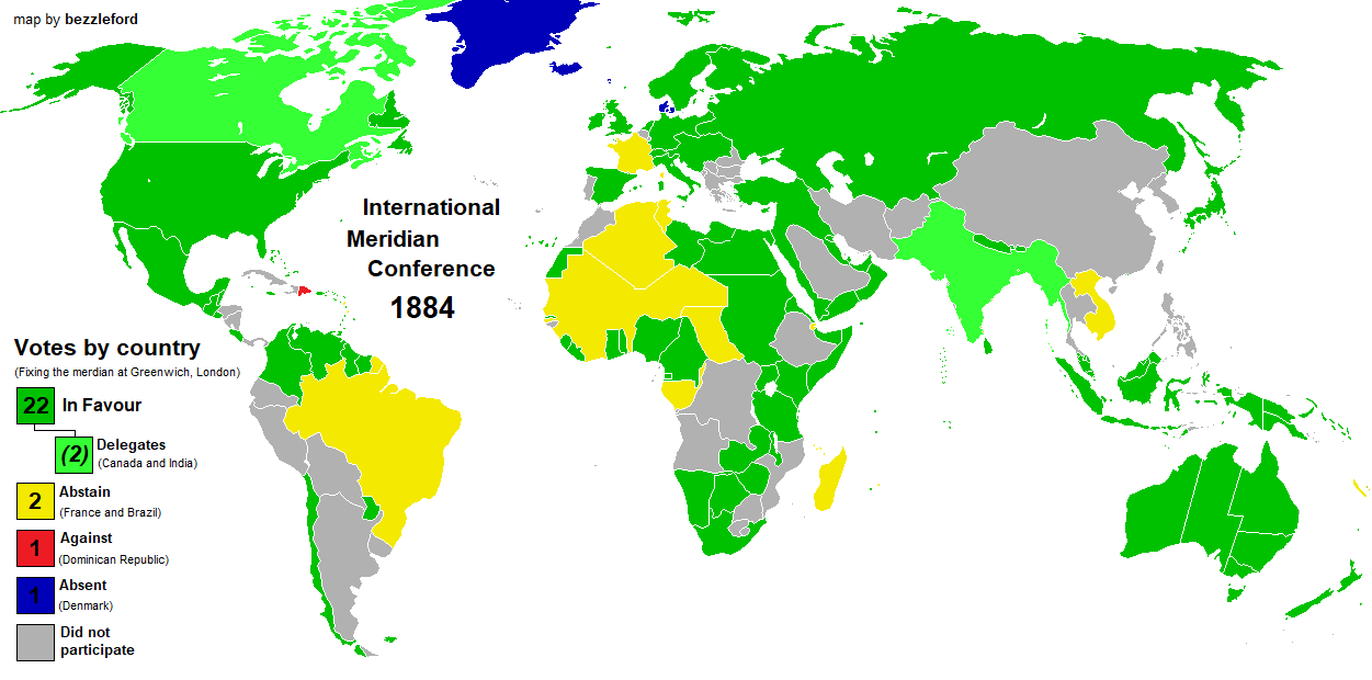
    Greenwich Meridian Vote 1884.

    Ek7AscQXIAEaqLs?format=png&name=large


  • Registered Users Posts: 8,426 ✭✭✭Quantum Erasure


    Don't know if I posted this earlier in the thread...


    1280px-France-Constituent-Lands.png


    Edit: even though New Caledonia is east of Australia, it is shown as north east of France, because that's the shortest route on a globe

    https://tinyurl.com/y3w85wvp (click 'load map' if it doesn't come up)

    For Wallis and Futuna, you pretty much go over the North pole... https://tinyurl.com/y3yn37ob


  • Moderators, Politics Moderators Posts: 39,559 Mod ✭✭✭✭Seth Brundle


  • Moderators, Politics Moderators Posts: 39,559 Mod ✭✭✭✭Seth Brundle


  • Moderators, Politics Moderators Posts: 39,559 Mod ✭✭✭✭Seth Brundle


    I'm loving this old map of Ireland...

    https://twitter.com/QUBSC/status/1304340170414710784


  • Advertisement
  • Closed Accounts Posts: 154 ✭✭Nexytus


    El-Hr-Cz-WUw-AAh4-TT.jpg


  • Registered Users Posts: 6,564 ✭✭✭Badly Drunk Boy


    Sunset times in Europe on the Summer Solstice:

    530765.png


  • Registered Users Posts: 4,468 ✭✭✭KevRossi


    This is the approximate size of the Vatican in relation to Dublin streets.


    530767.PNG


  • Registered Users Posts: 9,008 ✭✭✭Gregor Samsa


    Nexytus wrote: »
    Confederate States of America Map

    Is that map claiming that the Baja California Peninsula, Central America below Mexico, most of the Caribbean islands and what is now Guyana, Suriname and French Guiana were all part of of the Confederacy?


  • Registered Users Posts: 40,412 ✭✭✭✭ohnonotgmail


    Is that map claiming that the Baja California Peninsula, Central America below Mexico, most of the Caribbean islands and what is now Guyana, Suriname and French Guiana were all part of of the Confederacy?

    the map is nonsense. It has arizona and new mexico as states but they didnt become states until 1912


  • Registered Users Posts: 3,689 ✭✭✭chooseusername


    Don't know if I posted this earlier in the thread...

    That French Territories map reminds me of the pub quiz question about
    France's longest border.
    I thought I'd cracked it with Belgium.


  • Registered Users Posts: 16,164 ✭✭✭✭Pherekydes


    the map is nonsense. It has arizona and new mexico as states but they didnt become states until 1912

    They would have been territories. Still part of the confederacy though, as was much of Central America and the Caribbean.


  • Registered Users Posts: 40,412 ✭✭✭✭ohnonotgmail


    Pherekydes wrote: »
    They would have been territories. Still part of the confederacy though, as was much of Central America and the Caribbean.

    they were'nt part of the confederancy either. Not to mention chihuahua, sonora and baja not being part of Mexico. the map is a fantasy


  • Registered Users Posts: 9,008 ✭✭✭Gregor Samsa


    they were'nt part of the confederancy either. Not to mention chihuahua, sonora and baja not being part of Mexico. the map is a fantasy

    Ah, the map is a fantasy. It comes from one of those Reddit threads where they make up maps based on an alternative history. I guess it's supposed to be how the CS might have looked in 1904 had they won the Civil War and then done other stuff.

    Not only is the territory all wrong, but Confederate States didn't have a Department of Education, and that flag (3rd national flag/"Blood-Stained Banner") while official, was barely used as it was only introduced 3 months before the end of the war and the dissolution of the CS.


  • Registered Users Posts: 6,564 ✭✭✭Badly Drunk Boy


    That French Territories map reminds me of the pub quiz question about
    France's longest border.
    I thought I'd cracked it with Belgium.
    That was also on an earlier post in this thread.
    BRAZIL!!


  • Advertisement
  • Registered Users Posts: 40,412 ✭✭✭✭ohnonotgmail


    Ah, the map is a fantasy. It comes from one of those Reddit threads where they make up maps based on an alternative history. I guess it's supposed to be how the CS might have looked in 1904 had they won the Civil War and then done other stuff.

    Not only is the territory all wrong, but Confederate States didn't have a Department of Education, and that flag (3rd national flag/"Blood-Stained Banner") while official, was barely used as it was only introduced 3 months before the end of the war and the dissolution of the CS.
    well that makes more sense


  • Registered Users Posts: 9,008 ✭✭✭Gregor Samsa


    Poor Western Sahara gets a raw deal on this thread (and in general). On pretty much every map, it's down as "no data", due to the fact that Morocco's administration of it is unrecognised by everyone else - which I assume makes collecting data there rather difficult.

    530798.jpg

    However, one thing that Western Sahara has that no one else really does is berms - giant defensive sand walls built across the desert by the Moroccan military. The longest, known as the Moroccan Western Sahara Wall, is an about 2,700 km long and runs from Guerguerat in the south up to 200 km inside Morocco proper near the border with Algeria. It's 3m high (2m with a trench on one side) and riddled with observation towers, bunkers, fences and probably the longest continuous land mine field in the world. It separates the area controlled by Morocco on the west with the mostly uninhabited Sahrawi Arab Democratic Republic on the east (which is recognised by the African Union and has diplomatic relations with about 40 other countries).

    Anyway, here's a map of the berms of Western Sahara:

    530799.jpg


  • Moderators, Sports Moderators Posts: 7,199 Mod ✭✭✭✭cdeb


    Simon Reeve and Michael Palin have both featured them in their documentaries (Tropic of Cancer and Sahara respectively); worth a watch for those interested. One of those forgotten conflicts, but what Morocco is doing there is really no different to what China did to Tibet or the Brits did in the North. (And I'm sure lots of others have done in lots of other places, sadly)


  • Moderators, Politics Moderators Posts: 39,559 Mod ✭✭✭✭Seth Brundle


    From what I can tell, I think this is Newry...

    https://twitter.com/GeoConor/status/1321115239371444226


    ...and further on in that Twitter thread...
    https://twitter.com/wartimeni/status/1321133615284105217


  • Moderators, Politics Moderators Posts: 39,559 Mod ✭✭✭✭Seth Brundle


    National Parks in Ireland & the UK (excl. Scotland) - the National parks are the areas shaded in green - Ireland is comparatively disapointing...
    530830.jpg


  • Registered Users Posts: 40 AIRMiNet


    Irish Railway System in 1920 vs 2020

    mncks09s2mv51.png


  • Closed Accounts Posts: 326 ✭✭dzsfah2xoynme9


    AIRMiNet wrote: »
    Irish Railway System in 1920 vs 2020

    mncks09s2mv51.png

    You can take the Navan-Kingscourt line, the South Wexford line, the New Ross line and the Limerick-Foynes line out of that. All disused and mostly in tatters.


  • Registered Users Posts: 78,369 ✭✭✭✭Victor


    National Parks in Ireland & the UK (excl. Scotland) - the National parks are the areas shaded in green - Ireland is comparatively disapointing...
    https://www.boards.ie/vbulletin/attachment.php?attachmentid=530830&stc=1&d=1603823796

    National Parks in the UK and Ireland have very different definitions. In Ireland, the are fully state owned and primarily forestry and bog. In the UK, they are primarily privately owned and are often grassland in farms.


  • Moderators, Social & Fun Moderators Posts: 12,731 Mod ✭✭✭✭JupiterKid


    Political map of the world if global sea levels rise by 1,000 metres.


    11417_n7vhp4uh7ihl1iyr.jpeg


  • Advertisement
  • Registered Users Posts: 20,047 ✭✭✭✭cnocbui


    No wonder the Chinese invaded Tibet and are trying to steal India's high bits. Sneaky devils.

    Australia, the land down under.


Advertisement