Advertisement
If you have a new account but are having problems posting or verifying your account, please email us on hello@boards.ie for help. Thanks :)
Hello all! Please ensure that you are posting a new thread or question in the appropriate forum. The Feedback forum is overwhelmed with questions that are having to be moved elsewhere. If you need help to verify your account contact hello@boards.ie

Interesting Maps

Options
194959799100250

Comments

  • Moderators, Category Moderators, Social & Fun Moderators, Society & Culture Moderators Posts: 23,149 CMod ✭✭✭✭Ten of Swords


    Back on topic please, riveting as your 3 page sniping match is :rolleyes:


  • Registered Users Posts: 9,007 ✭✭✭Gregor Samsa


    Dublin 1833
    dublin-map.jpg

    Great map. You can see the city bound by the North Circular and South Circular roads (both just called "Circular Road" on this). Same as the M50 was to effectively bound the city when it was first envisaged. I wonder when and where the next ring road will be built around the city?

    My grandfather on my mother's side was born and raised just off Pearse Street (Shaw Villas) in the 1900s. In the late 20s and early 30s, he worked on the construction of Mario Church, and then when the (then) council houses in Marino were built, he and my grandmother got one. His mother was distraught that he was moving "out the country" and thought she'd never see him again.

    My dad was born in Donnycarney. By the time he was young, the city had expanded out, and Collins Avenue was the limit. His father used to mainly drink in The Refuge pub on the Malahide road (inside the city area), but on Sundays he'd go up to The Goblet in Artane, because it was in Co. Dublin then, and subject to different licencing laws.


  • Registered Users Posts: 13,839 ✭✭✭✭josip


    Dublin 1833
    dublin-map.jpg


    I see it included the Kingstown Railroad, the construction contract for which was signed in May 1833.


  • Registered Users Posts: 9,395 ✭✭✭Shedite27


    While we're on the topic of Dublin addresses, that's the official line as to the boundaries between suburbs? Is there any map or one source of truth that An Post or something use?

    I live at an intersection of Drumcondra, Whitehall, Marino and Beaumont, never really knew what to refer to it as. Address says Drumcondra but have a feeling it falls into the same scenario of neighbours wanting to be fancy


  • Registered Users Posts: 9,007 ✭✭✭Gregor Samsa


    Shedite27 wrote: »
    I live at an intersection of Drumcondra, Whitehall, Marino and Beaumont, never really knew what to refer to it as. Address says Drumcondra but have a feeling it falls into the same scenario of neighbours wanting to be fancy

    Here's the official boundaries of the Townland of Drumcondra (not to be confused with the much larger Electoral Division of Drumcondra).

    552324.png

    here's the map. You can find any townland, electoral division or Civil Parish you want. Often they vary from the Catholic Church Parish of the same name, so things can get confusing.

    https://www.townlands.ie/dublin/coolock/clonturk/drumcondra/drumcondra/


    You can even see on that map that Drumcondra is labeled much further south than the actual boundaries of the Townland. The area names in common usage are really nebulous.

    For instance, the official Townland of Donnycarney doesn't include half of what the locals regard as Donnycarney. It even stops half way up Donnycarney Road (the road was extended at some point after Belton Park was built in the 1930s.), and much of the area locals call Donnycarney is officially in the townland of Artane South, which is a name no-one uses at all.

    https://www.townlands.ie/dublin/coolock/clonturk/clontarf-west/donnycarney/


  • Advertisement
  • Registered Users Posts: 2,090 ✭✭✭Hodors Appletart


    Shedite27 wrote: »
    have a feeling it falls into the same scenario of neighbours wanting to be fancy

    This is correct really, especially where new housing is concerned.


  • Registered Users Posts: 14,219 ✭✭✭✭retalivity


    Great map. You can see the city bound by the North Circular and South Circular roads (both just called "Circular Road" on this). Same as the M50 was to effectively bound the city when it was first envisaged. I wonder when and where the next ring road will be built around the city?

    Planning was underway, then shelved til at least 2035 - https://en.wikipedia.org/wiki/Outer_Orbital_Route
    This map below is apparently from boards from 2009!

    http://www.indymedia.ie/attachments/nov2009/dublinroadmap.png


  • Registered Users Posts: 9,395 ✭✭✭Shedite27


    Here's the official boundaries of the Townland of Drumcondra (not to be confused with the much larger Electoral Division of Drumcondra).

    552324.png

    here's the map. You can find any townland, electoral division or Civil Parish you want. Often they vary from the Catholic Church Parish of the same name, so things can get confusing.

    https://www.townlands.ie/dublin/coolock/clonturk/drumcondra/drumcondra/

    You can even see on that map that Drumcondra is labeled much further south than the actual boundaries of the Townland. The area names in common usage are really nebulous.

    For instance, the official Townland of Donnycarney doesn't include half of what the locals regard as Donnycarney. It even stops half way up Donnycarney Road (the road was extended at some point after Belton Park was built in the 1930s.), and much of the area locals call Donnycarney is officially in the townland of Artane South, which is a name no-one uses at all.

    https://www.townlands.ie/dublin/coolock/clonturk/clontarf-west/donnycarney/
    Thanks, turns out I live in Goosegreen. Never seen that on a sign or address. I guess that's where the local pub gets its name
    https://www.facebook.com/TheGooseTavern/


  • Registered Users Posts: 14,219 ✭✭✭✭retalivity


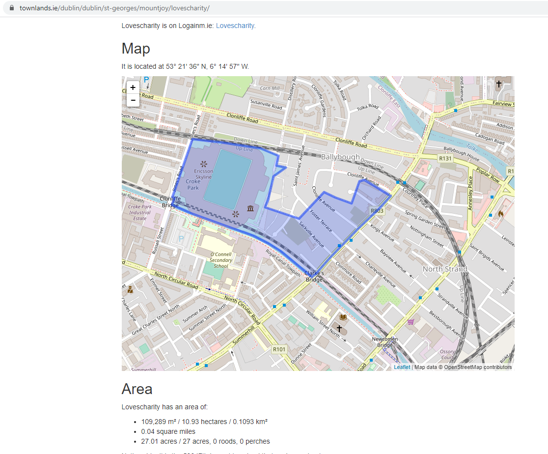
    Ah here, Croke Park and GAA HQ is in a townland called "Lovescharity"? Really??

    6e341de5953e59c67351417746b7758f.png


  • Registered Users Posts: 2,320 ✭✭✭Chet T16


    Here's the official boundaries of the Townland of Drumcondra (not to be confused with the much larger Electoral Division of Drumcondra).

    https://www.boards.ie/vbulletin/attachment.php?attachmentid=552324&stc=1&d=1620216049

    here's the map. You can find any townland, electoral division or Civil Parish you want. Often they vary from the Catholic Church Parish of the same name, so things can get confusing.

    https://www.townlands.ie/dublin/coolock/clonturk/drumcondra/drumcondra/


    You can even see on that map that Drumcondra is labeled much further south than the actual boundaries of the Townland. The area names in common usage are really nebulous.

    For instance, the official Townland of Donnycarney doesn't include half of what the locals regard as Donnycarney. It even stops half way up Donnycarney Road (the road was extended at some point after Belton Park was built in the 1930s.), and much of the area locals call Donnycarney is officially in the townland of Artane South, which is a name no-one uses at all.

    https://www.townlands.ie/dublin/coolock/clonturk/clontarf-west/donnycarney/

    That map source is very interesting (imagine!). The place I stayed briefly which had Marino in the address at least twice isn't actually Marino. I mocked the petrol station up the road for labeling itself as Clontarf but it turns out that was more correct!


  • Advertisement
  • Registered Users Posts: 9,007 ✭✭✭Gregor Samsa


    Shedite27 wrote: »
    Thanks, turns out I live in Goosegreen. Never seen that on a sign or address. I guess that's where the local pub gets its name
    https://www.facebook.com/TheGooseTavern/

    Ah, the Goozer! I know it well. Yeah, no-one calls the area Goosegreen, but that's the official name.


  • Moderators, Category Moderators, Arts Moderators, Sports Moderators Posts: 49,342 CMod ✭✭✭✭magicbastarder


    there's also a gooseacre beside the botanic gardens.


  • Registered Users Posts: 2,707 ✭✭✭PommieBast


    while using wikipedia as a source is problematic they didn't even do that right. There are 2 dots in New Zealand when there were at least 8 separate wars between the british and the maori over a period of more than 25 years.
    Noticed that huge burst that corresponded with the English civil war and did wonder about the bias in the sources..


  • Registered Users Posts: 9,007 ✭✭✭Gregor Samsa


    I've been looking for any kind of enclaves (using the term loosely) within Ireland, and the nearest I've come is these three:

    First up, Drummully, Co. Monaghan (aka Coleman's Island). Only accessible by road via Northern Ireland (Co. Fermanagh), and so the only one with an international border.

    552340.png

    Secondly, the "tied island" of Aughinish, in north Co. Clare, which is only accessible by road via Co. Galway.

    552342.jpg

    And thirdly, Co. Letrim, which you cannot travel (by road) from north to south of without going into either Co. Cavan or Co. Roscommon (Lough Allen and the river Shannon are in the way).

    552344.jpg

    Does anyone have any others?


  • Registered Users Posts: 409 ✭✭Mullinabreena


    Does anyone have any others?


    This bit of Co Sligo that cuts into Roscomon


  • Registered Users Posts: 409 ✭✭Mullinabreena


    Anyone notice that Google maps in China doesn't line up with the satellite imagery?

    Screenshot-20210505-152423-Maps.jpg


  • Registered Users Posts: 8,721 ✭✭✭blackwhite


    Anyone notice that Google maps in China doesn't line up with the satellite imagery?

    Screenshot-20210505-152423-Maps.jpg[IMG][/img]


    https://en.wikipedia.org/wiki/Restrictions_on_geographic_data_in_China


  • Registered Users Posts: 3,682 ✭✭✭chooseusername


    I've been looking for any kind of enclaves (using the term loosely) within Ireland, and the nearest I've come is these three:

    First up, Drummully, Co. Monaghan (aka Coleman's Island). Only accessible by road via Northern Ireland (Co. Fermanagh), and so the only one with an international border.


    Does anyone have any others?

    https://www.google.com/maps/@52.1276531,-8.0760538,13.78z
    Waterford / Cork border,
    Looks like a loop the loop but on a closer look it's open at the narrow point.


  • Moderators, Category Moderators, Arts Moderators, Sports Moderators Posts: 49,342 CMod ✭✭✭✭magicbastarder


    i assume this border here reflects a now straightened meandering river system?

    https://www.google.com/maps/@53.591971,-6.2827753,242m/data=!3m1!1e3


  • Registered Users Posts: 18,925 ✭✭✭✭BonnieSituation


    https://www.google.com/maps/@52.1276531,-8.0760538,13.78z
    Waterford / Cork border,
    Looks like a loop the loop but on a closer look it's open at the narrow point.

    Always loved that spot. Fascinates me.

    We also have the madness of Ferrybank, Co Waterford...

    https://www.google.com/maps/@52.2671236,-7.107433,15z

    The bridge stopping it being a true enclave of Kilkenny.


  • Advertisement
  • Registered Users Posts: 3,682 ✭✭✭chooseusername


    i assume this border here reflects a now straightened meandering river system?

    https://www.google.com/maps/@53.591971,-6.2827753,242m/data=!3m1!1e3

    The river has straightened out a bit,
    https://www.boards.ie/vbulletin/attachment.php?attachmentid=552363&stc=1&d=1620244273


  • Registered Users Posts: 6,305 ✭✭✭alias no.9


    bubblypop wrote: »
    The only even number north of the liffey is D8, the phoenix park is in Dublin 8.

    Dublin 20 crosses the Liffey too


  • Registered Users Posts: 18,925 ✭✭✭✭BonnieSituation


    alias no.9 wrote: »
    Dublin 20 crosses the Liffey too

    Don't mention the war


  • Registered Users Posts: 9,007 ✭✭✭Gregor Samsa


    i assume this border here reflects a now straightened meandering river system?

    https://www.google.com/maps/@53.591971,-6.2827753,242m/data=!3m1!1e3

    I’m fascinated by borders that are or were based on the course of a river. They make perfect sense, because rivers seem like ageless, immutable natural frontiers that can be relied on to define the edge of your territory in perpetuity. But actually they’re dynamic, evolving features that have their own agenda.


  • Moderators, Category Moderators, Arts Moderators, Sports Moderators Posts: 49,342 CMod ✭✭✭✭magicbastarder


    cheers - not that there's anything at stake, but i wonder whether the new path of the river would still functionally be regarded as the border?

    i.e. if i put in a planning application for something which *was* on the dublin side of the river but is now on the meath side, would common sense or the old map prevail?


  • Registered Users Posts: 3,682 ✭✭✭chooseusername


    I’m fascinated by borders that are or were based on the course of a river. They make perfect sense, because rivers seem like ageless, immutable natural frontiers that can be relied on to define the edge of your territory in perpetuity. But actually they’re dynamic, evolving features that have their own agenda.

    One of the few things I remember from geography,
    how the meanders straighten out over time.


  • Registered Users Posts: 6,305 ✭✭✭alias no.9


    Don't mention the war

    Appologies, I replied as I was reading, I've since seen the carnage.


  • Registered Users Posts: 1,314 ✭✭✭Speedsie
    ¡arriba, arriba! ¡andale, andale!


    I've been looking for any kind of enclaves (using the term loosely) within Ireland, and the nearest I've come is these three:

    Does anyone have any others?

    It's more of an ecclesiastical exclave, and I've no idea how I'd find a map of it, but the parish church of Seirkieran is officially part of the diocese of Cashel, Ferns & Ossory (part of Mountrath Union), but it is fully contained within the diocesan boundaries of Limerick, Killaloe & Ardfert.


  • Registered Users Posts: 3,272 ✭✭✭Barna77


    I’m fascinated by borders that are or were based on the course of a river. They make perfect sense, because rivers seem like ageless, immutable natural frontiers that can be relied on to define the edge of your territory in perpetuity. But actually they’re dynamic, evolving features that have their own agenda.

    Clearly seen in some US state borders on the Mississippi river.
    The river has bent and cut off over and over again, creating some state pocket islands over time.


  • Advertisement
  • Registered Users Posts: 18,925 ✭✭✭✭BonnieSituation


    cheers - not that there's anything at stake, but i wonder whether the new path of the river would still functionally be regarded as the border?

    i.e. if i put in a planning application for something which *was* on the dublin side of the river but is now on the meath side, would common sense or the old map prevail?

    Nope. The old map prevails. That being said, the old map has to exist and that's a whole other kettle of fish. We use a non-conclusive boundary system in Ireland and site/deed/land registry maps are merely indicative of what "should exist" or "what did exist" when the map was made.

    You can read about that here... https://www.prai.ie/mapping-practice/

    This compares with the European "Cadaster" system that uses well-defined mapping to register properties.

    There are many reasons for a river changing course and not all of them are natural.

    One job I was involved in a few years back was involved in a boundary query for this site at Glasnevin cemetery:

    552366.JPG


    Some time in the mid- to late-90s a storm caused flooding to the north of the cemetery. Remedial works were carried out but as part of the flood defence, the Tolka was re-routed slightly.

    This caused great difficulty given the land now bordering the cemetery as part of its "flood-plain" was part of the folio/site directly to the north. It was a mess. A fascinating mess.


Advertisement