Advertisement
If you have a new account but are having problems posting or verifying your account, please email us on hello@boards.ie for help. Thanks :)
Hello all! Please ensure that you are posting a new thread or question in the appropriate forum. The Feedback forum is overwhelmed with questions that are having to be moved elsewhere. If you need help to verify your account contact hello@boards.ie

2021 Atlantic/Pacific Hurricane Season

2456

Comments

  • Moderators, Science, Health & Environment Moderators Posts: 12,053 Mod ✭✭✭✭Meteorite58


    Weakened considerably, seeing some storm damage mostly from fallen trees heavy in leafy , some power outages, flooding seems to be the main concern now.


  • Registered Users, Registered Users 2 Posts: 5,965 ✭✭✭Storm 10


    Will it head across the Atlantic like some storms or some other direction


  • Moderators, Science, Health & Environment Moderators Posts: 12,053 Mod ✭✭✭✭Meteorite58


    Looks like most of the remnants head up towards Greenland / Iceland, at the moment nothing of note gets absorbed into other areas of LP, but with these features you never know, models often go haywire when they come into our latitudes, Hp blocking looks fairly consistent in the main models on current runs.


  • Registered Users, Registered Users 2 Posts: 8,219 ✭✭✭Gaoth Laidir


    Selected preliminary Storm Total Rainfall in inches from 800 PM
    EDT Sat Aug 21 through 1000 AM EDT Mon Aug 23...
    
    ...CONNECTICUT...
    ENE MANCHESTER                       5.00                    
    SOUTH WINDSOR                        4.50                    
    HEBRON 2 SW                          4.41                    
    NEW LONDON                           3.70                    
    NORWICH                              3.25                    
    GROTON                               2.99                    
    PAWCATUCK                            2.39                    
    
    ...DELAWARE...
    LEWES 7.8 S                          3.42                    
    LONG NECK 6.5 NW                     3.38                    
    DOVER 5.1 WSW                        2.97                    
    FELTON 3.6 NE                        2.91                    
    
    ...MASSACHUSETTS...
    FEEDING HILLS                        2.77                    
    SOUTHWICK                            2.72                    
    SOUTHAMPTON                          2.52                    
    BECKET                               2.25                    
    PITTSFIELD                           1.94                    
    SANDISFIELD 3 S                      1.72                    
    EAST OTIS                            1.67                    
    
    ...NEW JERSEY...
    CRANBURY                             8.91                    
    JAMESBURG                            8.66                    
    FRANKLIN TWP 0.4 W                   8.51                    
    BEDMINSTER TWP 2.9 ESE               7.73                    
    PLAINSBORO TWP 1.8 ESE               7.71                    
    FREDON TWP 2.4 NE                    7.67                    
    HOPEWELL 0.4 SSW                     6.69                    
    HARRISON                             6.68                    
    LEBANON 0.5 E                        6.55                    
    LYNDHURST                            6.50                    
    LONG BEACH TWP 1.4 SSE               6.49                    
    HELMETTA 0.1 NE                      6.17                    
    JERSEY CITY                          5.95                    
    SURF CITY                            5.81                    
    SHIP BOTTOM                          5.65                    
    STRAFFORD TWP 2.2 NNE                5.25                    
    MCGUIRE AFB                          2.15                    
    
    ...NEW YORK...
    BROOKLYN                             8.03                    
    PROSPECT PARK                        7.77                    
    SOUTH SLOPE                          7.05                    
    CENTRAL PARK                         7.04                    
    LAKE SUCCESS 1 WSW                   6.58                    
    MIDTOWN MANHATTAN                    6.46                    
    BOERUM HILL                          6.16                    
    BATTERY PARK                         6.15                    
    
    ...PENNSYLVANIA...
    BLAKESLEE 0.9 SW                     6.67                    
    SCHNECKSVILLE 1.7 ENE                6.50                    
    SAYLORSBURG                          6.24                    
    PORTLAND 2.7 WNW                     5.82                    
    NORTH WALES SW                       5.81                    
    ARDMORE                              4.25                    
    NEW HANOVER                          2.06                    
    EAGLEVILLE                           1.93                    
    BRISTOL                              1.86                    
    
    ...RHODE ISLAND...
    WESTERLY 1 S                         3.81                    
    RICHMOND 1 E                         3.24                    
    CHARLESTOWN 1 E                      3.07                    
    WESTERLY ARPT                        2.73                    
    SOUTH KINGSTOWN                      2.48                    
    COVENTRY                             2.00                    
    WESTERLY STATE AIRPORT               1.76                    
    WAKEFIELD-PEACEDALE 5.0 SW           1.32                    
    NEWPORT, NEWPORT STATE AIRPORT       1.21                    
    SOUTH KINGSTON 4.3 WSW               1.00                    
    CHARLESTOWN 0.7 E                    0.98                    
    WAKEFIELD 0.8 ENE                    0.97                    
    PROVIDENCE                           0.38 THEODORE GREEN AIRPT
    
    ...Selected preliminary Peak Wind gusts in miles per hour earlier
    in the event...
    
    ...CONNECTICUT...
    STONGINGTON OUTER BREAKWATER           55                    
    GROTON ARPT                            53                    
    USCG ACADEMY                           49                    
    STONINGTON OUTER BREAKWATER            48                    
    HARTFORD BRADLEY INTL ARPT             44                    
    
    ...MASSACHUSETTS...
    WOODS HOLE                             55                    
    MASHPEE                                51                    
    WEST ISLAND                            51                    
    WELLFLEET                              48                    
    BORDEN FLATS LIGHT                     47                    
    DUXBURY                                47                    
    VINEYARD STATION                       46                    
    WEST DENNIS                            45                    
    
    ...NEW YORK...
    GREAT GULL ISLAND                      69                    
    STONY BROOK                            53                    
    BAITING HOLLOW                         52                    
    ORIENT 1 N                             50                    
    SHINNECOCK                             49                    
    NAPEAGUE                               48                    
    
    ...RHODE ISLAND...
    POINT JUDITH                           70                    
    UNIVERSITY OF RHODE ISLAND             69                    
    HALFWAY ROCK                           68                    
    BLOCK ISLAND JETTY                     63                    
    NEW SHOREHAM                           63 


  • Moderators, Science, Health & Environment Moderators Posts: 12,053 Mod ✭✭✭✭Meteorite58


  • Advertisement
  • Registered Users, Registered Users 2 Posts: 8,219 ✭✭✭Gaoth Laidir


    Recon data have shown it's now a tropical storm, so it has been named Ida tonight. Current winds 35 knots.

    Its current projected path should take it close to or over the Loop Current Eddy south of New Orleans. Ocean Heat Content in this area is up to 150 kJ/cm². That could cause rapid intensification just before landfall later Sunday, but still a lot of uncertainty on the exact track as of now. One to watch.


  • Registered Users Posts: 105 ✭✭zisdead


    And if Ida held on the current track and did rapidly intensify it's about as bad as it could get for New orleans as it would take the full brunt of the stronger right side of the then hurricane.


  • Registered Users, Registered Users 2 Posts: 8,219 ✭✭✭Gaoth Laidir


    Part of the latest NHC Discussion. They have it 95 knots near the LA coast but I wouldn't be surprised to see higher than that.

    FORECAST POSITIONS AND MAX WINDS
    
    INIT  27/0300Z 18.6N  80.5W   35 KT  40 MPH
     12H  27/1200Z 19.9N  82.0W   45 KT  50 MPH
     24H  28/0000Z 21.8N  83.9W   55 KT  65 MPH...NEAR CUBA
     36H  28/1200Z 23.8N  85.9W   65 KT  75 MPH
     48H  29/0000Z 25.6N  88.0W   75 KT  85 MPH
     60H  29/1200Z 27.3N  89.6W   85 KT 100 MPH
     72H  30/0000Z 29.0N  90.6W   95 KT 110 MPH...NEAR THE COAST
     96H  31/0000Z 32.0N  91.0W   45 KT  50 MPH...INLAND
    120H  01/0000Z 33.9N  88.8W   25 KT  30 MPH...INLAND
    
    There is some southwesterly vertical wind shear affecting Ida at the
    moment, which is the likely part of the reason the cloud pattern and
    wind field are asymmetric.  However, the global model show the
    upper-level pattern becoming quite favorable late Friday and through
    the weekend.  These more conducive winds aloft combined with very
    warm SSTs and abundant moisture is likely to result in steady or
    rapid intensification until Ida makes landfall in the U.S. The
    intensity guidance unanimously show Ida becoming a hurricane, but
    there is notable spread in how strong the system will become.  Given
    the expected favorable environmental conditions for the storm, the
    NHC intensity forecast lies near the high end of the model guidance,
    in best agreement with the regional hurricane models.  It is also
    worth noting that even though the global models are not particularly
    accurate in predicting tropical cyclone winds, the GFS and ECMWF
    show the minimum pressure falling more than 35 mb from the current
    conditions.  Based on all of this information, there is
    higher-than-normal confidence that a significant hurricane will be
    approaching the Gulf coast late this weekend.


  • Registered Users, Registered Users 2 Posts: 8,219 ✭✭✭Gaoth Laidir


    Current track takes it right over the core of the warm Loop Current Eddy.


  • Registered Users, Registered Users 2 Posts: 7,215 ✭✭✭pad199207


    Near Cayman

    Looking at its track over those warm ocean anomalies GL, Irma feelings with this one


  • Advertisement
  • Registered Users, Registered Users 2 Posts: 8,219 ✭✭✭Gaoth Laidir


    It's currently over a cool Caribbean anomaly, but the next 24-36 hours will be interesting to watch.


  • Moderators, Science, Health & Environment Moderators Posts: 12,053 Mod ✭✭✭✭Meteorite58


    Hurricane Hunters Recon mission have pushed up sustained wind speeds to 60 mph. Could be a hurricane shortly. Models showing Ida could be a Major Hurricane just before or at landfall , very high storm surge and rainfall of 8 to 16+ inches predicted.

    NHC

    There continues to be some southwesterly shear affecting Ida due to

    the storm's location between an upper-level trough to the west and

    an upper-level anticyclone to the east. Some decrease in the shear

    is expected during the next 24 h, and that, combined with a moist

    environment and warm sea surface temperatures along the forecast

    track, should allow steady to rapid strengthening until the cyclone

    makes landfall along the northern Gulf coast. The new intensity

    forecast is slightly stronger than the previous forecast, and it now

    calls for Ida to reach a peak intensity of 100 kt before landfall.

    It should be noted that this intensity is lower than that forecast

    by the HMON model, the HCCA corrected consensus model, and the

    Florida State Superensemble. After landfall, Ida should weaken as

    it moves through the lower Mississippi and Tennessee River valleys.

    Based on the available guidance, there remains higher-than-normal

    confidence that a significant hurricane will approach and impact the

    Gulf coast during the weekend and early next week.


  • Registered Users, Registered Users 2 Posts: 7,215 ✭✭✭pad199207


    Organisation and intensification continues today. When it clears Cuba it’s going to be fascinating to watch.

    Cat 4 not out of the question for Louisiana. Would be a real push for a Cat 5 if it were to occur.


  • Registered Users, Registered Users 2 Posts: 8,219 ✭✭✭Gaoth Laidir


    It's now been upgraded to a hurricane based on latest recon data. Cat 4 definitely is on the cards.

    FORECAST POSITIONS AND MAX WINDS
    
    INIT  27/1500Z 20.7N  82.1W   55 KT  65 MPH
     12H  28/0000Z 22.2N  83.7W   65 KT  75 MPH...OVER WESTERN CUBA
     24H  28/1200Z 24.0N  85.8W   75 KT  85 MPH...OVER WATER
     36H  29/0000Z 25.9N  87.8W   90 KT 105 MPH
     48H  29/1200Z 27.6N  89.7W  105 KT 120 MPH
     60H  30/0000Z 29.0N  90.8W  105 KT 120 MPH
     72H  30/1200Z 30.3N  91.3W   60 KT  70 MPH...INLAND
     96H  31/1200Z 33.3N  90.2W   30 KT  35 MPH...INLAND
    120H  01/1200Z 35.2N  87.1W   20 KT  25 MPH...POST-TROP/REMNT LOW


  • Registered Users, Registered Users 2 Posts: 8,219 ✭✭✭Gaoth Laidir


    Shite...


  • Registered Users Posts: 23,866 ✭✭✭✭Kermit.de.frog


    Now 80 mph, Cat 1. Anticipated 140 mph Cat 4 now at landfall according to latest NHC advisory

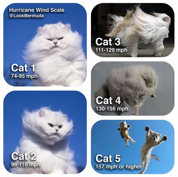
    Know your hurricanes


  • Registered Users, Registered Users 2 Posts: 8,219 ✭✭✭Gaoth Laidir


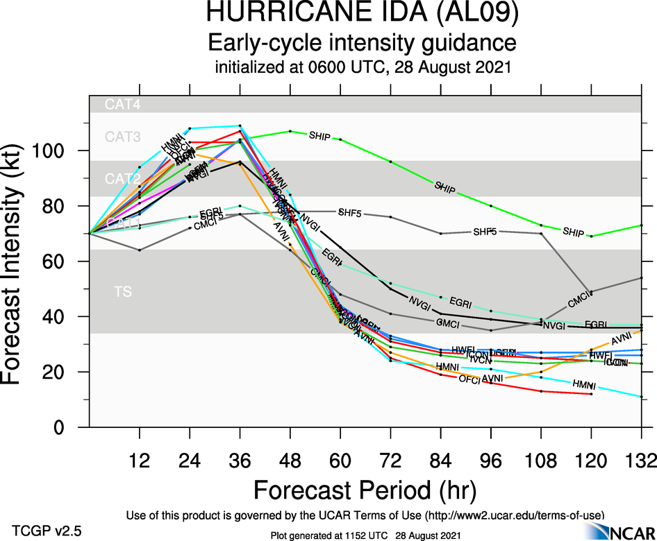
    18Z SHIPS LGEM has it at 127 knots 62 km from land in 48 hours. This will be a big one...

                                     *                  GFS version                   *
                                     * ATLANTIC     2021 SHIPS INTENSITY FORECAST     *
                                     * IR SAT DATA AVAILABLE,       OHC AVAILABLE     *
                                     *  IDA         AL092021  08/27/21  18 UTC        *
    
    TIME (HR)          0     6    12    18    24    36    48    60    72    84    96   108   120   132   144   156   168
    V (KT) NO LAND    70    80    89    98   106   112   121   115   111    97    84    74    66    61    58    57    55
    V (KT) LAND       70    67    83    92   100   107   116    77    44    32    28    27    27    27    27    27    27
    V (KT) LGEM       70    70    85    94   102   120   127    87    47    33    29    27    27    27    27    27    27
    Storm Type      TROP  TROP  TROP  TROP  TROP  TROP  TROP  TROP  TROP  TROP  TROP  TROP  TROP  TROP  TROP  TROP  TROP
    
    SHEAR (KT)        11    13    11     8     7    17     9    16    11    19    12    25    20    24    12    18    16
    SHEAR ADJ (KT)    -1     1     0    -3    -5     1    -5     5     1     1     3     0     3    -3     0     2     0
    SHEAR DIR        216   202   233   249   245   288   263   268   267   267   263   262   257   280   277   319   348
    SST (C)         29.5  29.7  29.9  29.8  30.0  30.2  30.7  31.3  32.0  31.6  30.9  30.8  29.9  29.6  29.5  28.9  29.3
    POT. INT. (KT)   162   165   169   167   171   172   171   170   170   171   171   170   167   162   160   150   156
    ADJ. POT. INT.   154   156   159   155   157   157   159   167   170   171   156   151   136   133   132   123   127
    200 MB T (C)   -52.8 -52.5 -52.7 -52.7 -52.1 -51.9 -51.8 -51.8 -51.7 -51.5 -51.8 -51.5 -51.0 -51.1 -52.1 -53.5 -54.1
    200 MB VXT (C)   0.8   1.3   1.7   1.5   0.9   0.7   1.1   1.6   1.1   1.3   0.2   0.6   0.6   1.0   1.4   0.7   0.1
    TH_E DEV (C)       9     8     8     8     8     7     7     5     7     4     7     2     5     1     3     0     1
    700-500 MB RH     64    66    66    65    67    69    73    69    74    67    70    55    47    37    33    39    45
    MODEL VTX (KT)    17    18    18    19    21    23    29    27    27    24    20    18    14    12     9     8     7
    850 MB ENV VOR    47    37    26    14    14    -9    -8   -39    -7   -43    34    14    63    31    45    17    16
    200 MB DIV        86    48    49    57    26     7    41    41    79    56    51    24    10   -39   -32   -54   -35
    700-850 TADV       8     7     0     2     4    13     6    10    16    15     9     0    -3    -5     0   -10    -8
    LAND (KM)         98   -18   126   268   410   217    62   -43  -159  -277  -422  -506  -563  -461  -334  -200   -32
    LAT (DEG N)     21.6  22.5  23.4  24.4  25.3  27.1  28.6  29.9  31.3  32.8  34.3  35.3  35.6 xx.x  xx.x  xx.x  xx.x 
    LONG(DEG W)     82.7  83.8  84.9  85.8  86.8  88.9  90.5  91.2  91.5  90.9  89.6  88.0  86.3 xxx.x xxx.x xxx.x xxx.x
    STM SPEED (KT)    14    14    13    13    13    12     8     7     8     8     9     8     8     9    10     9     7
    HEAT CONTENT      71    92   122    97   105   133    42    16     7     7     6     6     5     4     4     3     4


  • Registered Users, Registered Users 2 Posts: 8,219 ✭✭✭Gaoth Laidir


    Downgrade in model intensity this morning, though I reckon the 12Z will show an uptick again.


  • Registered Users, Registered Users 2 Posts: 8,219 ✭✭✭Gaoth Laidir


  • Registered Users, Registered Users 2 Posts: 40,300 ✭✭✭✭Itssoeasy


    It making landfall 16 years to the day since Katrina must be giving Louisiana officials flashbacks. There seems to be a genuine worry from meteorologists I follow on Twitter who are part of the big TV networks. The mayor of New Orleans said last night they don’t have time to implement a counter flow system on the highway system which isn’t great.


  • Advertisement
  • Registered Users, Registered Users 2 Posts: 8,219 ✭✭✭Gaoth Laidir


    Still 70 knots in the latest update but forecast to peak at 120 kts.

    Hurricane Ida Discussion Number   8
    NWS National Hurricane Center Miami FL       AL092021
    400 AM CDT Sat Aug 28 2021
    
    Just after the last advisory, the convective structure of Ida got a
    bit ragged, probably due to the residual effects of land
    interaction with Cuba and a tongue of dry air that wrapped into the
    eastern side of the circulation.  However, latest radar images from
    Cuba show that the eye is becoming better defined, and satellite
    imagery shows cooling of the cloud tops in the eyewall.  The
    initial intensity has been held at 70 kt based on the latest trends
    and earlier Hurricane Hunter aircraft data.  NOAA and Air Force
    reserve Hurricane Hunter aircraft are scheduled to investigate Ida
    again starting around 12Z.
    
    The initial motion remains northwestward or 315/14.  A subtropical 
    ridge centered off the southeast U.S. coast is expected to shift 
    westward through the weekend, and this feature should continue to 
    provide a steering flow that will take Ida steadily northwestward 
    across the Gulf of Mexico during the next 36-48 h.  The track 
    guidance remains in good agreement that Ida will make landfall on 
    the coast of southeastern or central Louisiana late Sunday or early 
    Monday morning.  After landfall, Ida is expected to turn northward 
    through Louisiana and western Mississippi at a slower forward speed 
    as it moves around the western end of the ridge.  Recurvature into 
    the westerlies and an east-northeastward motion are expected by the 
    end of the forecast period.  The new forecast track is nudged 
    slightly to the west after 36 h to keep it near the various 
    consensus models, but this is not a significant change from the 
    previous forecast.  Users are again reminded to not focus on the 
    exact details of the track forecast as storm surge, wind, and 
    rainfall impacts will extend far from the center.
    
    Ida is expected to remain in a favorable environment of light
    vertical shear and very warm sea-surface temperatures until it
    makes landfall.  The only negative factor is the possibility that
    dry air may try to entrain into the system and slow the expected
    intensification.  The SHIPS and LGEM models are showing a little
    less strengthening than previously.  However, the HWRF and HMON
    models continue to forecast Ida to reach Category 4 intensity
    before landfall.  The new intensity forecast will forecast a peak
    intensity of 120 kt in best agreement with the HWRF and HMON, and
    the pre-landfall part of the forecast is little changed from the
    previous forecast.  After landfall, rapid weakening is expected due
    to land interaction, drier air, and an increase in shear, and Ida
    is expected to become a post-tropical cyclone as it moves through
    the Tennessee Valley.
    
    As Ida continues to intensify over the Gulf of Mexico, an expansion
    of its wind field is predicted. The NHC wind radii forecast is
    largely based on the radii consensus, and winds of at least tropical
    storm force are likely to reach the coast Sunday morning. Therefore,
    all preparations to protect life and property for this dangerous
    event need to be made today.
    
    
    Key Messages:
    
    1. Hurricane and tropical storm conditions are ending over Cuba.
    However, Ida will continue to bring periods of heavy rain across
    western Cuba through today that may lead to flash flooding and
    mudslides.
    
    2. There is a danger of life-threatening storm surge inundation
    Sunday along the coasts of Louisiana and Mississippi within the
    Storm Surge Warning area. Extremely life-threatening inundation of
    10 to 15 feet above ground level is possible within the area from
    Morgan City, Louisiana, to the Mouth of the Mississippi River.
    Interests throughout the warning area should follow any advice given
    by local officials.
    
    3. Ida is expected to be an extremely dangerous major hurricane when
    it reaches the coast of Louisiana. Hurricane-force winds are
    expected Sunday in portions of the Hurricane Warning area along the
    Louisiana coast, including metropolitan New Orleans, with
    potentially catastrophic wind damage possible where the core of Ida
    moves onshore. Actions to protect life and property should be rushed
    to completion in the warning area.
    
    4. Ida is likely to produce heavy rainfall later Sunday into Monday
    across the central Gulf Coast from southeast Louisiana to coastal
    Mississippi resulting in significant flash and riverine flooding
    impacts. As Ida moves inland, flooding impacts are possible across
    portions of the Lower Mississippi and Tennessee Valleys.
    
    
    FORECAST POSITIONS AND MAX WINDS
    
    INIT  28/0900Z 24.0N  85.2W   70 KT  80 MPH
     12H  28/1800Z 25.4N  86.9W   85 KT 100 MPH
     24H  29/0600Z 27.1N  88.9W  105 KT 120 MPH
     36H  29/1800Z 28.6N  90.5W  120 KT 140 MPH
     48H  30/0600Z 30.1N  91.3W   85 KT 100 MPH...INLAND
     60H  30/1800Z 31.6N  91.2W   45 KT  50 MPH...INLAND
     72H  31/0600Z 33.2N  90.5W   30 KT  35 MPH...INLAND
     96H  01/0600Z 36.0N  87.0W   25 KT  30 MPH...INLAND
    120H  02/0600Z 37.5N  82.5W   20 KT  25 MPH...POST-TROP/REMNT LOW


  • Registered Users, Registered Users 2 Posts: 7,215 ✭✭✭pad199207


    She’s off now


  • Moderators, Science, Health & Environment Moderators Posts: 12,053 Mod ✭✭✭✭Meteorite58


    Looks like there will be a well defined eyewall shortly. Incredible nerve and expertise displayed by the NHC. A bit less strengthening form SHIPS then earlier as stated by NHC but there seems to be high confidence of rapid intensification from the main hurricane models to become a Major Cat 4 Hurricane with peak winds of 120 kts forecast just before or at landfall. Only slight adjustments to track.


    NHC

    Users are again reminded to not focus on the 
    exact details of the track forecast as storm surge, wind, and 
    rainfall impacts will extend far from the center.


  • Registered Users, Registered Users 2 Posts: 8,219 ✭✭✭Gaoth Laidir


    The 06Z SHIPS has a 12-hour step from 36-48 hours during which additional strengthening before landfall can occur. At 36 hours it's 104 kts and 72 km from land, moving at 15 kph, so about 4 hours before landfall. In any case, it looks like landfalling in a relatively unpopulated area of the swamps, unless an easterly shift takes it closer to New Orleans.


  • Registered Users, Registered Users 2 Posts: 7,215 ✭✭✭pad199207


    We have an eye now


  • Registered Users Posts: 23,866 ✭✭✭✭Kermit.de.frog


    There is little or no shear on the track. Upper level high pressure in place, perfect conditions. It doesn't get much more ideal. Be surprised if this didn't take off like a rocket strength wise in the next few hours.


  • Registered Users, Registered Users 2 Posts: 6,238 ✭✭✭Oneiric 3


    NAM Path.

    New Moon


  • Registered Users, Registered Users 2 Posts: 8,219 ✭✭✭Gaoth Laidir


    It's 85 knots now in the latest update.


  • Moderators, Science, Health & Environment Moderators Posts: 12,053 Mod ✭✭✭✭Meteorite58


  • Advertisement
  • Moderators, Science, Health & Environment Moderators Posts: 12,053 Mod ✭✭✭✭Meteorite58


    Reports now from the US that Ida has become a Cat 2 with 100 mph max sustained winds with higher gusts, Min pressure 976 mb

    National Weather Service

    Additional rapid strengthening is forecast during the next 24hr and #Ida is expected to be an extremely dangerous major hurricane when it approaches the northern Gulf coast Sunday.


Advertisement