Advertisement
If you have a new account but are having problems posting or verifying your account, please email us on hello@boards.ie for help. Thanks :)
Hello all! Please ensure that you are posting a new thread or question in the appropriate forum. The Feedback forum is overwhelmed with questions that are having to be moved elsewhere. If you need help to verify your account contact hello@boards.ie

Where is West Clare ?!?!

Options
  • 20-06-2024 11:45pm
    #1
    Registered Users Posts: 7


    Hi

    Doing some tourism promotional work , and wondering where exactly/ officially does West Clare begin? Is their any official map showing this? Is it from Lissycasey back, or does it extend more towards Ennis ?


Comments

  • Registered Users Posts: 31 baxterooneydoody


    Lahinch to cross and back as far as kilrush up towards coore and the hand direction


  • Registered Users Posts: 7 longyjohny


    Surly it goes more east than kilrush town and the hand?? More towards Lissycasey. Is it shown on any maps ?


  • Registered Users Posts: 31 baxterooneydoody


    Not that I know of but over the years if working with people from that area anything west of kilrush was "back the west" and south of Lahinch was west clare also, unless there's an electoral map or something similar showing a definite point I would think its more an interpretation than a geographical area


  • Registered Users Posts: 160 ✭✭Calculator123


    I would have said anything west of a vertical line through Ennis was "West Clare" which would include pretty much all of the Burren as well as the ocean coastline and outer Estuary. West Clare is mostly a concept though and perhaps nostalgically includes all the tourist hotspots and more rugged landscapes irrespective of boundary.

    This map from the Visit Clare website would suggest even more complication!


  • Registered Users Posts: 349 ✭✭iniscealtra


    The map is good regarding how areas are referred to n Clare.


  • Advertisement
  • Registered Users Posts: 4,562 ✭✭✭jackboy


    A line drawn between ennis and lahince would be more accurate. I would have always considered Lahince to be right on the border of where North clare starts.


  • Registered Users Posts: 9,007 ✭✭✭Gregor Samsa


    That tourist map seems to be based on the official 2018 Electoral Divisions in Co. Clare, except the official area names are Kilrush LEA, Ennistymon LEA, Ennis LEA, Killaloe LEA and Shannon LEA, rather than West Clare, North Clare, Ennis, East Clare, and South Clare. The same divisions were used in the 2024 local elections.

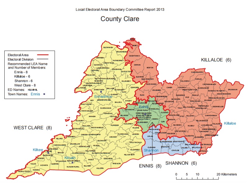
    Back in 2013, things were very different. There was a "West Clare", but it stretched right up to Galway Bay. Ennis and Killaloe were different shapes, and there was no North Clare/Ennystimon district.

    The point is, the terms West Clare, etc. aren't (always) official and depend on context. The exact boundaries would depend on who you talk to.

    I'd personally include Lahinch as the most southerly coastal point of North Clare, and Miltown Malbay as West Clare. But others might disagree.


Advertisement