Advertisement
If you have a new account but are having problems posting or verifying your account, please email us on hello@boards.ie for help. Thanks :)
Hello all! Please ensure that you are posting a new thread or question in the appropriate forum. The Feedback forum is overwhelmed with questions that are having to be moved elsewhere. If you need help to verify your account contact hello@boards.ie
Hi there,
There is an issue with role permissions that is being worked on at the moment.
If you are having trouble with access or permissions on regional forums please post here to get access: https://www.boards.ie/discussion/2058365403/you-do-not-have-permission-for-that#latest

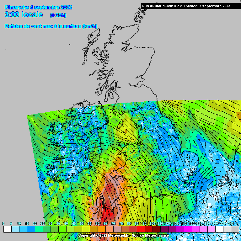
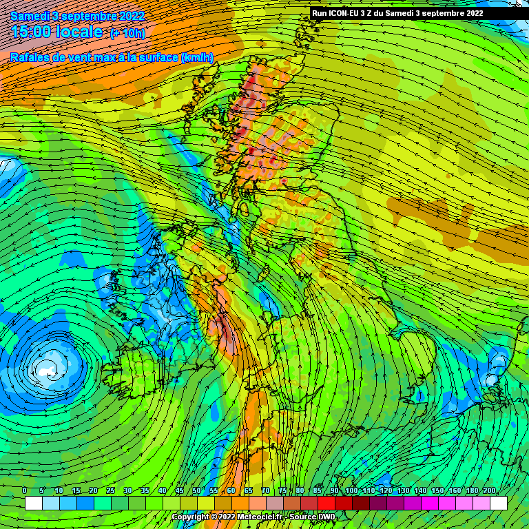
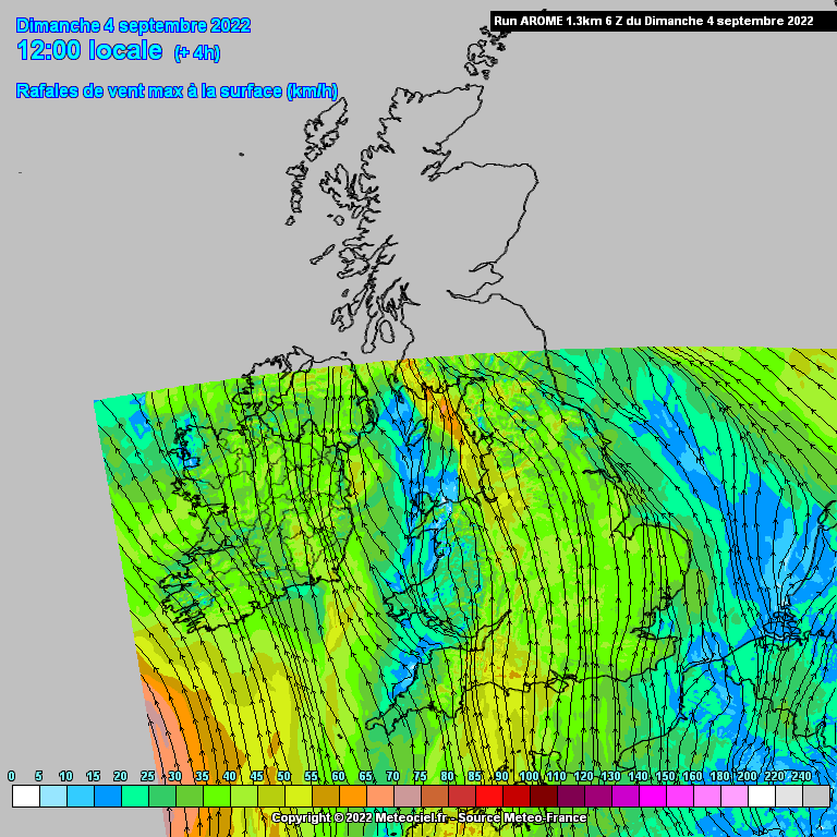
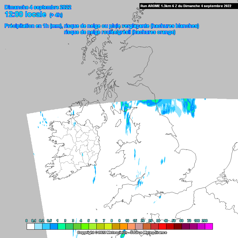
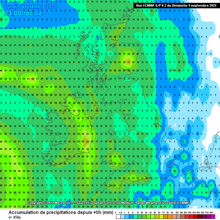
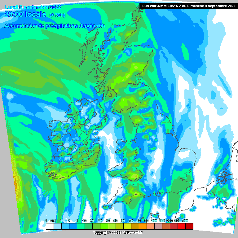
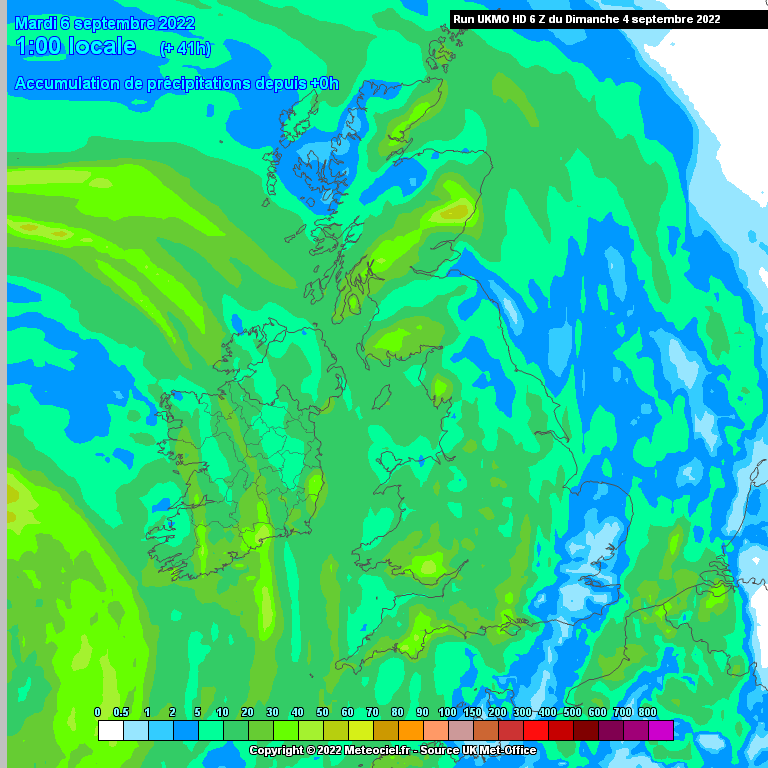
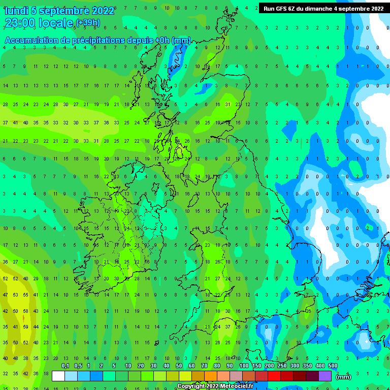
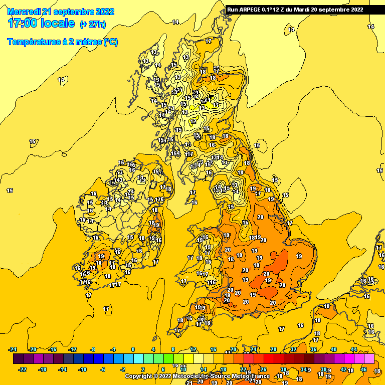
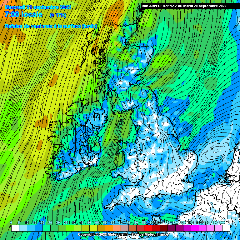
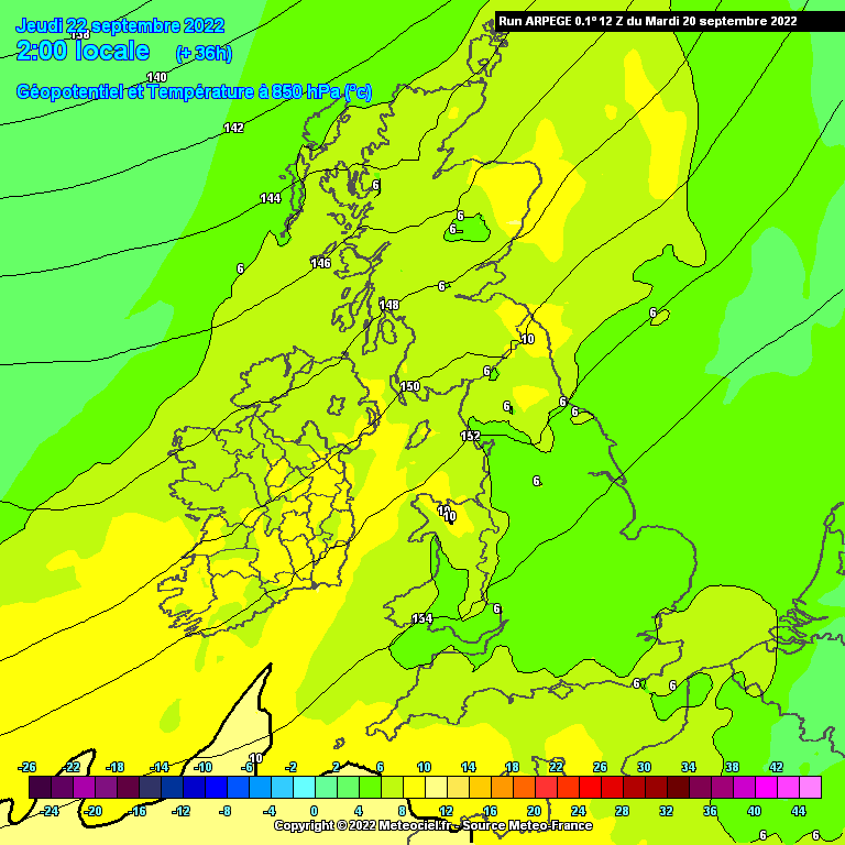
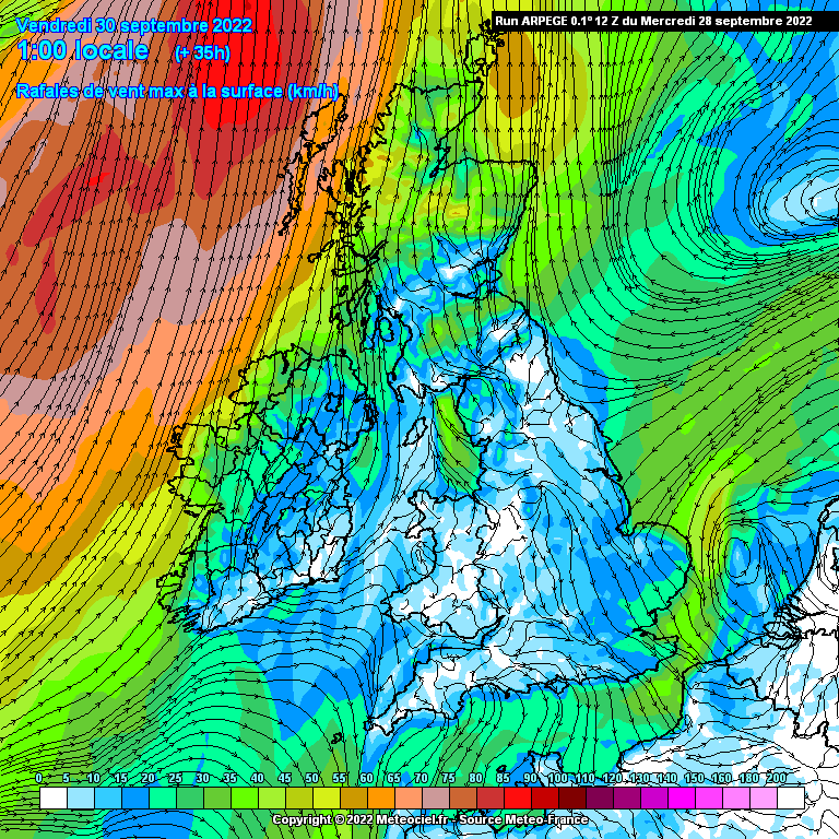
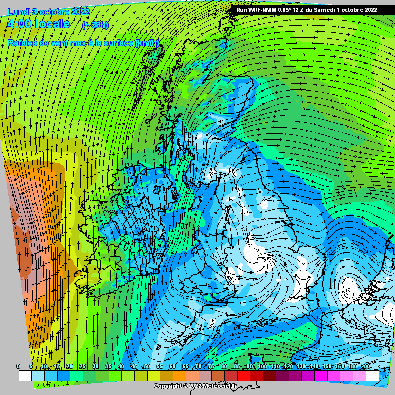
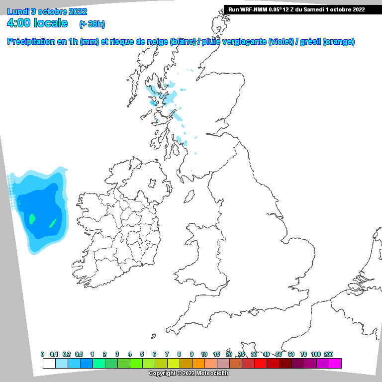
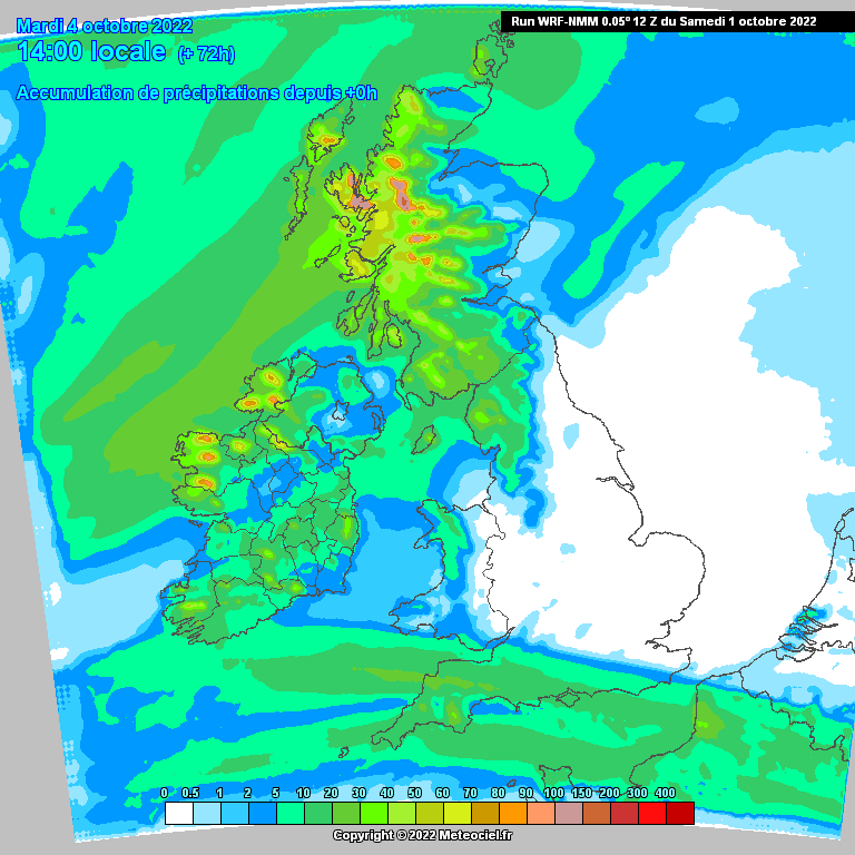
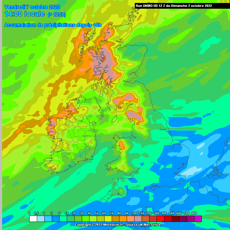
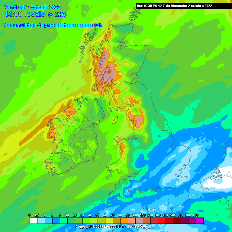
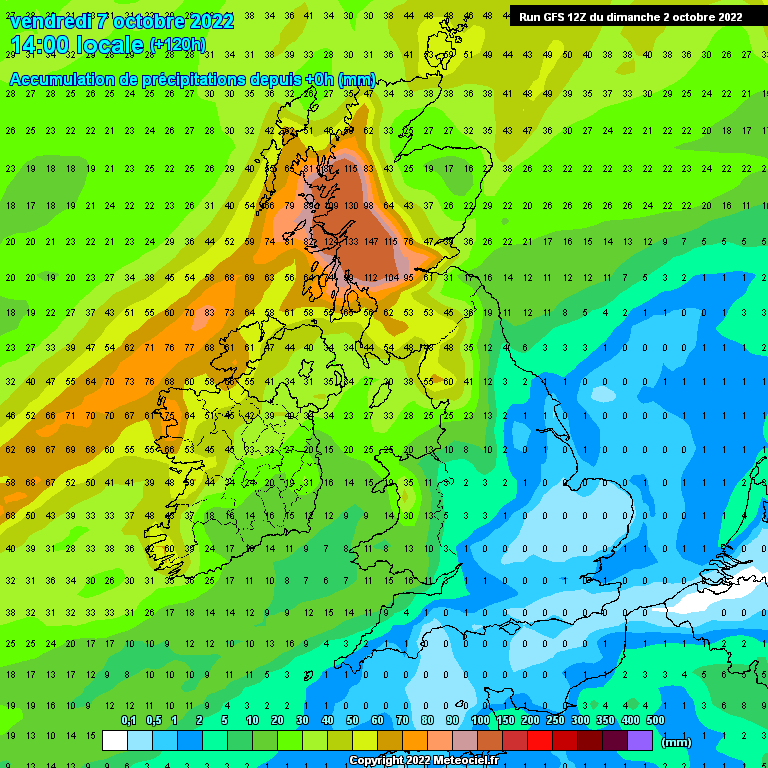
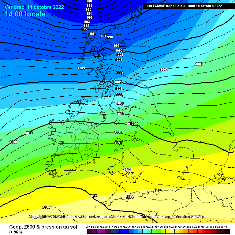
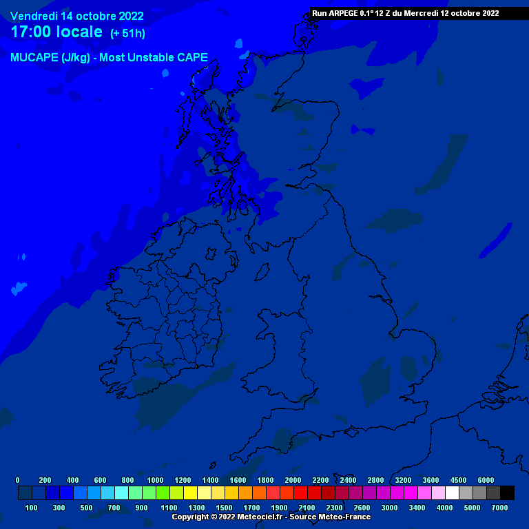
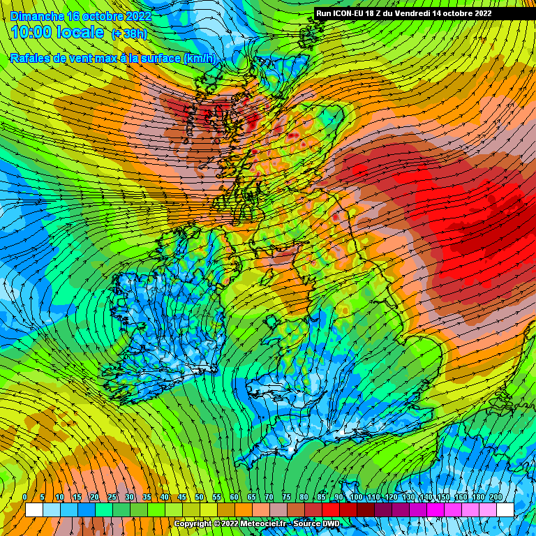
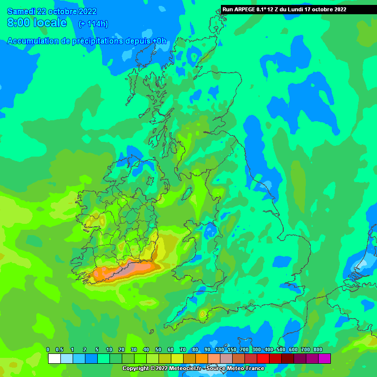
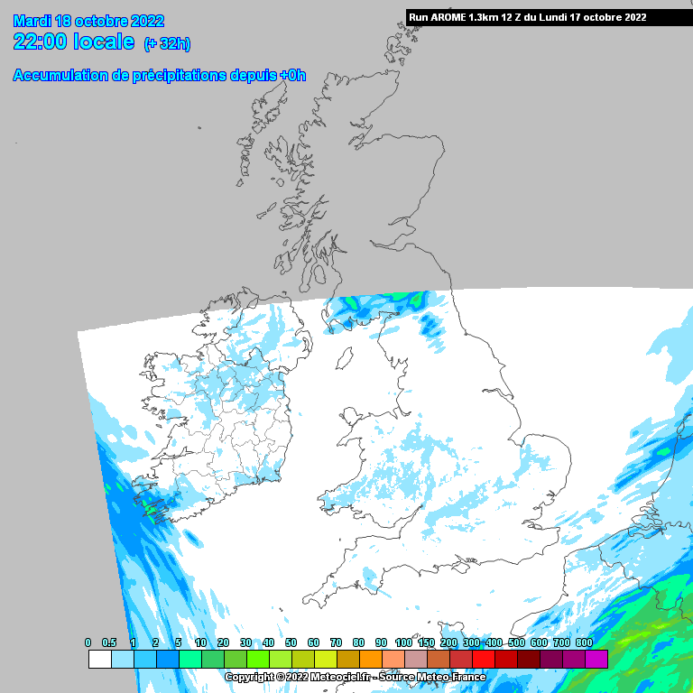
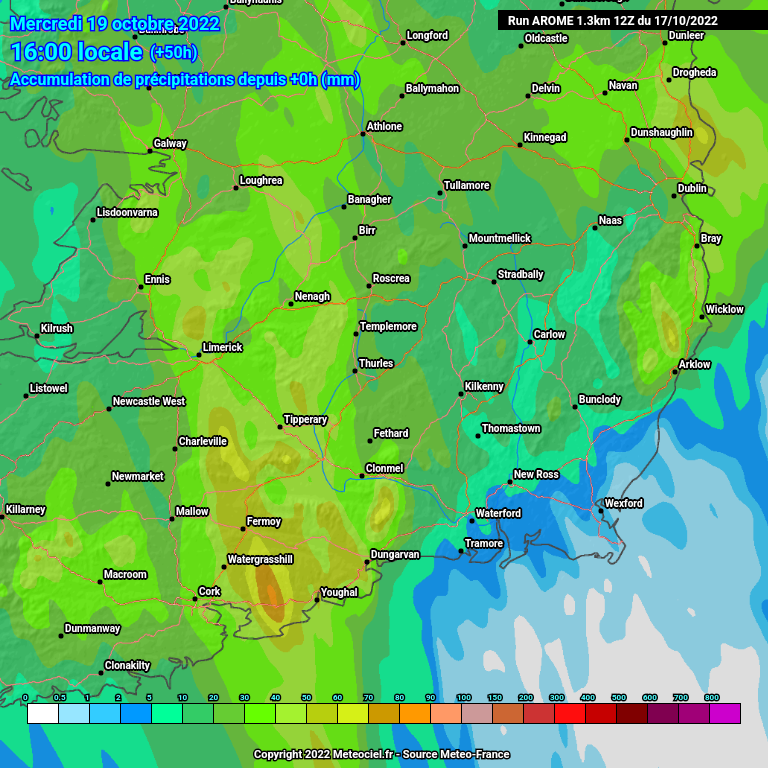
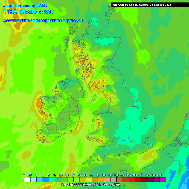
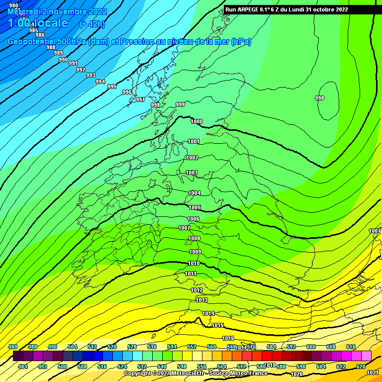
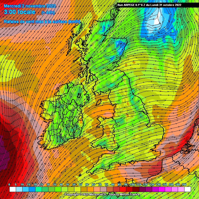
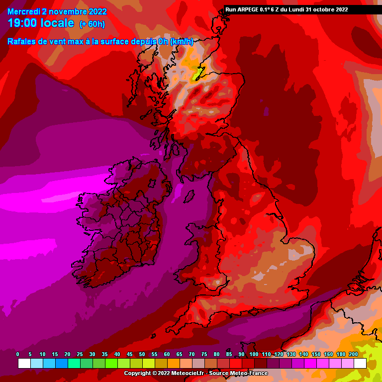
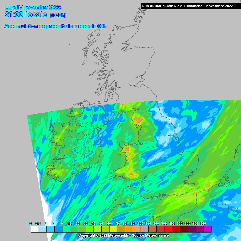
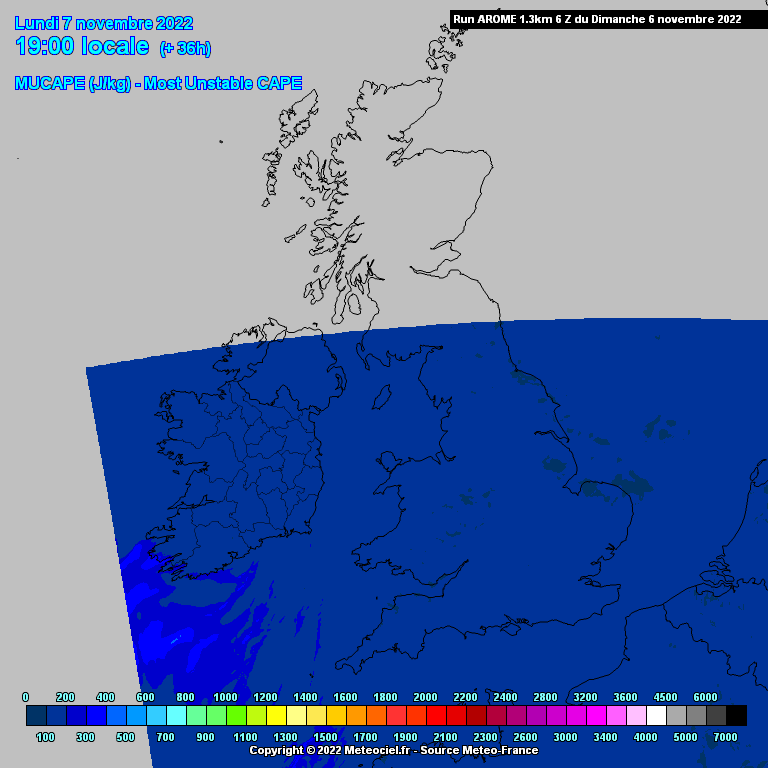
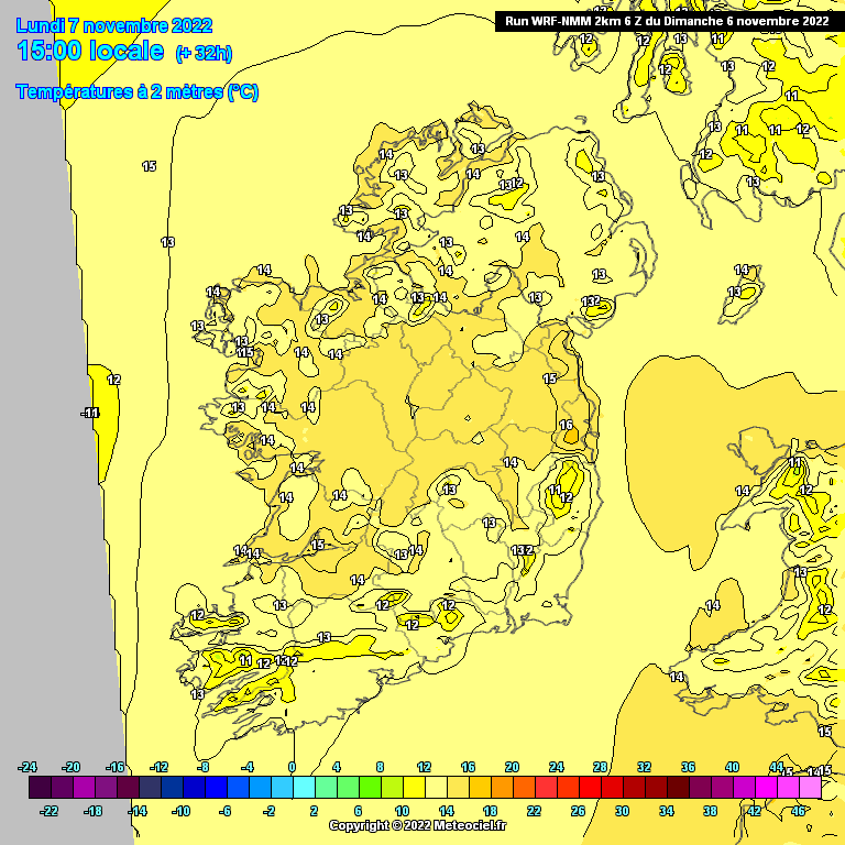
Charts ( Up to T120 ) Autumn 2022 ** READ MOD NOTE IN FIRST POST**

  • 31-08-2022 8:38pm
    #1
    Moderators, Science, Health & Environment Moderators Posts: 12,136 Mod ✭✭✭✭


    Over the weekend into next week will certainly draw a line between Summer and Autumn, temperatures dropping back with some cool nights, plentiful rain, windy at times and thunderstorms a possibility with possible hail . The charts are still evolving, would definitely call it a complex area of LP with some short waves developing into smaller deeper areas of LP that could bring strong winds with sharper gradients and more pronounced fronts giving thunderstorm potential. The Jet is a factor being close or over Ireland at times .Upper low a lot colder then we have seen for a number of months and given that the seas are at their warmest a lot of instability in the atmosphere is possible giving some very heavy local rain potential. Could see some warnings over the weekend into next week.


«1

Comments

  • Registered Users Posts: 563 ✭✭✭Cumhachtach


    Just checking into the thread. May everyone have a happy, healthy autumn and get a fair bit of your preferred weather type.


  • Registered Users, Registered Users 2 Posts: 7,217 ✭✭✭pauldry


    Yes Autumn begins Friday more especially into Friday evening so by this time next week a lot of places will have seen strong winds and rainfall totalling 100mm. The drought will be gone.


  • Moderators, Science, Health & Environment Moderators Posts: 12,136 Mod ✭✭✭✭Meteorite58


    ECM has been showing some sort of a windy event early Sun morning for the last few runs but the last run has really upgraded it into a potent little system deepening as it crosses the country, for now through Munster mainly. For the last few runs it has been showing something but the other models havent developed anything of note for that timeframe although they do seem to show potential just off the East , in general the models are showing windy weather later Sun night into Monday in varying amounts but still uncertainty how strong. Great deal of uncertainty yet but it would seem Met Eireann are noting the ECM .

    Met Eireann

    SATURDAY NIGHT: While there is still some uncertainty about the extent of how windy it may get on Saturday night and Sunday, generally It looks like wet and blustery conditions will extend from the south across the country on Saturday night with some heavy falls of rain at times. Lowest temperatures of 8 to 13 degrees generally as fresh and gusty southeasterly winds veer southwesterly later. Although it should be noted that winds may be stronger locally.


  • Moderators, Science, Health & Environment Moderators Posts: 12,136 Mod ✭✭✭✭Meteorite58


    ECM more in line now with the other models keeping the strong winds more to the East of the country from early Sun, not too strong at this stage but models still have a bit to go to putting a finishing look on this.


  • Registered Users, Registered Users 2 Posts: 7,227 ✭✭✭pad199207


    Status Yellow - Rain warning for Ireland

    Met Éireann Weather Warning

    High rainfall amounts this weekend may cause disruption.

    Valid: 21:00 Saturday 03/09/2022 to 12:00 Sunday 04/09/2022

    Issued: 08:39 Friday 02/09/2022


  • Advertisement
  • Moderators, Science, Health & Environment Moderators Posts: 12,136 Mod ✭✭✭✭Meteorite58


    A general emphasis on the Eastern half of the country for the heaviest rainfall totals over the next 24hrs but could get some locally heavy rain anywhere if caught under a convective burst. The NE shows up as getting some high totals. Heaviest of the rain in the early hours of Sun morning possibly accompanied with embedded thunderstorms, in general adrier day Sunday until another band of heavy rain with potential thunderstorms moves up over the country Sun evening and into early Mon morning.


  • Moderators, Science, Health & Environment Moderators Posts: 12,136 Mod ✭✭✭✭Meteorite58


    Potential accumulations up until after the Sun night rain band goes through,and second chart up until later Monday.


  • Moderators, Science, Health & Environment Moderators Posts: 12,136 Mod ✭✭✭✭Meteorite58


    Guidance is quite divided even at this stage to the timing and strength for winds today and overnight into Sunday, models giving the small system moving up through th country slightly different tracks and depth. Could get a bit blustery along the East today but into the early morning sees the strongest winds in the SE, E and Northern counties .

    At this stage just a Gale sea warning along the SE. E, N, NE

    Small Craft warning from Slyne Head to Belfast Lough to Dungarvan

    East to southeast winds will reach force 6 or higher at times on Irish coasts from Slyne Head to Belfast Lough to Dungarvan.

    Valid: 04:36 Saturday 03/09/2022 to 10:00 Sunday 04/09/2022

    Issued: 04:36 Saturday 03/09/2022


  • Moderators, Science, Health & Environment Moderators Posts: 12,136 Mod ✭✭✭✭Meteorite58


    The LP system off the SW set to move closer to Ireland later Sun / Mon bringing in further bands of rain and potential thunderstorms, getting windy /blustery at times. Will see if that system spawned from the parent low develops into anything stronger or moves closer to land for Monday. In general quite unsettled.


  • Moderators, Science, Health & Environment Moderators Posts: 12,136 Mod ✭✭✭✭Meteorite58


    The status Orange Rainfall warning corresponding most with the ECM predictions.


  • Advertisement
  • Registered Users, Registered Users 2 Posts: 15,489 ✭✭✭✭Supercell


    Danielle seems to be tracking in our direction, cant find the forecast path, is this a threat here?


    Have a weather station?, why not join the Ireland Weather Network - http://irelandweather.eu/


  • Registered Users Posts: 206 ✭✭CirrusBusiness


    Danielle currently looks like tracking our way and along our SW, then south coast, filling quickly on approach. There probably won't be much left of it by the time it gets to our SW (fingers crossed). MT will probably have a better update as Danielle's track and strength come into a more reliable timeframe.


  • Registered Users, Registered Users 2 Posts: 13,673 ✭✭✭✭fits


    Have planned a final camping trip for next weekend so will be watching this closely.


  • Moderators, Science, Health & Environment Moderators Posts: 12,136 Mod ✭✭✭✭Meteorite58


    Wind continues to pick up here in Kerry, set to get blustery this evening and looks windy tomorrow, maybe a bit off warning level tomorrow but blustery nonetheless especially during the frontal passage. An idea of rainfall totals below, bit of a spread but looks like the SE getting a fair bit and along S counties being highlighted.


  • Moderators, Science, Health & Environment Moderators Posts: 12,136 Mod ✭✭✭✭Meteorite58


    Some of the model predictions for 24 hr rainfall into Mon am, predictions have shifted a bit away from Kerry, big difference between N and S Kerry it would seem.


  • Registered Users, Registered Users 2 Posts: 8,913 ✭✭✭Danno


    Looks rather chilly by night over this coming weekend for south central and mid-west and parts of the inland west.


  • Moderators, Science, Health & Environment Moderators Posts: 12,136 Mod ✭✭✭✭Meteorite58


    Cool nights indeed Danno, pleasant enough days under the calm conditions. Looking good for the ploughing next week, could hold mostly dry until about Thursday. I'm going Tuesday and looking nice and mild maybe getting up around 18 or 19C, if there is rain it looks light or even drizzle and patchy and could well hold dry for many places, Id say I can leave the wellies at home 😀


  • Moderators, Science, Health & Environment Moderators Posts: 12,136 Mod ✭✭✭✭Meteorite58


    Rain looks set to arrive a bit earlier now Weds night and clear maybe by late afternoon for most on Thurs, possibly clearing the East early evening.

    Looking heavy enough in places, bit of a spread in the models. Looks like some counties might get a yellow warning.

    Getting windy from the S, SW on Weds along the coasts, quite mild getting up to 19C inland, wouldn't be surprised to see a 20C, bit breezy overland but nothing of note. Big veer in the wind when the front goes through from SW to NW on Thurs introducing some slightly cooler fresher temps by day getting up to the mid teens, still not bad in the South on Fri up to 17C or so, nights getting down to 7 or 8C for areas inland.


  • Moderators, Science, Health & Environment Moderators Posts: 12,136 Mod ✭✭✭✭Meteorite58


    So a drier day tomorrow with light winds, approaching LP well off our NW sending frontal rain bands with strong winds from late Thurs night/ early Friday morning clearing the East in the afternoon, some heavy rainfall expected by the models more so in the W and NW . Maybe some thunderstorm activity in the NW.

    Temps Fri generally highs of 15 to 16C


  • Moderators, Science, Health & Environment Moderators Posts: 12,136 Mod ✭✭✭✭Meteorite58


    ECM bringing the disturbance passing off the South early Sun morning closer to land on the latest run and giving much higher rainfall totals on this run, more than the other models, just a bit breezy/ windy along the coasts for a short time, windier in a small region well off shore.

    Not showing up on Met Eireanns forecast, a bit of an outlier or is it on to something. All gone through by 09.00 or 10.00 on this run??


  • Advertisement
  • Moderators, Science, Health & Environment Moderators Posts: 12,136 Mod ✭✭✭✭Meteorite58


    Well that run above from the ECM was certainly an outlier, only minor rainfall showing up for Southern counties overnight.

    Overall a dry calm day for most tomorrow getting up to 15 or 16C and then on to Monday where it gets windy along Atlantic coasts and breezy to blustery in places overland into Tuesday. Rainfall totals building up in the W and NW with the W, NW under rainfall for much of Mon before bands of rain spread across the country from early Tues from W to E and later more rain spreading up from the SW /S into Weds.


    Mild and humid for most Mon and Tues getting up to 18C or so in places before falling back on Weds.


  • Moderators, Science, Health & Environment Moderators Posts: 12,136 Mod ✭✭✭✭Meteorite58


    No shortage of wet and blustery weather this week, models quite closely bunched on accumulations up to Weds .Weds itself could produce thunderstorms as colder uppers move over the relatively warm seas and the country.


  • Moderators, Science, Health & Environment Moderators Posts: 12,136 Mod ✭✭✭✭Meteorite58


    Models showing an area of LP to deepen as it crosses Ireland early Weds, there is a huge spread on how deep it gets and how fast it deepens and models showing winds ranging from windy on coasts and blustery overland to very windy overland and even stormy on some coasts from the UKMO , too soon to know. Fast Jet a feature on Weds.


  • Moderators, Science, Health & Environment Moderators Posts: 12,136 Mod ✭✭✭✭Meteorite58


    Very cold snowy blast in Iceland today into tomorrow with big snowfall accumulations.

    Mixed temperature days coming up for us with a couple of milder wet interludes.

    Today Sun up to 15 or a bit of 16C locally

    Mon in general 12 to 14C , bit milder far South, cold night to follow getting as low as 5 r 6C

    Tues up to 14 or 15C

    Weds up to 13 or 14C in general

    Thurs starting cool at around 10 to 11C for the first half of the day but milder air spreading from the SW later and looks to reach 15 or 16C for a time in Munster

    Fri 12 to 13C in general , milder along the S perhaps


  • Moderators, Science, Health & Environment Moderators Posts: 12,136 Mod ✭✭✭✭Meteorite58


    The disturbed weather pattern towards the end of the week coming a bit more into focus, just straddling 120hrs but will put in here as it looks like we could be getting wet and windy or very windy weather beginning to some extent on Thurs, peaking Friday and lasting into Saturday perhaps in some form, after that some very unsettled charts early following week but that is definitely best kept in the +120hr thread.

    ECM, UKMO and ICON all showing windy to very windy day next Friday, ICON very strong but would go with the less strong ECM and UKMO for now, GFS more so windy on Saturday.


  • Moderators, Science, Health & Environment Moderators Posts: 12,136 Mod ✭✭✭✭Meteorite58


    Still plenty of chopping and changing going on for the end of the week, the main thing the charts are showing now is the lack of very strong winds, certainly not showing anything stormy near our coasts, windy yes along the coasts with gales and blustery inland at times but nothing exceptional for the time of year.

    Still uncertainty about Saturday with the ECM out on its own showing strong winds in Northern counties but big ??? yet as the other models are all showing different set ups apart from ICON which has something similar to the ECM but not as developed .


  • Moderators, Science, Health & Environment Moderators Posts: 12,136 Mod ✭✭✭✭Meteorite58


    Saturday now the windier day, nothing of note Thurs or Fri, very low confidence in the models recently.

    Later Friday into Saturday shows very cool uppers moving over the country aiding instability producing convective type heavy showers and a possibility of some thunderstorm activity more so along Atlantic coastal counties but could move inland also on the blustery winds.


  • Moderators, Science, Health & Environment Moderators Posts: 12,136 Mod ✭✭✭✭Meteorite58


    Two LP's over the weekend with frontal bands, one picking up the winds later Fri into Saturday looks windy along the coasts and blustery inland, Sunday into Monday by the ECM and UKMO looks looks quite windy on the coasts and windy overland but timing and strength not certain yet, but all the main models showing some strong winds at times.

    Lots of showers of convective nature along coastal counties on Saturday and some should make there way inland a bit especially under a trough where they might become more organised , good sunny spells also, Thunderstorms could be widespread over the seas and coming close to the Western coasts and some moving inland perhaps, hail looks possible also. Will see if some activity forms over the Irish Sea on Sat afternoon.

    Could be some heavier frontal rain later on Sunday accompanied by strong winds but with the way the models have been going recently will need to see how this develops.

    Quite an unsettled weekend into Monday.


    Post edited by Meteorite58 on


  • Moderators, Science, Health & Environment Moderators Posts: 12,136 Mod ✭✭✭✭Meteorite58


    Quite windy along the Munster coasts tomorrow and blustery inland with numerous showers but some sunny spells also. Big heavy showers convective in nature becoming blustery locally, some hail possible also and thunderstorm risk present., winds easing later in the night, cold overnight.

    Sunday into Monday sees a LP system move up along the W coast of Ireland, deepening initially on approach and slowly filling off the W, models have been showing stronger winds now on the last few runs, ICON about an average of the models at this stage but UKMO much windier and latest 18Z ECM showing winds now stronger too, some warnings coming into effect it would seem. Heavy frontal rain up over the country on Sunday with possibly some thunderstorms embedded and following on after for a time. Variable winds on Sunday, initially strong SE to S and veering strong to v windy along the SW and W later Sunday into Monday morning , veering from the SW to W from early Mon and later to the NW in the N half of the country with showers in the NW but becoming drier for much of the country.

    Possibly some rainfall warnings also on Sun into Mon especially as it is coupled with strong winds .


  • Advertisement
  • Moderators, Science, Health & Environment Moderators Posts: 12,136 Mod ✭✭✭✭Meteorite58


    Some very heavy rain showing up from later Tues through Weds, Thurs and Fri and beyond. Large area of LP to the S, SW sending in bands of heavy rain and possible thunderstorms, highest totals along the S , SW and SE but the S of the country getting a fair bit too in general. Breezy to blustery at times but nothing too strong showing up at the moment.

    Early thunderstorm predictive charts show later Tues, early Weds and during Weds as potentially active especially along Southern coasts in the S of the country, one to watch.


  • Moderators, Science, Health & Environment Moderators Posts: 12,136 Mod ✭✭✭✭Meteorite58


    Heavy bands of rain look a feature this week that will produce big rainfall totals especially in the SW, S, SE where flooding looks to be a possibility.

    Thunderstorms quite possible later Tues into Weds morning along the SW, S and SE coasts mainly, a lot might stay offshore but some could stray inland also. Again during Weds another active front could bring thunderstorms with some very heavy local falls, preliminiary charts look very active during Weds day into the night spreading up the country, must have a closer look at this.


  • Registered Users, Registered Users 2 Posts: 3,025 ✭✭✭JanuarySnowstor


    Just a quick one first on the Cork floods. This was well predicted with the gfs showing torrential rain for Sunday. The Met should have gone for an orange rainfall warning. Easy to be wise now of course I do admit.

    Re rest of the week, it looks to me more of a constant rain situation rather than anything too torrential. Will there be more flooding? I doubt it as its the intensity that causes flooding and that's not on the menu.

    I don't see any storms in the offing Meteorite, but am happy to be proven wrong!


  • Moderators, Recreation & Hobbies Moderators Posts: 11,767 Mod ✭✭✭✭igCorcaigh


    I'm not sure of what criteria exist for making an Orange rain alert, but the extent of the rainfall and subsequent flooding was not expected.


  • Registered Users, Registered Users 2 Posts: 3,025 ✭✭✭JanuarySnowstor


    It was predicted on every gfs run for about 3 days beforehand. Yellows and light red on the ppn charts leading up to Sunday. Light red is very unusual on ppn charts so it was predicting something torrential!!

    In contrast next few days is just showing normal persistent type rain..


  • Moderators, Science, Health & Environment Moderators Posts: 12,136 Mod ✭✭✭✭Meteorite58


    I dont know JanurarySnowstor, looking very heavy overnight late Tuesday into Weds morning, AROME showing widespread 30-40mm and good parts getting 50mm+ and the area just to the East of Cork City getting 70 to 80mm all in about 18hrs, getting into a possible Orange warning level I would think.

    Must be said the American models showing less at this stage, ICON showing a bit more than GFS but less than the others, HARMOIE showing the higher totals further East. A better idea of what area gets the heaviest rainfall might need a couple more runs but the chance of some very heavy rainfall is possible.


  • Advertisement
  • Registered Users, Registered Users 2 Posts: 3,025 ✭✭✭JanuarySnowstor


    Same story from gfs this morning.

    Quite a bit of rain to fall Wed to Sun. Persistent at times, but nothing disruptive showing compared to last Sunday. Typical October fayre really


  • Moderators, Science, Health & Environment Moderators Posts: 12,136 Mod ✭✭✭✭Meteorite58


    Some very high totals showing up for the next 24 hrs or so, GFS is probably the lowest and perhaps not performing as well as the European models with this kind of a set up. Interesting how the HAMONIE is foccussed on the East.

    A couple of models showing around 80 mm + in places but as can be seen showing different locations, high end orange warning , could it even go to red warning level ?


  • Moderators, Science, Health & Environment Moderators Posts: 12,136 Mod ✭✭✭✭Meteorite58


    Bands of moderate and heavy rain in places out to +12hrs, not wet all the time , dry for large parts of the country tomorrow but showers in the S, SE ,more persistent rain spreading up the country tomorrow evening, wet damp day on Fri by the looks of it for a lot of the country, again will be broken and not wet all the time and only light in places, after that more bands of rain but at least there will be drier interludes as well. Breezy later tomorrow night into Fri. Mild out to Sun at least, could get up to 18C tomorrow, and mid teens or slightly above until Sun.


  • Moderators, Science, Health & Environment Moderators Posts: 12,136 Mod ✭✭✭✭Meteorite58


    European models have been ramping up very windy conditions next Weds along with some heavy rain, temperatures falling back next week and moving to to more normal seasonal values from Monday , will feel cooler getting up to highs of around 10 to 12C or so during the day with colder nights .

    No shortage of rain. Potential for a very windy or stormy event towards next weekend, better left in the +120hr thread for now.


  • Registered Users Posts: 273 ✭✭ascophyllum


    Most of the models showing a very severe windstorm all day Wednesday along the west coast particularly and inland. Arpege has gusts to 140kmph, ECM and GFS 120kmph.

    Not a word about it on Met Eireann, just that it'll be a 'windy day'. Poor form given it's a holiday week and people will be travelling west this week. I know of people who came down to this neck of the woods blissfully unaware even though it's been well flagged on the models for 3-4 days


  • Advertisement
  • Moderators, Science, Health & Environment Moderators Posts: 12,136 Mod ✭✭✭✭Meteorite58


    Was wondering the same thing myself, they are remarkably quiet about it, certainly looking very strong now for a number of runs, ECM stronger again this run, widespread yellow and orange very possible in some counties I would think. Bit to go yet with timing but certainly looks like the coastal counties will get a fair lash of of potentially damaging winds from Weds morning, many of them in Orange territory, very strong winds overland for a time, wouldn't be surprised that this storm will cause some damage even inland, some very high mean wind speeds overland especially in the Northern half of the country from the afternoon, could see a lot of counties there get winds in the Orange category for a time. Relatively fast moving storm deepening on its approach down as low as 971hPa , unstable airmass , heavy frontal rain with heavy blustery convective showers embedded, quite possibly getting thunderstorms especially along the Atlantic Seaboard after the front goes through in the unstable airmass, initially about 12 or 13C but getting much cooler post frontal passage. High rain totals in the W, NW but anywhere under convective showers cold get heavy rain.

    One to keep an eye on.


  • Registered Users Posts: 1,940 ✭✭✭adocholiday


    Orange warnings issued now for Wednesday, will it be a named storm?


  • Registered Users Posts: 563 ✭✭✭Cumhachtach


    If Orange, for a number of counties, it generally does.


  • Registered Users, Registered Users 2 Posts: 2,105 ✭✭✭mcburns07


    Marine only for now. Not sure if that meets criteria for naming a storm.


  • Registered Users Posts: 563 ✭✭✭Cumhachtach


    A bit of a feeling with Met Eireann that they're getting today's 'event' out of the way before focusing on Wednesday. I suppose not to overly confuse people who might mix up the two.


  • Registered Users Posts: 2,310 ✭✭✭Cork2021


    Flooding expected in Mallow and Fermoy! Very persistent rain in north cork now


  • Registered Users Posts: 273 ✭✭ascophyllum


    Mostly downgrades since yesterday for tomorrow's winds and the system looks to hitting a little further south. Still a spread on the models though, some like GFS and UKMO are showing a very brief event in the morning with strong southerly winds then the center of the low swings south, others like Arpege, Icon and ECMWF show the back edge still bringing some strong gusts of 120km briefly from a WNW direction in the late afternoon.

    UKMO have consistently shown a non-event for the past 3 days, Arpege have consistently shown a strong event.

    Unusual to see a relatively big difference between ECM and GFS at just 24 hours away.


  • Registered Users, Registered Users 2 Posts: 7,217 ✭✭✭pauldry


    Plenty more storms possible on latest GFS run though a bit of an outlier rom previous runs. The mild spell I was expecting is obliterated on this set of runs by windy wet conditions.


  • Moderators, Science, Health & Environment Moderators Posts: 12,136 Mod ✭✭✭✭Meteorite58


    LP dominated weather with a smaller area of LP breaking away from the parent low sending in frontal rains and strong winds through Monday. Met Eireann have issued wind warnings. Wet day Monday also with heaviest falls along Atlantic coastal counties especially higher ground and in particular the Mountains of Kerry. Later into early Tuesday Morning possibility of thunderstorm's along southern coasts but mainly staying over the sea.

    Looks set to get up to 14 or 15C tomorrow and possibly touching 16C in places in those mild southerlies.


  • Moderators, Science, Health & Environment Moderators Posts: 12,136 Mod ✭✭✭✭Meteorite58


    The W and NW looks quite wet also on tonight's ECM 12Z


  • Advertisement
Advertisement