Advertisement
If you have a new account but are having problems posting or verifying your account, please email us on hello@boards.ie for help. Thanks :)
Hello all! Please ensure that you are posting a new thread or question in the appropriate forum. The Feedback forum is overwhelmed with questions that are having to be moved elsewhere. If you need help to verify your account contact hello@boards.ie
Hi there,
There is an issue with role permissions that is being worked on at the moment.
If you are having trouble with access or permissions on regional forums please post here to get access: https://www.boards.ie/discussion/2058365403/you-do-not-have-permission-for-that#latest

1st January 2025 - 8th January Snow Potential, Freezing Conditions - Discussion

  • 29-12-2024 6:06pm
    #1
    Registered Users, Registered Users 2 Posts: 24,707 ✭✭✭✭


    Hi folks,

    This is probably deserving of it's own thread at this point.

    1st Janurary hazards:

    • Snow (generally 1 - 5cm, higher on hills/mountains)
    • Ice

    2nd January - 8th January:

    • Cold weather
    • Frost and Ice
    • Snow showers later in the period

    Possible land warnings in the period:

    Cold Weather/Low Temperature - Yellow

    Snow and/or Ice - Yellow/Orange

    We have two interesting things to watch from Wednesday.

    (I'm not flooding the OP with different model runs, I'm sticking with GFS)

    January 1st

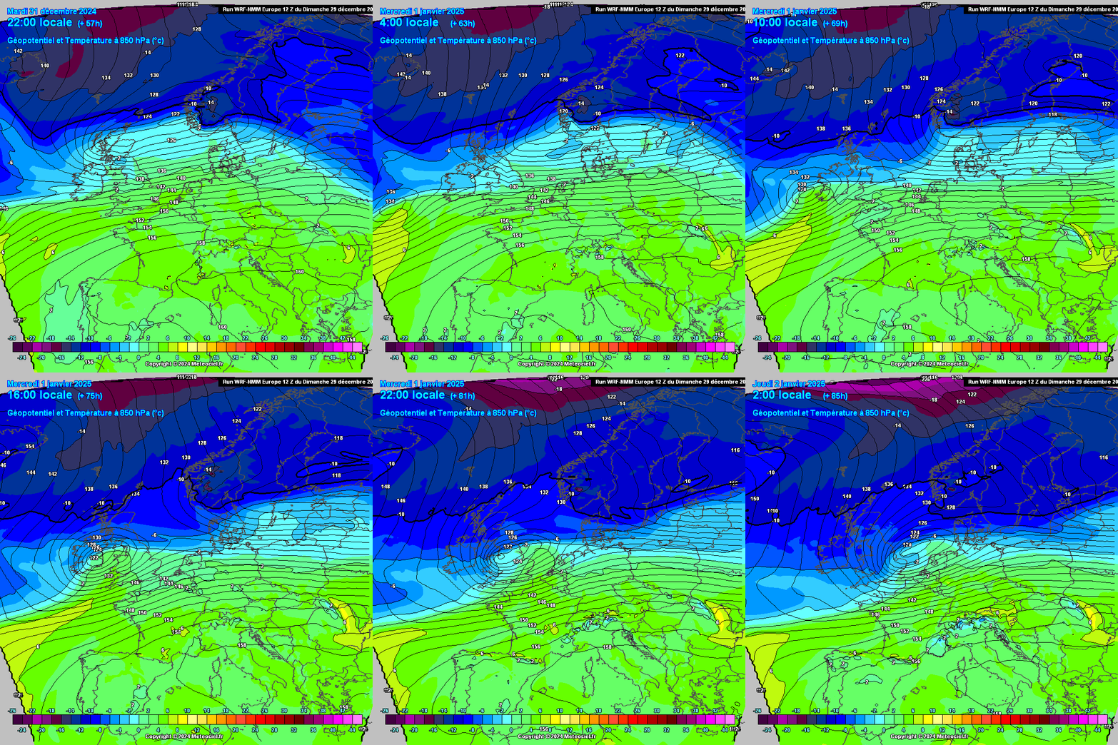
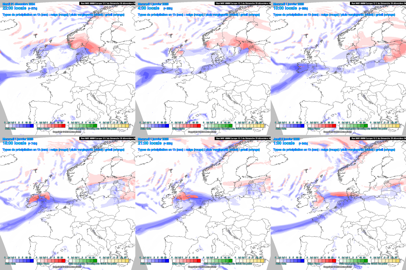
    Starting with New Year's Day a weather system will be moving in off the Atlantic and the northern side of this will be hitting a much colder airmass moving down from the Arctic. There will be plenty of moisture with the developing system as it moves close to or over Ireland and as the frontal zones meet the cold air the precipitation turns to snow firstly on the northern side of the system but on the western side also later on.

    Current risk areas for 1 - 5cm of snow at low levels:

    • Ulster
    • Connaught
    • North Munster
    • Leinster

    I don't expect the snow with this system to be particularly disruptive at this point. I suspect there is more likely to be a yellow warning issued rather than orange.

    Lying snow is likely to be hanging around for quite a few days.

    January 2nd onwards

    After New Years Day, while there'll be some snow showers drifting in to northern counties most of the country will be mainly dry for a few days but it will be very cold especially at night under high pressure with clear skies and slack winds.

    Very cold setup under high pressure…

    Indicative night-time minimum temperatures will particularly low where snow has settled. Random selection for the 3rd of January but this will be the case probably all nights until at least Sunday:

    Daytime temperatures are also going to really struggle to get above freezing everywhere from Thursday:

    After the drier and very colkd few days things might get even more exciting for those who like this type of weather depending on how things evolve over the next couple of days.

    And there are some interesting ways it could go starting to emerge for the latter part of the forecast period but that's more uncertain at this point. Here's a tease 😁

    In summary a much, much colder period of icy winter weather starting New Year's Day and continuing for the forseeable future, there will be openings for snowfall throughout in various places. We just have to nail down the smaller scale specifics.

    Exciting eh?😎

    Post edited by DOCARCH on


«13456758

Comments

  • Registered Users, Registered Users 2 Posts: 1,393 ✭✭✭WolfeEire
    Clare (430ft asl)


    ECM brings the low pressure system further south producing snowfall along the M6 Motorway from Galway to Dublin on Wednesday.

    #HighwayToHail

    www.x.com/wolfeeire


  • Registered Users, Registered Users 2 Posts: 6,025 ✭✭✭Storm 10


    Not a mention of Snow on ME forecast now possibly in the North time will tell


  • Registered Users, Registered Users 2 Posts: 24,707 ✭✭✭✭Kermit.de.frog


    The UK Met Office has the track slightly south of that again.

    A thin line between the haves and have-nots as usual 😋 Probably won't be resolved satisfactorily until within 48 hrs.


  • Registered Users, Registered Users 2 Posts: 9,045 ✭✭✭Tom Cruises Left Nut


    Right, it can stay where it is now cause it's right over me 😂😂


  • Registered Users, Registered Users 2 Posts: 1,393 ✭✭✭WolfeEire
    Clare (430ft asl)


    The ECM joins the GFS and GEM in demolishing the Atlantic block by next Sunday. Based on today's model output, the midweek cold blast into North America fires up the jetstream acting as a slingshot for Atlantic lows to break across the Atlantic toward Ireland.


    The icebox GFS op run was very much an outlier.


    www.x.com/wolfeeire


  • Advertisement
  • Registered Users, Registered Users 2 Posts: 230 ✭✭Condor24


    Milder ECM. Look away if you want a decent colder spell.


  • Registered Users, Registered Users 2 Posts: 3,315 ✭✭✭JanuarySnowstor


    I think you should have held off until the ECM Kermit. It's all gone kaput since you penned this thread half an hour ago 😆 🤣 😂


  • Registered Users, Registered Users 2 Posts: 197 ✭✭Hairypoppins


    5 days is fine ,I'll take it


  • Registered Users, Registered Users 2 Posts: 1,020 ✭✭✭Oíche Na Gaoithe Móire


    When I saw Kermit opened a thread I had 2 thoughts:

    1. Great, the frog is on board!
    2. This is great, it'll keep him off the Gazza thread😂

    'Where have you gone Joe DiMaggio? A nation turns It's lonely eyes to you.'


  • Registered Users, Registered Users 2 Posts: 1,393 ✭✭✭WolfeEire
    Clare (430ft asl)


    Plenty of time for change yet. A disruptive storm showed up yesterday for this coming Wednesday with snowfall for northern counties. Today it has shifted well south and become somewhat of a flabby mess. Modelling by default will always favour a quicker breakdown of a cold spell and, in this case, time will tell if it has overegged the Atlantic's speedy recovery.

    www.x.com/wolfeeire


  • Advertisement
  • Registered Users, Registered Users 2 Posts: 17,573 ✭✭✭✭nacho libre


    The high flatters to deceive and is too far west to force those pesky lows under come the weekend. Still if we get a three day cold spell I will be happy. I know some people have enjoyed the recent weather, but I am not one of them. Give me a few cold and clear days over the mild overcast muck we've had over the last week anytime


  • Registered Users, Registered Users 2 Posts: 496 ✭✭DayInTheBog


    I'll get in early with the question.

    On Wednesday, Will I be able to get from Tralee to Slea Head in the morning, passing the valley of the mad (real place) to get some cool shots on the headland and get home safely in the early evening?

    All answers on a postcard please 🤣


  • Registered Users, Registered Users 2 Posts: 1,516 ✭✭✭esposito


    It appears to be impossible these days to get a prolonged cold spell in these parts! And what really frustrates me is the fact we can be affected in a bad way by the cold on the east coast of the United States spilling out into the poxy Atlantic Ocean firing up the poxy Jetstream. I am clinging onto the fact the models may be overreacting/ have a bias for bringing back the Atlantic too soon. It’s like a kick in the ***s.


  • Registered Users, Registered Users 2 Posts: 1,393 ✭✭✭WolfeEire
    Clare (430ft asl)


    The CMA and KMA have gone the same way as the rest of this afternoon's model output. As Nacho alluded to in the last post, a regressing Greenland high has not helped. The primary cause of the breakdown imo is the cold plunge deep into North America which has fired up the jet and produced the familiar conveyer belt for Altantic Lows.

    www.x.com/wolfeeire


  • Registered Users, Registered Users 2 Posts: 1,393 ✭✭✭WolfeEire
    Clare (430ft asl)


    Gleann na nGealt is on the lower slopes of the mountains there so you should be fine re: snow disruption. The timing of the winds on Wednesday remains uncertain though. The roads leading to where you are going are very narrow so debris could be a problem. Wait until Tuesday before making travel plans as timings of the strongest winds will be likely known then.

    www.x.com/wolfeeire


  • Moderators, Science, Health & Environment Moderators Posts: 17,276 Mod ✭✭✭✭Gonzo


    a fairly big downgrade to the longevity of this cold spell across the board apart from the GFS 12z operational which is not well supported, we need some major upgrades tomorrow or else the Atlantic once again will get the final laugh. Always seems to be the way for us.

    Overall the ECM ensembles from the 12z are still in a better shape than the GFS which is really only going for a 3 day cold spell while the ECM is favouring a 5 to 6 day cold spell.

    the uncertainty begins from Sunday 5th which is 6 days away, so I still believe there is a little bit of hope that this might fix itself early tomorrow. Tomorrow mornings runs will be critical.


  • Registered Users, Registered Users 2 Posts: 1,393 ✭✭✭WolfeEire
    Clare (430ft asl)


    Those lows just come spilling out of Newfoundland racing across the Atlantic in this afternoons runs. Once they do, we end up locked into a zonal setup. I do note there is a 60hPA difference between the 32 perturbations next Sunday so scope for change does exist.

    As I posted earlier this morning, I wasn't overly enthused about the ensembles re: long term cold, but the shift toward milder weather since has been quite dramatic. I genuinely would love to know what singular set of data fed into all models to make them go for a breakdown this Sunday.

    www.x.com/wolfeeire


  • Registered Users, Registered Users 2 Posts: 1,690 ✭✭✭Billcarson


    Always seems to be a fly in the ointment regarding us getting cold spells. This time the cold going into America seems to be whats gone against us. Bloody typical. Anyway let's see what we can get out of our cold snap next week and if at all possible can we get something longer.


  • Registered Users, Registered Users 2 Posts: 496 ✭✭DayInTheBog


    I knew I should have gone yesterday as originally planned.😭. I normally take a day to myself with the camera on Slea Head around new year.

    Wait and hope at this stage. 😀


  • Registered Users, Registered Users 2 Posts: 1,393 ✭✭✭WolfeEire
    Clare (430ft asl)


    The 12z run from the new ECMWF (European Centre for Medium-Range Weather Forecasts) AIFS model prolongs the coming week's cold spell well into the following week by keeping the heights in place over Greenland for longer, which serves to prevent a quicker breakdown

    www.x.com/wolfeeire


  • Advertisement
  • Registered Users, Registered Users 2 Posts: 2,322 ✭✭✭mcburns07


    Why can't people just enjoy the cold spell instead of fixating on a breakdown?


  • Registered Users, Registered Users 2 Posts: 377 ✭✭kittyn


    Add to that the runs will chop and change for another while yet and not to panic 😜


  • Moderators, Science, Health & Environment Moderators Posts: 17,276 Mod ✭✭✭✭Gonzo


    Dissapointment, so many people here want a decent cold spell, something we haven't seen in 6 years, a huge difference between the GFS 00z ensembles and the current 12z ensembles which have completely wobbled from a week+ cold spell down to a 2/3 day cold snap. The Icon, GEM, KMA have also wobbled to match the GFS 12z ensemble run. Wobbles all around this evening. I believe we could still be in with one last shot for the overnight and early morning runs to go back on the track we want but big cross agreement wobbles like this are usually hard to correct.

    It's also kinda frustrating the warm/mild models in the winter never seem to wobble, the warm plume of Christmas a perfect example, that was flagged for weeks beforehand and never buckled once.


  • Registered Users, Registered Users 2 Posts: 197 ✭✭Hairypoppins


  • Registered Users, Registered Users 2 Posts: 199 ✭✭Ros4Sam24


    Gfs 18z puts the snow threat over the midlands and slightly further south than previous runs


  • Registered Users, Registered Users 2 Posts: 17,573 ✭✭✭✭nacho libre


    I suppose that AI model is a crumb of comfort- the ECM experimental model is verifying very well. You would hope the other models flip towards it overnight. Is it also teasing a reload in the far reaches of fi?


  • Registered Users, Registered Users 2 Posts: 1,393 ✭✭✭WolfeEire
    Clare (430ft asl)


    18Z GFS. Wintry precip for much of Ireland on New Year's Day. Snow more likely toward evening as the system pulls away toward southwest England and draws in much colder air.

    www.x.com/wolfeeire


  • Registered Users, Registered Users 2 Posts: 1,552 ✭✭✭SeaBreezes


    Cork snow shield holding fast I see.


  • Registered Users, Registered Users 2 Posts: 1,393 ✭✭✭WolfeEire
    Clare (430ft asl)


    Tonight's GFS showing up some very cold nights. Thursday night into Friday morning below.

    www.x.com/wolfeeire


  • Advertisement
  • Registered Users, Registered Users 2 Posts: 3,230 ✭✭✭Dazler97


    Hhopefully it snows here in carrick on shannon, I know nights could be down to -6c locally


  • Registered Users, Registered Users 2 Posts: 2,240 ✭✭✭squarecircles


    Wibble wobble.... Wibley.


  • Registered Users, Registered Users 2 Posts: 2,726 ✭✭✭.Donegal.


    Hard to take the gfs seriously when it has changed so much over this past 12 hours. It’s out on its own with that amount of widespread snow cover as well for Wednesday.


  • Registered Users, Registered Users 2 Posts: 1,393 ✭✭✭WolfeEire
    Clare (430ft asl)


    Highest ground only until the system pulls away in the late afternoon into evening. SOme places will get lucky with backedge snow. A very different looking GFS run overall tonight btw

    www.x.com/wolfeeire


  • Registered Users, Registered Users 2 Posts: 2,726 ✭✭✭.Donegal.


  • Registered Users, Registered Users 2 Posts: 3,315 ✭✭✭JanuarySnowstor


    IF the gfs were to be right, Widespread disruption to the travel network on one of the busiest days of the year!! Gfs control represents tonight's thoughts


  • Advertisement
  • Moderators, Science, Health & Environment Moderators Posts: 17,276 Mod ✭✭✭✭Gonzo


    trying to look on the bright side, we could still lose week 2 of January to the Atlantic but we are still on track for a 3 to 4 day cold spell with temperatures down to possibly -8C or lower and some ice days so if todays downgraded charts verify this would still be the coldest spell we've had since 2018. This is alot better than nothing and a huge improvement over December. On the GFS 18z snow is much reduced not just for Ireland but for much of the UK as well, however 3 to 4 very cold days still appear on track.

    Still tracking the rolling out 18z and from it much of Ireland could be non stop sub zero for about 3 to 4 days.


  • Moderators, Science, Health & Environment Moderators Posts: 12,515 Mod ✭✭✭✭Meteorite58


    Don't you just love those very low temperatures over the snow fields ! 😀

    ECM a tidier stretch of snow on the latest run.


  • Registered Users, Registered Users 2 Posts: 1,393 ✭✭✭WolfeEire
    Clare (430ft asl)


    The 18z GEFS ensembles are cooler than the 12z generally from Wednesday afternoon through and beyond next weekend. A massive 16-17c spread from Sunday. A lot to work out regarding Wednesday's system so let's see what tomorrow brings.

    18Z and 12z ensembles below.

    www.x.com/wolfeeire


  • Registered Users, Registered Users 2 Posts: 17,573 ✭✭✭✭nacho libre


    Should we be looking east in FI? In the meantime for New Years Day I would prefer everything is shunted a bit further south rather than back edge snow after hours of rain. A three to four day cold spell with temperatures struggling to get above zero would be great. It has been too long since we have seen such temperatures in January.


  • Registered Users, Registered Users 2 Posts: 2,726 ✭✭✭.Donegal.


    Aperge some southern areas/wicklow mountains with accumulations on NYD. Nothing elsewhere bar a few snow showers at the end of the run for the North


  • Advertisement
  • Moderators, Science, Health & Environment Moderators Posts: 17,276 Mod ✭✭✭✭Gonzo


    GFS 18z keeping the dream alive for now.

    Temperatures barely get above 0C between January 1st and January 13th. This has to be a very cold outlier.


  • Registered Users, Registered Users 2 Posts: 3,315 ✭✭✭JanuarySnowstor


    'Cooler' a word makes me always think of a bottle of budweiser on a hot sunny day. An Arctic plunge in the 1st January is surely deserved of the word cold


  • Registered Users, Registered Users 2 Posts: 199 ✭✭Ros4Sam24


    18z ensembles trending the right way


  • Moderators, Science, Health & Environment Moderators Posts: 17,276 Mod ✭✭✭✭Gonzo


    GFS 18z ensembles still rolling out but a substantial shift back to cold more in line with the 00z. Models really are struggling with this cold spell.

    We need to wake up tomorrow and see all the other models fall back in line with tonights GFS 18z. Tomorrow mornings runs are going to be the most important ones of 2024 and indeed this winter.


  • Registered Users, Registered Users 2 Posts: 17,573 ✭✭✭✭nacho libre


    The ECM AI and the lastest GFS are seeing things the same way in FI. If they are correct we could be looking at an extended cold spell, but of course as others have said it could all go pear shaped. What seems most likely is a three to four day cold spell, albeit mainly dry. I will take that over the usual early January mild dross!


  • Registered Users, Registered Users 2 Posts: 2,726 ✭✭✭.Donegal.


    New aperge run out since and it’s marginally worse. Downgrades for Britain too


  • Moderators, Science, Health & Environment Moderators Posts: 12,515 Mod ✭✭✭✭Meteorite58


    The American Models out in front for cold and snowfall. The GFS use to have a cold bias, wonder has it been corrected much?

    Wind wise the system seems to be producing stronger winds in the UK.

    I'm thinking if we get snow in the midlands it could be heavy wet snow and could turn very hard in the sharp frost later overnight Weds into Thurs , it is fairly extreme cold for Ireland whereby the snow could get compacted and stay around for quite a few days.

    Edit : just to note ECM 18Z is showing quite lackluster 850hPa temps on tis run for Weds with very little snowy outcome. Small trace of the former LP on this run now well to the S of Ireland giving little in the way of wind yet still quite wet in southern counties.

    Never seen the ECM to change so much in such a short time.

    Post edited by Meteorite58 on


  • Registered Users, Registered Users 2 Posts: 1,020 ✭✭✭Oíche Na Gaoithe Móire


    'Where have you gone Joe DiMaggio? A nation turns It's lonely eyes to you.'


  • Registered Users, Registered Users 2 Posts: 1,393 ✭✭✭WolfeEire
    Clare (430ft asl)


    GEFS back to where it was in the 00z

    www.x.com/wolfeeire


  • Moderators, Science, Health & Environment Moderators Posts: 17,276 Mod ✭✭✭✭Gonzo


    I remember that, It was sub zero for almost 2 weeks and barely a cloud in the sky, I remember Scotland getting to -27C or something like that.


  • Advertisement
This discussion has been closed.
Advertisement